
Thunderstorms, some severe, may produce heavy to excessive rainfall and isolated flooding over portions of the Southern Plains through Saturday. Widespread showers and thunderstorms will spread east into the Great Lakes, Ohio Valley, Mid Atlantic and Northeast. Dry conditions, combined with gusty winds will continue to support an elevated fire weather threat in the Desert Southwest. Read More >
Wakefield, VA
Weather Forecast Office
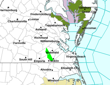
Severe Thunderstorms Possible Late This Evening & Overnight
Submit Storm Reports To NWS Wakefield
Southeast Radar Mosaic / Mid-Atlantic & Northeast Radar Mosaic
|
|
|
|
|
|
|
|
CURRENT CONDITIONS
LAND OBSERVATIONS HOURLY
RIVER LEVEL SUMMARY
GIS MARINE REPORTS
MARINE OBSERVATIONS
EARTHQUAKE MONITOR
TIDES NEXT FEW DAYS
FORECASTS
Zone Forecast
Marine Forecast
Fire Weather Forecast
Air Quality Forecast
River Level Forecast
Summer Rip Current Forecast
Graphical Rain Totals
Core TEXT Products
RSS/XML
MODEL-DATA
NCEP Models
ENSO
Nearshore Wave Prediction System (NWPS)
Meso Analysis
Local WRF Model
Statistical Models
SAFETY/EDUCATION
Awareness Weeks Messages
CoCoRAHS
SkyWarn
Storm Ready
Weather Ready Nation
Brochures
Safety
WindChill Chart
Heat Index
US Dept of Commerce
National Oceanic and Atmospheric Administration
National Weather Service
Wakefield, VA
10009 General Mahone Highway
Wakefield, VA 23888
757-899-4200
Comments? Questions? Please Contact Us.


 Coastal Flood
 Heat
Heat