Overview
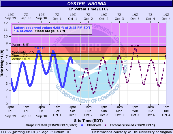
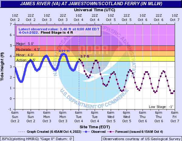
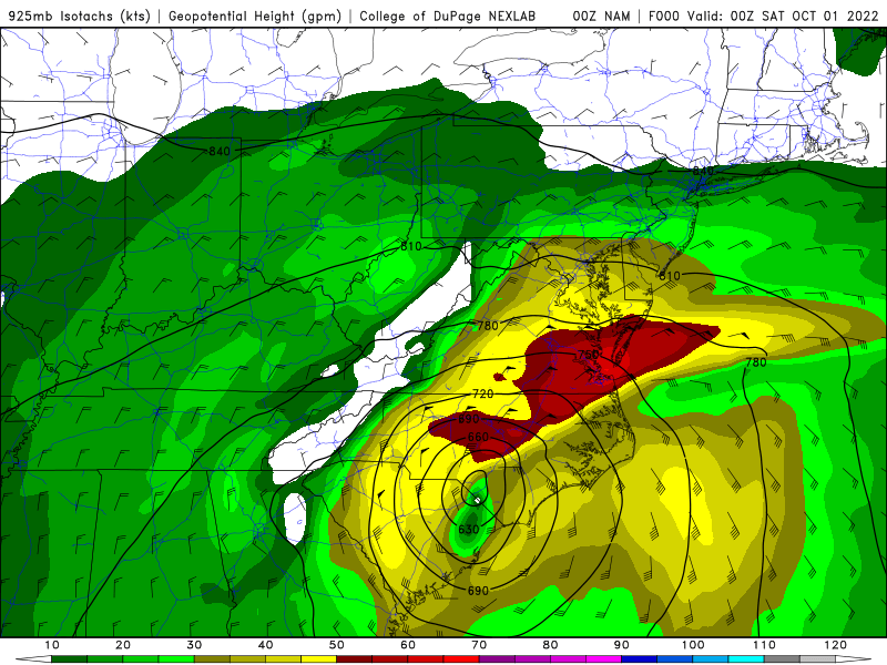
Hurricane Ian made its second landfall near Myrtle Beach, South Carolina during the afternoon of Friday, September 30th. Meanwhile, a broad area of 1025-1030mb high pressure extended from the western Great Lakes to New England. Ian had many extratropical characteristics when it made landfall in South Carolina. The gradient between Ian (well to our south) and the surface high (well to our north) was resulting in 25-45 mph NE winds (with gusts of 35-60 mph) over land areas. The highest gusts (45+mph) were generally confined to near the bay/coast. Winds were even higher over the bay, Lower James River, and ocean due to the relatively warm waters, strong boundary layer wind field (925mb winds ~ 50 knots), and resultant unstable marine boundary layer. The strong NE winds allowed for water levels to rapidly rise during the day and into the evening on the 30th. Tidal anomalies were > 3.5 feet above normal across parts of the Lower Chesapeake Bay. Winds rapidly diminished from south to north Friday night-Saturday morning (10/1) as they veered to the E then SE. However, with lingering high seas, there was plenty of water trapped in the bay and tidal rivers. Also, the overnight high tide occurred just a couple of hours after winds had begun to diminish. Therefore, many of our sites actually saw water levels peak during the overnight high tide where moderate to locally major tidal flooding occurred. The worst impacts were felt along the tidal James River, where water levels at Jamestown exceeded major flood thresholds by 0.5 feet MLLW. In fact, VDOT had to suspend operation of the Jamestown Ferry for a period early Saturday morning (service resumed by 7 AM EDT). See the hydrographs for detailed tide observations for each site. While 1 to locally 6 inches of rainfall fell from 9/30-10/1, flash flooding was not an issue given the (very) dry antecedent conditions.
Ian weakened considerably as it tracked northwest into west-central portions of Virginia and North Carolina on 10/1. However, secondary cyclogenesis occurred off the coast of Virginia on 10/2 and 10/3 (Sunday into Monday) as the mid-level low associated with Ian's remnants tracked toward the coast. This caused winds to quickly increase out of the north late Sunday into Monday, with the highest wind gusts (up to 50-60 mph) confined to locations near the coast. This helped to cause another round of tidal flooding in the lower bay/tidal James and in areas along the Atlantic coast of MD, VA, and NC as seas increased to 12-18 feet by early Monday morning (10/3). Fortunately, the tidal flooding was not as severe as forecast, in part due to the fact that winds were more out of the N-NNW than NNE (as some of the guidance...especially the GFS...were predicting). Nevertheless, minor to moderate (locally major in VA Beach and Eastern Currituck County) was observed on Monday. See the Hydrographs in "Coastal Flooding: Round 2" for more details. Water levels quickly fell from 10/3-10/4 as winds became NW and diminished some (but still were gusting to 40 mph near the coast with gale force gusts over the ocean).
Coastal Flooding: Round 1
Hydrographs
 |
 |
 |
 |
| Jamestown, VA (James City County) | Sewell's Point, VA (Norfolk) | Lynnhaven Inlet (VA Beach) | Yorktown, VA (York County) |
More Hydrographs
 |
 |
 |
 |
| Windmill Point, VA (Lancaster County) | Kiptopeke, VA (Northampton County) | Oyster, VA (Northampton County) | Nansemond River in Suffolk |
Coastal Flooding: Round 2
Hydrographs
 |
 |
 |
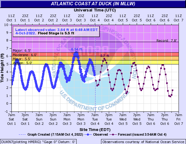 |
| Jamestown, VA (James City County) | Sewell's Point, VA (Norfolk) | Lynnhaven Inlet (VA Beach) | Duck, NC (Just south of Currituck/Dare County line) |
More Hydrographs
 |
 |
 |
 |
| Ocean City Inlet, MD | Kiptopeke, VA (Northampton County) | Fort Monroe, VA (City of Hampton) | Money Point, VA (City of Portsmouth) |
Rainfall and Wind Maps with Selected Reports
 |
 |
Environment
Synoptic summary.
 |
 |
 |
| Loop of 12z 500mb analysis from 9/27 to 10/3 | WPC Loop of Ian's Second Landfall | WPC Loop from 12z/01 to 12z/03 (secondary cyclogenesis) |
925 mb summary.
 |
 |
 |
 |
| 18z/30 925mb Heights/Winds | 00z/01 925mb Heights/Winds | 18z/30 925mb Temperatures/Heights/Winds | 00z/01 925mb Temperatures/Heights/Winds |
Selected NAM Surface Analyses.
 |
 |
| 18z/30 NAM Surface Analysis | 00z/01 NAM Surface Analysis |
 |
Media use of NWS Web News Stories is encouraged! Please acknowledge the NWS as the source of any news information accessed from this site. |
|


 Coastal Flood
 Heat
Heat