
Scattered strong to severe thunderstorms will persist over the central to southern High Plains this weekend with a severe weather and flash flooding threat. A late season storm will bring low elevation rain and high elevation snow to portions of California, Nevada and Oregon through the weekend. Winter Weather Advisories are in place for the Sierra for snow totals of 3-6", locally higher. Read More >
Overview
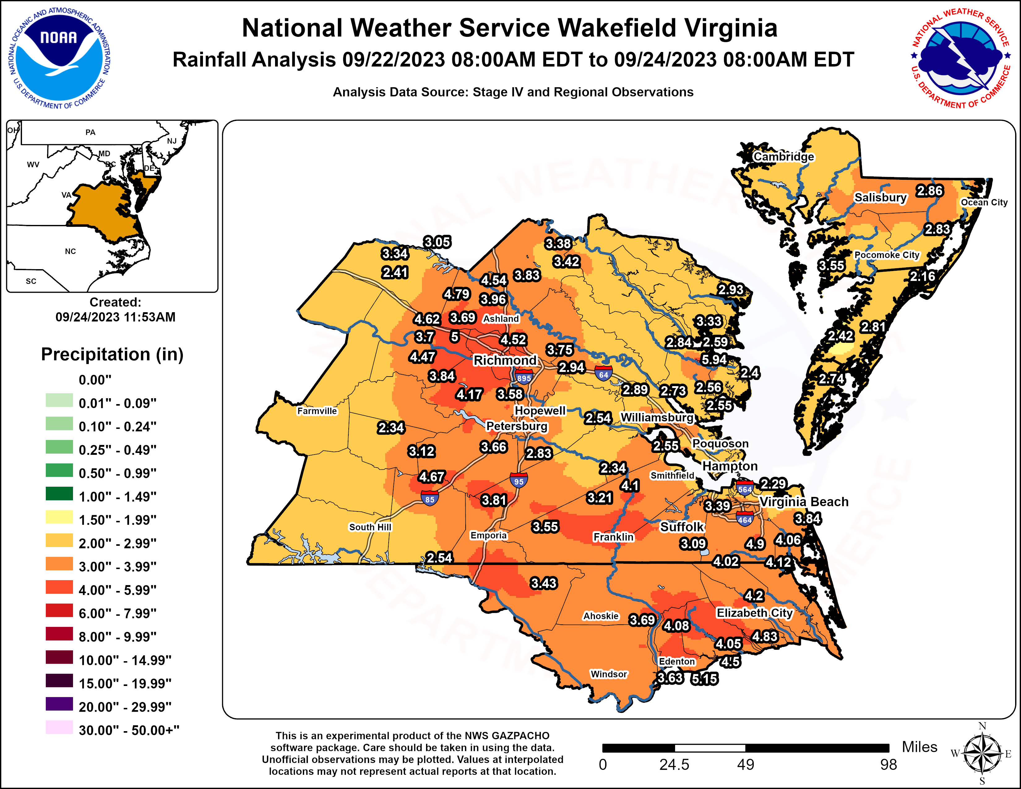
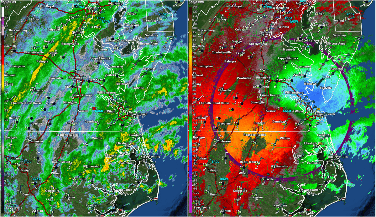
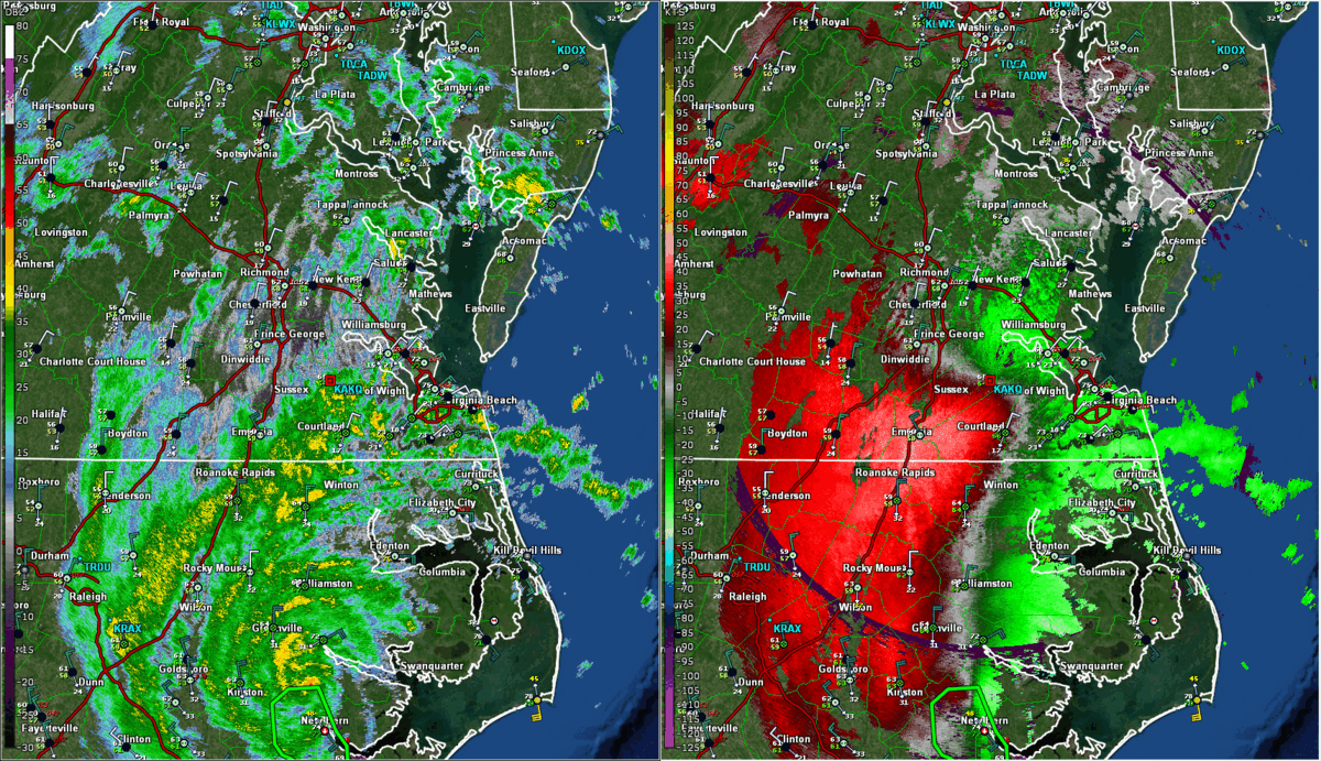
Tropical Storm Ophelia formed about 150 miles southeast of Wilmington, NC during the afternoon of Friday (9/22) when a non-tropical area of low pressure acquired some tropical characteristics (including convection near the center which had a warm core). Ophelia steadily tracked northward before making landfall in Emerald Island, NC (in the southeast part of the state) at 6:20 AM on Saturday, 9/23 as a tropical storm with 70 mph winds. Ophelia gradually weakened (and lost tropical characteristics) as it tracked northward toward the Wakefield CWA during the day on Saturday. Ophelia tracked northward roughly along the I-95 corridor during the afternoon and evening hours on Saturday, reaching the Richmond Metro Area while weakening to a depression. Ophelia became an post-tropical cyclone shortly thereafter and exited to the north/northeast on Sunday. Northeast winds gusted as high as 50-65 mph near the VA/NC coast well in advance of Ophelia Friday evening-early Saturday morning (due to a tight gradient between high pressure over New England and the tropical storm to the south), with 25-45 mph gusts farther inland. Winds turned to the SE near the coast on Saturday and a few gusts to 40-45 mph were observed (while winds remained NE inland west of the low track). Bands of rain (with embedded squalls/thunderstorms near the coast) began to move in late Friday and persisted through much of Saturday (although the rain largely ended near the coast by midday Saturday). As the center of the storm tracked up I-95 during the afternoon and evening, an area of heavy rain accompanied it, with rainfall rates of 0.5-1.5"/hour observed for a few hours from Emporia, VA to the Richmond Metro Area. Some areas saw 3-4" of rain from this band. As a result, there were numerous road closures but no reports of water rescues as rain rates were relatively lower than what we have seen during past tropical systems as PWs were only 1.75-1.95" in the Richmond Metro (near the center of the storm) as Ophelia was losing tropical characteristics. Normally, PWs are easily 2.5"+ in the center of systems that are fully tropical. Also, antecedent conditions were quite dry.
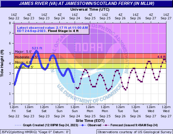
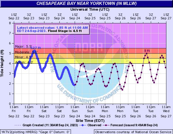
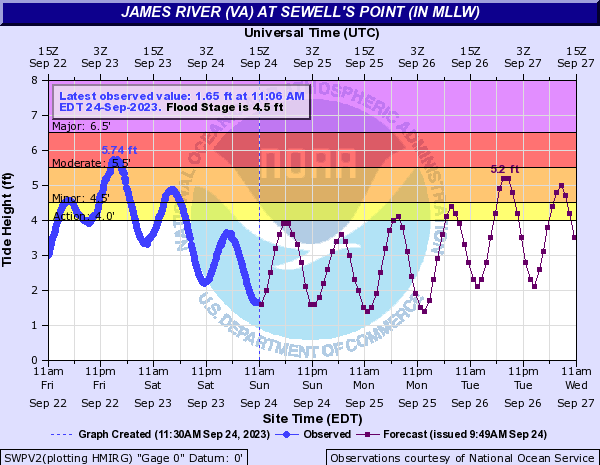
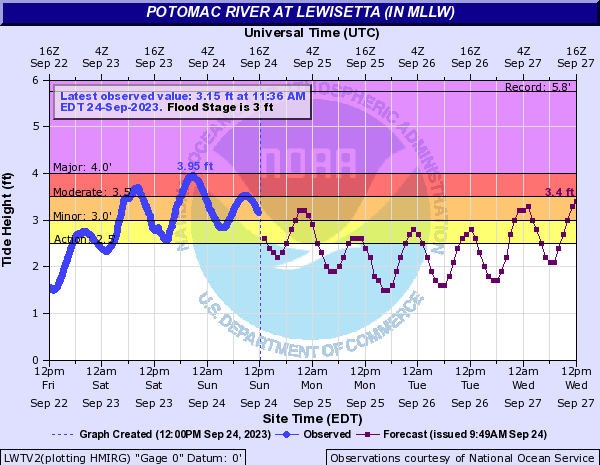
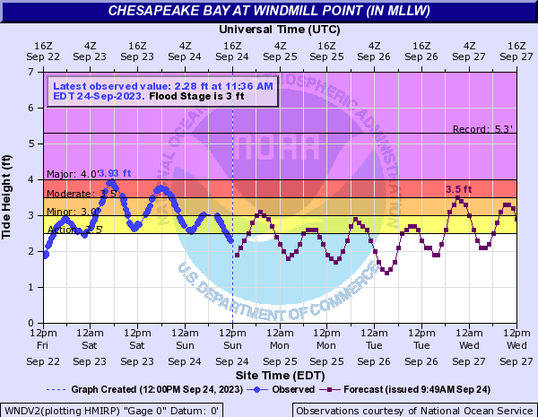
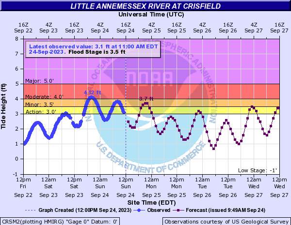
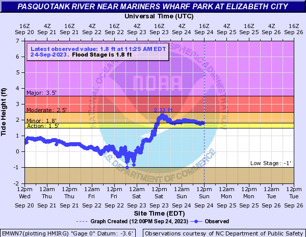
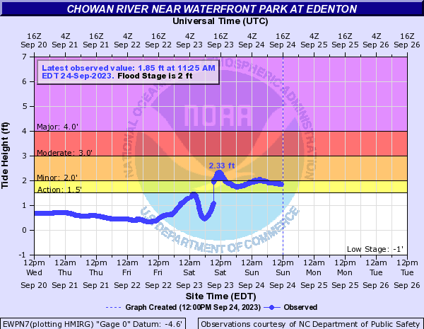
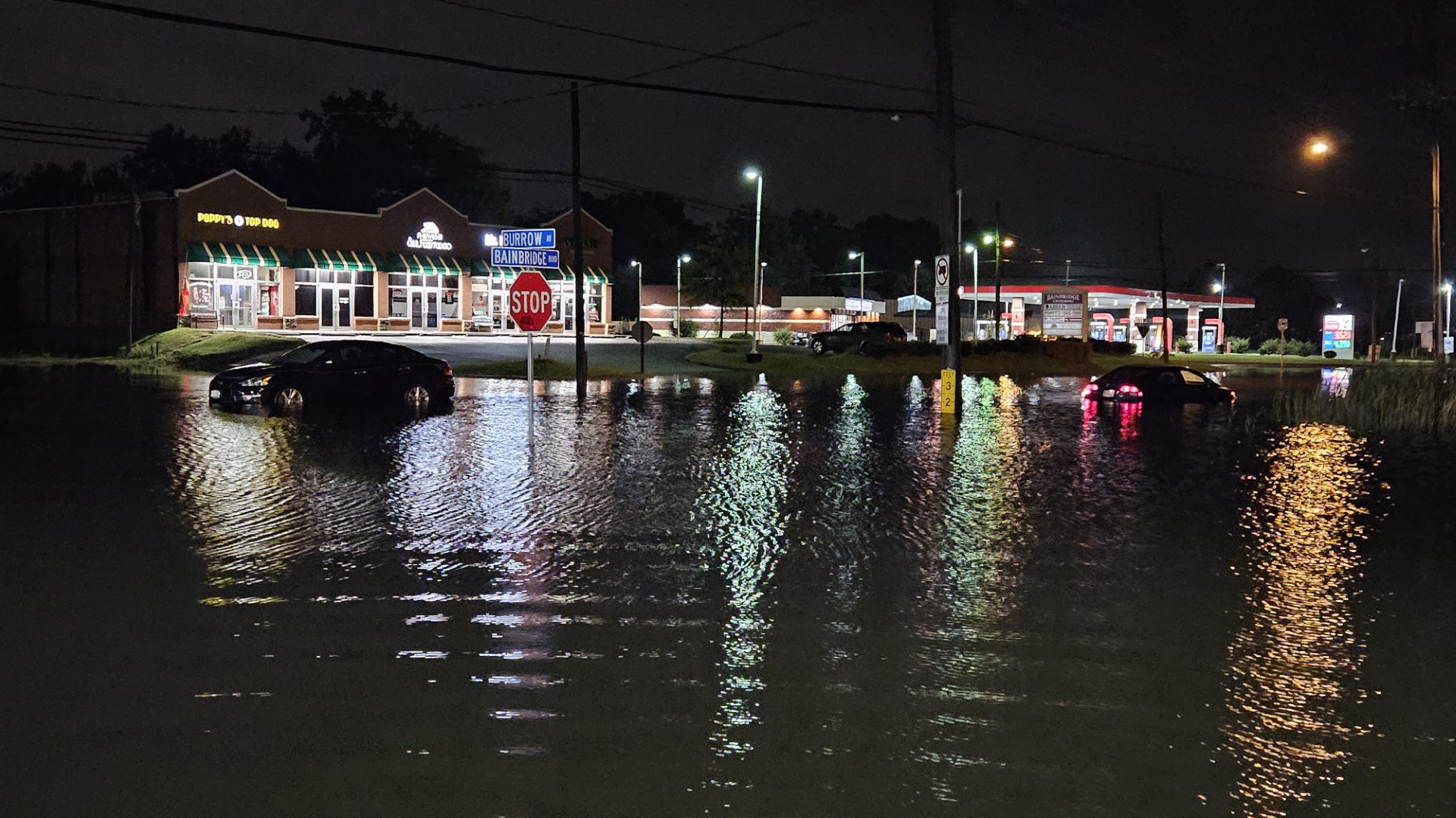
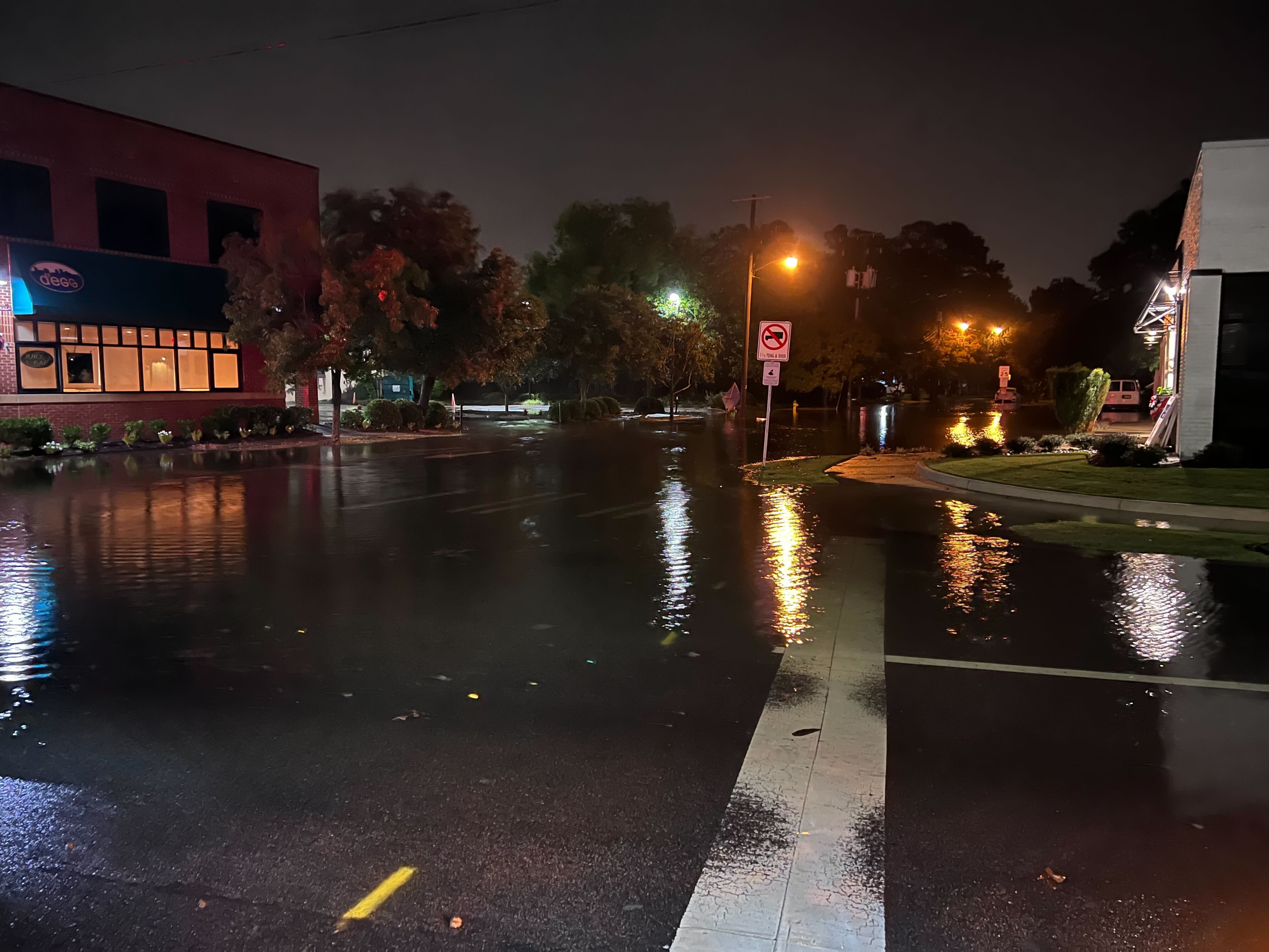
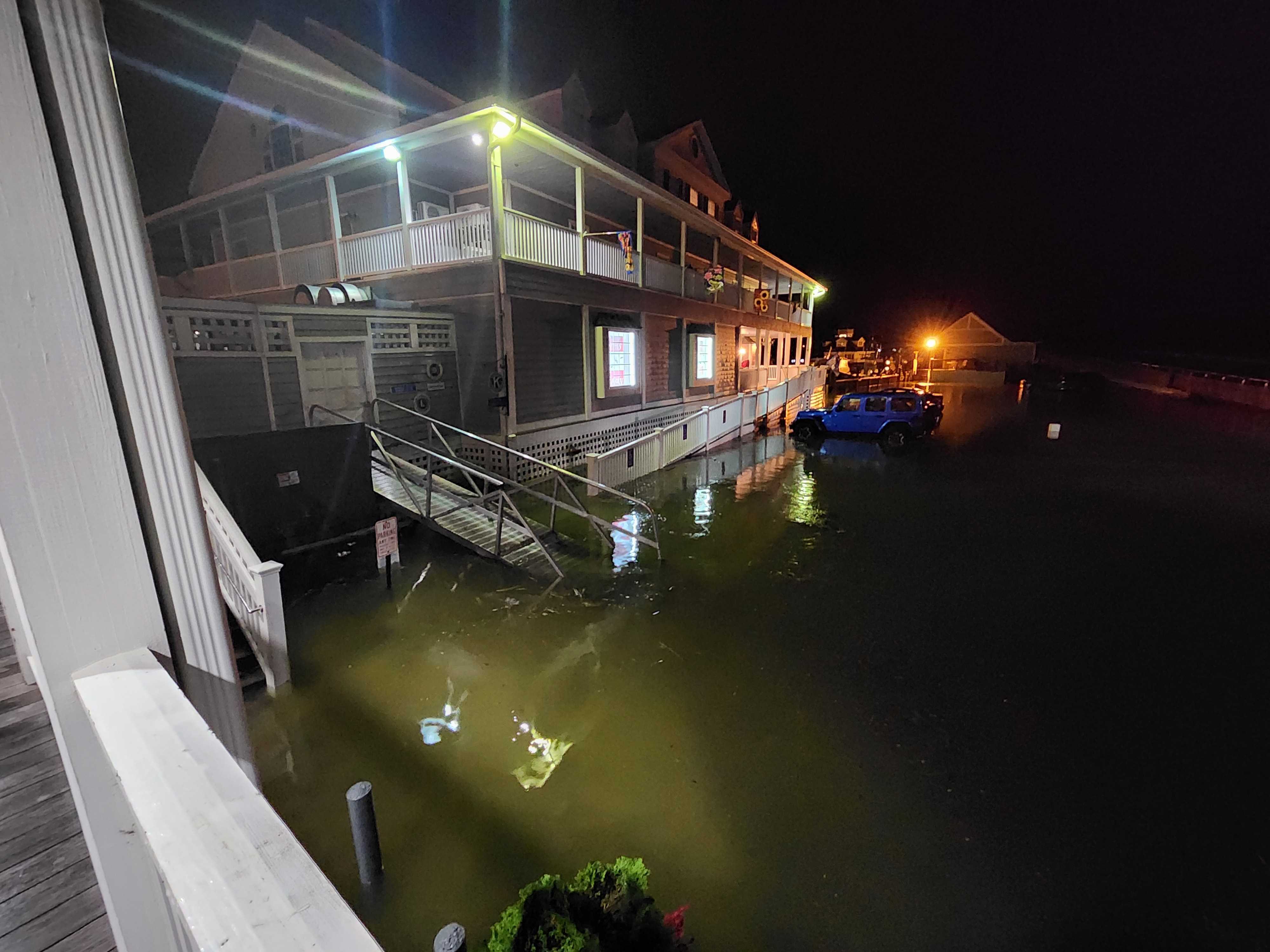
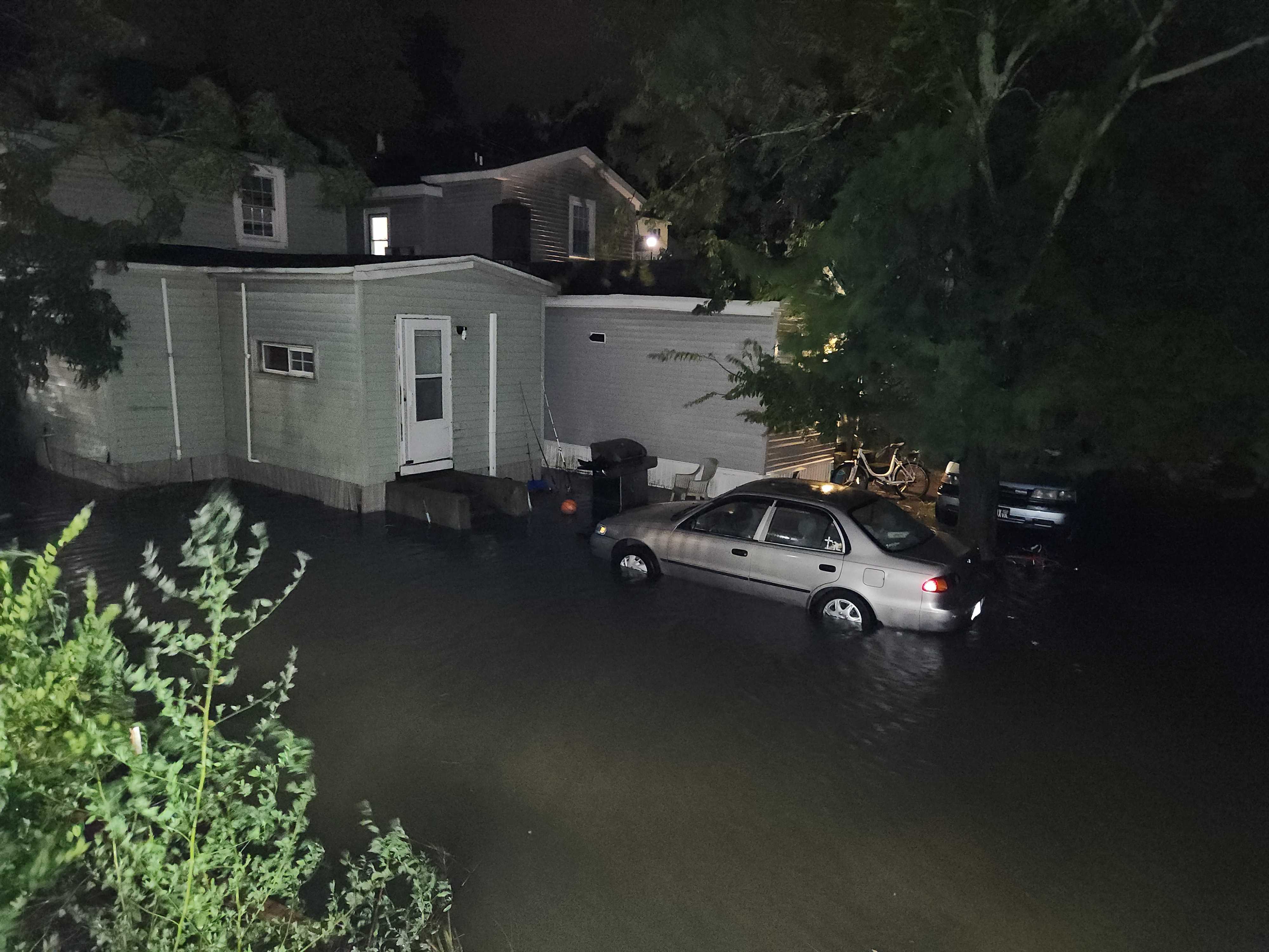
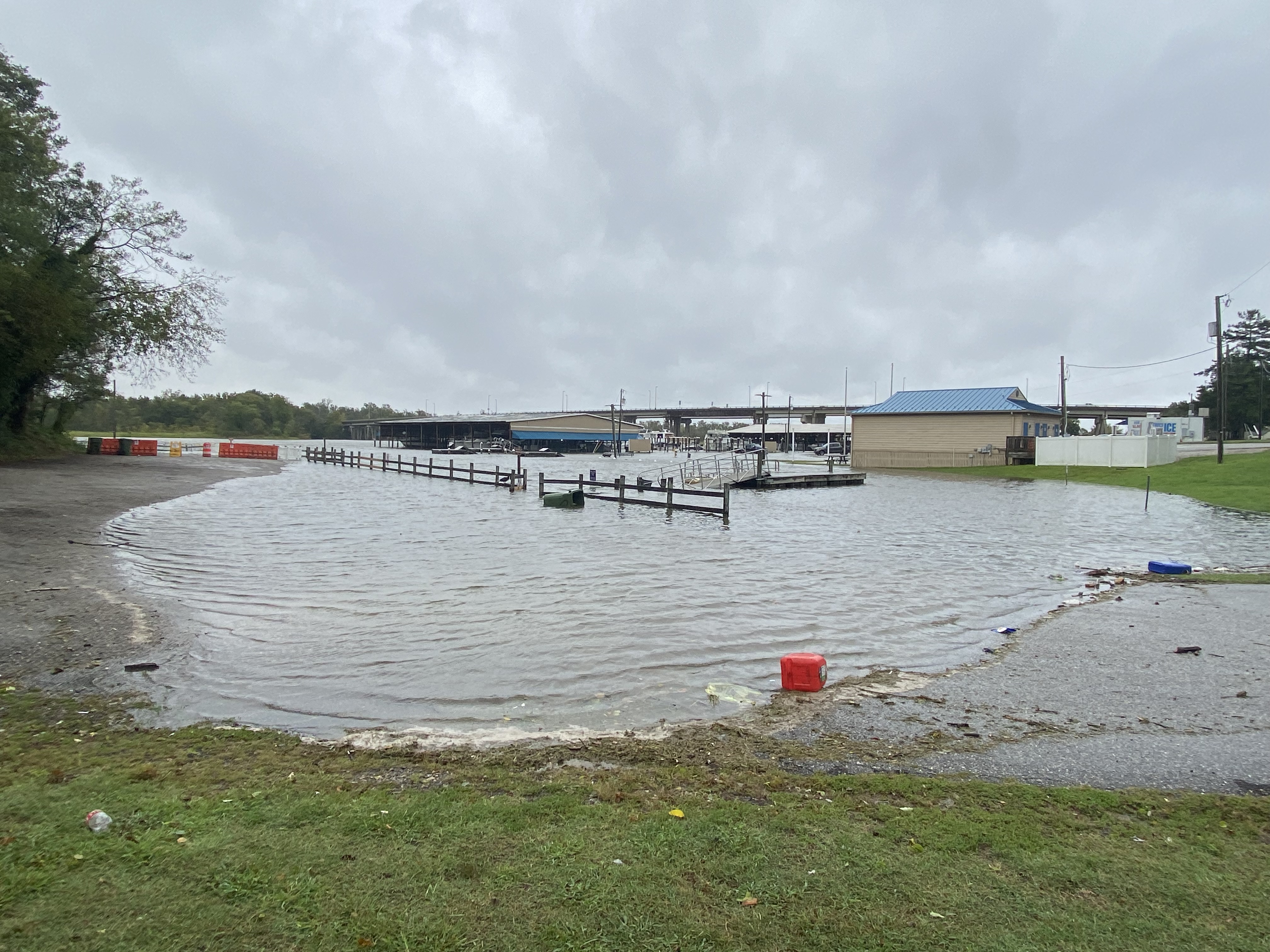
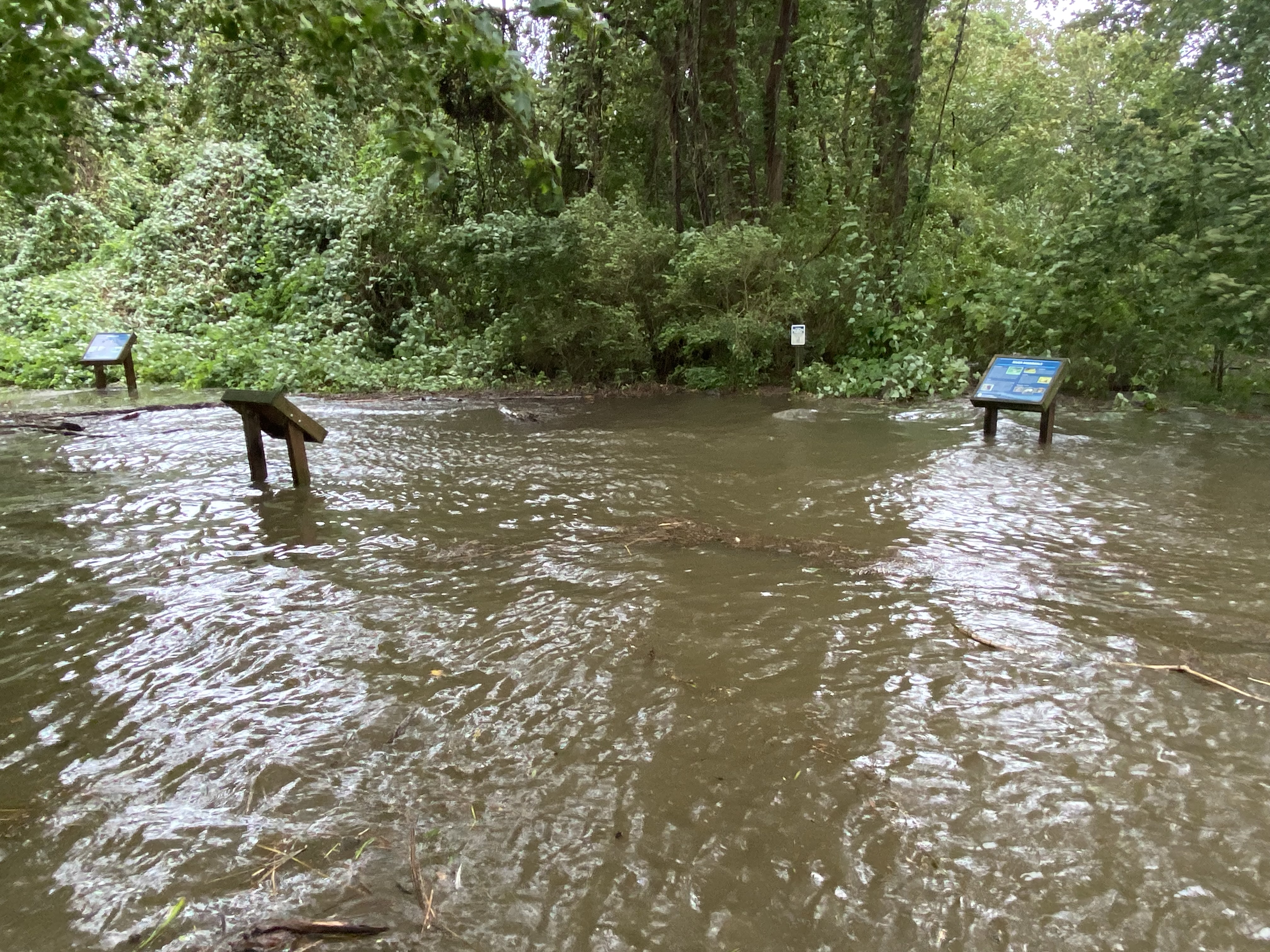
In addition to the rainfall, moderate to major tidal flooding was observed across much of the area Friday night through Saturday evening. Water levels approached (or even slightly exceeded) +3ft MHHW in a couple spots in the lower bay/lower James River. In fact, water levels at Jamestown were the highest observed since 2016 (which caused disruptions to the Jamestown-Scotland Ferry). Tidal flooding was even observed as far up the James River as Hopewell. See "Tidal Flooding" section for more details. Last but not least, one brief EF-0 tornado was observed in Belvidere, NC in the northern part of Perquimans County during the morning on 9/23.
For the complete Post Tropical Cyclone Report (PSH), see https://www.weather.gov/akq/TropicalEventSummary.
 |
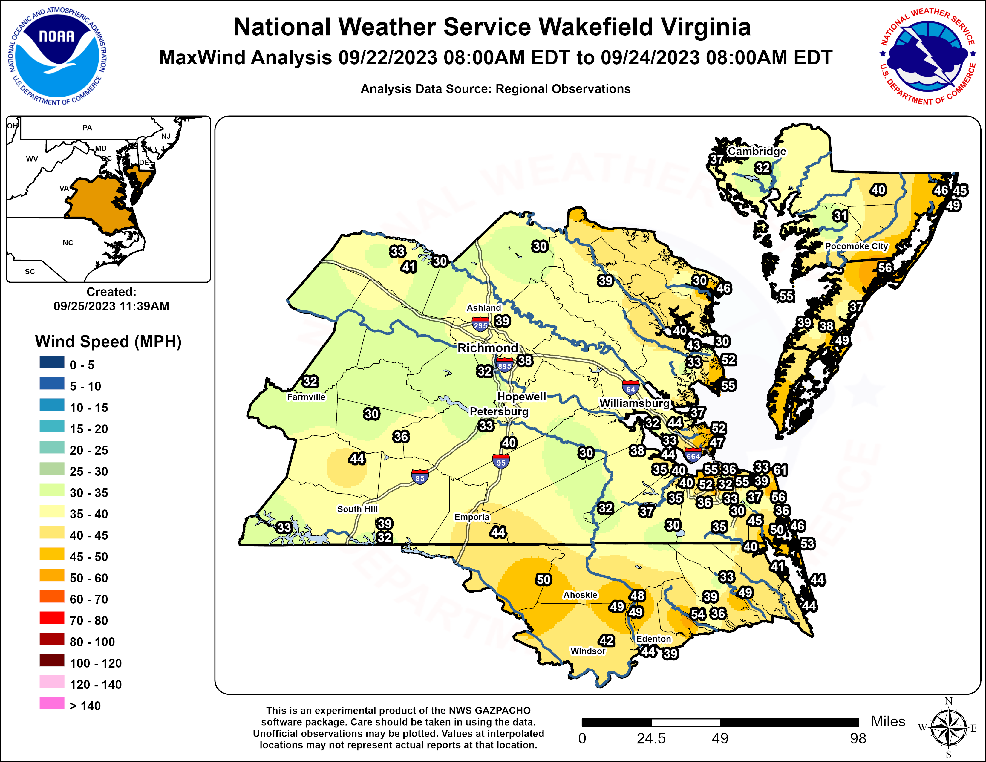 |
| Storm Total Rainfall Map (Click to Zoom In) | Max Wind Gust Map (Click to Zoom In) |
Tornadoes:
|
Tornado - 1 SSE Peach, NC
Track Map 
Downloadable KMZ File |
||||||||||||||||
The Enhanced Fujita (EF) Scale classifies tornadoes into the following categories:
| EF0 Weak 65-85 mph |
EF1 Moderate 86-110 mph |
EF2 Significant 111-135 mph |
EF3 Severe 136-165 mph |
EF4 Extreme 166-200 mph |
EF5 Catastrophic 200+ mph |
 |
|||||
Flooding
Hydrographs
 |
 |
 |
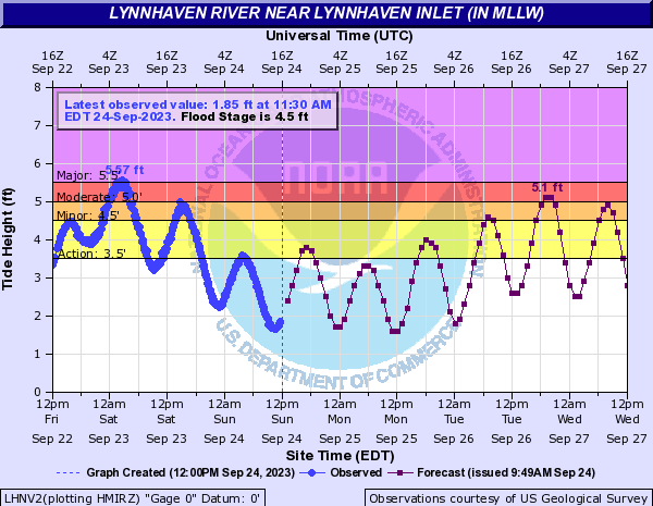 |
| Jamestown, VA | Yorktown, VA | Sewell's Point, VA | Lynnhaven Inlet, VA (VA Beach) |
 |
 |
 |
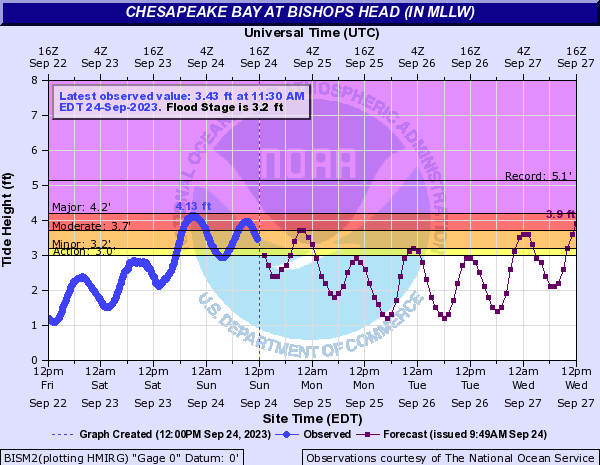 |
| Lewisetta, VA | Windmill Point, VA | Crisfield, MD | Bishop's Head, MD |
 |
 |
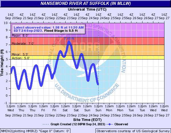 |
| Elizabeth City, NC | Edenton, NC | Nansemond River in Suffolk (VA) |
Photos
Selected Tidal Flooding Photos
 |
 |
 |
 |
| Tidal Flooding in Chesapeake | Tidal Flooding in Norfolk (credit: Craig Moeller) |
Tidal Flooding in Smithfield, VA (credit: Jeff Orrock) |
Tidal Flooding in Smithfield, VA (credit: Jeff Orrock) |
 |
 |
| Tidal Flooding in the Hopewell City Marina (credit: Jonathan McGee) |
More Tidal Flooding in Hopewell (credit: Jonathan McGee) |
Radar Loops
 |
 |
| Radar Loop of 0.5° Reflectivity and Base Velocity from 11 PM on 9/22 to 8 AM on 9/23 in 30 minute increments | Radar Loop of 0.5° Reflectivity and Base Velocity from 8:30 AM to 8 PM on 9/23 in 30 minute increments |
Wind Reports
Public Information Statement
National Weather Service Wakefield VA
1028 PM EDT Sat Sep 23 2023

...HIGHEST WIND REPORTS FROM TROPICAL STORM OPHELIA...

Location                     Speed     Time/Date       Lat/Lon

...York...
Seaford                      37 MPH    0931 PM 09/22   37.19N/76.43W

...Wicomico...
Salisbury Wicomico Airport   40 MPH    0654 AM 09/23   38.33N/75.50W

...Western Hanover...
Richmond Hanover             30 MPH    0301 AM 09/23   37.70N/77.43W

...Western Currituck...
0.5 E Jarvisburg (WEATHERSTE 44 MPH    1040 PM 09/22   36.20N/75.86W
Currituck                    41 MPH    0605 PM 09/22   36.40N/76.02W
1.6 NW Moyock (WEATHERSTEM)  40 MPH    1150 AM 09/23   36.50N/76.16W

...Western Chesterfield...
Richmond Chester             32 MPH    1024 AM 09/23   37.40N/77.52W

...Virginia Beach...
Cape Henry                   61 MPH    1030 PM 09/22   36.93N/76.01W
Oceana NAS Souce             56 MPH    0910 PM 09/22   36.82N/76.02W
Creeds                       50 MPH    0946 PM 09/22   36.59N/76.02W
Back Bay                     46 MPH    0954 PM 09/22   36.67N/75.92W
Virginia Beach               39 MPH    0631 PM 09/22   36.84N/76.06W
Virginia Beach               37 MPH    0710 PM 09/22   36.77N/76.04W
Virginia Beach               36 MPH    0755 PM 09/22   36.75N/75.99W
Virginia Beach               33 MPH    0835 PM 09/22   36.91N/76.04W
McHenry                      30 MPH    0958 AM 09/23   36.75N/76.13W

...Sussex...
Norfolk Wakefld              30 MPH    0319 AM 09/23   36.98N/77.00W

...Suffolk...
Suffolk                      37 MPH    1015 PM 09/22   36.68N/76.60W
Gdr                          30 MPH    0154 PM 09/23   36.61N/76.55W

...Somerset...
Princess Anne                31 MPH    0459 AM 09/23   38.20N/75.69W

...Perquimans...
Chapanoke                    39 MPH    1215 PM 09/23   36.24N/76.36W
Hertford                     36 MPH    1130 AM 09/23   36.16N/76.32W

...Pasquotank...
Elizabeth City Airport       49 MPH    1101 PM 09/22   36.27N/76.18W
Elizabeth City               33 MPH    0113 PM 09/23   36.35N/76.28W

...Nottoway...
Blackstone Fort              36 MPH    0335 PM 09/23   37.07N/77.95W
Crewe                        30 MPH    1115 AM 09/23   37.18N/78.10W

...Northumberland...
Lewisetta, VA                48 MPH    0824 AM 09/23   38.00N/76.46W
Heathsville                  30 MPH    0145 AM 09/23   37.87N/76.42W

...Northampton...
Kiptopeke, VA                40 MPH    0230 AM 09/23   37.17N/75.99W

...Norfolk/Portsmouth...
Norfolk NAS Cham             55 MPH    0911 PM 09/22   36.92N/76.27W
Norfolk Intl Airport         55 MPH    0912 PM 09/22   36.90N/76.20W
Lafayette River              55 MPH    0723 PM 09/22   36.89N/76.32W
South Norfolk Jordan Bridge  55 MPH    1103 PM 09/22   36.81N/76.29W
South Craney Island          52 MPH    1106 PM 09/22   36.89N/76.34W
Portsmouth                   41 MPH    0959 PM 09/22   36.80N/76.33W
Norfolk                      36 MPH    0945 PM 09/22   36.90N/76.26W
Norfolk                      33 MPH    1115 PM 09/22   36.89N/76.21W
Norfolk                      32 MPH    1125 PM 09/22   36.89N/76.26W

...Newport News...
Newport News                 44 MPH    0916 PM 09/22   37.13N/76.50W
Newport News                 33 MPH    1220 AM 09/23   37.12N/76.53W
Ft Eustis Felker             32 MPH    0920 AM 09/23   37.13N/76.62W

...Middlesex...
Saluda                       43 MPH    0515 AM 09/23   37.60N/76.45W
Locust Hill                  40 MPH    0520 AM 09/23   37.61N/76.52W
Stingray Point               30 MPH    0705 PM 09/23   37.55N/76.30W

...Mecklenburg...
Clarksville                  33 MPH    0315 AM 09/23   36.60N/78.55W

...Mathews...
New Point Comfort            55 MPH    1051 PM 09/22   37.33N/76.27W
Gwynns Island                52 MPH    0215 AM 09/23   37.49N/76.27W
North                        33 MPH    0230 AM 09/23   37.45N/76.45W

...Maryland Beaches...
Ocean City                   49 MPH    0337 AM 09/23   38.32N/75.12W
Us 50 Eb On Oc Drawbridge Wi 46 MPH    0254 AM 09/23   38.33N/75.09W
1 SSW Ocean City             45 MPH    0455 AM 09/23   38.33N/75.08W

...Lunenburg...
2 WSW Kenbridge              44 MPH    1225 PM 09/23   36.95N/78.17W

...Isle of Wight...
Carrollton                   32 MPH    1136 PM 09/22   36.93N/76.53W
Franklin J B Ros             32 MPH    0235 AM 09/23   36.70N/76.90W
Smithfield                   30 MPH    1049 PM 09/22   36.99N/76.74W

...Hertford...
Ahoskie Tri Coun             33 MPH    1125 PM 09/22   36.28N/77.17W

...Hampton/Poquoson...
Poquoson                     52 MPH    1046 PM 09/22   37.11N/76.32W
Langley AFB Hamp             47 MPH    1221 AM 09/23   37.08N/76.33W

...Eastern Louisa...
Mineral                      41 MPH    0510 PM 09/23   38.00N/77.91W
Louisa                       33 MPH    0635 PM 09/23   38.02N/77.97W
Bumpass                      30 MPH    0115 PM 09/23   37.97N/77.75W

...Eastern Henrico...
Richmond Intl Airport        38 MPH    0220 AM 09/23   37.52N/77.32W

...Eastern Essex...
Tappahannock                 30 MPH    0655 AM 09/23   37.87N/76.90W

...Eastern Currituck...
3.0 E Knotts Island (WEATHER 53 MPH    0950 PM 09/22   36.52N/75.87W
3.4 S Corolla (WEATHERSTEM)  44 MPH    1040 PM 09/22   36.33N/75.81W

...Dorchester...
Cambridge, MD                37 MPH    1236 PM 09/23   38.57N/76.07W
Cambridge                    37 MPH    0300 PM 09/23   38.55N/76.24W
Blackwater                   32 MPH    0855 AM 09/23   38.45N/76.09W

...Dinwiddie...
Petersburg                   33 MPH    0315 PM 09/23   37.17N/77.52W

...Cumberland...
Farmville                    32 MPH    1155 AM 09/23   37.35N/78.42W

...Chowan...
Edenton                      39 MPH    1050 AM 09/23   36.02N/76.57W

...Chesapeake...
Fentress Naval               45 MPH    1144 PM 09/22   36.70N/76.13W
Chesapeake                   40 MPH    0915 PM 09/22   36.83N/76.40W
Money Point                  36 MPH    0930 PM 09/22   36.78N/76.30W
Chesapeake                   35 MPH    1015 PM 09/22   36.67N/76.32W
Norfolk Hampton              35 MPH    0535 PM 09/22   36.78N/76.45W
Chesapeake                   33 MPH    0300 PM 09/23   36.78N/76.26W

...Caroline...
Fort Walker                  30 MPH    0506 PM 09/23   38.04N/77.24W

...Brunswick...
South Hill Airport           39 MPH    1235 PM 09/23   36.68N/78.03W
Ebony                        32 MPH    1125 AM 09/23   36.55N/78.03W

...Bertie...
Greens Cross                 42 MPH    1117 AM 09/23   36.02N/76.89W
Peanut Belt Research Station 30 MPH    1055 AM 09/23   36.13N/77.18W

...Accomack...
Wallops Island               56 MPH    0152 AM 09/23   37.93N/75.47W
Wachapreague, VA             55 MPH    1254 AM 09/23   37.61N/75.69W
Tangier Sound Light          55 MPH    0440 AM 09/23   37.79N/75.97W
Wachapreague                 49 MPH    0246 AM 09/23   37.60N/75.69W
Onancock                     39 MPH    1013 PM 09/22   37.65N/75.88W
Melfa Accomack               38 MPH    0255 AM 09/23   37.63N/75.77W
Parksley                     37 MPH    0245 AM 09/23   37.73N/75.61W

...Maritime Stations...
6 NW Cape Henry              63 MPH    0906 PM 09/22   37.00N/76.09W
Chesapeake Light Tower       63 MPH    0750 PM 09/22   36.90N/75.71W
Third Island                 62 MPH    1137 PM 09/22   37.04N/76.08W
5 NE Plum Tree Island Refuge 60 MPH    1042 PM 09/22   37.20N/76.27W
Cape Henry, VA               60 MPH    1030 PM 09/22   36.93N/76.01W
Ocean City                   59 MPH    0938 PM 09/22   38.33N/75.08W
Middle Ground Lighthouse     56 MPH    1232 AM 09/23   36.95N/76.39W
Rappahannock Light           55 MPH    1054 PM 09/22   37.54N/76.02W
Lynnhaven Inlet Light 2      55 MPH    0901 PM 09/22   36.92N/76.09W
2 E Stingray Point           54 MPH    0512 AM 09/23   37.57N/76.26W
Poquoson River Light         54 MPH    1056 PM 09/22   37.16N/76.38W
Rudee Inlet                  54 MPH    0934 PM 09/22   36.83N/75.97W
Willoughby Deguassing Statio 53 MPH    0906 PM 09/22   36.98N/76.32W
Hampton Flats                53 MPH    0953 PM 09/22   36.98N/76.36W
Thimble Shoals               53 MPH    1030 PM 09/22   37.05N/76.26W
8 NW Cape Henry              51 MPH    1048 PM 09/22   37.03N/76.08W
Sandbridge                   49 MPH    0635 PM 09/22   36.70N/75.93W
, VA                         48 MPH    1135 PM 09/22   37.01N/76.31W
Yorktown USCG Training Cente 47 MPH    0918 PM 09/22   37.23N/76.48W
Ocean City Inlet             43 MPH    0724 AM 09/23   38.33N/75.09W
Plantation Flats             43 MPH    1255 AM 09/23   37.26N/76.03W
Machipongo                   42 MPH    1120 PM 09/22   37.41N/75.97W
Assateague South Point       41 MPH    0120 AM 09/23   38.21N/75.20W
Silver Beach                 40 MPH    1108 PM 09/22   37.49N/75.97W
Ocean City                   39 MPH    0345 PM 09/22   38.35N/75.08W
Dominion Terminal            38 MPH    1218 AM 09/23   36.96N/76.42W
&&
Rain Reports
Public Information Statement
National Weather Service Wakefield VA
1113 AM EDT Sun Sep 24 2023

...STORM TOTAL PRECIPITATION REPORTS FROM TROPICAL STORM OPHELIA...

Location                     Amount    Time/Date       Provider

...Maryland...

...Somerset County...
Crisfield 0.9 ENE            3.55 in   0700 AM 09/24   COCORAHS

...Wicomico County...
Fruitland 1.8 ENE            3.69 in   0700 AM 09/24   COCORAHS
Salisbury 2.1 SSE            3.44 in   0700 AM 09/24   COCORAHS
Parsonsburg 1.6 WNW          3.38 in   0700 AM 09/24   COCORAHS
Powellville                  2.86 in   1048 AM 09/24   RAWS

...Worcester County...
Ocean Pines                  3.43 in   1055 AM 09/24   CWOP
Snow Hill 0.4 S              2.83 in   0700 AM 09/24   COCORAHS
Ocean City                   1.84 in   0953 AM 09/24   ASOS

...North Carolina...

...Bertie County...
Greens Cross                 3.82 in   1017 AM 09/24   RAWS

...Chowan County...
Edenton 4.3 SE               5.15 in   0700 AM 09/24   COCORAHS
Edenton 0.5 NE               4.38 in   0700 AM 09/24   COCORAHS
Edenton                      4.11 in   1057 AM 09/24   CWOP
1 NNE Rockyhock              4.08 in   1055 AM 09/24   AWS
Edenton 7.4 ESE              3.76 in   0700 AM 09/24   COCORAHS
Edenton 13.3 NNW             3.69 in   0800 AM 09/24   COCORAHS
Edenton                      3.63 in   1050 AM 09/24   AWOS

...Currituck County...
3 SSE Northwest              4.12 in   1055 AM 09/24   AWS

...Northampton County...
Nc Fire Raws No. 6           3.43 in   1018 AM 09/24   RAWS
Henrico                      2.54 in   1045 AM 09/24   CWOP

...Pasquotank County...
Elizabeth City 7.7 SSW       4.83 in   0700 AM 09/24   COCORAHS
Elizabeth City               4.20 in   1013 AM 09/24   RAWS
Elizabeth City               3.94 in   1037 AM 09/24   CWOP
Elizabeth City 5.1 SSE       3.75 in   0700 AM 09/24   COCORAHS
Elizabeth City Airport       3.16 in   1054 AM 09/24   ASOS

...Perquimans County...
Chapanoke                    4.63 in   1100 AM 09/24   CWOP
Hertford                     4.50 in   1045 AM 09/24   CWOP
Hertford                     4.05 in   1100 AM 09/24   CWOP
Hertford 5.2 SSE             3.88 in   0700 AM 09/24   COCORAHS

...Virginia...

...Accomack County...
Onley 0.6 SE                 2.81 in   0800 AM 09/24   COCORAHS
Melfa Accomack               2.42 in   1055 AM 09/24   AWOS
Wallops Island               2.16 in   0954 PM 09/23   ASOS

...Brunswick County...
Alberta 5 N                  4.67 in   0800 AM 09/24   COOP

...Caroline County...
Ruther Glen 1.7 ENE          3.83 in   0700 AM 09/24   COCORAHS
Faph_south 1                 3.42 in   1006 AM 09/24   RAWS
Faph_delos                   3.38 in   1006 AM 09/24   RAWS

...Chesterfield County...
Chesterfield                 4.62 in   1045 AM 09/24   CWOP
Bon Air                      4.47 in   0700 AM 09/24   Public
Midlothian 7.9 S             4.17 in   0700 AM 09/24   COCORAHS
Midlothian 4.7 SSW           4.11 in   0700 AM 09/24   COCORAHS
2 SSW Chester                4.11 in   0800 AM 09/24   COCORAHS
Midlothian 3.0 NNW           3.93 in   0800 AM 09/24   COCORAHS
Moseley 1.7 NNE              3.84 in   0700 AM 09/24   COCORAHS
Winterpock                   3.77 in   1045 AM 09/24   CWOP
Midlothian 5.4 S             3.66 in   0700 AM 09/24   COCORAHS
CHESTERFIELD                 3.62 in   1053 AM 09/24   CWOP
Richmond Chester             3.58 in   1056 AM 09/24   AWOS
Chesterfield                 3.51 in   1100 AM 09/24   CWOP
Chesterfield                 3.46 in   1055 AM 09/24   CWOP
3 SSE Chester                3.30 in   1052 AM 09/24   NWS Employee
Matoaca                      3.26 in   1055 AM 09/24   CWOP
Midlothian 3.5 SSW           3.18 in   0800 AM 09/24   COCORAHS
Chester 6.6 E                2.79 in   0500 AM 09/24   COCORAHS

...City of Chesapeake County...
Chesapeake                   4.90 in   1100 AM 09/24   CWOP
Fentress Naval               4.06 in   1056 AM 09/24   AWOS
8.0 SW Chesapeake Airport    4.02 in   1000 AM 09/24   HADS
Chesapeake 7.3 NE            4.01 in   0800 AM 09/24   COCORAHS
Chesapeake                   3.83 in   1056 AM 09/24   CWOP
Deep Creek                   3.47 in   1030 AM 09/24   HADS
Chesapeake 1.8 NE            3.17 in   0700 AM 09/24   COCORAHS

...City of Franklin County...
Hunterdale                   4.67 in   0600 AM 09/24   COCORAHS

...City of Hampton County...
Hampton 7.2 W                2.74 in   0630 AM 09/24   COCORAHS
Hampton 3.4 W                2.65 in   0839 AM 09/24   COCORAHS

...City of Newport News County...
1 WSW Beaconsdale            2.82 in   0700 AM 09/24   COCORAHS
Newport News 2.5 ESE         2.65 in   0700 AM 09/24   COCORAHS
Newport News                 2.50 in   0954 PM 09/23   ASOS

...City of Norfolk County...
Norfolk Intl Airport         2.29 in   0551 AM 09/24   ASOS

...City of Portsmouth County...
Portsmouth 4.1 SSE           3.45 in   0700 AM 09/24   COCORAHS
Portsmouth                   3.39 in   0559 AM 09/24   CWOP

...City of Richmond County...
Richmond 2.5 WNW             4.97 in   0700 AM 09/24   COCORAHS
Richmond 0.6 SW              4.78 in   0700 AM 09/24   COCORAHS
Richmond 1.1 WSW             4.61 in   0700 AM 09/24   COCORAHS
Richmond 3.9 NW              4.61 in   0700 AM 09/24   COCORAHS
Richmond 1.1 SE              4.27 in   0900 AM 09/24   COCORAHS
Richmond 4.2 NNE             4.10 in   0710 AM 09/24   COCORAHS
Richmond 1.7 N               3.74 in   0700 AM 09/24   COCORAHS

...City of Suffolk County...
Suffolk 1.4 NNW              3.19 in   0731 AM 09/24   COCORAHS
Suffolk                      3.09 in   1035 AM 09/24   AWOS

...City of Virginia Beach County...
Virginia Beach               4.37 in   1045 AM 09/24   CWOP
Virginia Beach 2.4 N         3.92 in   0700 AM 09/24   COCORAHS
Virginia Beach               3.84 in   1100 AM 09/24   CWOP
Virginia Beach 8.2 NNW       3.68 in   0700 AM 09/24   COCORAHS
VIRGINIA BEACH               3.54 in   1100 AM 09/24   CWOP
Virginia Beach 10.1 N        2.79 in   0700 AM 09/24   COCORAHS
Virginia Beach 6.0 WNW       2.74 in   0700 AM 09/24   COCORAHS
Virginia Beach               2.71 in   1045 AM 09/24   CWOP
Virginia Beach 9.1 NNW       2.56 in   0700 AM 09/24   COCORAHS

...City of Williamsburg County...
Williamsburg 1.4 ENE         3.38 in   0700 AM 09/24   COCORAHS
Williamsburg 1.3 SSW         2.70 in   0615 AM 09/24   COCORAHS

...Dinwiddie County...
Petersburg                   3.66 in   1055 AM 09/24   AWOS

...Gloucester County...
James Store 1.5 WNW          3.22 in   0726 AM 09/24   COCORAHS
Gloucester Point 4.7 NW      2.90 in   0800 AM 09/24   COCORAHS
Gloucester Courthouse 3.3 SS 2.73 in   0700 AM 09/24   COCORAHS
Gloucester Courthouse 2.1 S  2.56 in   0700 AM 09/24   COCORAHS
Zanoni 1.7 SSE               2.55 in   0800 AM 09/24   COCORAHS

...Goochland County...
Manakin-Sabot 1.6 SW         5.00 in   0700 AM 09/24   COCORAHS
Crozier                      3.70 in   0700 AM 09/24   COOP

...Greensville County...
Purdy                        3.81 in   1016 PM 09/23   Trained Spotter

...Hanover County...
Montpelier 1.6 NE            4.79 in   0819 AM 09/24   COCORAHS
Rockville 5.1 W              4.62 in   0700 AM 09/24   COCORAHS
Beaverdam 4.3 ESE            4.54 in   0700 AM 09/24   COCORAHS
Ashland                      4.01 in   1100 AM 09/24   CWOP
Montpelier 4.8 E             3.96 in   0729 AM 09/24   COCORAHS
Mechanicsville 6.9 SE        3.75 in   0700 AM 09/24   COCORAHS
Richmond Hanover             3.72 in   0554 AM 09/24   ASOS
Montpelier                   3.69 in   1045 AM 09/24   CWOP

...Henrico County...
Richmond                     4.84 in   1100 AM 09/24   CWOP
Richmond                     4.76 in   1056 AM 09/24   CWOP
Henrico 5.8 W                4.71 in   0832 AM 09/24   COCORAHS
Richmond                     4.71 in   1045 AM 09/24   CWOP
Glen Allen                   4.69 in   1055 AM 09/24   CWOP
Richmond 5.3 NW              4.63 in   0700 AM 09/24   COCORAHS
Glen Allen                   4.52 in   1057 AM 09/24   CWOP
Glen Allen                   4.29 in   1010 AM 09/24   CWOP
Tuckahoe                     3.99 in   1100 AM 09/24   AWS
Laurel 0.8 N                 3.83 in   0830 AM 09/24   COCORAHS
Richmond Intl Airport        3.10 in   1054 AM 09/24   ASOS
Highland Springs 8.1 SE      2.94 in   0830 AM 09/24   COCORAHS
Montrose 4.7 SSE             2.79 in   0700 AM 09/24   COCORAHS

...Isle of Wight County...
Smithfield 0.7 NE            2.89 in   0700 AM 09/24   COCORAHS
Smithfield 1.3 SW            2.70 in   0630 AM 09/24   COCORAHS
Smithfield 7.7 NNW           2.55 in   0700 AM 09/24   COCORAHS

...James City County...
Williamsburg 3.2 WNW         3.70 in   0700 AM 09/24   COCORAHS
Williamsburg 3.2 NW          3.21 in   0800 AM 09/24   COCORAHS
Williamsburg 4.1 WNW         3.19 in   0700 AM 09/24   COCORAHS
Williamsburg 3.2 W           2.96 in   0700 AM 09/24   COCORAHS
Williamsburg 8.2 NW          2.90 in   0800 AM 09/24   COCORAHS
Toano 1.1 SSW                2.89 in   0700 AM 09/24   COCORAHS
Williamsburg 3.4 W           2.84 in   0700 AM 09/24   COCORAHS
Williamsburg 6.8 NW          2.82 in   0700 AM 09/24   COCORAHS

...King and Queen County...
Shacklefords 4.8 NE          2.84 in   0600 AM 09/24   COCORAHS

...Lancaster County...
Mollusk                      3.33 in   1034 AM 09/24   CWOP

...Louisa County...
Louisa                       3.34 in   1045 AM 09/24   CWOP
Mineral 6.9 NNE              3.05 in   0700 AM 09/24   COCORAHS
Louisa 5.1 WSW               2.41 in   0700 AM 09/24   COCORAHS

...Mathews County...
Mathews 1.5 NNE              2.40 in   0700 AM 09/24   COCORAHS

...Middlesex County...
Hartfield                    5.94 in   1056 AM 09/24   CWOP
Locust Hill 1.1 ENE          2.59 in   0700 AM 09/24   COCORAHS

...Northampton County...
Nassawadox 4.6 SW            2.74 in   0700 AM 09/24   COCORAHS

...Northumberland County...
Heathsville 4.6 SE           2.93 in   0700 AM 09/24   COCORAHS

...Nottoway County...
Blackstone Fort              3.12 in   1055 AM 09/24   AWOS
Crewe                        2.34 in   1055 AM 09/24   AWOS

...Powhatan County...
Powhatan 7.8 NE              4.47 in   0800 AM 09/24   COCORAHS

...Prince George County...
Prince George                3.02 in   0700 AM 09/24   COCORAHS
South Prince George 6.8 S    2.83 in   0700 AM 09/24   COCORAHS

...Southampton County...
Franklin 2.6 WNW             4.55 in   0908 AM 09/24   COCORAHS
Ivor 2.7 ESE                 4.10 in   0700 AM 09/24   COCORAHS
Drewryville 2.3 SW           3.55 in   0750 AM 09/24   COCORAHS
Sedley 3.7 N                 3.21 in   0700 AM 09/24   COCORAHS

...Surry County...
Claremont 0.2 SW             2.54 in   0738 AM 09/24   COCORAHS

...Sussex County...
Norfolk Wakefld              2.34 in   0954 PM 09/23   ASOS

...York County...
Williamsburg 4.6 NNW         2.72 in   0800 AM 09/24   COCORAHS
Williamsburg 3.4 ENE         2.65 in   0800 AM 09/24   COCORAHS
&&
Storm History
To be added shortly...
| Image Caption 1 | Image Caption 2 |
Environment
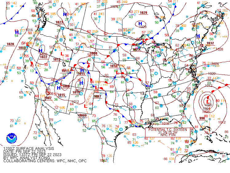
Synoptic summary.
 |
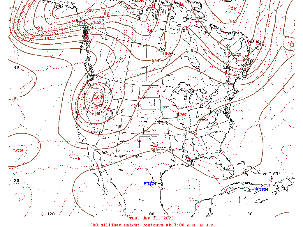 |
| Loop of WPC Surface Analysis from 12z/8 AM on 9/22 to 12z/8 AM on 9/24 | Loop of WPC 500mb Analysis from 12z/8 AM on 9/21 to 12z/8 AM on 9/24 |
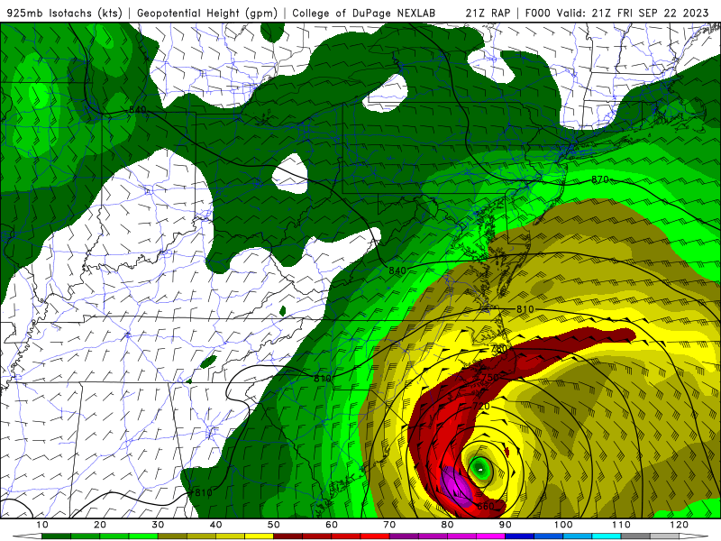
Near-storm environment summary.
 |
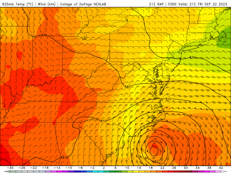 |
| Loop of 925mb RAP Analysis Heights/Winds from 21z/5 PM on 9/22 to 15z/11 AM on 9/23 | Loop of 925mb Rap Analysis Temperatures/Heights/Winds from 21z/5 PM on 9/22 to 15z/11 AM on 9/23 |
Additional environmental data.
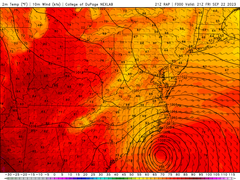 |
| Loop of Surface RAP Analysis MSLP/Temperatures/Winds from 21z/5 PM on 9/22 to 15z/11 AM on 9/23 |
 |
Media use of NWS Web News Stories is encouraged! Please acknowledge the NWS as the source of any news information accessed from this site. |
|


 Coastal Flood
 Heat
Heat