Overview
On the morning of September 17th, the remnant low of Florence was tracking across the Appalachians. The Wakefield CWA was on the east side of the low and a large area of stratiform rain was moving through much of central Virginia on the morning of the 17th with a few thunderstorms over far south-central VA/north-central NC. Winds were out of the SE at the surface at around 10 mph across much of central VA. However, as is the case with many decaying tropical cyclones, winds just above the surface were slower to diminish. The 10 AM 925hPa analysis showed winds out of the south at 30-40 mph. Thus, a large amount of low-level speed and directional shear was in place over parts of the area. This allowed for 0-1 km Storm Relative Helicity values to exceed 250 m2/s2 over our southwestern counties during the mid-morning hours. The morning thunderstorms (including the one that produced the Boydton tornado) formed in a high shear/low CAPE environment before maximum daytime heating. However, the worst of this tornado event was still to come.
Just a slight increase in temperatures (coupled with dew points in the mid 70s across central VA) during the late morning/early afternoon allowed for a noticeable increase in instability. By 2-3 PM on the afternoon of the 17th, daytime heating allowed for SBCAPE to increase to 2500-3000 J/kg just south and east of the Richmond metro (with in excess of 2000 J/kg of MLCAPE). See Environment section for more details. With most of the realized CAPE in the lower part of the atmosphere, 3 PM SPC Mesoanalysis indicated that there were localized values of 0-1km SRH values of 250 m2/s2 over central VA (likely due to local backing of surface winds). Coupled with low LCLs, this created a near-ideal conditions for low-topped supercells to produce tornadoes in the Richmond metro area. As a result, nine additional tornadoes (EF-0 to EF-2) touched down in the Richmond metro between 1:30 and 4:30 PM. This turned out to be the most active tornado day in the AKQ CWA in over a year.
***Please note that some of this data is preliminary and is subject to change***
Tornadoes:
|
Tornado - Boydton, Virginia
Track Map  
|
||||||||||||||||
|
Tornado - Rockville
Track Map 
|
||||||||||||||||
|
Tornado - Winterpock to Moseley
Track Map 
|
||||||||||||||||
|
Tornado - Richmond (city) to Tuckahoe
Track Map 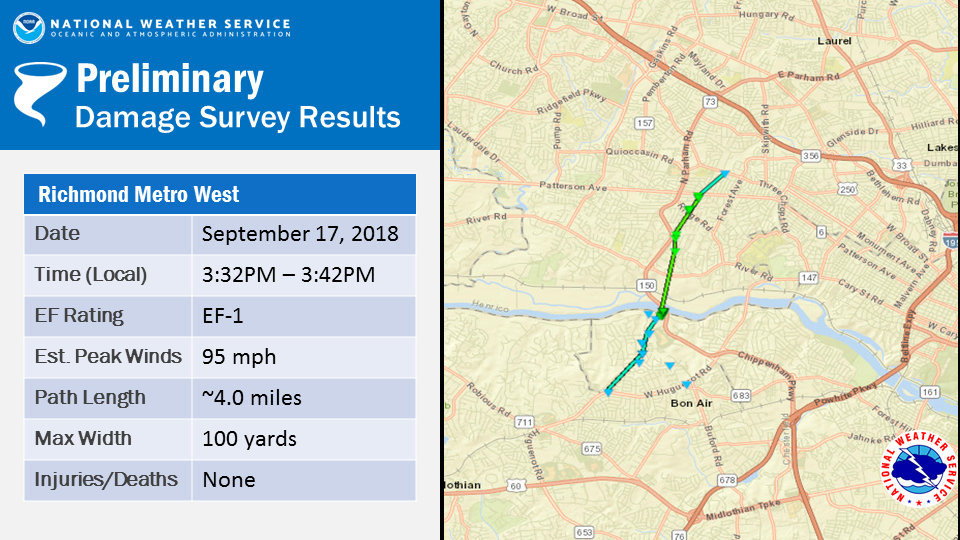
|
||||||||||||||||
|
Tornado - Winterpock to Bon Air
Track Map .PNG)
|
||||||||||||||||
|
Tornado - Petersburg Rd (2 S Genito Rd)
Track Map 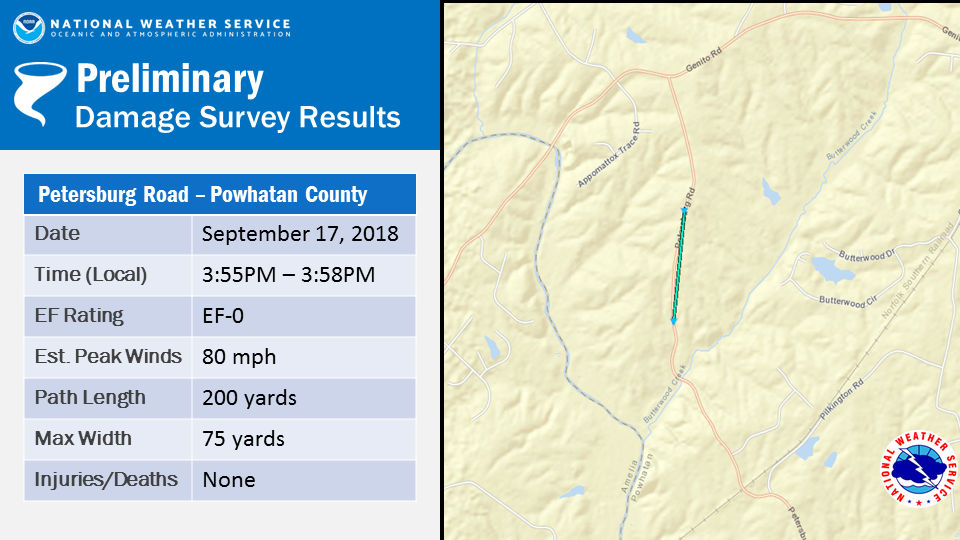
|
||||||||||||||||
|
Tornado - New Kent Road
Track Map 
|
||||||||||||||||
|
Tornado - Richmond Metro East
Track Map 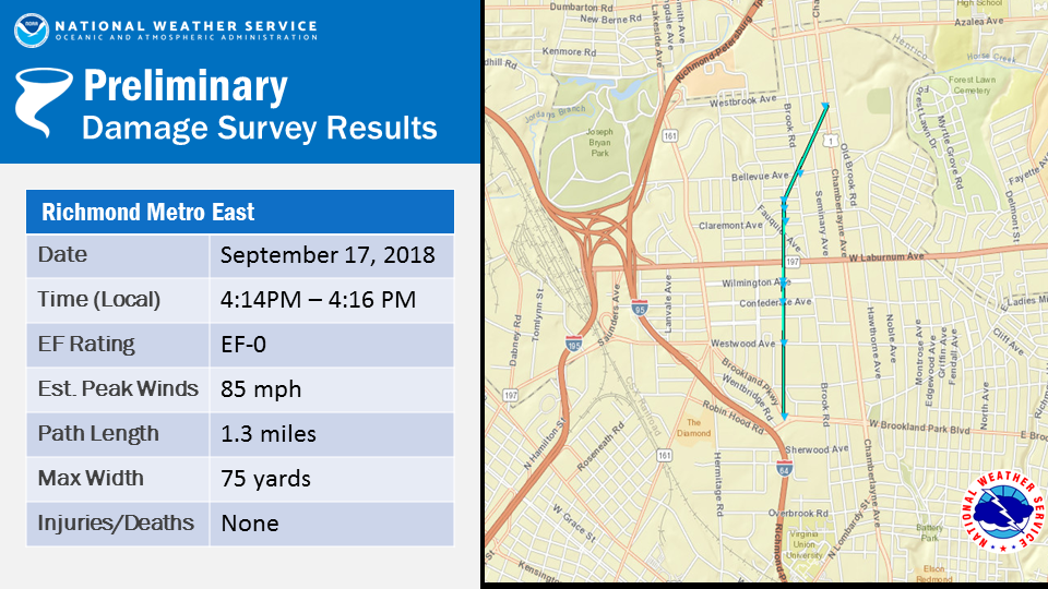
|
||||||||||||||||
|
Tornado - Richmond Forest Hill
Track Map 
|
||||||||||||||||
|
Tornado - Windsor Farms
Track Map 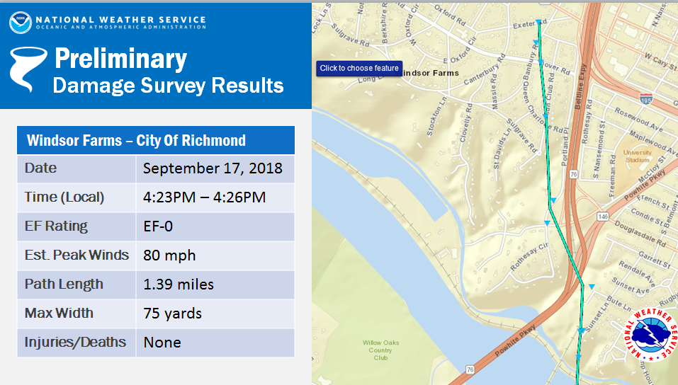
|
||||||||||||||||
The Enhanced Fujita (EF) Scale classifies tornadoes into the following categories:
| EF0 Weak 65-85 mph |
EF1 Moderate 86-110 mph |
EF2 Significant 111-135 mph |
EF3 Severe 136-165 mph |
EF4 Extreme 166-200 mph |
EF5 Catastrophic 200+ mph |
 |
|||||
Photos:
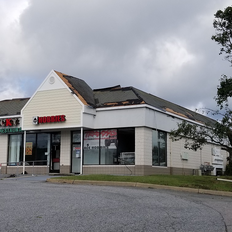
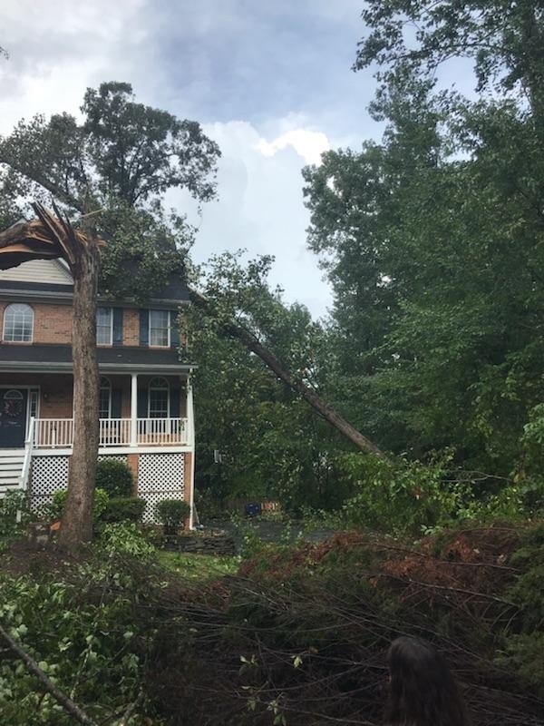
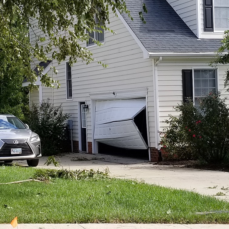
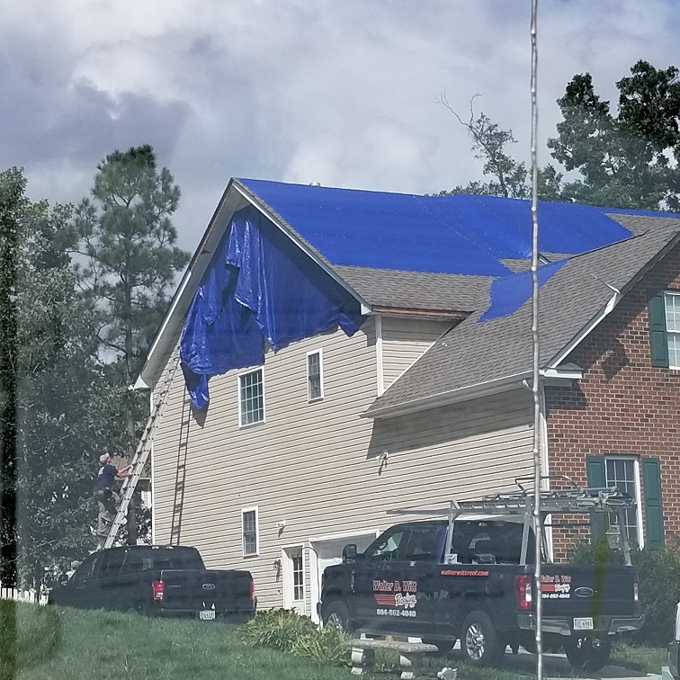
Storm Damage Photos
 |
 |
 |
 |
| Old Dominion Flooring Warehouse (NWS Storm Survey Photo) |
Roof from Old Dominion Flooring (NWS Storm Survey Photo) |
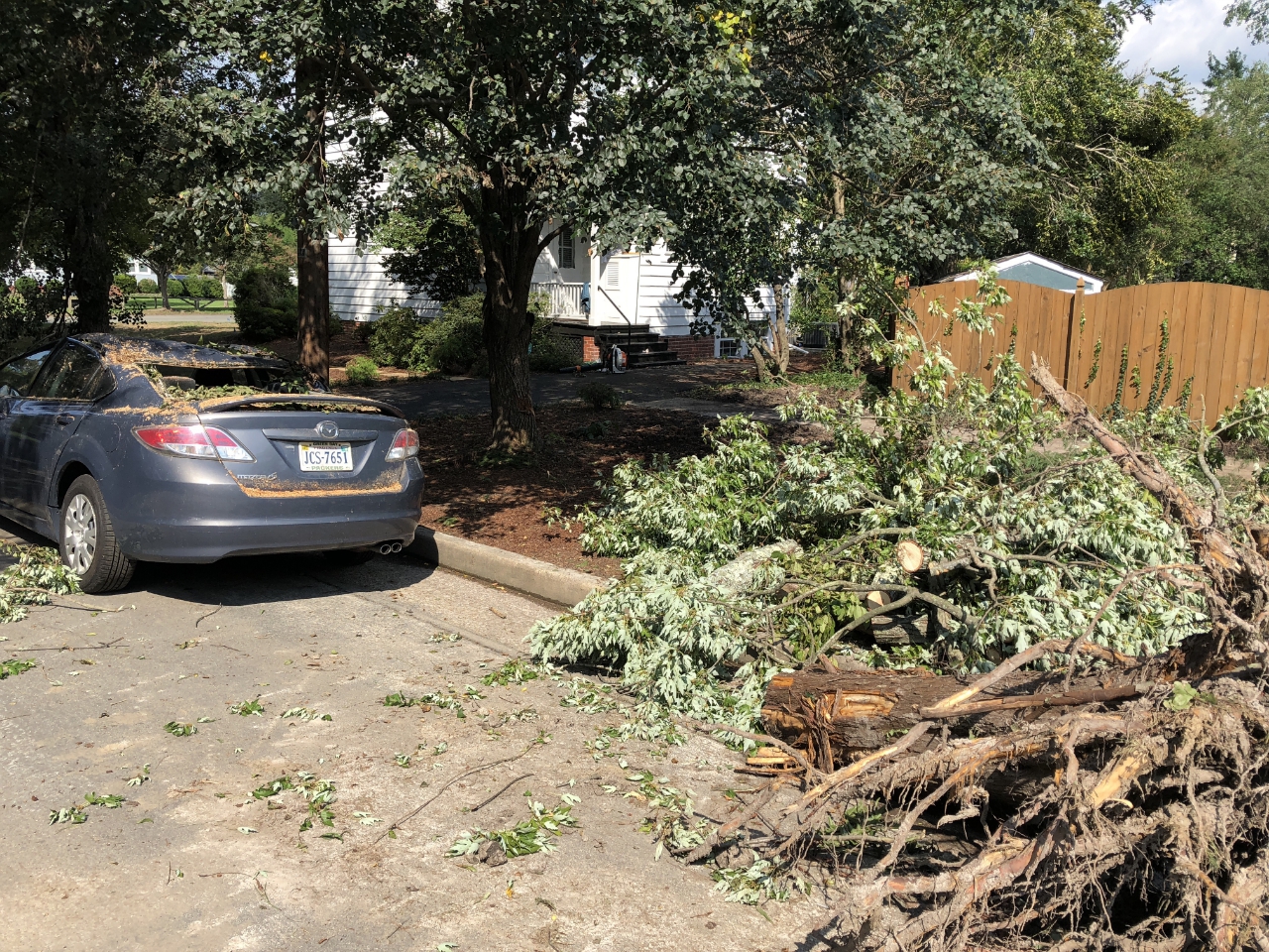
Damage in Chesterfield County (NWS Storm Survey Photo) | Damage in Chesterfield County (NWS Storm Survey Photo) |
 |
 |
 |
 |
| Damage in Chesterfield County (NWS Storm Survey Photo) |
Damage in Chesterfield County (NWS Storm Survey Photo) |
Damage in Chesterfield County (NWS Storm Survey Photo) | Damage in Chesterfield County (NWS Storm Survey Photo) |
 |
 |
 |
 |
| Damage in Chesterfield County (NWS Storm Survey Photo) |
Damage in Chesterfield County (NWS Storm Survey Photo) |
Damage in Chesterfield County (NWS Storm Survey Photo) | Damage in Chesterfield County (NWS Storm Survey Photo) |
 |
 |
 |
 |
| Damage in Chesterfield County (NWS Storm Survey Photo) |
Damage in Chesterfield County (NWS Storm Survey Photo) |
Damage in City of Richmond (NWS Storm Survey Photo) | Damage in Chesterfield County (NWS Storm Survey Photo) |
Radar:
Selected Radar Images
 |
 |
 |
 |
| 3 PM 0.5° Reflectivity Image | 3 PM 0.5° SRM Image | 3:40 PM 0.5° Reflectivity Image | 3:40 PM 0.5° SRM Image |
Storm Reports
NOUS41 KAKQ 190350 CCA
PNSAKQ
MDZ021>025-NCZ012>017-030>032-102-VAZ048-060>062-064>069-075>090-
092-093-095>100-509>525-190900-

Public Information Statement...Corrected
National Weather Service Wakefield VA
454 PM EDT Tue Sep 18 2018

*** NOTE ALL INFORMATION PRELIMINARY AND SUBJECT TO CHANGE ***

...NWS DAMAGE SURVEY FOR 09/17/2018 TORNADO EVENT...

.Chesterfield EF-2...

Start Location...Winterpock in Chesterfield CO Virginia
End Location...Bon Air in Chesterfield CO Virginia
Date...September 17, 2018
Estimated Time...338PM EDT - 356PM EDT
Maximum EF-Scale Rating...EF-2
Estimated Maximum Wind Speed...115-125 mph
Maximum Path Width...350 yards
Path Length...7.5 miles
Beginning Lat/Lon...37.4065, -77.6107
Ending Lat/Lon...37.5101, -77.5635
* Fatalities...1 in Old Dominion Flooring Warehouse
* Injuries...1 in Old Dominion Flooring Warehouse

...Summary...
Beginning in Winterpock, the tornado started as a weak EF-1 before
moving into a residential area north of River Road.  The tornado
reached peak intensity, EF-2 when it crossed Hull Street Road.  At
this point it took off the roof of Gabe's and damaged several other
businesses.  After crossing Hull Street Road, it destroyed the Old
Dominion Warehouse, where one person was killed and at least one
injured. It remained an EF-2 until about Gregwood Drive completely
destroying trees and damaging other structures.  It then quickly
dropped to an EF-0 as it reached Chippenham Parkway, and continued
as an EF-0 toward Route 60 in Bon Air.

.Chesterfield EF-1...

Start Location...Winterpock in Chesterfield CO Virginia
End Location...Moseley in Chesterfield CO Virginia
Date...September 17, 2018
Estimated Time...246PM EDT - 308PM EDT
Maximum EF-Scale Rating...EF-1
Estimated Maximum Wind Speed...90-100 mph
Maximum Path Width...150 yards
Path Length...9.0 miles
Beginning Lat/Lon...37.3208, -77.7684
Ending Lat/Lon...37.4337, -77.6945
* Fatalities...None known.
* Injuries...None known.

...Summary...
The tornado first crossed Beaver Bridge Road and then Beach Road.
The bulk of the structural damage occurred in the Hampton Park
neighborhood.  It then crossed Hull Street Road and entered Moseley,
before dissipating near Fox Club Parkway.

EF Scale: The Enhanced Fujita Scale classifies tornadoes into the
following categories:

EF0...Weak......65 to 85 mph
EF1...Weak......86 to 110 mph
EF2...Strong....111 to 135 mph
EF3...Strong....136 to 165 mph
EF4...Violent...166 to 200 mph
EF5...Violent...>200 mph

* The information in this statement is preliminary and subject to
change pending final review of the events and publication in NWS
Storm Data.

$$

NWS/AKQ
NOUS41 KAKQ 191951 CCA
PNSAKQ
MDZ021>025-NCZ012>017-030>032-102-VAZ048-060>062-064>069-075>090-
092-093-095>100-509>525-200900-

Public Information Statement
National Weather Service Wakefield VA
350 PM EDT Wed Sep 19 2018

*** NOTE ALL INFORMATION PRELIMINARY AND SUBJECT TO CHANGE ***

...NWS DAMAGE SURVEY FOR 09/17/2018 TORNADO EVENT...

.Richmond - EF0...

Start / End Location...Richmond, Virginia
Date...September 17, 2018
Estimated Time...405 PM EDT
Maximum EF-Scale Rating...EF-0
Estimated Maximum Wind Speed...75 mph
Maximum Path Width...75 yards
Path Length...0.25 miles
Beginning Lat/Lon...37.5272, -77.4973
Ending Lat/Lon...37.5371, -77.1916

...Summary...
The tornado briefly touched down on New Kent Road where numerous
trees were snapped.

.Richmond Virginia EF-0...

Start / End Location...Richmond, Virginia
Date...September 17, 2018
Estimated Time...414 PM EDT - 416 PM EDT
Maximum EF-Scale Rating...EF-0
Estimated Maximum Wind Speed...85 mph
Maximum Path Width...75 yards
Path Length...1.3 miles
Beginning Lat/Lon...37.5278, -77.4543
Ending Lat/Lon...37.5965, -77.4493

...Summary...
The tornado touched down on West Wood Ave, then onto Confederate
Ave and Lamont Street where numerous trees and several power poles
were snapped.

EF Scale: The Enhanced Fujita Scale classifies tornadoes into the
following categories:

EF0...Weak......65 to 85 mph
EF1...Weak......86 to 110 mph
EF2...Strong....111 to 135 mph
EF3...Strong....136 to 165 mph
EF4...Violent...166 to 200 mph
EF5...Violent...>200 mph

* The information in this statement is preliminary and subject to
change pending final review of the events and publication in NWS
Storm Data.

$$
Environment
Low Level/Sounding Analysis.
 |
 |
 |
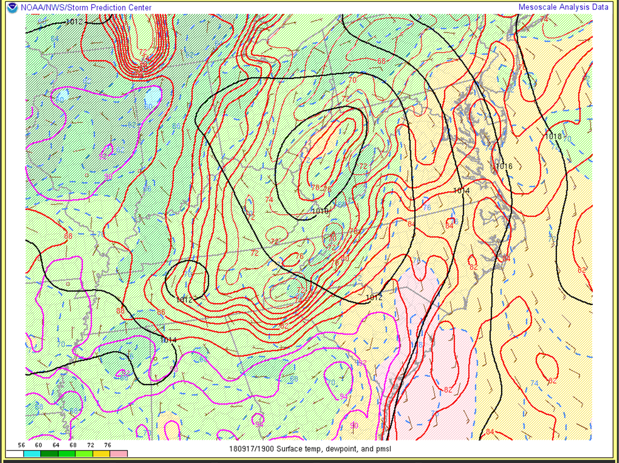
| Figure 1: 3 PM MSLP, Temperatures, and Dewpoints | Figure 2: 3 PM 925hPa Analysis | Figure 3: 2 PM KRIC NAM Analysis Sounding/Hodograph |
10 AM Environmental Snapshot (around the time of the Boydton tornado).
 |
 |
| Figure 4: 10 AM Surface Based CAPE | Figure 5: 10 AM SFC-1km Storm Relative Helicity |
3 PM Environmental Snapshot (Around the time of the tornadoes in the Richmond metro)
 |
 |
| Figure 6: 3 PM Surface Based CAPE | Figure 7: 3 PM SFC-1km Storm Relative Helicity |
 |
Media use of NWS Web News Stories is encouraged! Please acknowledge the NWS as the source of any news information accessed from this site. |
|


 Coastal Flood
 Heat
Heat