
Heavy to excessive rainfall is forecast over north Texas into Oklahoma Tuesday. Locally catastrophic flooding will be possible across portions of southwest Oklahoma. Flood Watches have been issued. Scattered severe thunderstorms are possible within a broad swath from the lower Great Lakes to the southern High Plains Tuesday afternoon into the evening. Read More >
Overview
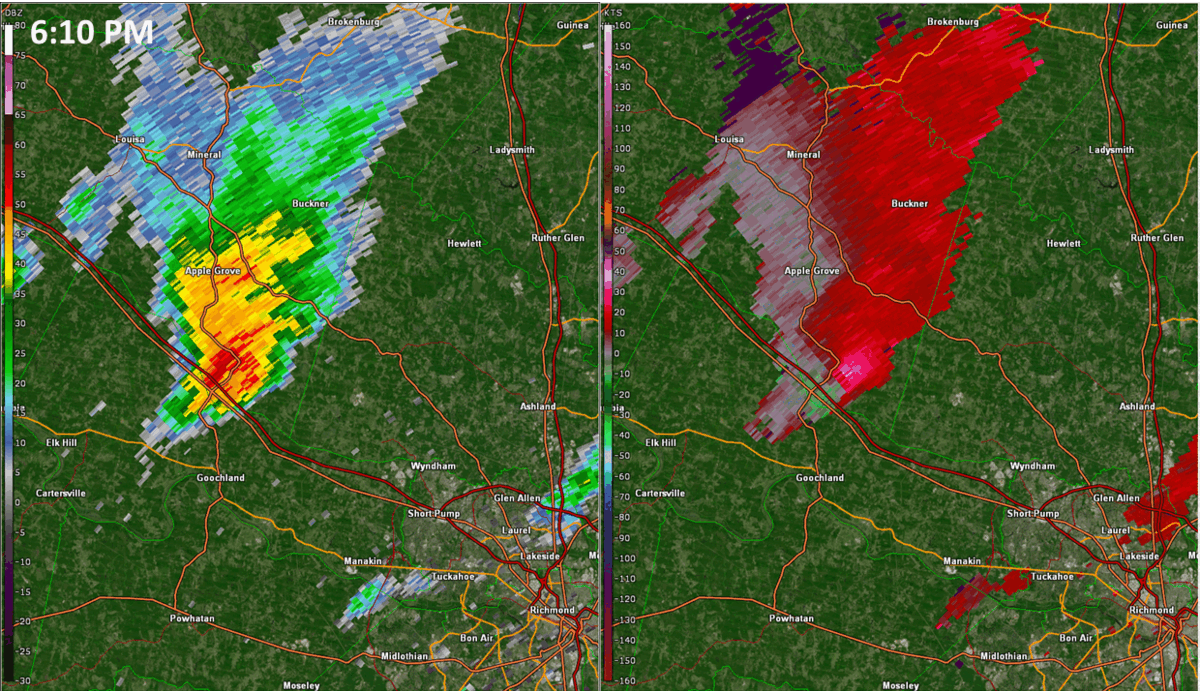
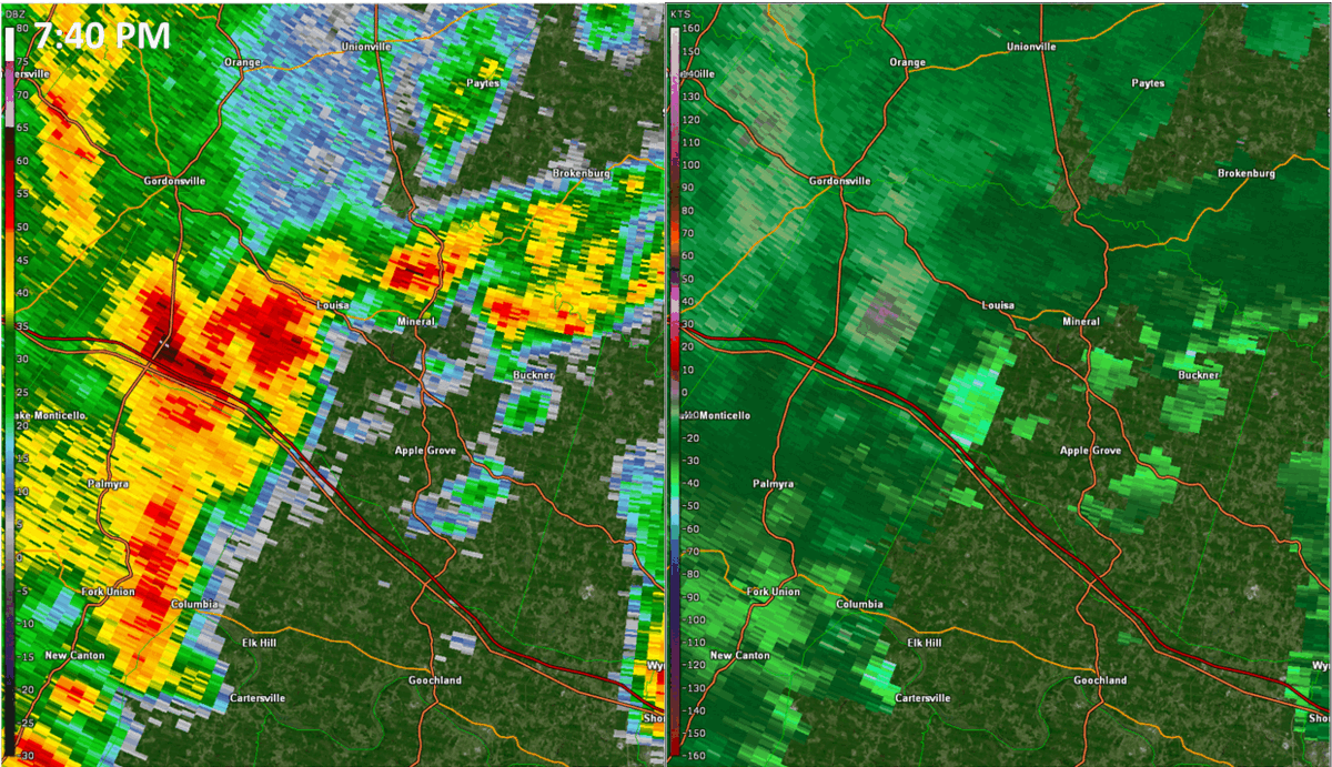
An upper level trough approached the local area during the night of 5/26 and early morning of 5/27. At the surface, a weak cold front slowly approached from the west as ~1002mb low pressure tracked across the Great Lakes. A line of thunderstorms (well in advance of the cold front) was just to the west of the local area at 7 AM on 5/28. This line likely maintained its strength through the previous night given strong lift from robust height falls on the east side of the upper trough. The line of storms tracked across the area from west to east from the morning through early afternoon hours on 5/28. Strong to severe wind gusts and transient circulations accompanied the line of storms as it tracked across the area. In fact, a 50 knot (58 mph) wind gusts was recorded at Richmond International Airport as the line of storms passed through during the late morning. The environment was characterized by modest instability and relatively strong deep layer shear. Even though winds at the surface were S-SE, the lack of moderate to strong instability (as the line of storms crossed the area during the morning) and diurnal weakening of the 950-900 mb winds likely was enough to prevent tornadoes from forming. In addition, there was not a whole lot of directional wind shear from 0-1 km AGL. The atmosphere briefly stabilized after the line passed through, but partial clearing over western portions of the area allowed for instability to increase by late afternoon. 21z/5 PM manual surface analysis revealed a ~1007mb secondary triple point low centered over the south-central VA Piedmont, just ahead of the main cold front. Some localized backing of the surface wind field was observed as this secondary low tracked NNE during the evening hours. In addition, dew points increased to around 70F area-wide as the 950-850mb jet strengthened from 5 PM-8 PM (21-00z). This allowed for an increase in 0-1 km speed/directional shear, with low-level SRH values likely between 100 and 200 m2/s2. Given the aforementioned shear/instability, lowering LCLs, and presence of the triple point low, two of the storms were able to produce two tornadoes (one EF-1 and one EF-0) that resulted in tree and isolated structural damage in portions of Louisa/Hanover Counties. All severe weather came to an end by 10 PM.Tornadoes:
|
Tornado - Dabneys to Beaverdam
Track Map 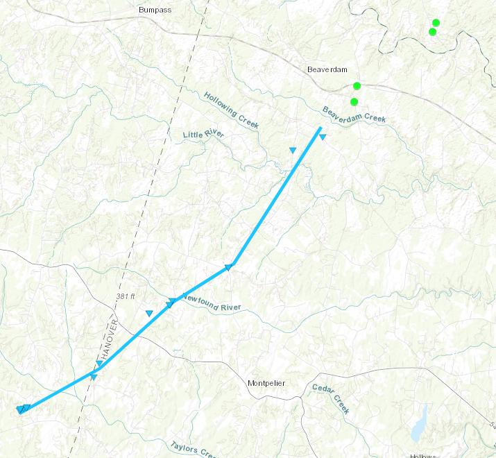 
|
||||||||||||||||
|
Tornado - Yanceyville to 3 miles SSE of the Louisa Airport
Track Map 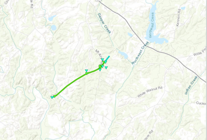
|
||||||||||||||||
The Enhanced Fujita (EF) Scale classifies tornadoes into the following categories:
| EF0 Weak 65-85 mph |
EF1 Moderate 86-110 mph |
EF2 Significant 111-135 mph |
EF3 Severe 136-165 mph |
EF4 Extreme 166-200 mph |
EF5 Catastrophic 200+ mph |
 |
|||||
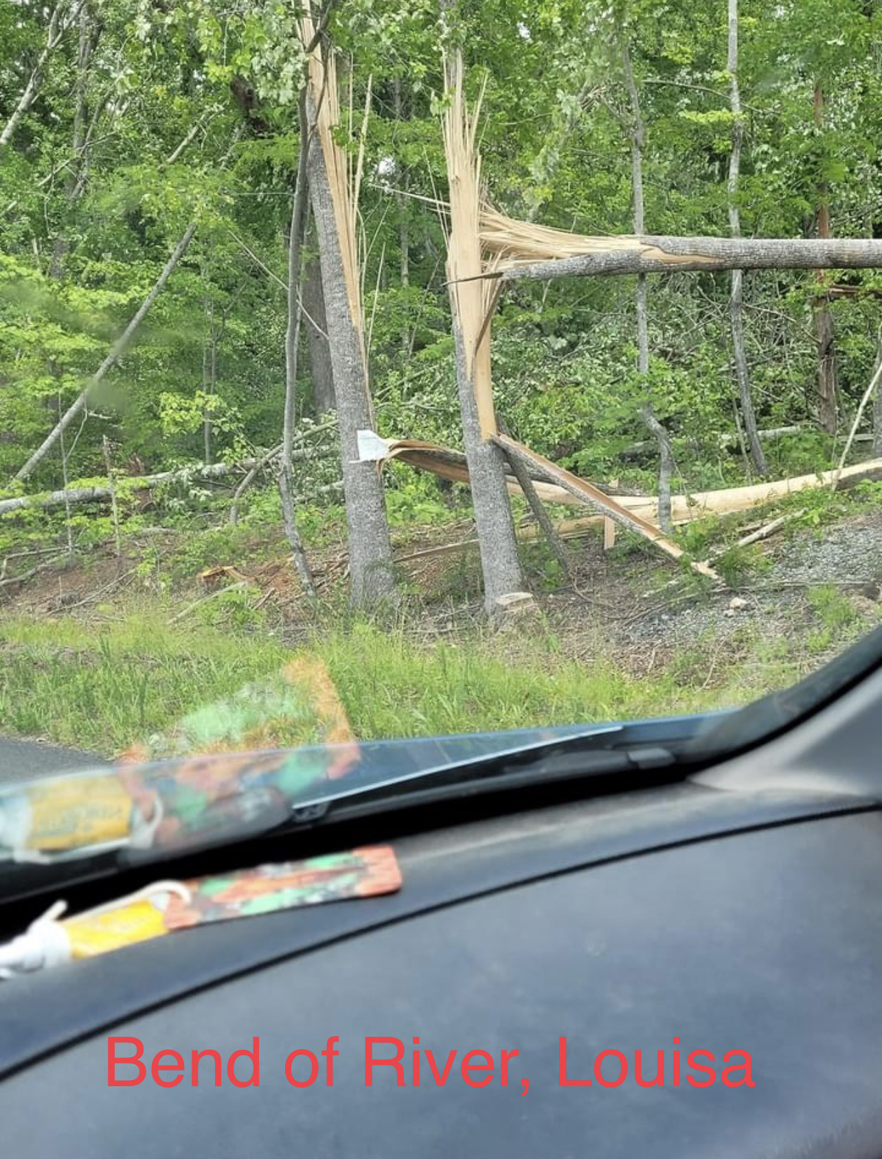
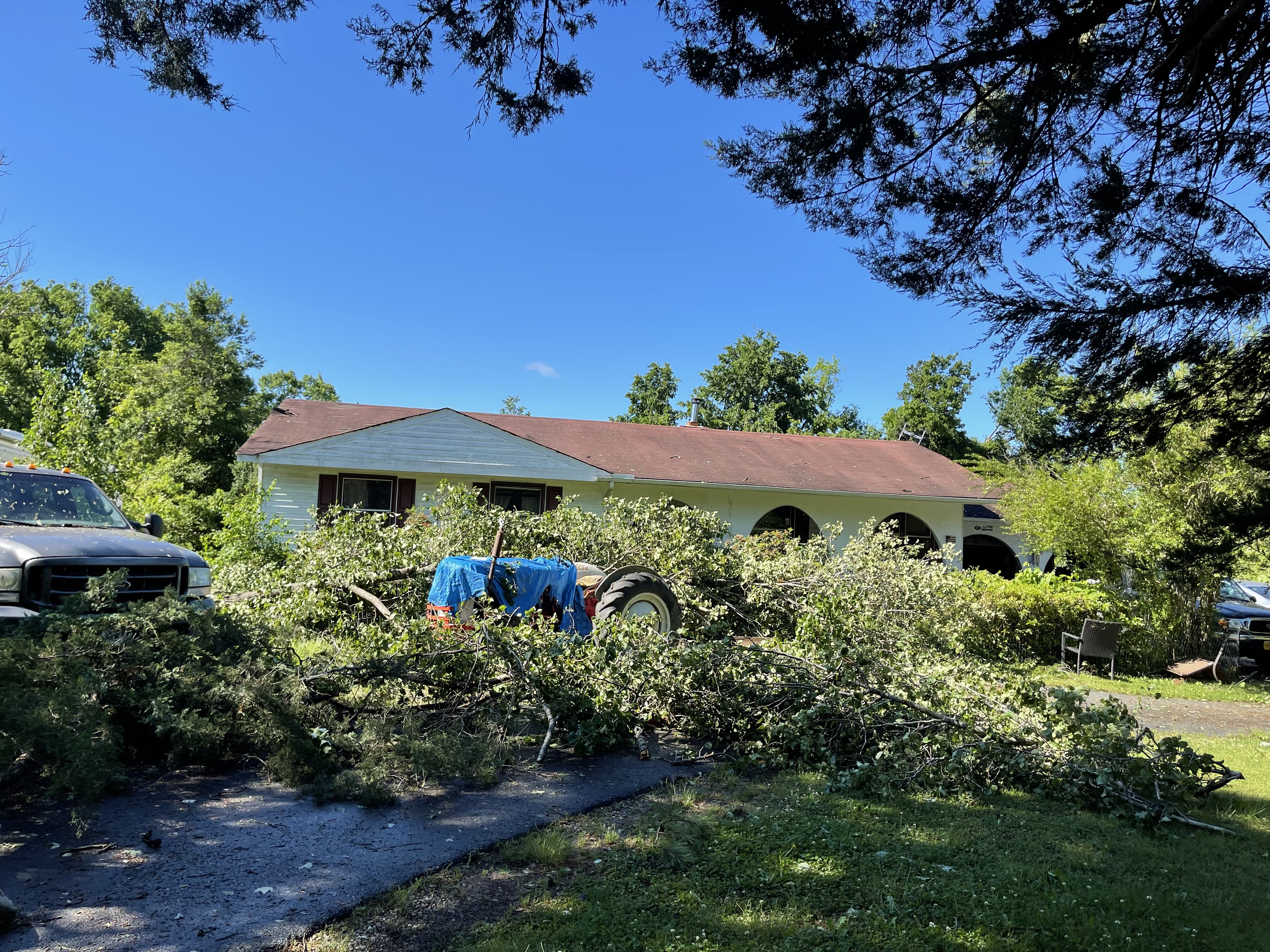
Photos
Selected Storm Damage Photos from Louisa County
 |
 |
 |
 |
| Credit: Angela Wesbey | Credit: Angela Wesbey | Credit: Angela Wesbey | Credit: Angela Wesbey |
Radar
Selected Radar Loops
 |
 |
| Radar loop of KAKQ 0.5 degree reflectivity/base velocity from approximately 6-7 PM. Note that the rotation was fairly broad, and that the strongest rotation on radar appeared after the tornado had lifted. | Radar loop of KLWX 0.5 degree reflectivity/base velocity from approximately 735-8 PM, highlighting the other tornado producing storm that tracked across Louisa County. Note that the lowest volume scan available for this area is 6000-6500 ft AGL. In addition, the circulation that was associated with the EF-1 tornado was very short-lived. |
Storm Reports
0955 AM     TSTM WND DMG     1 N TRENTS MILL         37.56N 78.29W
05/27/2022                   CUMBERLAND         VA   UTILITY COMPANY

            BROKEN UTILITY POLE. TIME ESTIMATED FROM
            RADAR.
1027 AM     TSTM WND DMG     1 SSW ELK HILL          37.70N 78.10W
05/27/2022                   CUMBERLAND         VA   LAW ENFORCEMENT

            MULTIPLE TREES DOWN ALONG AMPTHILL RD.
1059 AM     TSTM WND DMG     COLUMBIA                37.75N 78.16W
05/27/2022                   CUMBERLAND         VA   LAW ENFORCEMENT

            TREES DOWN NEAR COLUMBIA.
1135 AM     TSTM WND DMG     1 ENE COLONIAL HEIGHTS  37.27N 77.38W
05/27/2022                   CITY OF COLONIAL HEVA   EMERGENCY MNGR

            LARGE TREE FELL AND CRUSHED THE ROOF OF A
            HOUSE.
1142 AM     TSTM WND GST     1 N RICHMOND INTERNATIO 37.52N 77.32W
05/27/2022  M58 MPH          HENRICO            VA   ASOS

            ASOS STATION KRIC RICHMOND INTL AIRPORT.
1203 PM     TSTM WND DMG     3 SE STUDLEY            37.65N 77.24W
05/27/2022                   HANOVER            VA   DEPT OF HIGHWAYS

            TREES DOWN.
1222 PM     TSTM WND DMG     1 NE AHOSKIE            36.30N 76.98W
05/27/2022                   HERTFORD           NC   PUBLIC

            TREES AND LARGE LIMBS DOWN IN N AHOSKI.
1240 PM     TSTM WND DMG     GATES                   36.50N 76.77W
05/27/2022                   GATES              NC   PUBLIC

            TREES AND LARGE DOWN NEAR GATES.
0124 PM     MARINE TSTM WIND 1 WSW KIPTOPEKE STATE P 37.17N 75.99W
05/27/2022  M69 MPH          NORTHAMPTON        VA   BUOY

            BUOY STATION KPTV2 KIPTOPEKE, VA.
0135 PM     TSTM WND DMG     3 W LINKWOOD            38.54N 76.00W
05/27/2022                   DORCHESTER         MD   911 CALL CENTER

            TREE DOWN ON ROAD. TIME ESTIMATED FROM
            RADAR.
0622 PM     TORNADO          3 N DABNEYS             37.81N 77.80W
05/27/2022                   LOUISA             VA   PUBLIC

            TREES UPROOTED AND SNAPPED. LARGE CHICKEN
            COOP THROWN APPROXIMATELY 100 YARDS.
            POSSIBLE TORNADO. TIME ESTIMATED FROM RADAR.
0638 PM     TORNADO          3 ENE MABELTON          37.86N 77.70W
05/27/2022                   HANOVER            VA   EMERGENCY MNGR

            BUILDINGS AND A HOME DAMAGED IN ADDITION TO
            NUMEROUS TREES SNAPPED.
0641 PM     TSTM WND DMG     1 NNE MABELTON          37.85N 77.74W
05/27/2022                   HANOVER            VA   DEPT OF HIGHWAYS

            CORRECTS PREVIOUS TSTM WND DMG REPORT FROM 1
            NNE MABELTON. TREES REPORTS DOWN ALONG GUM
            BARREL RD, MABELTON RD AND PEASANT HILL RD.
0654 PM     TSTM WND DMG     1 NW CEDAR FORK         37.98N 77.57W
05/27/2022                   CAROLINE           VA   911 CALL CENTER

            REPORT OF MULTIPLE TREES AND POWER LINES
            DOWN IN THE JERICHO ROAD AREA. DAMAGE MAY BE
            DUE TO POSSIBLE TORNADO. TIME ESTIMATED FROM
            RADAR.
0703 PM     TSTM WND DMG     FLAT ROCK               37.52N 77.82W
05/27/2022                   POWHATAN           VA   NWS EMPLOYEE

            TREES DOWN ALONG HIGHWAY 60.
0715 PM     TSTM WND DMG     2 NNW WILMINGTON        37.88N 78.22W
05/27/2022                   FLUVANNA           VA   911 CALL CENTER

            TREE DOWN ON ROAD NEAR GEORGES MILL ROAD AND
            RISING SUN ROAD.
0737 PM     TSTM WND DMG     2 W PORT ROYAL          38.17N 77.22W
05/27/2022                   CAROLINE           VA   DEPT OF HIGHWAYS

            TREES DOWN.
0754 PM     TSTM WND DMG     3 S LOUISA AIRPORT      37.97N 77.97W
05/27/2022                   LOUISA             VA   LAW ENFORCEMENT

            POWER POLE BROKEN AND SHEDS TIPPED OVER AT
            THE END OF WESTBY DR. POSSIBLE TORNADO.
0755 PM     TSTM WND DMG     3 SSE LOUISA AIRPORT    37.97N 77.96W
05/27/2022                   LOUISA             VA   BROADCAST MEDIA

            PICTURES OF TREES SNAPPED ALONG MT. AIRY
            ROAD. POSSIBLE TORNADO.
0800 PM     TSTM WND DMG     1 NNE YANCEYVILLE       37.94N 77.98W
05/27/2022                   LOUISA             VA   911 CALL CENTER

            REPORTS OF MULTIPLE TREES DOWN IN THE
            YANCEYVILLE ROAD AND MOUNT AIRY ROAD AREA.
Environment
Synoptic Summary.
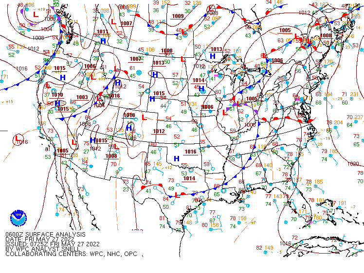 |
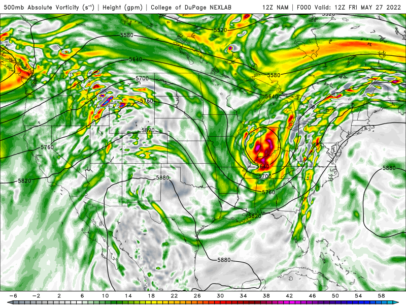 |
| Loop of WPC Surface Analysis from 06z/2 AM on 5-27 to 12z/8 AM on 5-28 | Loop of 12z/27 NAM Forecast 500mb Heights/Vorticity from 8 AM to 8 PM on 5/27 |
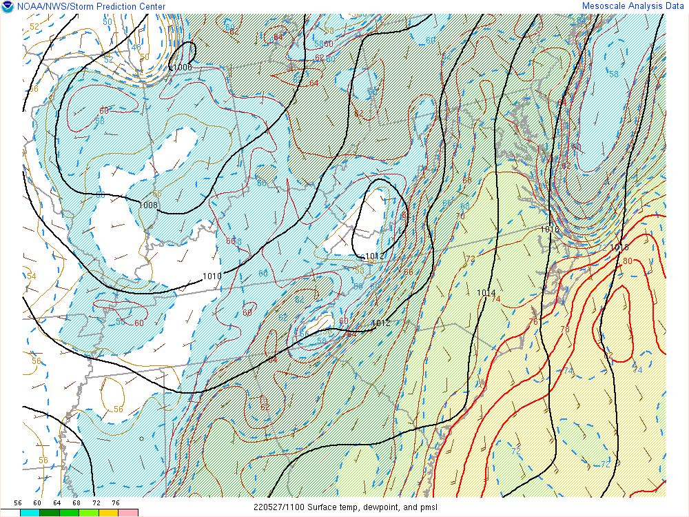
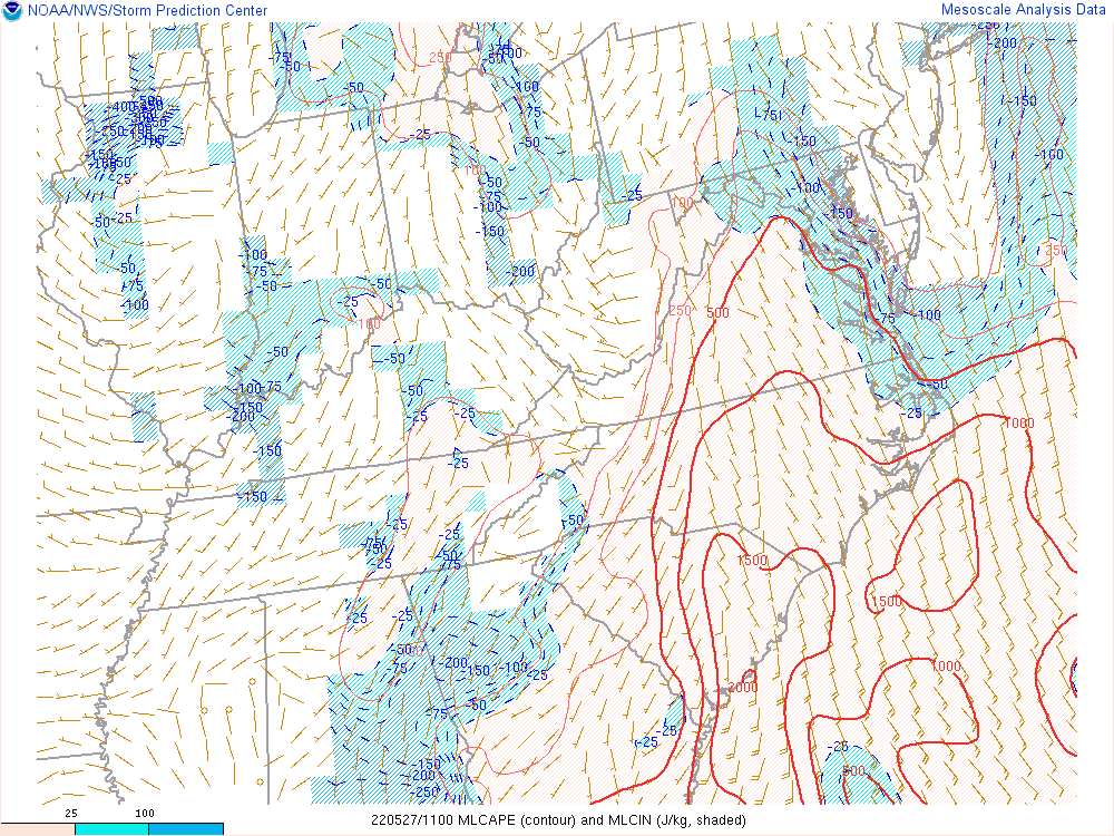
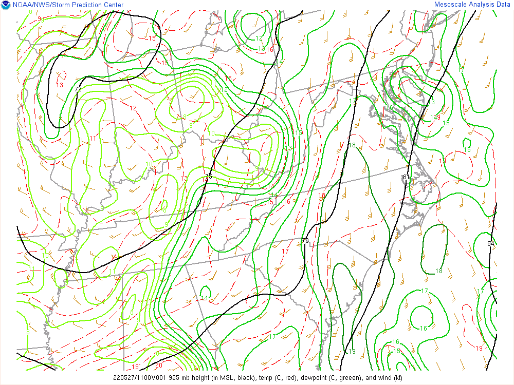
Selected Regional Mesoanalysis/Observation Data.
 |
 |
 |
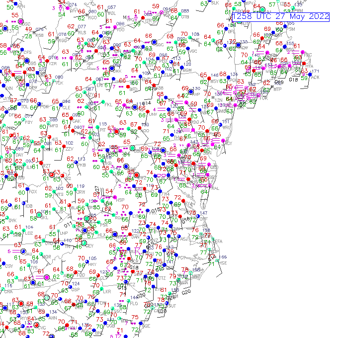 |
| Loop of T/Td/MSLP/Wind from 8 AM to 9 PM on 5/27 | Loop of MLCAPE/MLCIN from 8 AM to 9 PM on 5/27 | Loop of 925mb Analysis from 8 AM to 9 PM on 5/27 | Loop of Regional Observations from 8 AM to 9 PM on 5/27 |
Selected Near Storm Soundings.
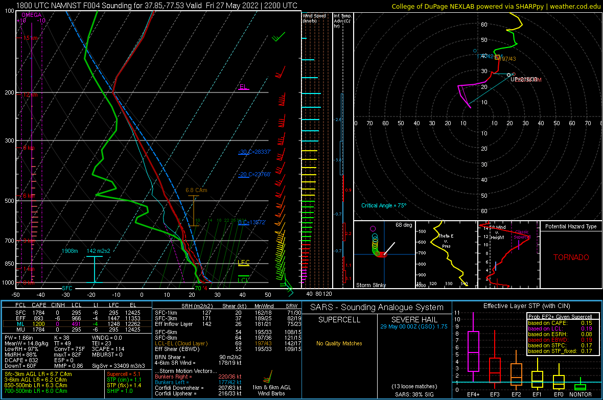 |
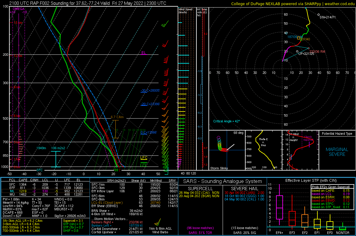 |
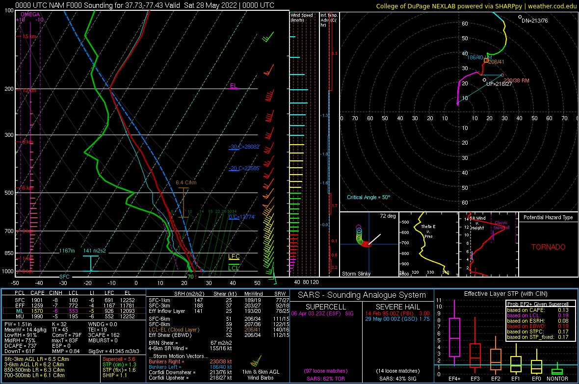 |
| 22z NAMNest Sounding near KOFP | 23z RAP Sounding near KOFP | 00z NAM Analysis Sounding near KOFP |
 |
Media use of NWS Web News Stories is encouraged! Please acknowledge the NWS as the source of any news information accessed from this site. |
|


 Coastal Flood
 Heat
Heat