Overview
Low pressure tracked eastward across southern portions of the Ohio Valley during the day on March 18th while a warm front that started the day over northern South Carolina moved northward toward the local area. This warm front would serve as the focal point for much of the severe weather observed across Virginia as well as North Carolina during the late afternoon through evening on the 18th. By around 4-5 PM, the warm front made it to a Greensboro (NC)-South Hill-Wakefield-Williamsburg line before stalling. A strong cold front remained well to our north through the evening. A line of (initially) elevated convection formed across western NC during the early afternoon. This line moved eastward into the North Carolina Piedmont and one of the cells produced a tornado near High Point, NC (just SW of Greensboro). Meanwhile, a cluster of hail producing rotating cells formed across south-central/interior portions of SE Virginia (in the Wakefield CWA) by 5 PM. While these prompted both Tornado and Severe Thunderstorm Warnings from Emporia, VA to Hampton Roads, only severe hail (up to half dollar size) and a little but of straight line wind damage was observed.
However, the aforementioned line of convection entered western portions of the Wakefield CWA by around 7:30 PM. Initially, the convection was all elevated given that the warm front had not moved to the NW of Greensville/Brunswick Counties. That line of convection traversed the Wakefield CWA during the next few hours. The southernmost cell in the line roughly followed the warm front, and it produced 1 tornado in Walters, VA (in far southern Isle of Wight County) and one area of 65-85 mph straight line winds in Northampton County, NC. This was likely due to the enhanced low-level directional shear (and thus Effective SRH) near and just south of the warm front. See "Environment" section for images. Additionally the tornado in the Wakefield CWA (and the one in High Point, NC) occurred near the greatest temperature/instability gradient (associated with the warm front). While environmental parameters seemed favorable for severe weather (and tornadoes) to our SE, no severe weather occurred deep in the warm sector across eastern and SE North Carolina. This was likely due to a lack of forcing in the warm sector. Quite a few of our past severe weather cases feature reports clustered along an instability gradient/front.
Tornado and Significant Straight Line Wind Damage:
|
Tornado - Walters, VA
Track Map  
|
||||||||||||||||
|
Straight Line Wind Damage- near Garysburg, NC
Track Map 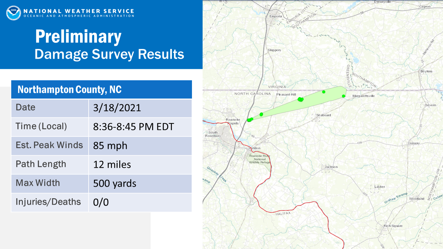
|
||||||||||||||
The Enhanced Fujita (EF) Scale classifies tornadoes into the following categories:
| EF0 Weak 65-85 mph |
EF1 Moderate 86-110 mph |
EF2 Significant 111-135 mph |
EF3 Severe 136-165 mph |
EF4 Extreme 166-200 mph |
EF5 Catastrophic 200+ mph |
 |
|||||
Photos
NWS Storm Survey Photos
 |
 |
 |
| Tornado Damage in Walters, VA (source: NWS Storm Survey) |
Tornado Damage in Walters, VA (source: NWS Storm Survey) |
Garysburg, NC straight line wind damage (source: NWS Storm Survey) |
Selected Radar Images
Loop from 9:15 to 9:37 PM of Walters Tornado
 |
| Loop of 0.5° Base Reflectivity (left) and Base Velocity (right). Note that the circulation that was responsible for the EF-0 tornado in Walters (circled) strengthened and weakened very quickly (in the timespan of a few minutes). |
Storm Reports
0550 PM     TSTM WND DMG     DREWRYVILLE             36.71N 77.30W
03/18/2021                   SOUTHAMPTON        VA   911 CALL CENTER

            TREES DOWN JUST NORTH OF HIGHWAY 258.
0555 PM     TSTM WND DMG     BETHEL CHURCH           36.96N 76.71W
03/18/2021                   ISLE OF WIGHT      VA   NWS EMPLOYEE

            TREES DOWN NEAR RECYCLE CENTER ON FOURSQUARE
            RD.
0559 PM     HAIL             CAPRON                  36.72N 77.20W
03/18/2021  E1.00 INCH       SOUTHAMPTON        VA   PUBLIC
0603 PM     HAIL             1 WNW MOGARTS BEACH     37.03N 76.61W
03/18/2021  E1.00 INCH       ISLE OF WIGHT      VA   PUBLIC
0609 PM     HAIL             1 NE BEACONSDALE        37.08N 76.45W
03/18/2021  M1.00 INCH       CITY OF NEWPORT NEWVA   TRAINED SPOTTER

            NICKEL TO QUARTER SIZE HAIL IS CURRENTLY
            FALLING.
0615 PM     HAIL             2 SW POQUOSON           37.11N 76.42W
03/18/2021  M1.25 INCH       YORK               VA   PUBLIC
0617 PM     HAIL             3 W LANGLEY AFB         37.09N 76.42W
03/18/2021  M1.75 INCH       CITY OF HAMPTON    VA   PUBLIC

            REPORT VIA TWITTER. TIME ESTIMATED FROM
            RADAR.
0618 PM     HAIL             2 SE TABB               37.11N 76.43W
03/18/2021  M1.00 INCH       YORK               VA   PUBLIC

            REPORT VIA TWITTER.
0622 PM     HAIL             LANGLEY AFB             37.08N 76.37W
03/18/2021  M1.00 INCH       CITY OF HAMPTON    VA   PUBLIC

            REPORT VIA TWITTER.
0625 PM     HAIL             1 WNW HALLWOOD          37.07N 76.32W
03/18/2021  M1.25 INCH       CITY OF HAMPTON    VA   TRAINED SPOTTER
0830 PM     TSTM WND DMG     3 E GASTON              36.49N 77.59W
03/18/2021                   NORTHAMPTON        NC   LAW ENFORCEMENT

            DAMAGE TO A BARN ON BLYTHE ROAD. TIME
            ESTIMATED BY RADAR.
1012 PM     TSTM WND DMG     1 SSW NORVIEW           36.88N 76.25W
03/18/2021                   CITY OF NORFOLK    VA   UTILITY COMPANY

            TREE DOWN ON POWER LINE CAUSING MULTIPLE
            POWER OUTAGES NEAR THE INTERSECTION OF ROUTE
            247 AND ROBIN HOOD ROAD. TIME ESTIMATED FROM
            RADAR.
Environment
Insert synoptic summary.
 |
 |
 |
 |
| 18z/2 PM EDT 3/18 WPC Surface Analysis | 21z/5 PM EDT 3/18 WPC Surface Analysis | 00z/8 PM EDT 3/18 WPC Surface Analysis | 03z/11 PM EDT 3/18 WPC Surface Analysis |
Near-storm environment summary.
 |
 |
 |
|
| 18z/2 PM T/Td/MSLP | 21z/5 PM T/Td/MSLP | 00z/8 PM T/Td/MSLP | 02z/10 PM T/Td/MSLP |
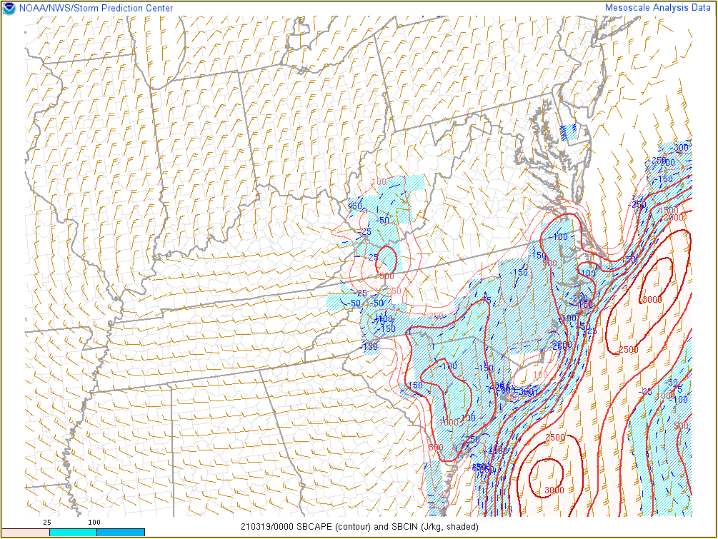
Additional Environmental Data.
 |
 |
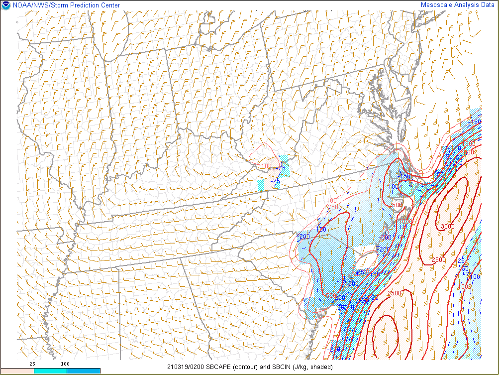 |
| 21z/5 PM SBCAPE/CIN | 00z/8 PM SBCAPE/CIN | 02z/10 PM SBCAPE/CIN |
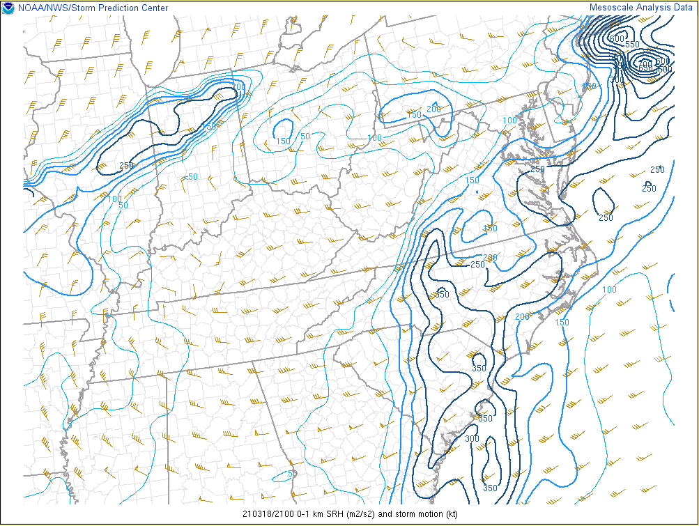
Additional environmental data.
 |
 |
 |
| 21z/5 PM 0-1 km SRH | 00z/8 PM 0-1 km SRH | 02z/10 PM 0-1 km SRH |
 |
Media use of NWS Web News Stories is encouraged! Please acknowledge the NWS as the source of any news information accessed from this site. |
|


 Coastal Flood
 Heat
Heat