Overview
An upper shortwave ejected ENE into the central High Plains the morning before the event (1/30). That shortwave continued tracking east-northeastward through the Plains during the day on the 30th. The associated strong surface low followed an east-northeast track through the Plains as well. Meanwhile, a cold Canadian airmass was in place over much of the eastern US. During the night of the 30th into the early morning hours of the 31st, the upper shortwave formed into an upper low as it continued tracking ENE as the parent surface low approached the central Appalachians. Clouds were already on the increase over the local area by early Sunday morning with temperatures at just below freezing area-wide. A leading band of snow associated with mid-level (700-500 mb) frontogenetical forcing was right at our western CWA border by 06z/1 AM on the 31st.
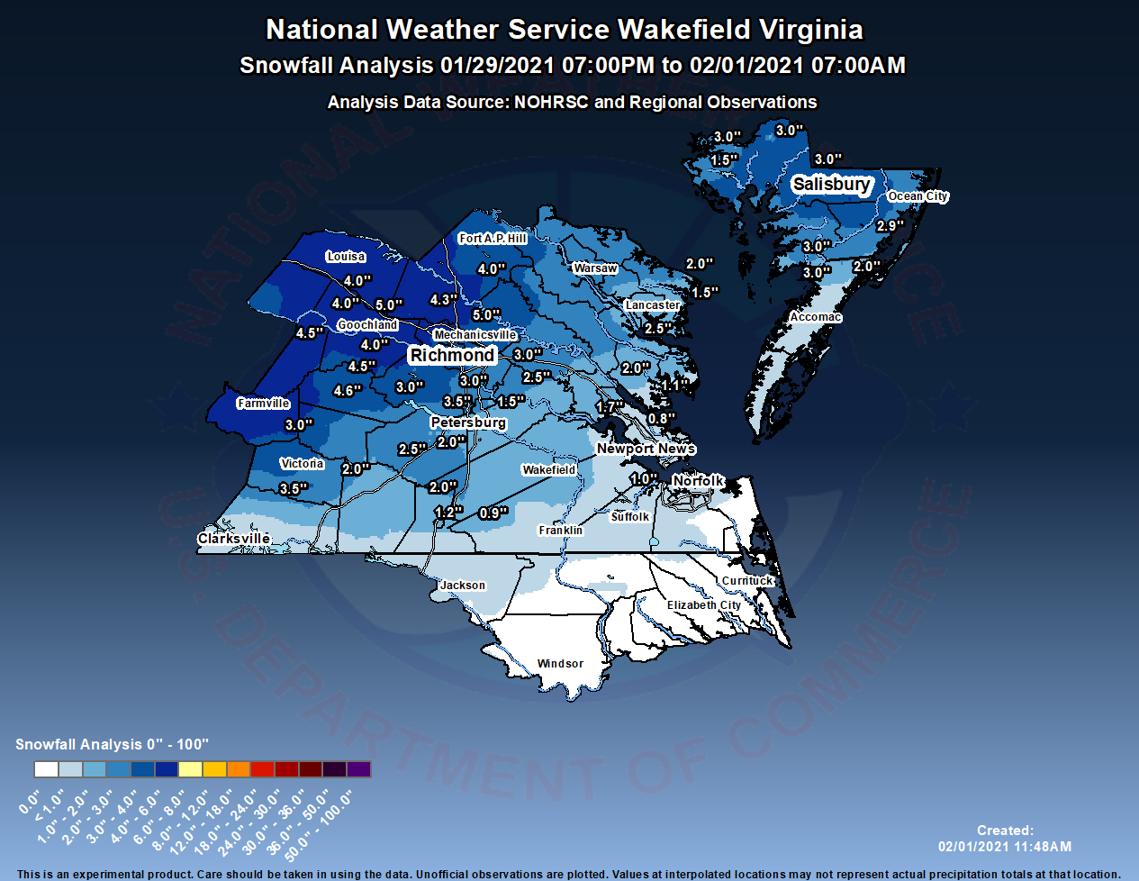
During the remainder of the morning on the 31st, a secondary surface low started to develop along a stalled warm front well to our south as the parent low dissipated as it approached the mountains (classic "Miller-B" setup). High pressure centered from just south of the Hudson Bay to near Burlington, VT was ridging south into the area, helping to create a cold air damming situation. A more substantial area of precipitation moved into the area from W-E between 5 and 8 AM. Thermal profiles were still cold enough for this to be all snow at the onset (even down to Norfolk/Chesapeake/VA Beach). However. strong warm air advection (especially from 925 to 700 mb) took hold during the day, and snow quickly changed to sleet, freezing rain, then rain from SSW to NNE. The snow was heaviest in the 30-60 minutes immediately preceding the transition to sleet/mixed precip. Fairly strong 850 mb frontogenesis was noted during the day on 1-31. No freezing rain was observed closer to the coast, where snow simply transitioned to sleet then rain. By late afternoon, precipitation had turned to rain in most areas, but remained freezing rain across our far NW counties (where CAD typically lasts the longest and temperatures failed to rise above freezing during the entirety of the event). In total, 1 to 2 inches of snow was common across south-central and interior SE VA, with 2-5" over the Richmond metro, and 4-6" (and some light icing) across our VA Piedmont counties. In some areas in the southern Richmond metro, this was the first accumulation of snow on roadways since December 2018.
Snowfall Totals
Photos & Video
Header
| Caption (source) |
Caption (source) |
Caption (source) |
Caption (source) |
Radar and Observations
Loops from early morning through afternoon
 |
 |
| Radar Loop from 06z/1 AM to 21z/4 PM in 3 hour increments | Loop of Observations from 06z/1 AM to 21z/4 PM in 3 hour increments |
Storm Reports
...SNOWFALL REPORTS...

Location                     Amount    Time/Date       Provider

...Maryland...

...Dorchester County...
East New Market              3.1 in    0345 PM 01/31   Cocorahs
2 ENE East New Market        3.0 in    0400 PM 01/31   Cocorahs
1 W Hurlock                  3.0 in    0327 PM 01/31   Public
Cambridge                    3.0 in    0307 PM 01/31   Emergency Mngr

...Somerset County...
2 S Marion Station           3.0 in    0331 PM 01/31   Cocorahs
2 SSW Princess Anne          3.0 in    0300 PM 01/31   Cocorahs
Marion Station               3.0 in    0136 PM 01/31   Trained Spotter
1 ENE Crisfield              2.6 in    0230 PM 01/31   Cocorahs

...Wicomico County...
2 E Lakewood                 3.7 in    0256 PM 01/31   Cocorahs
2 SSE Delmar                 3.5 in    0315 PM 01/31   Broadcast Media
Delmar                       3.0 in    0344 PM 01/31   Broadcast Media
1 SW Salisbury               3.0 in    0251 PM 01/31   Broadcast Media
1 E Fruitland                2.8 in    0255 PM 01/31   Public
Salisbury                    2.5 in    0157 PM 01/31   Public
Fruitland                    2.5 in    0147 PM 01/31   Public

...Worcester County...
5 SE Ironshire               3.0 in    0330 PM 01/31   Cocorahs
Snow Hill                    2.9 in    0427 PM 01/31   Broadcast Media

...Virginia...

...Accomack County...
2 NE Atlantic                2.0 in    0700 PM 01/31   CO-OP Observer

...Amelia County...
1 S Chula                    4.6 in    0954 AM 01/31   Public
2 S Deatonville              3.8 in    1000 AM 01/31   Cocorahs
Amelia Courthouse            3.5 in    0230 PM 01/31   CO-OP Observer

...Brunswick County...
3 SW Ordsburg                3.2 in    0830 AM 01/31   CO-OP Observer

...Caroline County...
2 S Dawn                     4.2 in    1130 AM 01/31   Cocorahs
Ladysmith                    4.0 in    1230 PM 01/31   Cocorahs
Penola                       4.0 in    1218 PM 01/31   Trained Spotter

...Charles City County...
2 N Barnetts                 2.5 in    1100 AM 01/31   Public

...Chesterfield County...
1 SW Midlothian              5.0 in    0104 PM 01/31   Trained Spotter
Midlothian                   4.0 in    1043 AM 01/31   NWS Employee
Bon Air                      3.9 in    1144 AM 01/31   Public
2 SSW Chesterfield           3.5 in    0950 AM 01/31   NWS Employee
2 WSW Meadowville            3.3 in    0943 AM 01/31   NWS Employee
2 SSE Bon Air                3.0 in    1030 AM 01/31   Public
Chester                      3.0 in    0923 AM 01/31   Public
5 NW Pocahontas State Park   3.0 in    0911 AM 01/31   Public
4 S Midlothian               3.0 in    0910 AM 01/31   Public
1 NW Drewrys Bluff           2.8 in    1117 AM 01/31   Public
Matoaca                      2.5 in    1015 AM 01/31   Public
1 SE Meadowville             2.5 in    0930 AM 01/31   NWS Employee
3 SSE Chester                2.5 in    0900 AM 01/31   NWS Employee
3 S Meadowville              2.3 in    0940 AM 01/31   NWS Employee
1 NE Centralia               2.0 in    0912 AM 01/31   Public
3 SSW Midlothian             2.0 in    0800 AM 01/31   Public

...City of Colonial Heights County...
1 NE Colonial Heights        2.5 in    1050 AM 01/31   NWS Employee

...City of Emporia County...
Emporia Reservoir            1.2 in    0700 AM 01/31   CO-OP Observer

...City of Franklin County...
Franklin                     0.8 in    0800 AM 01/31   Trained Spotter

...City of Hampton County...
1 E Hallwood                 0.4 in    0953 AM 01/31   Public

...City of Hopewell County...
2 SSW Hopewell               2.5 in    0915 AM 01/31   Public
1 ENE Hopewell               1.5 in    0400 PM 01/31   CO-OP Observer

...City of Newport News County...
1 SSE Newport News           0.7 in    1000 AM 01/31   Cocorahs

...City of Norfolk County...
Norfolk International Arpt   0.3 in    0100 PM 01/31   Official NWS Obs

...City of Richmond County...
2 SSE Lakeside               4.0 in    1130 AM 01/31   Trained Spotter
2 NNE Downtown Richmond      3.0 in    1127 AM 01/31   NWS Employee
2 SW Dumbarton               3.0 in    1013 AM 01/31   Public

...Cumberland County...
1 SSE Cartersville           4.5 in    1052 AM 01/31   Trained Spotter

...Dinwiddie County...
Dinwiddie                    2.5 in    1045 AM 01/31   Public

...Gloucester County...
Gloucester Courthouse        2.0 in    1050 AM 01/31   Public

...Goochland County...
Crozier                      4.0 in    0535 PM 01/31   CO-OP Observer
2 NE Tabscott                4.0 in    1005 AM 01/31   Public

...Greensville County...
Purdy                        2.0 in    0912 AM 01/31   Trained Spotter

...Hanover County...
2 S Vontay                   5.0 in    1152 AM 01/31   Public
1 NNE Ashcake                5.0 in    1047 AM 01/31   Public
3 N Gilman                   4.8 in    1200 PM 01/31   Cocorahs
Hewlett                      4.5 in    1230 PM 01/31   Cocorahs
1 SW Ashland                 4.3 in    1054 AM 01/31   CO-OP Observer
Rockville                    3.9 in    1056 AM 01/31   Public
1 ENE Mechanicsville         3.0 in    0933 AM 01/31

...Henrico County...
Short Pump                   5.0 in    1130 AM 01/31   Trained Spotter
3 N Short Pump               4.5 in    1100 AM 01/31   Public
2 N Short Pump               4.3 in    1042 AM 01/31   Public
1 ESE Longdale               4.0 in    1111 AM 01/31   Trained Spotter
Glen Allen                   4.0 in    1100 AM 01/31   Public
2 NNE Tuckahoe               3.5 in    1020 AM 01/31   Broadcast Media

...Isle of Wight County...
2 SE Smithfield              1.0 in    0921 AM 01/31   NWS Employee

...James City County...
Jamestown                    1.7 in    0950 AM 01/31   Trained Spotter
Five Forks                   1.3 in    1000 AM 01/31   Cocorahs

...King William County...
1 N West Point               2.1 in    1000 AM 01/31   CO-OP Observer

...Lancaster County...
Mollusk                      1.7 in    1115 AM 01/31   Cocorahs

...Louisa County...
1 NNW Louisa                 4.5 in    0600 PM 01/31   CO-OP Observer
3 WNW Orchid                 4.0 in    1037 AM 01/31   Public

...Lunenburg County...
2 NE Gary                    3.5 in    0800 AM 01/31   Public
1 W Lunenburg                2.5 in    0800 AM 01/31   Public
Dundas                       2.0 in    0933 AM 01/31   Public

...Mathews County...
2 S Fort Nonsense            1.1 in    0500 PM 01/31   CO-OP Observer

...Middlesex County...
Cooper                       2.5 in    1200 PM 01/31   Public

...New Kent County...
Bottoms Bridge               3.0 in    1030 AM 01/31   Trained Spotter
Barhamsville                 1.3 in    0844 AM 01/31   Public

...Northumberland County...
2 NW Opheila                 2.0 in    0134 PM 01/31   Public
2 NNE Lottsburg              2.0 in    0130 PM 01/31   Cocorahs
1 WNW Fair Port              1.5 in    1220 PM 01/31   Utility Company
2 E Howland                  1.5 in    1200 PM 01/31   Cocorahs

...Powhatan County...
Genito                       4.5 in    1035 AM 01/31   Public
3 SSE Fine Creek Mills       4.5 in    1025 AM 01/31   Public
Powhatan                     4.0 in    0940 AM 01/31   Public

...Prince Edward County...
1 SSW Farmville              5.2 in    1000 AM 01/31   Cocorahs
Farmville                    4.0 in    0920 AM 01/31   Public
Green Bay                    3.0 in    0800 AM 01/31   Public

...Prince George County...
2 NNE Reams                  2.0 in    1126 AM 01/31   NWS Employee
2 ENE Reams                  2.0 in    1124 AM 01/31   NWS Employee
2 SSE Fort Lee               2.0 in    0939 AM 01/31   NWS Employee
1 W Prince George            2.0 in    0900 AM 01/31   NWS Employee
1 N Prince George Golf       1.5 in    0925 AM 01/31   NWS Employee
Disputanta                   1.3 in    0910 AM 01/31   Public

...Southampton County...
2 S Berlin                   1.0 in    0900 AM 01/31   Cocorahs
2 SW Drewryville             0.9 in    0928 AM 01/31   Cocorahs

...Sussex County...
1 NW Wakefield               1.4 in    0849 AM 01/31   Official NWS Obs

...York County...
Grafton                      0.8 in    0938 AM 01/31   Public
&&
Environment
Upper Level synoptic summary.
 |
 |
 |
| 12z/7 AM 1-30-21 500 mb analysis | 12z/7 AM 1-31 500 mb analysis | 12z/7 AM 2-1 500 mb analysis |
Surface synoptic summary.
 |
 |
 |
 |
| 00z/7 PM 1-30 WPC Surface Analysis | 12z/7 AM 1-31 WPC Surface Analysis | 00z/7 PM 1-31 WPC Surface Analysis | 12z/7 AM 2-1 WPC Surface Analysis |
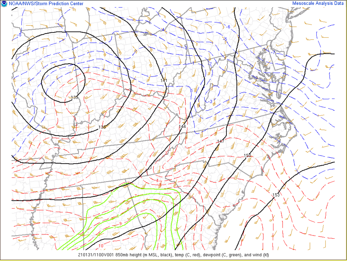
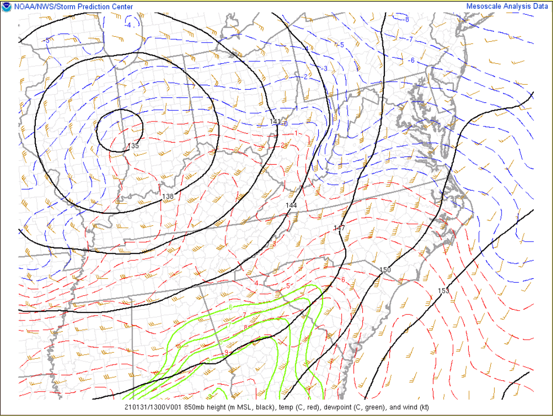
1/31/2021 850 mb Mesoanalysis...note the progression of the H85 freezing line.
 |
 |
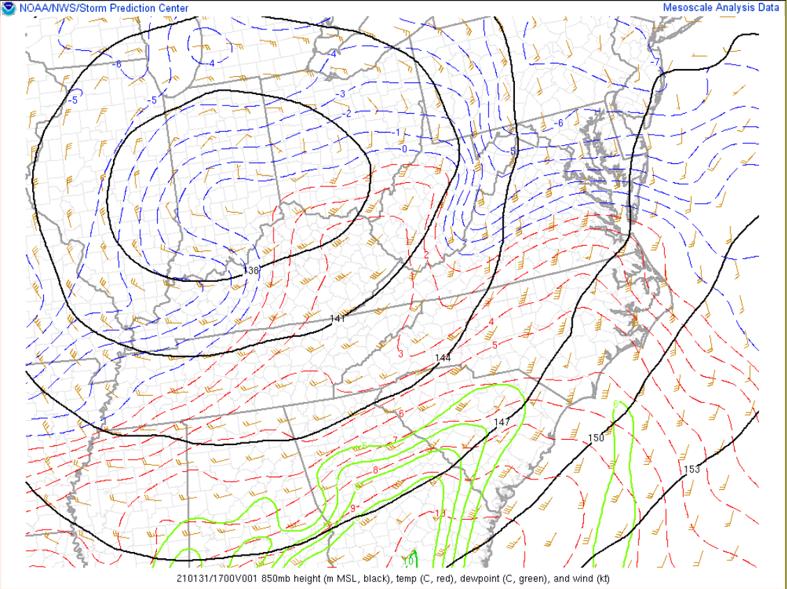 |
| 12z/7 AM 850 mb temperature/dew point/height/wind | 14z/9 AM 850 mb temperature/dew point/height/wind | 18z/2 PM 850 mb temperature/dew point/height/wind |
 |
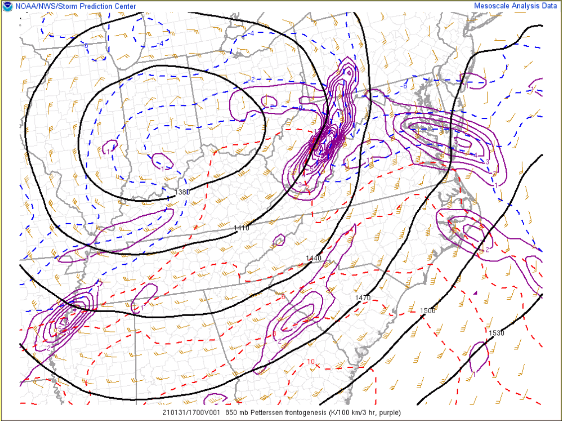 |
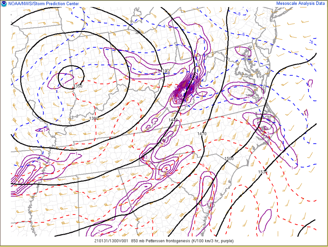
| 14z/9 AM 850 mb Frontogenesis | 17z/noon 850 mb Frontogenesis |
 |
Media use of NWS Web News Stories is encouraged! Please acknowledge the NWS as the source of any news information accessed from this site. |
|


 Coastal Flood
 Heat
Heat