Overview
An Arctic cold front crossed the area during the late morning through afternoon hours on January 21st, before moving well to the south of the area by the morning of January 22nd. Up to 1" of snow fell from the late afternoon on 1/21 through the early morning on 1/22 following the Arctic cold frontal passage. Meanwhile, a positively tilted shortwave trough dropped south from the northern Plains to the central Plains during the night of 1/21 through the morning of 1/22. This feature played a key role in helping to generate the lift necessary for the significant snowfall that was observed. This shortwave slowly sharpened and took on a more neutral tilt as it tracked to the east (toward the local area) during the day on 1/22 as surface low pressure developed along the stalled front well to our south (off the Carolina coast).
The sharpening shortwave approached the area on 1/22 before crossing the area during the early morning hours on 1/23. At the surface, ~1040mb high pressure to our north funneled cold, dry Arctic air in the low levels toward our area while the surface low gradually deepened as it tracked NE off the Carolina coast. With temperatures not getting out of the 20s across the area during the day on 1/22 (and sufficiently cold air aloft), this was one of the uncommon events where precipitation fell in the form of snow across (nearly) the entire area. The cold, dry air in the low-levels limited snow amounts across central and northern portions of the area. No snow was reported north and west of the Richmond Metro/Farmville/Cambridge. Light snow overspread SE VA and NE NC during the late afternoon-evening of the 22nd. Rates slowly increased through the late evening hours as the snow gradually inched to the north and northwest (radar returns were showing snow aloft across the entire area but the dry air caused it to sublimate before reaching the ground). Travel conditions deteriorated quickly during the overnight hours, as the snow stuck to roads immediately with temperatures well below freezing (even in Hampton Roads/NE NC). The snow started to reach the ground by 10-11 PM in the Richmond metro area while rates increased further across SE VA and NE NC. The snow ended from west to east between 2 and 7 AM on 1/22 as the mid level shortwave quickly crossed the area. The most intense snowfall (perhaps 1-2"/hour in narrow bands) was observed between 11 PM and 5 AM across SE VA and NE NC, where there was slantwise instability present (as evidenced by negative equivalent potential vorticity (EPV). Model cross sections even showed some hints that there might have been some very weak elevated, upright instability across extreme SE VA and NE NC. While there was no thunder, a nearly stationary band of rates likely as high as 2"/hour was situated across NE NC (just to the north of the Elizabeth City) for a couple hours during the early morning. In addition, 1"/hour rates likely occurred at times in Hampton Roads. In total, amounts ranged from 1/4-1" in the Richmond Metro, 1-3" from south-central VA to eastern VA and most of the Lower Eastern Shore, and 3-7" (locally 8" just north of Elizabeth City) across Hampton Roads and most of NE NC. This was the most significant snowfall for much of SE VA and NE NC since January 2018!
Snow Report Map

Photos
Selected Photos
 |
 |
 |
 |
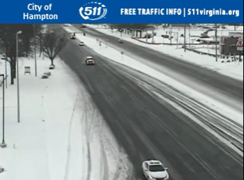
| Road Conditions in Hampton, VA around 8 AM on 1/22 (source: VDOT) |
Road Conditions in Chesapeake, VA around 8 AM on 1/22 (source: VDOT) |
Road Conditions in Virginia Beach, VA around 8 AM on 1/22 (source: VDOT) |
Road Conditions in Virginia Beach, VA around 8 AM on 1/22 (source: VDOT) |
Radar
Radar Loop
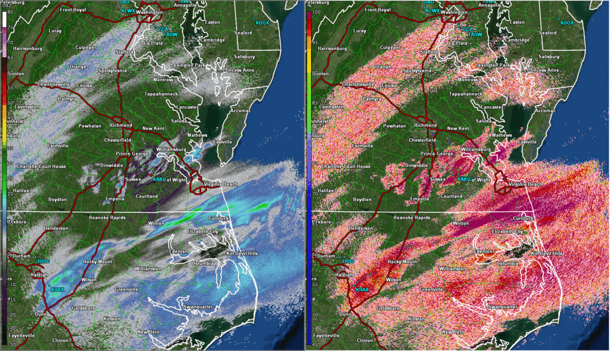 |
| Loop of 0.5° Reflectivity (left) and Correlation Coefficient (right) from 4 PM on 1/21 to 7 AM on 1/22 in ~30 minute increments. Note that the correlation coefficient product shows all snow across nearly the entire area (except for some mixing in NE NC near the Albemarle Sound). Note the band that developed and persisted for a couple of hours during the early morning just north of Elizabeth City (this is where we got the 8" reports). Selected local storm reports are overlaid. |
Snowfall Reports
Public Information Statement
National Weather Service Wakefield VA
711 AM EST Sun Jan 23 2022

...SNOWFALL REPORTS...

Location                     Amount    Time/Date       Provider

...Maryland...

...Somerset County...
1 ENE Crisfield              1.5 in    0830 AM 01/22   Cocorahs
Marion Station               1.5 in    1008 AM 01/22   Trained Spotter
2 SSW Princess Anne          1.4 in    0700 AM 01/22   Cocorahs

...Wicomico County...
Parsonsburg 1.6 WNW          1.0 in    0700 AM 01/22   COCORAHS
Salisbury                    1.0 in    0824 AM 01/22   Public

...Worcester County...
Ocean Pines 0.9 SSW          2.5 in    0700 AM 01/22   COCORAHS

...North Carolina...

...Bertie County...
Windsor                      4.0 in    1050 AM 01/22   Public

...Camden County...
South Mills                  7.0 in    1115 AM 01/22   Emergency Mngr
1 E Whitehall Shores         6.5 in    1115 AM 01/22   Emergency Mngr
Riddle                       6.0 in    0800 AM 01/22   Trained Spotter
Shiloh                       4.5 in    1115 AM 01/22   Emergency Mngr

...Chowan County...
3 S Somerset                 5.5 in    0800 AM 01/22   Park/Forest Srvc
2 SSW Somerset               5.0 in    0909 AM 01/22   Emergency Mngr

...Currituck County...
3 NNW Moyock                 7.0 in    0800 AM 01/22
Moyock 1.8 SSE               6.7 in    0700 AM 01/22   COCORAHS
Grandy 0.6 E                 6.5 in    0700 AM 01/22   COCORAHS
1 NNW Grandy                 6.0 in    0730 AM 01/22
Waterlily                    6.0 in    0804 AM 01/22   Broadcast Media
Corolla 5.8 SSE              5.2 in    0700 AM 01/22   COCORAHS
5 N Corolla                  3.0 in    0809 AM 01/22   Public
Point Harbor                 2.0 in    0700 AM 01/22   Public

...Hertford County...
1 NW Winton                  5.0 in    0916 AM 01/22   Emergency Mngr
1 WNW Ahoskie                4.5 in    1125 AM 01/22   Public
Murfreesboro                 3.5 in    1200 PM 01/22   Public

...Northampton County...
1 NW Rich Square             5.0 in    0800 AM 01/22   Public
Severn                       3.5 in    1205 PM 01/22   Public
Henrico                      2.5 in    0800 AM 01/22   Cocorahs

...Pasquotank County...
1 N Elizabeth City           8.0 in    1115 AM 01/22   Emergency Mngr
4 S Burnt Mills              8.0 in    1115 AM 01/22   Emergency Mngr
2 SW Lambs Corner            7.8 in    1115 AM 01/22   Emergency Mngr
Elizabeth City 7.7 SSW       7.0 in    0700 AM 01/22   COCORAHS
1 WNW Elizabeth City         6.5 in    1115 AM 01/22   Emergency Mngr
2 WSW Elizabeth City         6.5 in    1115 AM 01/22   Emergency Mngr
3 WNW Elizabeth City         6.5 in    1127 AM 01/22   Emergency Mngr
3 NW Elizabeth City          6.0 in    1115 AM 01/22   Emergency Mngr
2 SE Elizabeth City          6.0 in    1115 AM 01/22   Emergency Mngr
Elizabeth City 0.8 NW        5.2 in    0800 AM 01/22   COCORAHS
Elizabeth City 5.1 SSE       5.0 in    0700 AM 01/22   COCORAHS
1 NNE Lynchs Corner          5.0 in    1115 AM 01/22   Emergency Mngr
Elizabeth City               5.0 in    1115 AM 01/22   Emergency Mngr
Elizabeth City 11.7 WNW      3.8 in    0844 AM 01/22   COCORAHS

...Perquimans County...
Hertford 5.2 SSE             5.0 in    0700 AM 01/22   COCORAHS
1 NW Holiday Island          5.0 in    1000 AM 01/22   Trained Spotter
2 NE Burgess                 4.0 in    0822 AM 01/22
2 SE Winfall                 4.0 in    0917 AM 01/22

...Virginia...

...Accomack County...
Melfa                        3.0 in    1200 PM 01/22   County Official
Bloxom                       2.5 in    0700 AM 01/22   Trained Spotter
Metompkin 0.9 SE             1.5 in    0700 AM 01/22   COCORAHS

...Brunswick County...
Lawrenceville 1.2 SSW        1.5 in    0700 AM 01/22   COCORAHS
3 SW Ordsburg                1.2 in    0800 AM 01/22   CO-OP Observer

...Charles City County...
Charles City                 2.0 in    1157 AM 01/22   County Official

...City of Chesapeake...
1 W Great Bridge             5.5 in    0743 AM 01/22   Public
Great Bridge                 5.0 in    0652 AM 01/22   Public
Chesapeake 1.8 NE            4.9 in    0700 AM 01/22   COCORAHS
1 WSW Churchland             4.3 in    1156 AM 01/22
4 N Northwest                3.5 in    0800 AM 01/22   Public

...City of Emporia...
Emporia Reservoir            2.8 in    0800 AM 01/22   CO-OP Observer

...City of Hampton...
1 WNW Hallwood               5.0 in    0750 AM 01/22   Cocorahs
Langley Afb                  4.5 in    0705 AM 01/22   Trained Spotter
Phoebus                      4.5 in    1030 AM 01/22   Public
1 ESE Hallwood               4.0 in    0800 AM 01/22
1 ENE Northampton            3.5 in    0731 AM 01/22   NWS Employee
Hampton 3.4 W                3.5 in    0745 AM 01/22   COCORAHS
1 WSW Raleigh Terrace        3.0 in    0700 AM 01/22   COCORAHS

...City of Newport News...
Newport News 0.9 S           3.3 in    0700 AM 01/22   COCORAHS
1 S Newport News Golf        3.0 in    0930 AM 01/22   Public

...City of Norfolk...
2 SE Norview                 6.2 in    0730 AM 01/22   CO-OP Observer
1 W Wards Corner             5.5 in    0805 AM 01/22   Trained Spotter
1 SE Ocean View              5.2 in    0740 AM 01/22   Public
1 N Norview                  5.0 in    0754 AM 01/22   Public
Norfolk 5.0 SSW              4.5 in    0700 AM 01/22   COCORAHS
1 NNW Ghent                  4.0 in    1100 AM 01/22   Trained Spotter
1 SSE Ocean View             3.6 in    1015 AM 01/22
1 S Wards Corner             3.3 in    1015 AM 01/22   Public

...City of Poquoson...
Poquoson 6.1 WSW             3.8 in    0700 AM 01/22   COCORAHS

...City of Portsmouth...
1 E Western Branch           6.5 in    0718 AM 01/22   Public
Portsmouth 4.1 SSE           6.0 in    0700 AM 01/22   COCORAHS
1 NW Cradock                 6.0 in    0748 AM 01/22
1 ESE Churchland             5.5 in    0654 AM 01/22

...City of Suffolk...
Portsmouth 5.1 WNW           4.5 in    0700 AM 01/22   COCORAHS
2 E Kings Fork               4.5 in    0712 AM 01/22   Public
1 ENE Huntersville           4.0 in    0655 AM 01/22   Public
1 NE Huntersville            4.0 in    0811 AM 01/22   Public
Suffolk 2.9 NNW              3.5 in    0700 AM 01/22   COCORAHS
Suffolk 1.4 NNW              3.3 in    0730 AM 01/22   COCORAHS

...City of Virginia Beach...
2 SSW Gallups Corner         8.5 in    1000 AM 01/22
2 N Princess Anne            8.0 in    0715 AM 01/22
1 SW Princess Anne Plaz      7.3 in    0845 AM 01/22   Trained Spotter
1 E Princess Anne            7.0 in    0700 AM 01/22
3 SSW Gallups Corner         7.0 in    0838 AM 01/22   Public
1 ENE Gallups Corner         6.5 in    0700 AM 01/22   COCORAHS
3 ENE Bayside                6.5 in    0805 AM 01/22   Trained Spotter
1 NE Princess Anne           6.5 in    0830 AM 01/22   Trained Spotter
1 SW Gallups Corner          6.2 in    0830 AM 01/22   Public
Virginia Beach 9.5 N         6.0 in    0800 AM 01/22   COCORAHS
2 N Munden                   6.0 in    1044 AM 01/22   Public
Virginia Beach 7.7 NW        5.5 in    0800 AM 01/22   COCORAHS
1 N Princess Anne            5.0 in    0710 AM 01/22   Public
Virginia Beach 3.1 ENE       4.5 in    0700 AM 01/22   COCORAHS

...City of Williamsburg...
Williamsburg 1.4 ENE         2.3 in    0700 AM 01/22   COCORAHS

...Gloucester County...
Gloucester Point 2.4 E       2.8 in    0700 AM 01/22   COCORAHS
Gloucester Point 0.6 S       2.6 in    0700 AM 01/22   COCORAHS
Gloucester Courthouse 3.3 SS 2.0 in    0800 AM 01/22   COCORAHS
Gloucester Courthouse 6.6 W  1.5 in    0800 AM 01/22   COCORAHS

...Greensville County...
2 NW Slates Corner           3.0 in    0700 AM 01/22   Cocorahs
Purdy                        3.0 in    0106 PM 01/22   Trained Spotter

...Isle of Wight County...
Windsor                      5.0 in    0825 AM 01/22   Public
Smithfield                   4.5 in    0835 AM 01/22   Trained Spotter
2 NNW Benns Church           3.5 in    0700 AM 01/22   NWS Employee

...James City County...
Williamsburg 3.4 W           2.3 in    0700 AM 01/22   COCORAHS
Williamsburg 3.2 WNW         2.2 in    0700 AM 01/22   COCORAHS
Williamsburg 3.2 NW          2.0 in    0800 AM 01/22   COCORAHS
Toano 1.1 SSW                1.5 in    0700 AM 01/22   COCORAHS
Williamsburg 6.5 NW          1.0 in    0700 AM 01/22   COCORAHS

...Lancaster County...
Urbanna 6.2 NNE              0.8 in    0700 AM 01/22   COCORAHS

...Mecklenburg County...
1 E Clarksville              1.1 in    0700 AM 01/22   CO-OP Observer

...Middlesex County...
Locust Hill 1.1 ENE          1.5 in    0700 AM 01/22   COCORAHS
White Stone 8.0 SSW          1.5 in    0700 AM 01/22   COCORAHS
Hartfield 1.5 WNW            1.5 in    0800 AM 01/22   COCORAHS

...Northampton County...
Franktown 2.6 WSW            3.5 in    0700 AM 01/22   COCORAHS

...Northumberland County...
Heathsville 4.6 SE           0.9 in    0700 AM 01/22   COCORAHS

...Prince George County...
2 SSW Templeton              2.0 in    0700 AM 01/22
4 NE Prince George Golf      1.8 in    0930 AM 01/22   NWS Employee
4 NNW Barham                 1.5 in    0700 AM 01/22   Cocorahs
1 S Richard Bland College    1.5 in    0940 AM 01/22   Public
1 NW Prince George           1.2 in    0940 AM 01/22   NWS Employee
2 SSE Fort Lee               1.0 in    0830 AM 01/22   NWS Employee

...Southampton County...
2 NNE Story                  4.0 in    0900 AM 01/22   Public
1 WSW Hunterdale             3.8 in    0800 AM 01/22   Cocorahs
2 S Berlin                   3.0 in    0700 AM 01/22   Cocorahs
2 NNW Hunterdale             3.0 in    1034 AM 01/22
2 SW Drewryville             2.9 in    0918 AM 01/22   Cocorahs

...Surry County...
Claremont 0.2 SW             2.5 in    0743 AM 01/22   COCORAHS

...Sussex County...
2 NW Wakefield               2.5 in    0700 AM 01/22   Official NWS Obs

...York County...
Tabb                         3.7 in    0705 AM 01/22   Trained Spotter
2 SW Poquoson                3.0 in    1058 AM 01/22
&&
Environment
Insert synoptic summary.
 |
 |
| Loop of 500mb NAM Analysis from 12z/7 AM on 1/21 to 12z/7 AM on 1/22 in 6 hour increments | Loop of WPC Surface Analysis from 12z/7 AM on 1/20 to 12z/7 AM on 1/22 in 3 hour increments |
Near-storm environment summary.
 |
 |
 |
| Loop of Regional 500mb Analysis from 7 PM on 1/21 to 7 AM on 1/22 in 1 hour increments | Loop of 650-500mb Equivalent Potential Vorticity from 7 PM on 1/21 to 7 AM on 1/22. Negative Values of EPV imply the presence of slantwise instability. | Loop of 850mb Frontogenesis from 7 PM on 1/21 to 7 AM on 1/22 in 1 hour increments. |
Additional environmental data.
 |
 |
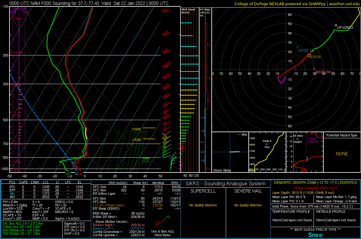 |
| 1/22 06z NAMNest 2 hour forecast cross section (valid at 08z/3 AM) of theta-e, temperature, frontogenesis, and omega. Note the area in the mid levels in NE NC where theta-e was briefly decreasing with height. This shows the presence of very weak elevated (upright) instability. | 1/22 06z NAMNest 2 hour forecast sounding (vaild at 08z/3 AM) from KECG (Elizabeth City Airport, NC) | 1/22 00z (7 PM on 1/21) NAM analysis sounding from KOFP (Ashland, VA). Note the very dry air in the lowest levels that prevented precipitation from initially reaching the ground. |
 |
Media use of NWS Web News Stories is encouraged! Please acknowledge the NWS as the source of any news information accessed from this site. |
|


 Coastal Flood
 Heat
Heat