Overview
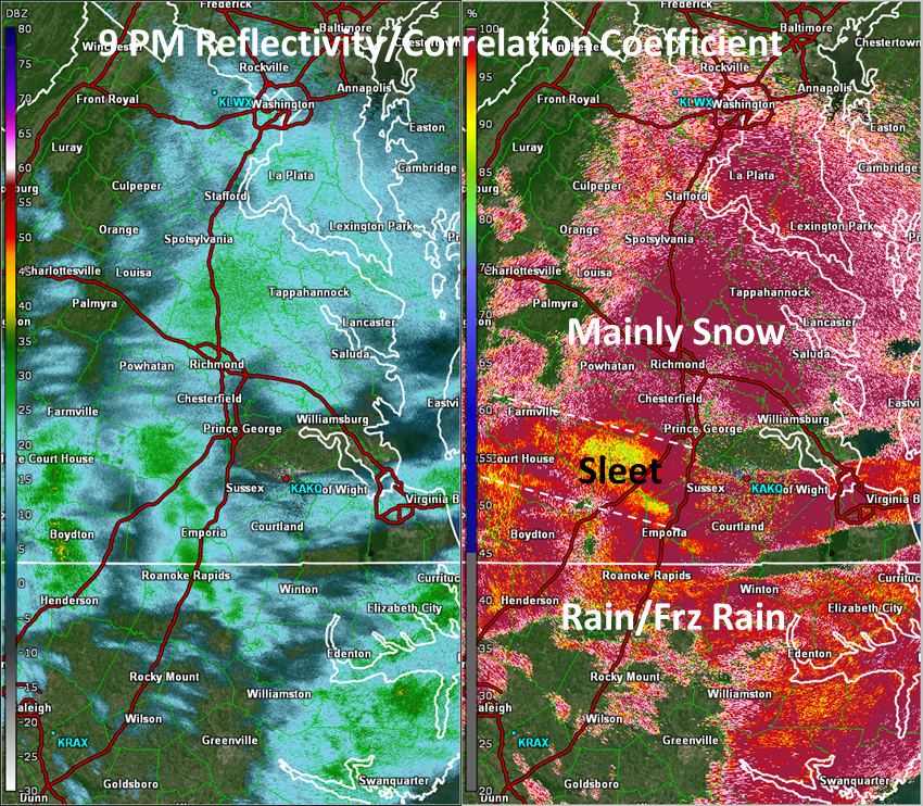
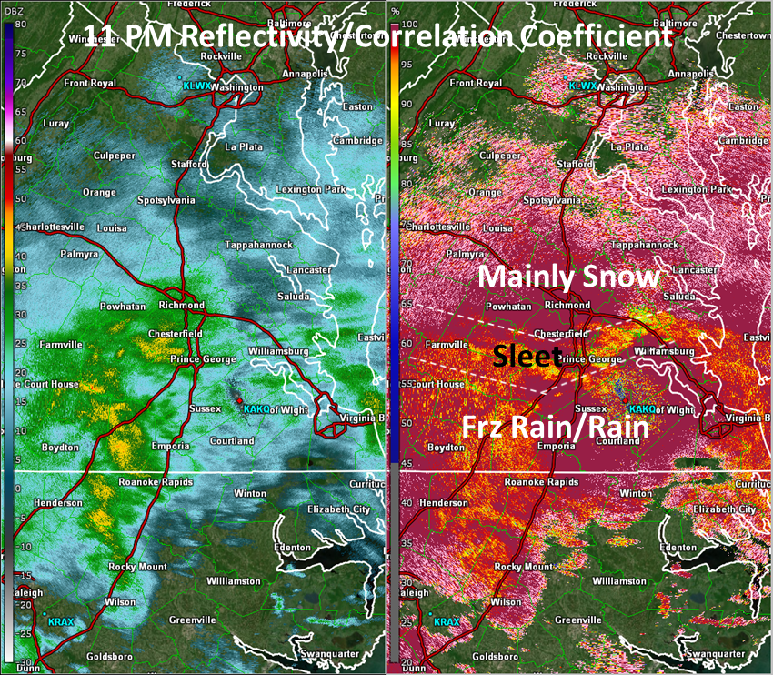
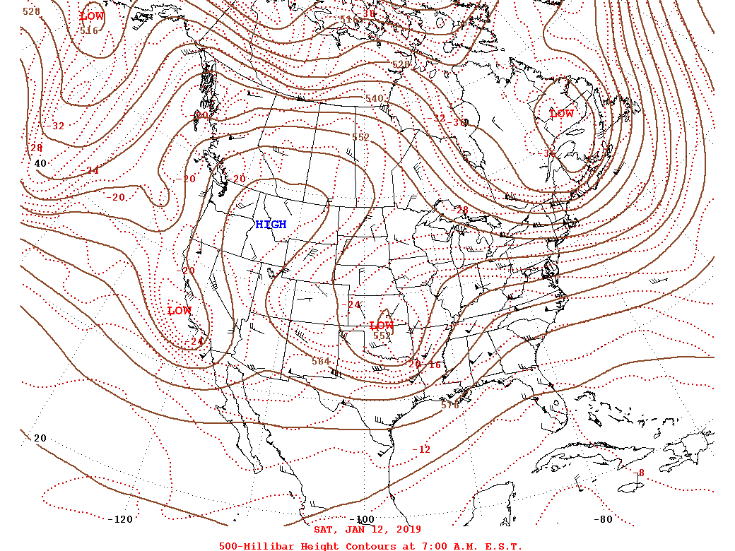
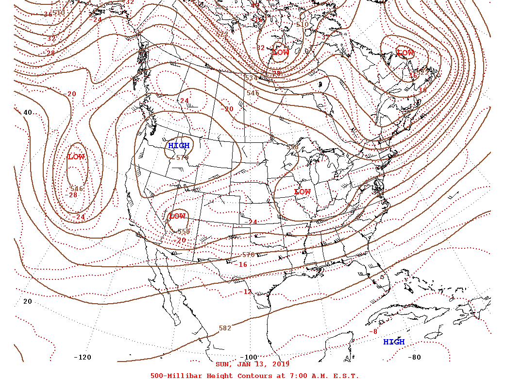
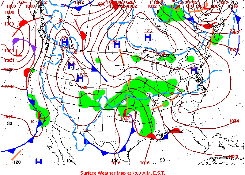
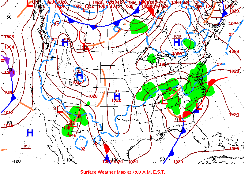
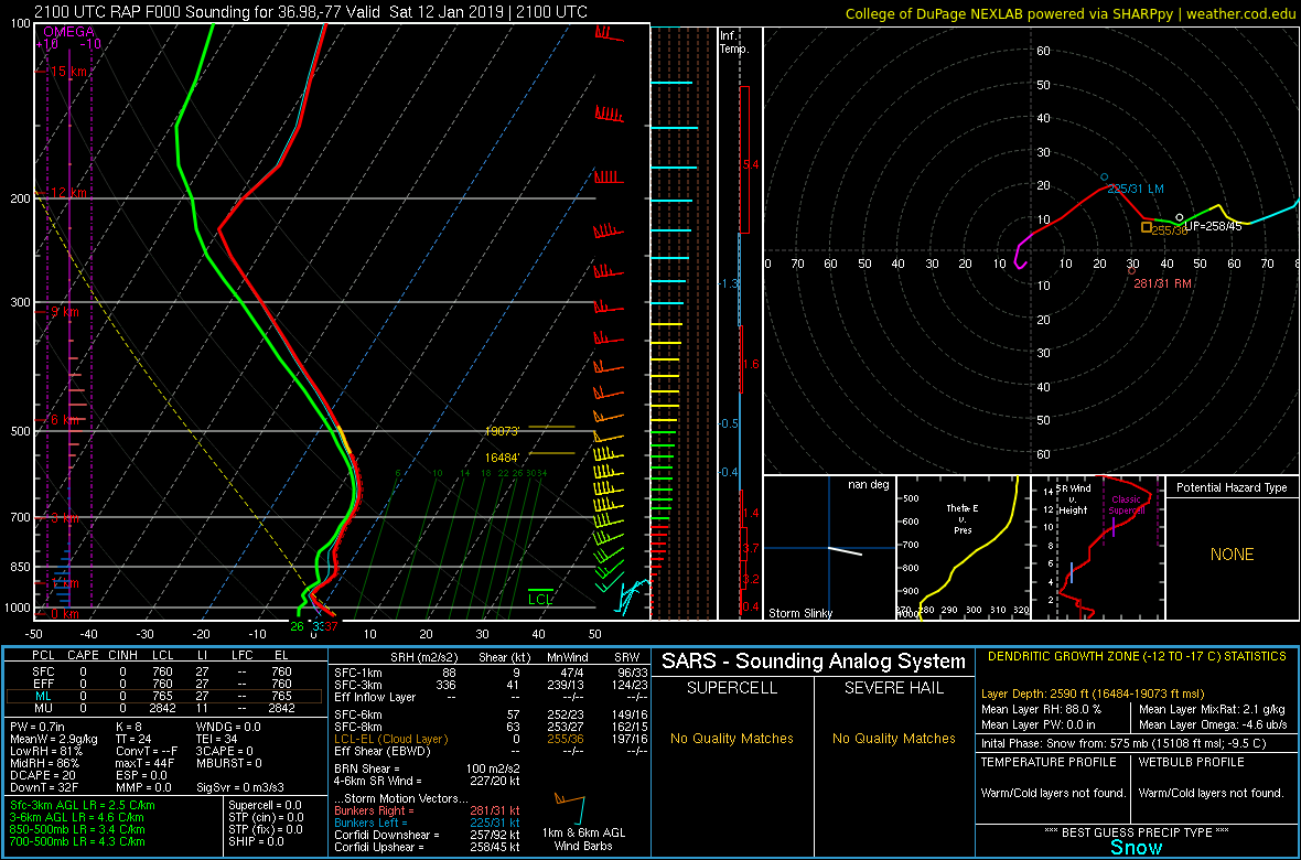
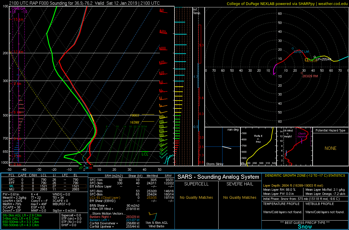
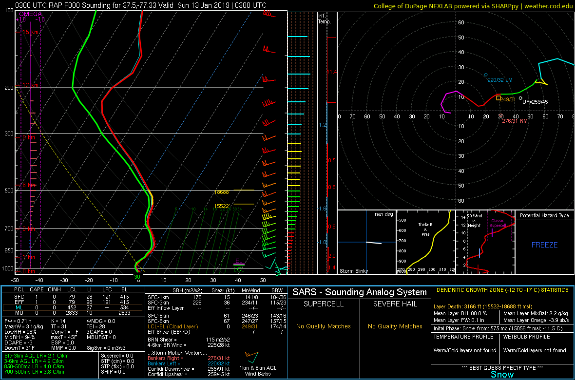
From January 11th to the morning of Saturday, January 12th, an upper level trough amplified over the Plains, as a strong upper high remained in place over the Northern Rockies and weak upper ridging was in place over the southeast US. In response, a well-defined area of surface low pressure became centered over eastern Oklahoma on the morning of January 12th. At the same time, synoptic analysis showed a ~1040 mb area of high pressure over Ontario, with the associated surface ridge extending southeastward into the Mid-Atlantic/Northeast. This allowed a cold-air damming regime to set up over the area on the 12th. As the low slowly moved to the ENE, broad scale WAA commenced as winds at the surface were out of the NE but veered to the SE then S from 925-700mb. This WAA produced large-scale ascent throughout the region, allowing areas of stratiform precipitation to form during the day on the 12th. As temperatures throughout the much of the lower atmosphere (except for very near the sfc) were at or below freezing over most of the area (except far SE VA/NE NC), precipitation was mainly in the form of snow. A quick inch or so of snow was observed from the central/southern Piedmont to the Richmond metro (and points just to the south) during the late afternoon through mid evening hours of the 12th. The first batch of significant precipitation moved into the region during the overnight hours on the 12th into the morning of the 13th as the upper low approached the area. While surface temperatures only warmed by a degree or two during the night, warm air aloft (most pronounced near the 850 mb level) moved northward through the night. This allowed precipitation to change over to rain east of I-95. However, temperatures stayed below 32° through the night from western Chesterfield county W to the Piedmont (leading to freezing rain throughout the night). Precipitation stayed in the form of snow from Louisa county to the Cambridge, MD area (where 3-5 inches of snow fell during the night of the 12th through the morning of the 13th).
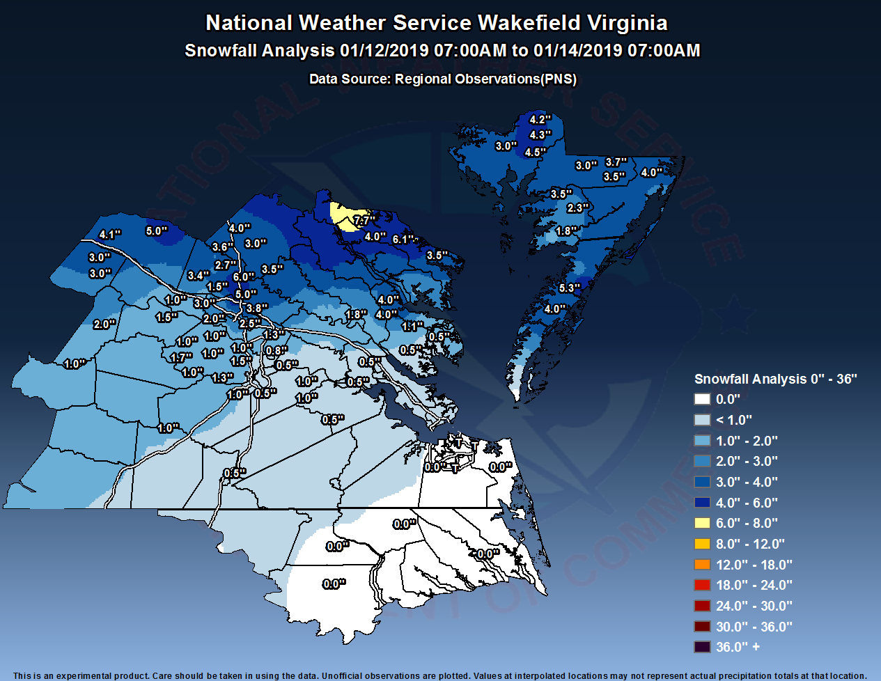
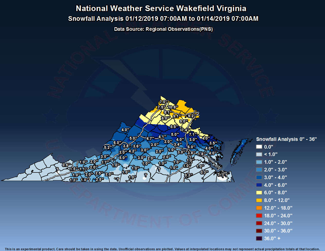
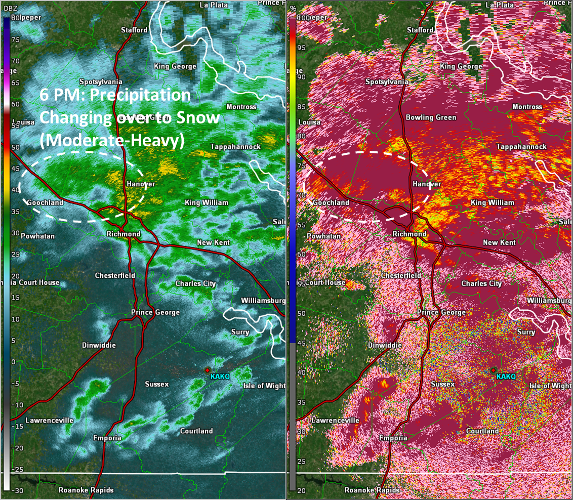
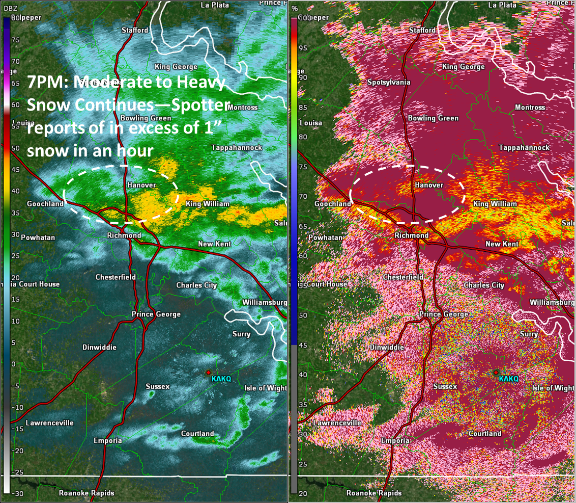
Precipitation changed to rain throughout the area by late morning on the 13th before changing back to snow during the early evening hours as the upper low moved just to the north of the region and a secondary surface low started to deepen offshore (allowing winds to shift to the N/NNW). Precipitation increased in intensity from the northern Richmond metro Lower Eastern Shore as the upper low moved nearly overhead. Localized banding was observed for a short time during the evening of the 13th. In a few spots, snowfall rates exceeded 1"/hour for a couple of hours during the evening of the 13th through the early morning of the 14th. As a result, roads quickly became slick and hazardous Sunday evening in spots. The low moved well offshore by sunrise on the 14th, allowing precipitation to come to an end. Storm totals were 2" or less south of I-64, with 2"-6" (locally up to 8") were observed. While not as large of an impact as the winter storm of 12/9/17, this was quite a significant winter storm across northern parts of the CWA (in addition to much of the Lower Eastern Shore).
Snowfall Totals - AKQ CWA and Statewide
Photos & Video
Header
| Caption (source) |
Caption (source) |
Caption (source) |
Caption (source) |
Selected Radar Images
Saturday Night-Early Sunday Morning
 |
 |
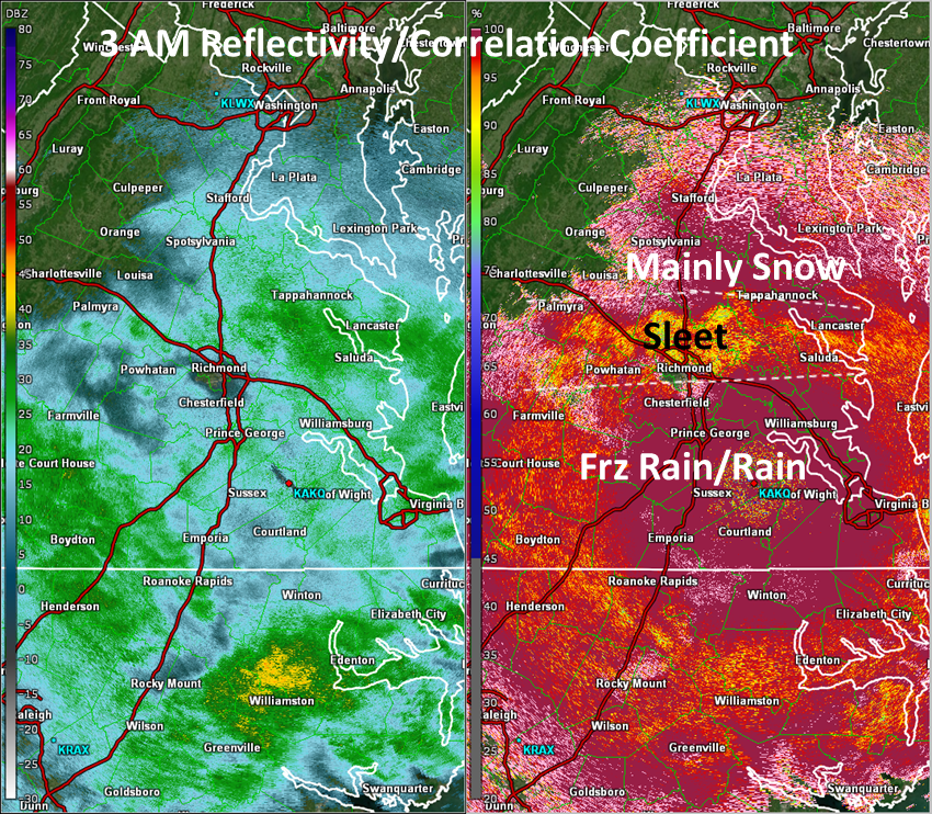 |
| Figure 1: 9 PM Saturday (1/12) 0.5° Base Reflectivity (left) and Correlation Coefficient (right) | Figure 2: 11 PM Saturday (1/12) 0.5° Base Reflectivity (left) and Correlation Coefficient (right) | Figure 1: 3 AM Sunday (1/13) 0.5° Base Reflectivity (left) and Correlation Coefficient (right) |
Sunday Night (Spotlight on brief heavy snow over northern Richmond Metro)
 |
 |
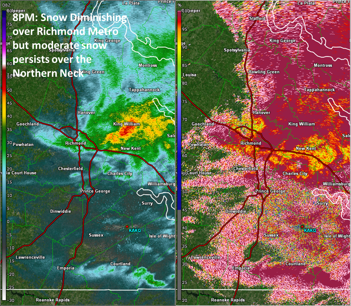 |
| Figure 1: 6 PM Sunday Evening 0.5° Base Reflectivity (left) and Correlation Coefficient (right) | Figure 1: 7 PM Sunday Evening 0.5° Base Reflectivity (left) and Correlation Coefficient (right) | Figure 1: 8 PM Sunday Evening 0.5° Base Reflectivity (left) and Correlation Coefficient (right) |
Storm Reports
Public Information Statement
National Weather Service Wakefield VA
1144 AM EST Mon Jan 14 2019

...STORM TOTAL SNOWFALL...

Location                     Amount    Time/Date       Provider

...Maryland...

...Dorchester County...
2 SE Linkwood                4.5 in    0900 AM 01/13   COCORAHS
2 ENE East New Market        4.3 in    0900 AM 01/14   Public
2 ENE East New Market        4.2 in    1154 AM 01/13   Public
1 W Cambridge                3.8 in    0900 AM 01/13   COCORAHS
1 SE Cambridge               3.0 in    0449 AM 01/13   911 Call Center

...Somerset County...
2 ENE Monie                  3.5 in    0700 AM 01/14   Cocorahs
2 SSW Princess Anne          2.3 in    0930 AM 01/13   COCORAHS
2 W Marion Station           1.8 in    0845 AM 01/13   Public

...Wicomico County...
Delmar                       4.0 in    1030 AM 01/13   COCORAHS
2 WNW Parsonsburg            3.7 in    0700 AM 01/14   Cocorahs
Salisbury-Wicomico           3.5 in    0609 AM 01/13
3 NW Shad Point              3.0 in    0502 AM 01/13

...Worcester County...
1 SSW Ocean Pines            4.0 in    0700 AM 01/14   Cocorahs
5 SE Ironshire               2.5 in    0700 AM 01/14   Cocorahs

...Virginia...

...Accomack County...
3 ESE Parksley               5.3 in    0700 AM 01/14   Public
1 SW Chincoteague            4.5 in    0700 AM 01/14   Cocorahs
3 ENE Harborton              4.0 in    0700 AM 01/14   Cocorahs
2 SW Clam                    3.0 in    0603 AM 01/14   Public
Wallops Island               3.0 in    1214 AM 01/14   CO-OP Observer
Bloxom                       2.5 in    0504 AM 01/14   Trained Spotter

...Brunswick County...
5 N Alberta                  1.0 in    0800 AM 01/13   COOP

...Caroline County...
3 NE Corbin                  4.5 in    0738 AM 01/13   Public
Ladysmith                    4.0 in    0700 AM 01/14   Cocorahs
2 SSE Dawn                   3.5 in    0700 AM 01/14   Cocorahs
3 NNW Burruss Corner         3.0 in    0700 AM 01/13   COCORAHS

...Chesterfield County...
Winterpock                   1.7 in    0245 AM 01/13   Public
3 SSW Chesterfield           1.5 in    0800 AM 01/13   COCORAHS
5 SSW Beach                  1.3 in    0700 AM 01/14   Cocorahs
2 ENE Midlothian             1.2 in    0130 AM 01/13   Public
3 ESE Moseley                1.0 in    0700 AM 01/14   Public
Bon Air                      1.0 in    0304 PM 01/13   Public
4 W Winterpock               1.0 in    0700 AM 01/13   COOP
Chesterfield                 1.0 in    1010 PM 01/12   Public
1 SSE Meadowville            0.8 in    0900 PM 01/12
1 SE Pocahontas State Park   0.5 in    1230 AM 01/13

...City of Emporia...
Emporia                      0.3 in    1015 PM 01/12   Public

...City of Hopewell...
Hopewell                     0.3 in    0400 PM 01/13   COOP

...City of Norfolk...
Ghent                         T in     0700 AM 01/13   COCORAHS
Norfolk                       T in     1159 PM 01/12   COOP

...City of Petersburg...
1 W Petersburg               1.0 in    0700 AM 01/13   Trained Spotter

...City of Portsmouth...
Cradock                       T in     0700 AM 01/13   COCORAHS

...City of Richmond...
2 N Downtown Richmond        2.5 in    0923 PM 01/13   Public
2 SSW Dumbarton              2.0 in    0700 AM 01/14   Public

...City of Williamsburg...
1 ENE Williamsburg           0.5 in    0700 AM 01/13   COCORAHS

...Cumberland County...
Cumberland                   2.0 in    0454 AM 01/13

...Fluvanna County...
Palmyra                      3.0 in    1031 AM 01/13   Public
Palmyra                      3.0 in    0115 AM 01/13   Public

...Gloucester County...
2 E Clay Bank                0.1 in    1053 PM 01/12

...Goochland County...
3 SE Rockville               1.5 in    1106 AM 01/13   Public
Crozier                      1.0 in    0700 AM 01/13   COOP

...Hanover County...
1 SW Ashland                 6.0 in    0800 PM 01/13   Public
Hewlett                      3.6 in    0700 AM 01/14   Cocorahs
3 NNW Gilman                 3.4 in    0700 AM 01/14   Cocorahs
Hewlett                      2.8 in    0700 AM 01/13   COCORAHS
3 NNW Gilman                 2.7 in    0855 AM 01/13   Public

...Henrico County...
Glen Allen                   5.0 in    0627 PM 01/13   Trained Spotter
1 NW Chamberlayne            3.8 in    0900 PM 01/13   Public
2 ENE Short Pump             3.0 in    0700 AM 01/14   Cocorahs
2 E Short Pump               1.9 in    0712 AM 01/13   COCORAHS
1 N Varina                   1.3 in    0700 AM 01/14   Cocorahs

...James City County...
2 N Five Forks               0.8 in    1000 PM 01/12   Public
2 SSW Ewell                  0.5 in    0800 AM 01/13   COCORAHS
Williamsburg 3.2 W           0.5 in    0700 AM 01/13   COCORAHS

...King William County...
West Point                   1.8 in    0700 AM 01/14   Public

...Lancaster County...
1 SSE Mollusk                3.5 in    0700 AM 01/14   Cocorahs
1 ESE Mollusk                0.7 in    0700 AM 01/13   COCORAHS

...Louisa County...
3 ESE Wares Crossroads       5.0 in    1017 AM 01/13   Public
1 NNE Zion Crossroads        4.1 in    0700 AM 01/14   Cocorahs

...Mathews County...
North                        0.5 in    0700 AM 01/13   COOP

...Middlesex County...
1 E Remlik                   4.0 in    0700 AM 01/14   Public
1 SW Urbanna                 4.0 in    0700 AM 01/14   Public
1 W Stampers                 1.1 in    0700 AM 01/14   Cocorahs

...Northumberland County...
2 NNE Lottsburg              6.1 in    0700 AM 01/14   Cocorahs
2 E Howland                  3.5 in    0700 AM 01/14   Cocorahs

...Powhatan County...
Powhatan                     1.5 in    0550 AM 01/13   Public

...Prince Edward County...
Farmville                    1.0 in    0700 AM 01/13   COCORAHS

...Prince George County...
3 S Garysville               1.0 in    0700 AM 01/13   COCORAHS
4 NNW Barham                 1.0 in    0800 PM 01/12   NWS Employee
1 N Prince George Golf       0.3 in    1200 AM 01/13   NWS Employee

...Surry County...
Claremont                     T in     0803 AM 01/13   COCORAHS

...Sussex County...
Nws Offfice                  0.3 in    1200 AM 01/13   COOP

...Westmoreland County...
Stratford Hall               7.7 in    0700 AM 01/14   Cocorahs
Oldhams                      4.0 in    0341 AM 01/13   Public

&&
Environment
Upper Level synoptic summary.
 |
 |
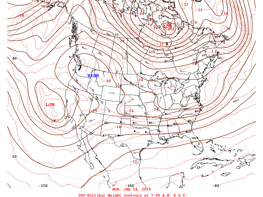 |
| Figure 1: 12z/1-12 500hPa Heights | Figure 2: 12z/1-13 500hPa Heights | Figure 3: 12z/1-14 500hPa Heights |
Surface synoptic summary.
 |
 |
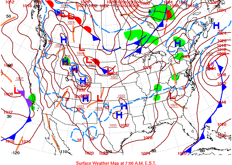 |
| Figure 4: 12z/1-12 Surface Map | Figure 5: 12z/1-13 Surface Map | Figure 6: 12z/1-14 Surface Map |
Selected Soundings from Saturday Afternoon-Early Sunday Morning.
 |
 |
 |
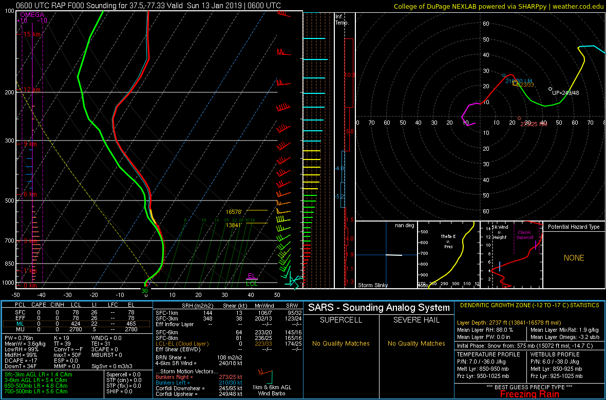 |
| Figure 7: 21z/1-12 KRIC Sounding | Figure 8: 21z/1-12 KPHF Sounding | Figure 9: 03z/1-13 KRIC Sounding | Figure 10: 06z/1-13 KRIC Sounding |
 |
Media use of NWS Web News Stories is encouraged! Please acknowledge the NWS as the source of any news information accessed from this site. |
 |