Overview
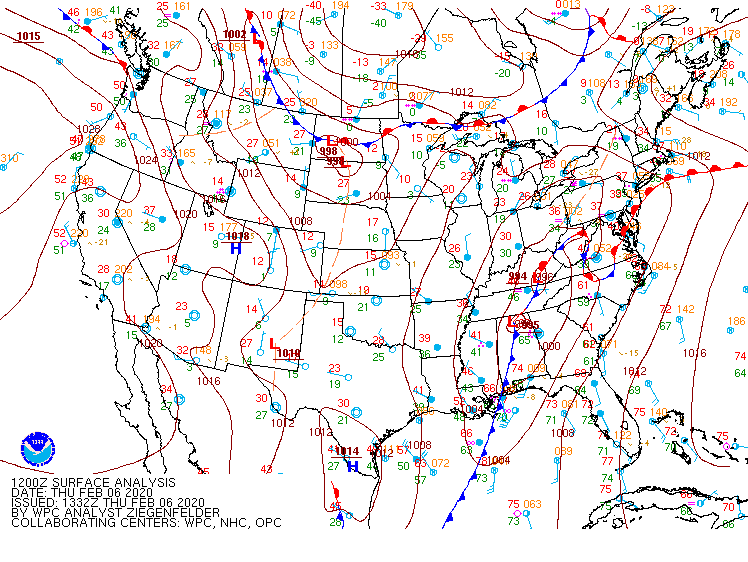
On the morning of February 6th, an upper shortwave was lifting northeast from the southern Plains to the Lower Mississippi Valley. Our region was under SW flow aloft as several upper disturbances tracked across the region. At the surface, a broad area of ~996 mb low pressure was centered from eastern KY to northern AL, with a the associated (trailing) cold front extending southward into the Gulf of America. A nearly stationary SW-NE oriented frontal boundary was draped from the northern NC Piedmont the Lower Eastern Shore. Temperatures were in the low-mid 60s across NE NC (in the warm sector), with upper 30s-mid 40s across the northwest two-thirds of the CWA. Strong southwesterly flow from 925-500 mb was advecting anomalous amounts of Gulf moisture into the region, and PWs were near record values throughout the CWA (especially SE).
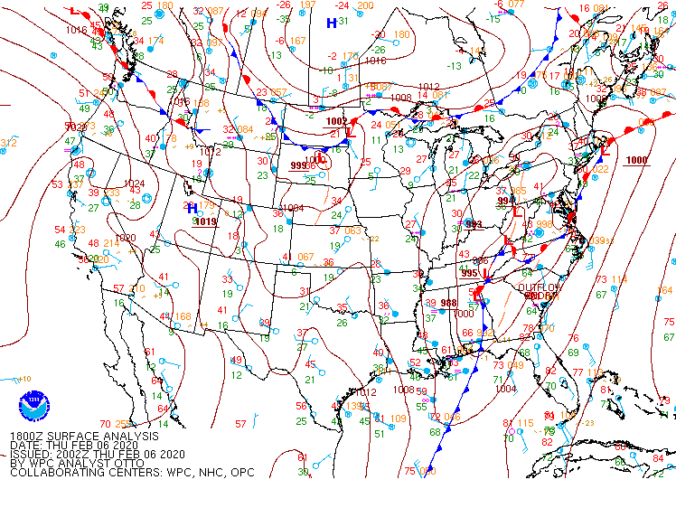
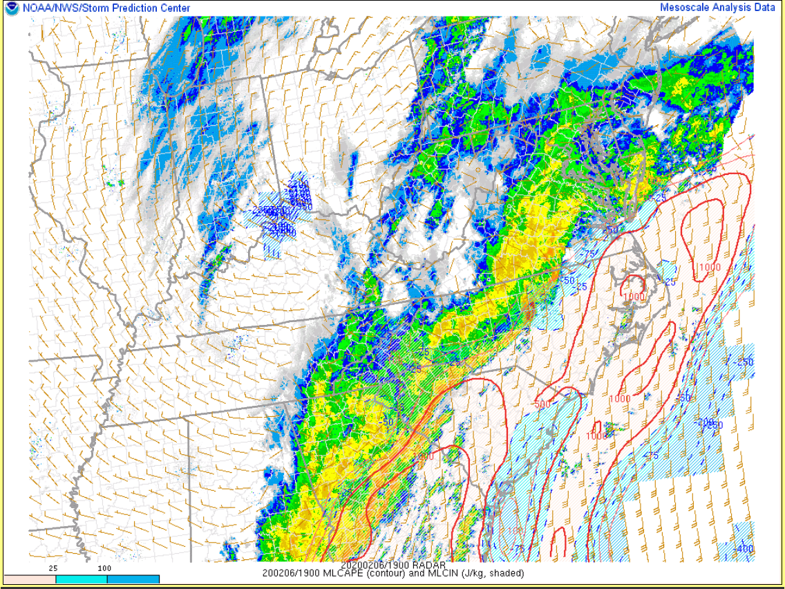
Moderate (to occasionally heavy) rain was ongoing across the area as the frontal boundary struggled to lift northward, with a line of showers and thunderstorms just ahead of the trailing cold front (well to our southwest). Moderate to heavy rain continued across the NW two-thirds of the CWA through much of the day (as the aforementioned frontal boundary struggled to move NW of a Henderson (NC)-Emporia-Wakefield-Salisbury (MD) line). Temperatures did not get out of the 40s NW of the boundary. However, partial clearing occurred over far SE VA/NE NC, allowing temperatures to warm into the low 70s by early afternoon (with dew points in the mid-upper 60s). This happened at the same time as the aforementioned line of thunderstorms outpaced the trailing cold front, moving into the central Carolinas by early afternoon. The environment in the warm sector was characterized by a 60-75 knot southwesterly low-level jet from 925-850 mb, with 15-25 knot SSW winds at the surface. While low-level lapse rates were relatively modest, temperatures in the 70s/dew points in the mid-upper 60s were enough for mixed-layer CAPE of 500-1000 J/kg across NE NC Thursday afternoon. In addition, a meso-low had developed along the boundary (near AKQ) by 2-3 PM, with some (subtle) localized backing of the surface wind field just SE of the meso-low. This allowed effective SRH values to climb to 400-600 m2/s2 over parts of NC by mid afternoon. The line quickly moved across the area during the mid-late afternoon (w/ some elevated convection noted across central/eastern VA just north of the frontal boundary). This caused widespread 45-65 mph wind gusts across SE VA/NE NC, with one brief EF-0 tornado across Gates County, NC.
While rain continued across the area overnight (producing some minor flooding), no additional severe weather was observed through 7 AM Friday (2/7). However, the parent surface low rapidly deepened overnight as it moved northeast. By 7 AM Friday (2/7), the minimum central pressure of the low was ~980 mb and it was centered just near the Mason-Dixon Line. Southerly winds increased overnight, and temperatures/dew points were in the upper 50s-near 60° across much of Virginia/Maryland. A broken line of showers (ahead of the trailing cold front) was just to the west of the CWA by 7 AM Monday. This line of showers quickly crossed the area Friday morning before exiting to our north/east by midday. Despite temperatures/dew points only in the upper 50s, strong kinematic fields in the low and mid levels allowed these showers to produce wind gusts of 50-70 mph (mainly along and east of I-95). There were several reports of wind damage/trees down. At one point, 100,000 people were without power across our CWA Friday morning.
Tornadoes:
|
Tornado - Just East of Eure
Track Map 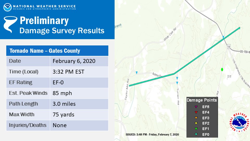 
Downloadable KMZ File |
||||||||||||||||
The Enhanced Fujita (EF) Scale classifies tornadoes into the following categories:
| EF0 Weak 65-85 mph |
EF1 Moderate 86-110 mph |
EF2 Significant 111-135 mph |
EF3 Severe 136-165 mph |
EF4 Extreme 166-200 mph |
EF5 Catastrophic 200+ mph |
 |
|||||
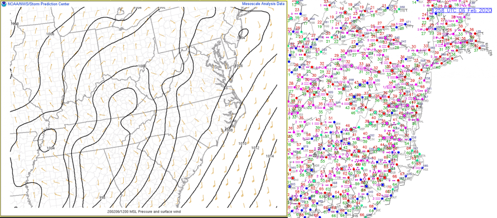
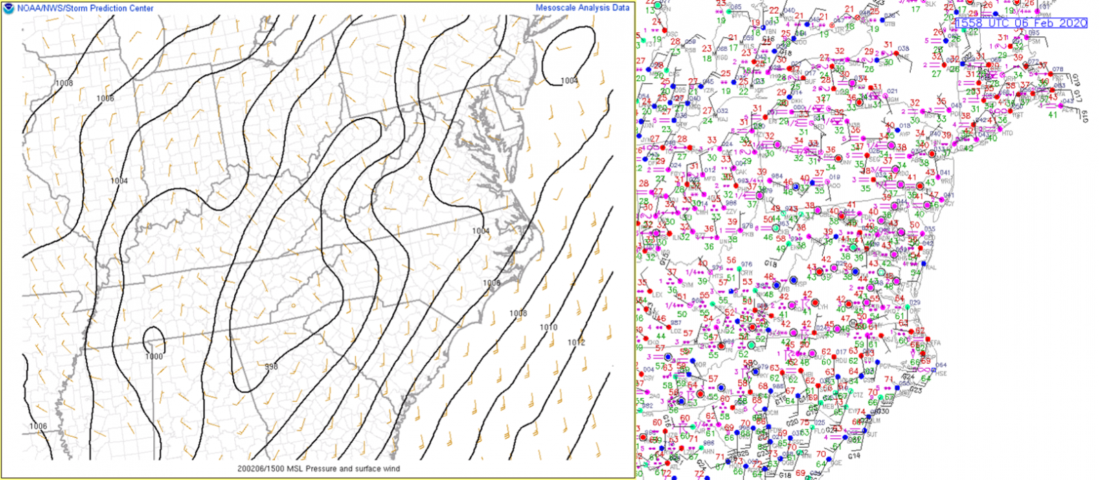
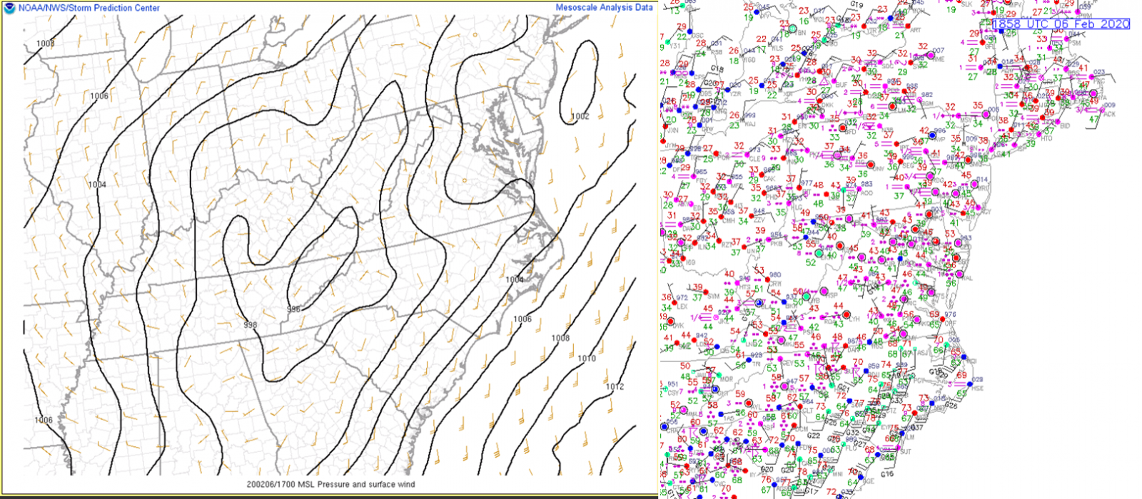
Mesoscale Surface Analysis/Obs:
 |
 |
| 12z/7 AM Mesoscale Surface Analysis/Observations | 15z/10 AM Mesoscale Surface Analysis/Observations |
 |
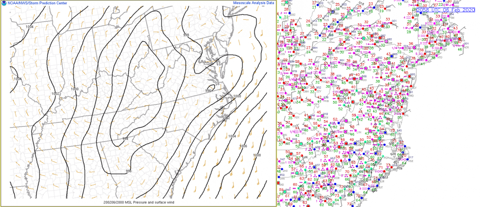 |
| 18z/1 PM Mesoscale Surface Analysis/Observations | 20z/3 PM Mesoscale Surface Analysis/Observations |
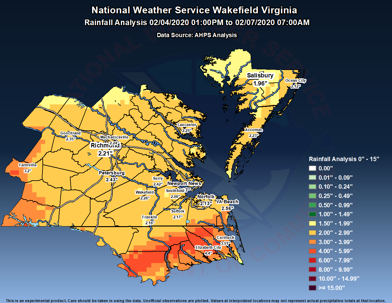
Rainfall/Storm Report Maps
 |
 |
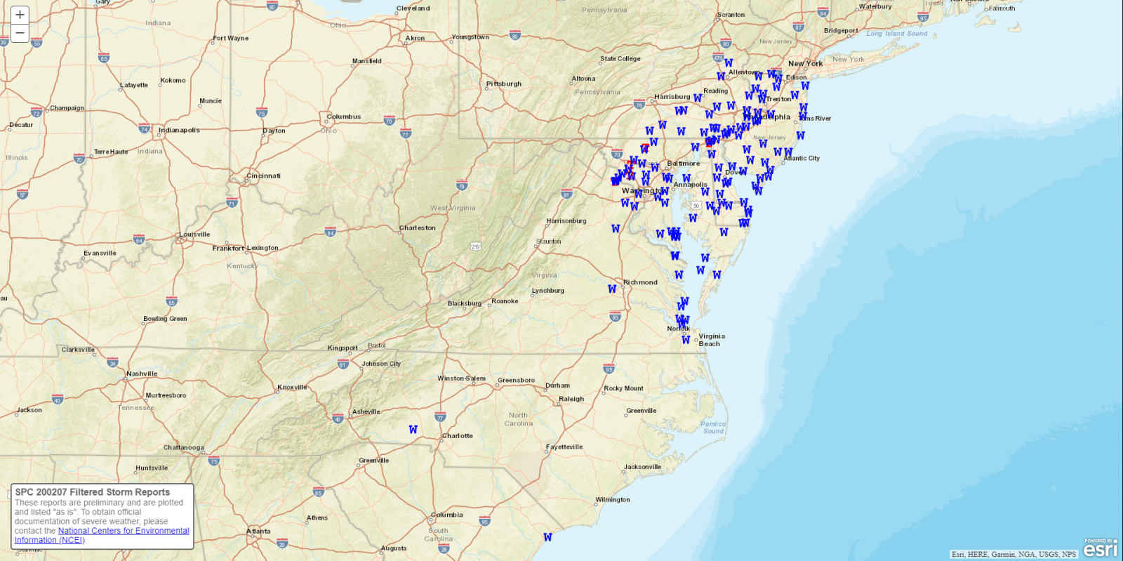 |
| Storm Total Rainfall Map | 2-6 Regional SPC Storm Reports | 2-7 Regional SPC Storm Reports |
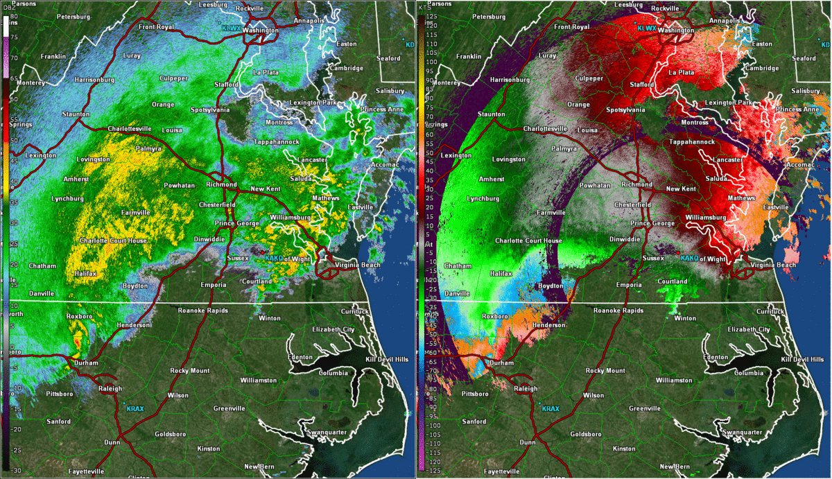
Selected Radar Images
 |
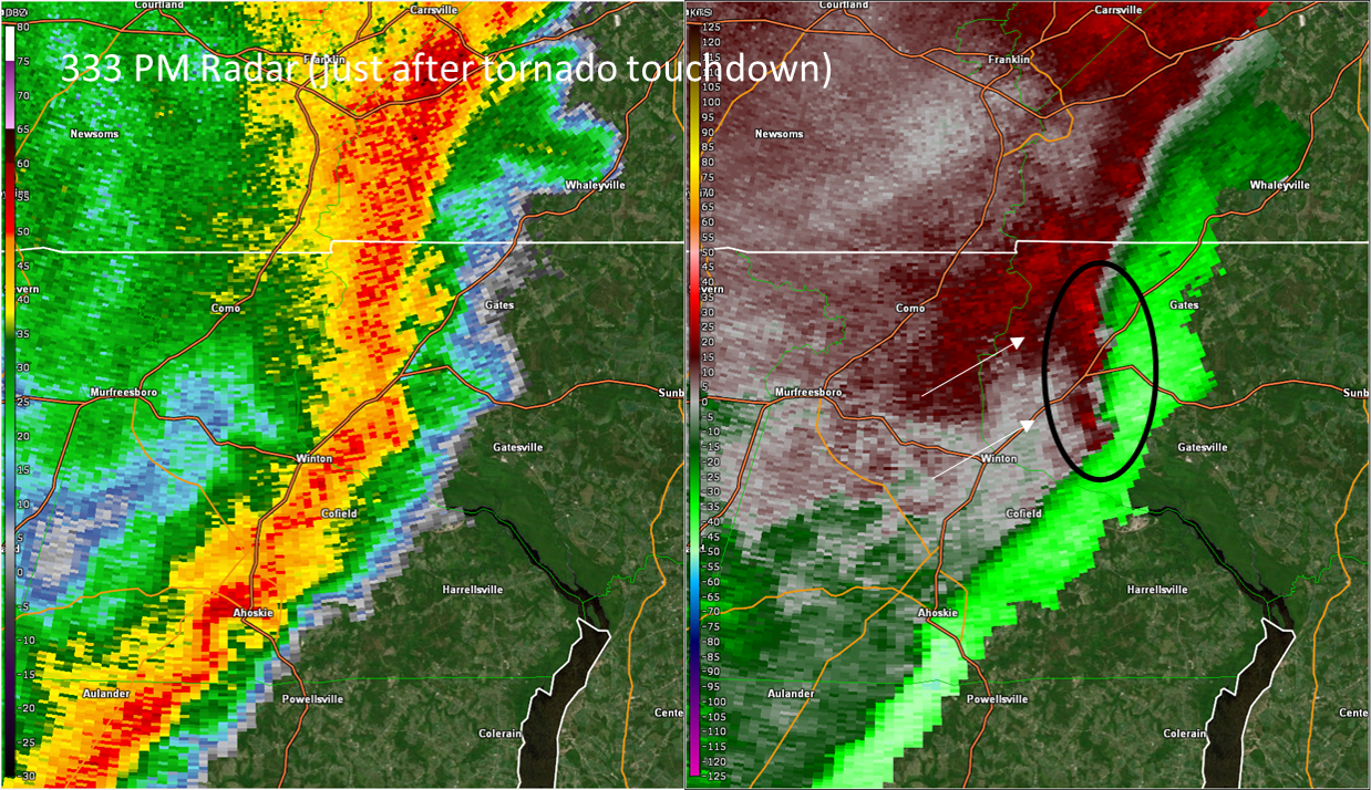 |
| Radar Loop from 130 PM to 530 PM in 30 minute increments | 0.5° Reflectivity (left) and 0.5° Velocity (right) at the time of the tornado touchdown in Gates County. Note the mesovorticies with broad rotation on the leading edge of the line. Several of these were observed during the afternoon of 2/6...but only one ended up producing a tornado. |
Rainfall Reports
Public Information Statement National Weather Service Wakefield VA 1153 AM EST Fri Feb 7 2020 ...PRECIPITATION REPORTS... Location Amount Time/Date Provider ...Maryland... ...Dorchester County... Blackwater 1.81 in 1126 AM 02/07 RAWS East New Market 0.0 WNW 1.55 in 0700 AM 02/07 COCORAHS Cambridge 1.43 in 1131 AM 02/07 CWOP Toddville 1.37 in 1144 AM 02/07 CWOP Cambridge 1.31 in 1141 AM 02/07 CWOP NEAVITT 1.31 in 1131 AM 02/07 CWOP ...Somerset County... Crisfield 3.6 NE 2.41 in 0700 AM 02/07 COCORAHS Deal Island 0.5 SSW 2.39 in 0700 AM 02/07 COCORAHS 1.0 NE Princess Anne 2.33 in 0800 AM 02/07 COOP Princess Anne 1.45 in 1141 AM 02/07 CWOP Crisfield 0.95 in 1145 AM 02/07 AWS ...Wicomico County... Fruitland 1.8 ENE 2.40 in 0700 AM 02/07 COCORAHS Parsonsburg 1.6 WNW 2.27 in 0700 AM 02/07 COCORAHS Delmar 0.2 NE 2.15 in 0659 AM 02/07 COCORAHS Salisbury 2.11 in 1143 AM 02/07 CWOP Salisbury Wicomico Airport 1.15 in 1054 AM 02/07 ASOS Powellville 0.65 in 1048 AM 02/07 RAWS ...Worcester County... Ocean Pines 1.5 SE 2.51 in 0730 AM 02/07 COCORAHS Snow Hill 0.4 S 2.43 in 0700 AM 02/07 COCORAHS Berlin 6.5 SSE 2.34 in 0800 AM 02/07 COCORAHS Ocean City 4.6 NNW 2.28 in 0700 AM 02/07 COCORAHS Assateague Island 2.23 in 1040 AM 02/07 RAWS Bishopville 3.1 E 2.21 in 0500 AM 02/07 COCORAHS Ocean City 2.13 in 1053 AM 02/07 ASOS 1 SSW Ocean City 1.83 in 1145 AM 02/07 AWS ...North Carolina... ...Bertie County... Merry Hill 3.2 N 3.40 in 0700 AM 02/07 COCORAHS 3.1 E Windsor 3.33 in 0817 AM 02/07 HADS Greens Cross 3.33 in 1117 AM 02/07 RAWS ...Camden County... South Mills 4.33 in 0915 AM 02/07 HADS Shiloh 2.30 in 1132 AM 02/07 CWOP South Mills 0.40 in 1143 AM 02/07 CWOP ...Chowan County... Colerain 5.7 ENE 4.38 in 0800 AM 02/07 COCORAHS Edenton 13.3 NNW 4.16 in 0800 AM 02/07 COCORAHS Edenton 9.7 NNW 3.80 in 0700 AM 02/07 COCORAHS Edenton 3.02 in 1135 AM 02/07 AWOS ...Currituck County... Grandy 0.6 E 4.08 in 0700 AM 02/07 COCORAHS Corolla 3.19 in 1145 AM 02/07 CWOP Currituck 2.97 in 1015 AM 02/07 AWOS Point Harbor 0.2 WSW 1.80 in 0700 AM 02/07 COCORAHS ...Hertford County... Ahoskie Tri Coun 2.94 in 1135 AM 02/07 AWOS Murfreesboro 1 NE 2.49 in 0600 AM 02/07 COOP ...Northampton County... Henrico 0.4 S 2.52 in 0800 AM 02/07 COCORAHS Henrico 2.38 in 1130 AM 02/07 CWOP Conway 1.99 in 1140 AM 02/07 CWOP ...Pasquotank County... Elizabeth City 1.8 SE 4.64 in 0800 AM 02/07 COCORAHS Elizabeth City 4.55 in 1100 AM 02/07 HADS Elizabeth City 2.6 W 4.44 in 0800 AM 02/07 COCORAHS Elizabeth City Airport 4.05 in 1054 AM 02/07 ASOS ...Perquimans County... Hertford 4.66 in 1145 AM 02/07 CWOP Hertford 4.37 in 1143 AM 02/07 CWOP Hertford 7.7 SSE 4.26 in 0700 AM 02/07 COCORAHS Hertford 5.2 SSE 4.08 in 0700 AM 02/07 COCORAHS Hertford 11.4 E 3.88 in 0700 AM 02/07 COCORAHS Hertford 3.10 in 1140 AM 02/07 CWOP ...Virginia... ...Accomack County... Onley 0.6 SE 2.61 in 0800 AM 02/07 COCORAHS Painter 4.4 W 2.48 in 0600 AM 02/07 COCORAHS Metompkin 0.9 SE 2.45 in 0700 AM 02/07 COCORAHS Wallops Island 2.40 in 1054 AM 02/07 ASOS Parksley 1.80 in 1130 AM 02/07 CWOP Wallops Island 2.0 NW 1.40 in 0700 AM 02/07 COCORAHS Melfa Accomack 1.22 in 1055 AM 02/07 AWOS ...Amelia County... Jetersville 3.6 W 2.70 in 0800 AM 02/07 COCORAHS Ford 2.02 in 1132 AM 02/07 CWOP Amelia Courthouse 1.79 in 1145 AM 02/07 AWS ...Brunswick County... South Hill Meckl 1.87 in 1135 AM 02/07 AWOS Lawrenceville 1.20 in 0755 AM 02/07 AWOS ...Caroline County... Hanover 3.0 N 1.96 in 0700 AM 02/07 COCORAHS Faph_south 1 1.93 in 1133 AM 02/07 RAWS Bowling Green 1.76 in 1144 AM 02/07 AWS A.P. Hill_delos 1.66 in 1133 AM 02/07 RAWS A.P. Hill_eodtc 1.62 in 1132 AM 02/07 RAWS A.P. Hill_north1 1.42 in 1126 AM 02/07 RAWS Ladysmith 0.90 in 1145 AM 02/07 AWS ...Chesterfield County... Chesterfield 2.88 in 1140 AM 02/07 CWOP Midlothian 2.50 in 0945 AM 02/07 CWOP Midlothian 4.7 SSW 2.42 in 0700 AM 02/07 COCORAHS Matoaca 2.34 in 1140 AM 02/07 CWOP Richmond 7.5 SW 2.33 in 0700 AM 02/07 COCORAHS Winterpock 2.32 in 1135 AM 02/07 CWOP 2 NE Chester 2.30 in 1144 AM 02/07 AWS Midlothian 5.4 S 2.20 in 0700 AM 02/07 COCORAHS Midlothian 3.5 SSW 2.17 in 0800 AM 02/07 COCORAHS Richmond Chester 2.11 in 1056 AM 02/07 AWOS Midlothian 1.97 in 1142 AM 02/07 CWOP Winterpock 1.96 in 1145 AM 02/07 CWOP Midlothian 1.95 in 1130 AM 02/07 CWOP Moseley 1.93 in 1131 AM 02/07 CWOP Midlothian 1.86 in 1145 AM 02/07 CWOP 5 NNE Winterpock 1.83 in 0948 AM 02/07 AWS Bon Air 1.76 in 1144 AM 02/07 AWS 4 S Midlothian 1.60 in 1144 AM 02/07 AWS Bon Air 1.57 in 1131 AM 02/07 CWOP 4 NW Beach 1.53 in 1145 AM 02/07 AWS Chesterfield 1.51 in 1115 AM 02/07 CWOP Midlothian 0.99 in 1145 AM 02/07 CWOP ...City of Chesapeake County... 7.4 NW Horseshoe 3.45 in 1100 AM 02/07 HADS Chesapeake 3.5 NE 3.07 in 0600 AM 02/07 COCORAHS 8.0 SW Chesapeake Airport 3.05 in 0930 AM 02/07 HADS Chesapeake 7.3 NE 2.87 in 0800 AM 02/07 COCORAHS Chesapeake 2.84 in 1145 AM 02/07 CWOP Chesapeake 3.8 NNW 2.82 in 0800 AM 02/07 COCORAHS Deep Creek 2.75 in 0930 AM 02/07 HADS Chesapeake 2.70 in 1139 AM 02/07 CWOP Chesapeake 2.66 in 1116 AM 02/07 CWOP Chesapeake 2.43 in 1141 AM 02/07 CWOP Fentress Naval 2.29 in 0856 AM 02/07 AWOS Norfolk 2.14 in 1005 AM 02/07 CWOP Greenbrier 2.06 in 1145 AM 02/07 AWS Chesapeake 1.26 in 1131 AM 02/07 CWOP ...City of Emporia County... Emporia Reservoir 2.42 in 0700 AM 02/07 COOP ...City of Franklin County... Franklin 0.5 ESE 2.07 in 0700 AM 02/07 COCORAHS 1 SE Franklin 1.59 in 1144 AM 02/07 AWS 1.0 E Franklin 0.88 in 1100 AM 02/07 HADS ...City of Hampton County... Hampton 8.1 W 2.08 in 0600 AM 02/07 COCORAHS Langley AFB Hamp 1.69 in 1127 AM 02/07 AWOS Hampton 1.29 in 1142 AM 02/07 CWOP ...City of Hopewell County... 1 NE Hopewell 1.90 in 1145 AM 02/07 AWS ...City of Newport News County... Newport News 2.5 ESE 2.08 in 0700 AM 02/07 COCORAHS Newport News 3.3 E 2.03 in 0500 AM 02/07 COCORAHS Newport News 1.99 in 1054 AM 02/07 ASOS Newport News 1.94 in 0935 AM 02/07 CWOP ...City of Norfolk County... Norfolk 2.23 in 1131 AM 02/07 CWOP Norfolk 2.21 in 1141 AM 02/07 CWOP Norfolk NAS Cham 2.19 in 1059 AM 02/07 AWOS Norfolk Intl Airport 2.18 in 1051 AM 02/07 ASOS Norfolk 5.0 SSW 2.17 in 0700 AM 02/07 COCORAHS Norfolk 2.11 in 1100 AM 02/07 CWOP Tampa 1.91 in 1144 AM 02/07 CWOP Norfolk 1.6 NNW 1.91 in 0700 AM 02/07 COCORAHS Ghent 1.75 in 1144 AM 02/07 AWS 1.6 SE Norview 1.58 in 1159 PM 02/06 COOP ...City of Poquoson County... Poquoson 5.8 W 2.17 in 0700 AM 02/07 COCORAHS Poquoson 1.25 in 1133 AM 02/07 CWOP ...City of Portsmouth County... Portsmouth 4.1 SSE 2.64 in 0700 AM 02/07 COCORAHS Portsmouth 2.61 in 1143 AM 02/07 CWOP ...City of Richmond County... Richmond 1.1 SE 2.17 in 0728 AM 02/07 COCORAHS Richmond 3.9 NW 2.09 in 0700 AM 02/07 COCORAHS Richmond 1.60 in 1142 AM 02/07 CWOP 2 SW Roslyn Hills 1.40 in 1145 AM 02/07 AWS 2 SW Dumbarton 1.29 in 1145 AM 02/07 AWS ...City of Suffolk County... Gdr 2.79 in 1126 AM 02/07 RAWS 2.2 SE Saunders 2.56 in 0726 AM 02/07 HADS Suffolk 4.9 NE 2.03 in 0700 AM 02/07 COCORAHS Suffolk 3.1 NNW 2.01 in 0612 AM 02/07 COCORAHS Suffolk 2.9 NNW 1.95 in 0700 AM 02/07 COCORAHS Suffolk 1.80 in 1135 AM 02/07 AWOS Suffolk 1.68 in 1131 AM 02/07 CWOP Suffolk 1.56 in 1131 AM 02/07 CWOP ...City of Virginia Beach County... Virginia Beach 3.1 ENE 4.07 in 0700 AM 02/07 COCORAHS Creeds 4.03 in 1106 AM 02/07 CWOP Virginia Beach 3.77 in 1145 AM 02/07 CWOP Virginia Beach 2.4 N 3.47 in 0700 AM 02/07 COCORAHS 4.4 S Sandbridge Beach 3.32 in 0727 AM 02/07 HADS Virginia Beach 3.31 in 1144 AM 02/07 CWOP Back Bay 3.22 in 1127 AM 02/07 RAWS Virginia Beach 3.16 in 1145 AM 02/07 CWOP McHenry 3.13 in 1137 AM 02/07 CWOP Virginia Beach 3.1 ENE 3.07 in 0700 AM 02/07 COCORAHS Virginia Beach 3.05 in 1140 AM 02/07 CWOP Virginia Beach 3.04 in 1140 AM 02/07 CWOP North Port 2.80 in 1140 AM 02/07 CWOP Virginia Beach 6.7 NW 2.70 in 0830 AM 02/07 COCORAHS Virginia Beach 11.2 NNW 2.45 in 0700 AM 02/07 COCORAHS Virginia Beach 2.43 in 1131 AM 02/07 CWOP Oceana NAS Souce 2.43 in 1056 AM 02/07 AWOS Virginia Beach 2.35 in 1145 AM 02/07 CWOP Virginia Beach 2.12 in 1142 AM 02/07 CWOP Virginia Beach 2.08 in 1145 AM 02/07 CWOP ...City of Williamsburg County... Williamsburg 1.3 SSW 2.58 in 0700 AM 02/07 COCORAHS Williamsburg 1.4 ENE 2.43 in 0700 AM 02/07 COCORAHS Williamsburg 1.62 in 1145 AM 02/07 AWS ...Cumberland County... 1.2 E Reeds 2.70 in 0700 AM 02/07 COOP Farmville 2.47 in 1135 AM 02/07 AWOS Farmville 2.43 in 1141 AM 02/07 CWOP ...Dinwiddie County... Dinwiddie 3.13 in 1140 AM 02/07 CWOP Churchroad 2.61 in 1131 AM 02/07 CWOP Petersburg 2.18 in 1135 AM 02/07 AWOS 1 ESE Addison 2.09 in 1145 AM 02/07 AWS ...Essex County... Tappahannock 1.48 in 1135 AM 02/07 AWOS Dunnsville 0.51 in 1143 AM 02/07 CWOP ...Fluvanna County... Scottsville 1.65 in 1140 AM 02/07 CWOP 1 S Union Mills 1.06 in 1144 AM 02/07 AWS ...Gloucester County... Zanoni 1.7 SSE 2.38 in 0800 AM 02/07 COCORAHS Gloucester Point 2.4 E 2.34 in 0700 AM 02/07 COCORAHS Gloucester Courthouse 3.3 SE 2.32 in 0700 AM 02/07 COCORAHS Gloucester Courthouse 6.6 W 2.27 in 0800 AM 02/07 COCORAHS Gloucester Courthouse 3.3 SS 2.25 in 0800 AM 02/07 COCORAHS Gloucester Courthouse 5.8 SS 2.24 in 0800 AM 02/07 COCORAHS Hayes 1.78 in 1145 AM 02/07 CWOP ...Goochland County... Crozier 2.62 in 0700 AM 02/07 COOP Kents Store 1.99 in 1132 AM 02/07 CWOP Maidens 1.70 in 1130 AM 02/07 CWOP 1 N Fife 1.31 in 1145 AM 02/07 AWS ...Greensville County... Emporia 11.0 SW 2.75 in 0700 AM 02/07 COCORAHS Purdy 1.97 in 1014 AM 02/07 CWOP Emporia 1.64 in 1135 AM 02/07 AWOS ...Hanover County... Montpelier 2.13 in 1130 AM 02/07 CWOP Richmond Hanover 1.93 in 0754 AM 02/07 ASOS Montpelier 4.8 E 1.88 in 0715 AM 02/07 COCORAHS Beaverdam 4.3 ESE 1.79 in 0700 AM 02/07 COCORAHS Ashland 1.71 in 1130 AM 02/07 CWOP Beaverdam 1.70 in 1016 AM 02/07 CWOP Ashland 1.42 in 1145 AM 02/07 AWS Mechanicsville 1.42 in 1142 AM 02/07 CWOP Atlee 1.32 in 1145 AM 02/07 AWS ...Henrico County... Highland Springs 8.1 SE 2.56 in 0830 AM 02/07 COCORAHS Montrose 4.7 SSE 2.25 in 0700 AM 02/07 COCORAHS Glen Allen 2.03 in 1140 AM 02/07 CWOP Richmond Intl Airport 1.95 in 1054 AM 02/07 ASOS Richmond 1.91 in 1145 AM 02/07 CWOP Glen Allen 1.86 in 1142 AM 02/07 CWOP Richmond 1.85 in 1145 AM 02/07 CWOP Richmond 1.79 in 1141 AM 02/07 CWOP Henrico 1.68 in 0915 AM 02/07 CWOP Richmond 1.61 in 1145 AM 02/07 CWOP 1 NW Lakeside 1.54 in 1145 AM 02/07 AWS 1 WSW Laurel 1.52 in 1145 AM 02/07 AWS Tuckahoe 1.49 in 1145 AM 02/07 AWS 2 SSW Short Pump 1.30 in 1145 AM 02/07 AWS ...Isle of Wight County... Smithfield 7.2 W 2.15 in 0600 AM 02/07 COCORAHS Smithfield 0.7 NE 2.08 in 0700 AM 02/07 COCORAHS Smithfield 1.3 SW 2.06 in 0630 AM 02/07 COCORAHS Carrollton 1.85 in 1144 AM 02/07 CWOP Franklin J B Ros 1.77 in 1135 AM 02/07 AWOS Smithfield 1.25 in 1142 AM 02/07 CWOP ...James City County... Williamsburg 3.8 WSW 2.54 in 0700 AM 02/07 COCORAHS Williamsburg 1.6 ESE 2.53 in 0700 AM 02/07 COCORAHS Williamsburg 1.9 SW 2.48 in 0800 AM 02/07 COCORAHS Williamsburg 3.2 WNW 2.40 in 0700 AM 02/07 COCORAHS Williamsburg 3.2 NW 2.40 in 0800 AM 02/07 COCORAHS Williamsburg 9.1 NNW 2.25 in 0700 AM 02/07 COCORAHS Williamsburg 2.22 in 1144 AM 02/07 CWOP Toano 3.9 WSW 2.19 in 0800 AM 02/07 COCORAHS Toano 1.67 in 1133 AM 02/07 CWOP ...King William County... West Point 1.83 in 1145 AM 02/07 CWOP ...King and Queen County... West Point 1.80 in 1135 AM 02/07 AWOS ...Lancaster County... Urbanna 6.2 NNE 2.31 in 0700 AM 02/07 COCORAHS Kilmarnock 2.19 in 1145 AM 02/07 AWS Mollusk 1.89 in 1131 AM 02/07 CWOP White Stone 0.87 in 1130 AM 02/07 CWOP Lancaster 0.45 in 1116 AM 02/07 CWOP ...Louisa County... Gordonsville 10.4 S 1.59 in 0700 AM 02/07 COCORAHS Mineral 1.54 in 1144 AM 02/07 AWS Troy 1.45 in 1130 AM 02/07 CWOP Louisa 1.32 in 1135 AM 02/07 AWOS Troy 1.29 in 1140 AM 02/07 CWOP Louisa 1.21 in 1137 AM 02/07 CWOP Mineral 1.10 in 1145 AM 02/07 CWOP ...Lunenburg County... Kenbridge 1.83 in 1135 AM 02/07 AWOS 2 WSW Kenbridge 1.62 in 1142 AM 02/07 CWOP ...Mathews County... Mathews 2.2 WSW 2.39 in 0600 AM 02/07 COCORAHS Port Haywood 1.0 SE 2.17 in 0700 AM 02/07 COCORAHS 1 NNW Mathews 1.05 in 1145 AM 02/07 AWS ...Mecklenburg County... US 58 @ Kerr Reservoir 3.52 in 1120 AM 02/07 VADOT Boydton 2.75 in 1140 AM 02/07 CWOP John H Kerr Dam 2.68 in 1100 AM 02/07 COOP Chase City 1.89 in 1135 AM 02/07 AWOS ...Middlesex County... Hartfield 2.46 in 1141 AM 02/07 CWOP White Stone 8.0 SSW 2.43 in 0700 AM 02/07 COCORAHS Locust Hill 1.1 ENE 2.11 in 0700 AM 02/07 COCORAHS Remlik 1.85 in 1135 AM 02/07 CWOP Saluda 1.65 in 1135 AM 02/07 AWOS Cooper 0.39 in 1145 AM 02/07 AWS ...New Kent County... Quinton 1.83 in 1135 AM 02/07 AWOS ...Northampton County... Willis Wharf 3.72 in 1144 AM 02/07 AWS Oyster 2.03 in 1000 AM 02/07 HADS ...Northumberland County... Heathsville 4.6 SE 2.32 in 0736 AM 02/07 COCORAHS Heathsville 2.01 in 1100 AM 02/07 CWOP Lottsburg 2.3 NNE 1.88 in 0700 AM 02/07 COCORAHS Kilmarnock 0.17 in 1140 AM 02/07 CWOP ...Nottoway County... Crewe 2.21 in 1142 AM 02/07 CWOP Crewe 1.83 in 1135 AM 02/07 AWOS Blackstone Fort 0.69 in 1135 AM 02/07 AWOS ...Powhatan County... Powhatan 3.65 in 1130 AM 02/07 CWOP ...Prince Edward County... Farmville 1.0 SSW 2.86 in 0700 AM 02/07 COCORAHS Pamplin 2.20 in 1145 AM 02/07 CWOP Farmville 2.08 in 1145 AM 02/07 AWS ...Prince George County... Disputanta 6.3 NE 2.32 in 0700 AM 02/07 COCORAHS James River 2.30 in 1126 AM 02/07 RAWS 2 WSW Garysville 1.80 in 1145 AM 02/07 AWS ...Southampton County... Sedley 3.7 N 2.29 in 0615 AM 02/07 COCORAHS Drewryville 2.3 SW 2.14 in 0714 AM 02/07 COCORAHS Ivor 1.0 SW 2.13 in 0600 AM 02/07 COCORAHS 2 WSW Courtland 1.54 in 1145 AM 02/07 AWS ...Surry County... Claremont 0.2 SW 2.32 in 0701 AM 02/07 COCORAHS Surry 1.46 in 1133 AM 02/07 CWOP ...Sussex County... Norfolk Wakefld 2.31 in 1054 AM 02/07 ASOS Wakefield 0.1 ENE 2.28 in 0800 AM 02/07 COCORAHS ...Westmoreland County... Stratford 0.5 NE 1.58 in 0800 AM 02/07 COCORAHS ...York County... Williamsburg 6.0 N 2.36 in 0800 AM 02/07 COCORAHS Williamsburg 2.20 in 1131 AM 02/07 CWOP Yorktown 6.8 SE 1.98 in 0800 AM 02/07 COCORAHS 2.1 N Williamsburg 1.94 in 1200 AM 02/07 COOP Williamsburg 5.8 N 1.85 in 0700 AM 02/07 COCORAHS 1 NNE Hornsbyville 1.59 in 0919 AM 02/07 AWS ...Maritime Stations... Ft Eustis Felker 2.14 in 1056 AM 02/07 AWOS Smithfield 1.93 in 1119 AM 02/07 HADS Machipongo 1.45 in 1142 AM 02/07 CWOP James River Bridge@Isle of W 1.02 in 1130 AM 02/07 VADOT &&
Peak Wind Reports
Public Information Statement
National Weather Service Wakefield VA
1258 PM EST Fri Feb 7 2020

...HIGHEST WIND REPORTS...

Location                     Speed     Time/Date       Provider

...Maryland...

...Dorchester County...
Bucktown                     58 MPH    0935 AM 02/07   AWS
Blackwater                   49 MPH    1026 AM 02/07   RAWS
Cambridge, MD                40 MPH    1054 AM 02/07   NOS-NWLON
Cambridge-Dorch              38 MPH    1045 AM 02/07   AWOS

...Wicomico County...
Salisbury Wicomico Airport   54 MPH    0855 AM 02/07   ASOS

...Worcester County...
Ocean City                   58 MPH    1026 AM 02/07   ASOS
Assateague Island            35 MPH    0940 AM 02/07   RAWS

...North Carolina...

...Bertie County...
Greens Cross                 41 MPH    1117 AM 02/07   RAWS

...Camden County...
Shiloh                       64 MPH    1030 AM 02/07   CWOP

...Chowan County...
Edenton                      40 MPH    1115 AM 02/07   AWOS

...Currituck County...
1.6 NW Moyock (WEATHERSTEM)  56 MPH    1040 AM 02/07   MESOWEST
3.0 E Knotts Island (WEATHER 55 MPH    1050 AM 02/07   MESOWEST
Currituck                    45 MPH    1015 AM 02/07   AWOS
Corolla                      44 MPH    1130 AM 02/07   CWOP
3.4 S Corolla (WEATHERSTEM)  44 MPH    1110 AM 02/07   MESOWEST
0.5 E Jarvisburg (WEATHERSTE 43 MPH    0300 PM 02/06   MESOWEST

...Hertford County...
Ahoskie Tri Coun             45 MPH    1015 AM 02/07   AWOS

...Pasquotank County...
Elizabeth City Airport       60 MPH    1027 AM 02/07   ASOS
Elizabeth City               54 MPH    1013 AM 02/07   RAWS
2 SW Whitehall Shores        48 MPH    0952 AM 02/07   ASOS

...Perquimans County...
Hertford                     46 MPH    1125 AM 02/07   CWOP

...Virginia...

...Accomack County...
Tangier Sound Light          64 MPH    0943 AM 02/07   WXFLOW
Wachapreague                 55 MPH    1015 AM 02/07   WXFLOW
Onancock                     55 MPH    0952 AM 02/07   WXFLOW
Wallops Island               54 MPH    1004 AM 02/07   ASOS
Parksley                     52 MPH    1015 AM 02/07   CWOP
3 NE Atlantic                48 MPH    0952 AM 02/07   ASOS
Wachapreague, VA             45 MPH    0954 AM 02/07   NOS-NWLON
Melfa Accomack               43 MPH    0935 AM 02/07   AWOS

...Amelia County...
Ford                         42 MPH    0816 AM 02/07   CWOP

...Brunswick County...
South Hill Meckl             44 MPH    0755 AM 02/07   AWOS
Lawrenceville                35 MPH    0755 AM 02/07   AWOS

...Chesterfield County...
Richmond Chester             44 MPH    0855 AM 02/07   AWOS
Midlothian                   44 MPH    0852 AM 02/07   CWOP
Matoaca                      36 MPH    0917 AM 02/07   CWOP

...City of Chesapeake...
Chesapeake                   55 MPH    1031 AM 02/07   CWOP
Money Point                  50 MPH    1042 AM 02/07   NOS-PORTS
Chesapeake                   47 MPH    1035 AM 02/07   AWOS
Norfolk Hampton              47 MPH    0956 AM 02/07   AWOS

...City of Hampton...
Langley View                 59 MPH    0911 AM 02/07   AWOS
Langley AFB                  59 MPH    0911 AM 02/07   AWOS

...City of Newport News...
Newport News                 54 MPH    0924 AM 02/07   ASOS

...City of Norfolk...
Lafayette River              56 MPH    0945 AM 02/07   WXFLOW
Norfolk NAS                  56 MPH    0926 AM 02/07   AWOS
HRBT - South Island          56 MPH    0915 AM 02/07   VADOT
Norfolk                      55 MPH    1040 AM 02/07   CWOP
Norfolk Intl Airport         55 MPH    1017 AM 02/07   ASOS
Tampa                        41 MPH    1039 AM 02/07   CWOP

...City of Poquoson...
Poquoson                     57 MPH    0915 AM 02/07   WXFLOW
Wythe Creek                  54 MPH    0938 AM 02/07   WXFLOW

...City of Portsmouth...
South Craney Island          49 MPH    1024 AM 02/07   NOS-PORTS
1 NW Cradock                 41 MPH    0749 AM 02/07
Portsmouth                   36 MPH    0953 AM 02/07   CWOP

...City of Suffolk...
Suffolk                      47 MPH    1046 AM 02/07   CWOP

...City of Virginia Beach...
Oceana NAS                   61 MPH    0933 AM 02/07   AWOS
Creeds                       58 MPH    1034 AM 02/07   WXFLOW
Back Bay                     58 MPH    1027 AM 02/07   RAWS
Virginia Beach               53 MPH    1105 AM 02/07   CWOP
McHenry                      38 MPH    1017 AM 02/07   CWOP

...Cumberland County...
Farmville                    38 MPH    0715 AM 02/07   AWOS

...Dinwiddie County...
Petersburg                   48 MPH    0855 AM 02/07   AWOS
Dinwiddie                    35 MPH    1049 AM 02/07   CWOP

...Essex County...
Dunnsville                   54 MPH    0928 AM 02/07   CWOP
Tappahannock                 45 MPH    1035 AM 02/07   AWOS

...Greensville County...
Emporia                      48 MPH    0915 AM 02/07   AWOS

...Hanover County...
Richmond Hanover             36 MPH    0744 AM 02/07   ASOS

...Henrico County...
Richmond Intl Airport        56 MPH    0847 AM 02/07   ASOS
Glen Allen                   38 MPH    0810 AM 02/07   CWOP

...Isle of Wight County...
Franklin J B Ros             41 MPH    1035 AM 02/07   AWOS
Smithfield                   38 MPH    1011 AM 02/07   CWOP

...James City County...
Williamsburg                 59 MPH    0914 AM 02/07   CWOP
Williamsburg                 47 MPH    0935 AM 02/07   AWOS
Toano                        35 MPH    1000 AM 02/07   CWOP

...King and Queen County...
West Point                   47 MPH    1055 AM 02/07   AWOS

...Lancaster County...
White Stone                  42 MPH    0917 AM 02/07   CWOP

...Louisa County...
Bumpass                      40 MPH    0815 AM 02/07   AWOS
Louisa                       38 MPH    1115 AM 02/07   AWOS
Mineral                      38 MPH    0805 AM 02/07   CWOP

...Lunenburg County...
Kenbridge                    43 MPH    0855 AM 02/07   AWOS

...Mathews County...
New Point Comfort            59 MPH    0956 AM 02/07   WXFLOW

...Mecklenburg County...
Clarksville                  44 MPH    0835 AM 02/07   AWOS
Chase City                   38 MPH    1115 AM 02/07   AWOS
US 58 @ Kerr Reservoir       38 MPH    0740 AM 02/07   VADOT

...Middlesex County...
Saluda                       44 MPH    0915 AM 02/07   AWOS
Remlik                       40 MPH    1025 AM 02/07   CWOP

...New Kent County...
Quinton                      41 MPH    0935 AM 02/07   AWOS

...Northampton County...
Kiptopeke, VA                53 MPH    0942 AM 02/07   NOS-NWLON

...Northumberland County...
Lewisetta, VA                64 MPH    0918 AM 02/07   NOS-NWLON
Heathsville                  36 MPH    1031 AM 02/07   CWOP

...Nottoway County...
Crewe                        51 MPH    0755 AM 02/07   AWOS
Blackstone Fort              49 MPH    0855 AM 02/07   AWOS

...Sussex County...
Norfolk Wakefld              51 MPH    0912 AM 02/07   ASOS

...York County...
Williamsburg                 42 MPH    0916 AM 02/07   CWOP
Seaford                      40 MPH    1020 AM 02/07   CWOP

...Maryland...

...Maritime Stations...
Ocean City Inlet             52 MPH    1036 AM 02/07   NOS-NWLON
Assateague South Point       51 MPH    1030 AM 02/07   WXFLOW
Ocean City                   45 MPH    0839 AM 02/07   WXFLOW

...Virginia...
Willoughby Deguassing Statio 73 MPH    0918 AM 02/07   NOS-PORTS
Middle Ground Lighthouse     72 MPH    0911 AM 02/07   WXFLOW
Hampton Flats                70 MPH    0912 AM 02/07   WXFLOW
York River East Rear Range L 66 MPH    0924 AM 02/07   NOS-PORTS
Rudee Inlet                  63 MPH    0420 PM 02/06   WXFLOW
Thimble Shoals               63 MPH    0918 AM 02/07   WXFLOW
Dominion Terminal            56 MPH    1054 AM 02/07   NOS-PORTS
6 NW Cape Henry              54 MPH    0950 AM 02/07   NDBC
Sandbridge                   53 MPH    1016 AM 02/07   WXFLOW
James River Bridge@Isle of W 53 MPH    1030 AM 02/07   VADOT
Yorktown USCG Training Cente 53 MPH    0912 AM 02/07   NOS-NWLON
Plantation Flats             51 MPH    1041 AM 02/07   WXFLOW
8 NW Cape Henry              51 MPH    0954 AM 02/07   NDBC
Poquoson River Light         51 MPH    0939 AM 02/07   WXFLOW
Dominion Terminal            50 MPH    1042 AM 02/07   NOS-PORTS
5 NE Plum Tree Island Refuge 49 MPH    0920 AM 02/07   NDBC
Silver Beach                 48 MPH    0944 AM 02/07   WXFLOW
Ft Eustis Felker             47 MPH    0329 PM 02/06   AWOS
2 E Stingray Point           45 MPH    0948 AM 02/07   NDBC
Deltaville                   43 MPH    0932 AM 02/07   WXFLOW
Machipongo                   40 MPH    0937 AM 02/07   CWOP

Observations are collected from a variety of sources with varying
equipment and exposures. We thank all volunteer weather observers
for their dedication. Not all data listed are considered official.

$$
Environment
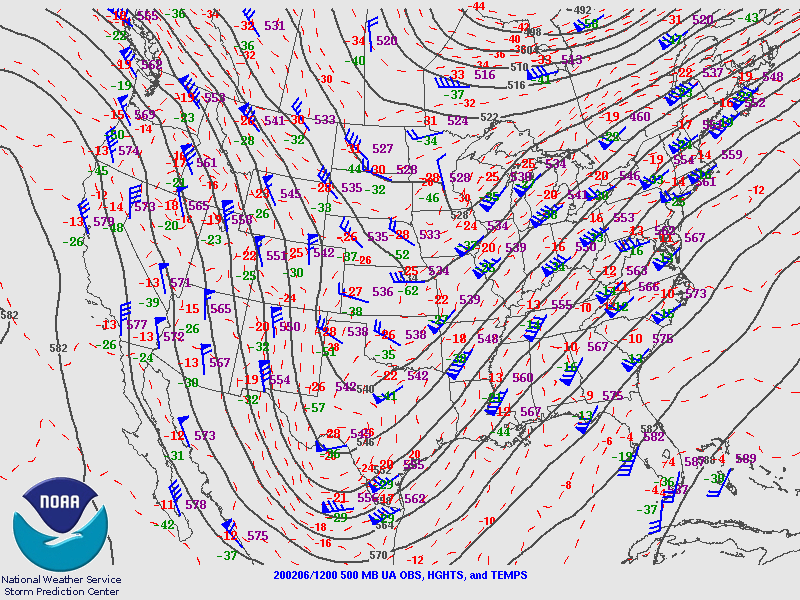
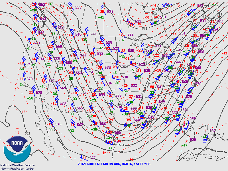
Upper level Synoptic Summary.
 |
 |
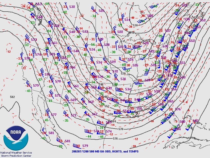 |
| 2-6 7 AM 500 mb Analysis | 2-6 7 PM 500 mb Analysis | 2-7 7 AM 500 mb Analysis |
Surface Synoptic Summary.
 |
 |
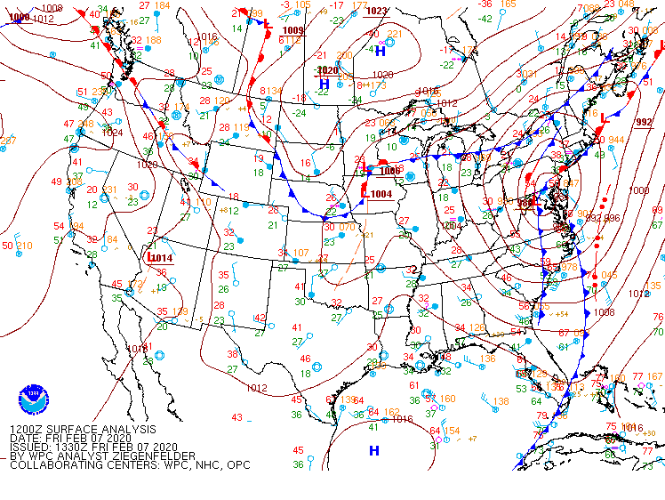 |
| 2-6 7 AM Surface Analysis | 2-6 1 PM Surface Analysis | 2-7 7 AM Surface Analysis |
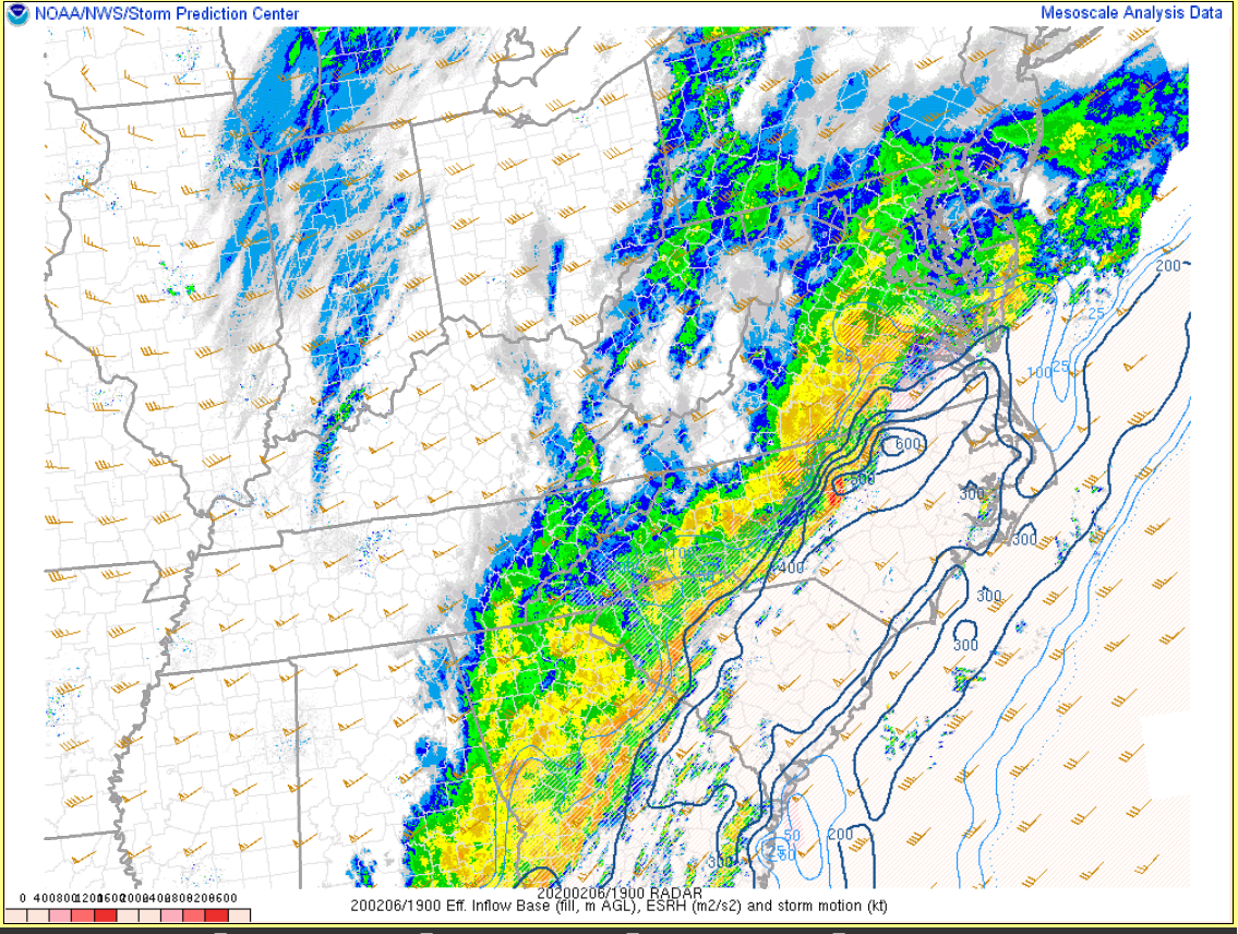
Mid Afternoon (2-6 2 PM) Parameters:
 |
 |
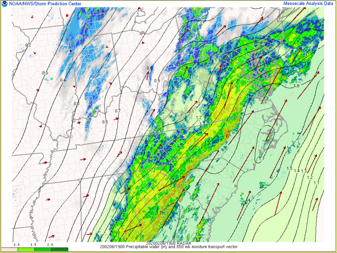 |
| 2 PM MLCAPE/CIN | 2 PM Effective Storm Relative Helicity | 2 PM Precipitable Water |
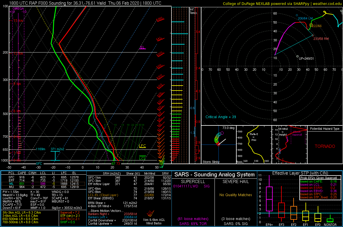
Sounding Data from 2-6.
 |
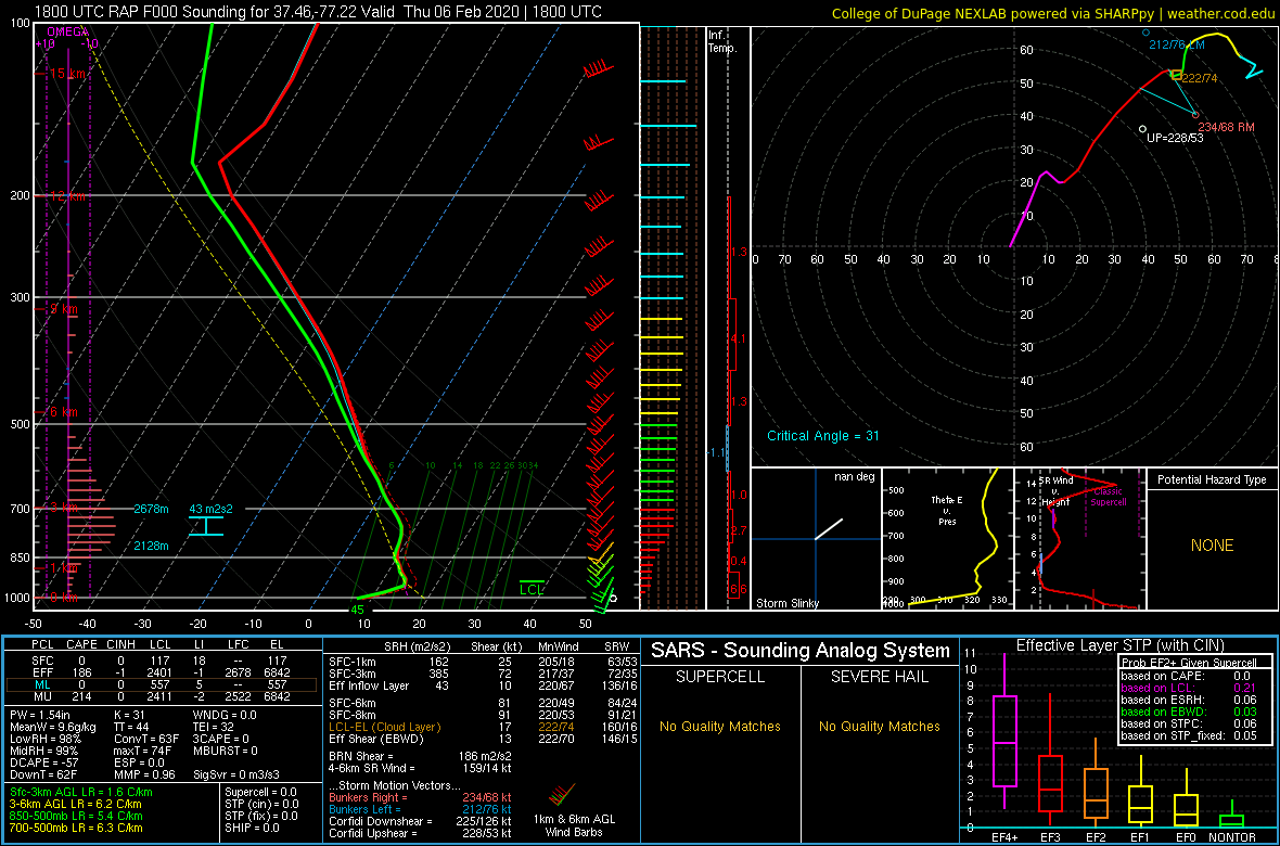 |
| 18z/1 PM RAP Analysis Sounding from Gates County, NC | 18z/1 PM RAP Sounding from KRIC |
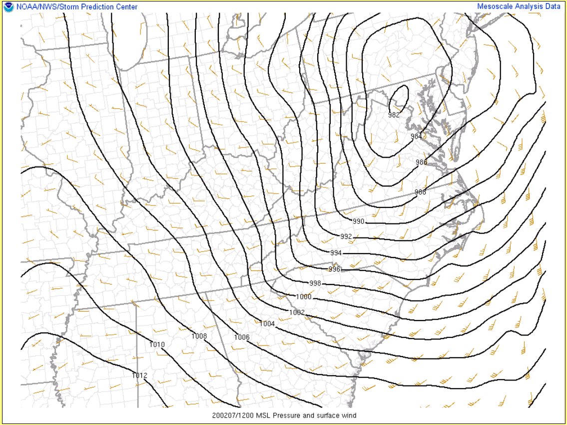
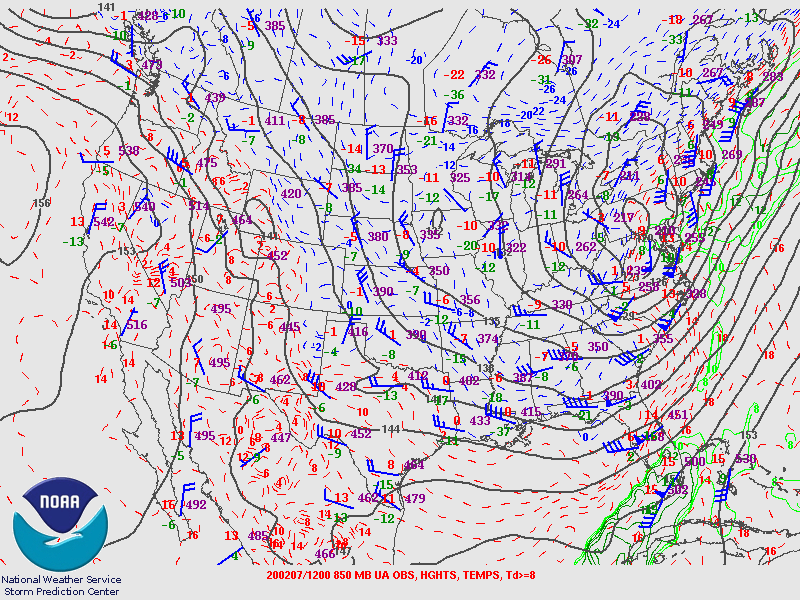
Selected Parameters from 7 AM on 2-7. See synoptic overview above for surface/500 mb maps from the morning of 2-7.
 |
 |
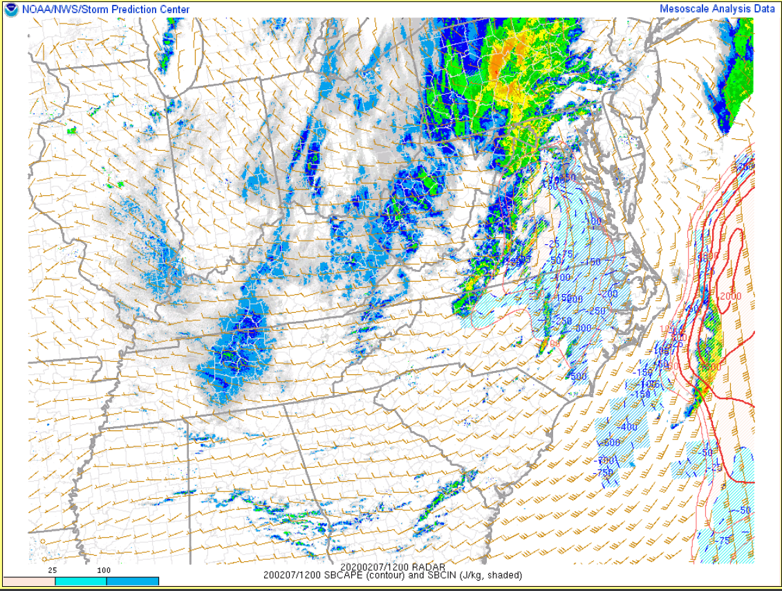 |
| MSLP/Wind | 850 mb Analysis | SBCAPE/CIN |
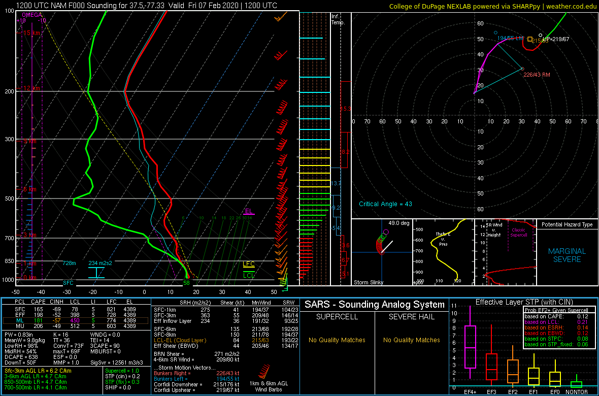
Sounding Data from 2-7.
 |
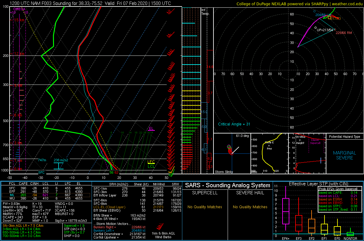 |
| 12z/7 AM NAM Analysis Sounding from KRIC | 15z/10 AM 3-h NAM Forecast Sounding from KSBY |
 |
Media use of NWS Web News Stories is encouraged! Please acknowledge the NWS as the source of any news information accessed from this site. |
|


 Coastal Flood
 Heat
Heat