Overview
Brief Overview: A strong cold front passed through the area during the day on February 11th while an Arctic airmass was in place from southern Canada to the Plains and Midwest. During the evening of February 11th, ~1045 mb high pressure was analyzed over the western Canadian Prairies. This Arctic airmass was slowly pushing southward toward our area. Meanwhile, a broad upper trough was over the central CONUS, with southwesterly flow aloft present from the western Gulf coast to the Mid-Atlantic. This allowed for warm, moist air aloft to override the shallow cold airmass near the surface. Several disturbances in the flow aloft helped to provide the lift necessary for snow/ice across the region while weak surface lows tracked well to our south. This resulted in bands of moderate to heavy snow to stream across areas from the central VA Piedmont to the VA Eastern Shore during the evening of the 11th through the early morning on the 12th. 4 to 5 inches of snow was observed in a narrow area in these locations. Further south, a mix of snow/sleet/freezing rain was observed from late on the 11th through the morning of the 12th. Up to 0.20" of ice accretion was observed in areas in/near the south-central VA Piedmont. 1-2" of snow/sleet was observed across southern portions of the Richmond Metro. The active pattern continued, as another series of upper disturbances traversed the area during the day on the 13th. With much warmer air aloft, precipitation was either freezing rain or rain across the area. This resulted in an additional 0.25-0.40" (locally ~0.50") of ice across western portions of the area. Combined with the ice and snow that had fallen on the 11th-12th, this resulted in widespread power outages (worst impacts across central/south-central VA west of I-95). In multiple counties, over 90% of customers were without power. Outages lasted days, and are still ongoing in some locales. Combined with the icing observed on Feb 11-12, these were the worst icing impacts in parts of our area in over two decades.
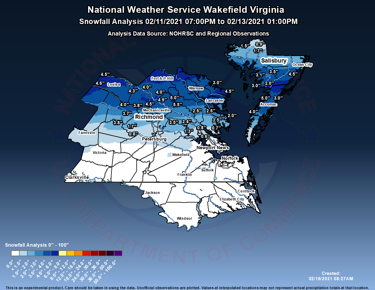
Snow Totals and Event Overview
Feb 11-12 Snow Overview: A large area of precipitation quickly overspread the area during the afternoon and evening on February 11th. This initially started as rain, but quickly changed to snow in areas north of Richmond during the evening as the Arctic airmass slowly filtered in. Surface temperatures dropped to 27-31°F across the majority of the area by early Friday morning (2/12). Precipitation stayed in the form of rain across far SE VA and NE NC. However, colder air aloft did not make it past the Richmond metro/Middle Peninsula/Accomack County. Therefore, precipitation changed to sleet and freezing rain across those areas as temperatures fell. In some parts of the area, precipitation briefly changed to snow before turning back to sleet/freezing rain as warmer air aloft started to inch back northward during the latter part of the night (see 850 mb analysis in Environment Section). Moderately strong frontogenesis likely contributed to some heavier banding just north of the RIC metro into Accomack County (these areas remained as snow and never changed back to sleet/freezing rain).
Ice Totals and Event Overview
Feb 13 Ice Storm: Warmer air aloft surged northward by the early morning of the 13th. Despite this, the center of the Arctic High had migrated SE into the Upper Midwest, and continued to ridge into the Northeast, Mid-Atlantic, and Carolinas. Another one of the aforementioned upper disturbances was approaching the area. Temperatures were in the 28-30°F across the western two-thirds of the area by the early morning hours of the 13th as another large area of precipitation was approaching from the south. In addition, NNE winds were able to tap into colder/drier air in Maryland and Pennsylvania. This was entirely in the form of freezing rain for much of the area at the onset (even into Surry/Southampton Counties in Virginia and Worcester County in Maryland). Ample warm, moist air aloft allowed precipitable water values to rise to around 1.00" (even in areas where temperatures were below freezing). As temperatures slowly rose from SE to NW, the freezing rain turned to rain across most of the MD Eastern Shore, Northern Neck, Middle Peninsula, and interior SE VA. However, temperatures did not go higher than 30-32F across central/south-central VA and the VA Piedmont. This is where a true ice storm was observed. Slightly lower precipitation totals were observed across far NW portions of our area, where power outages peaked at 50-60% of a county's customers. The worst impacts were observed from the western Richmond Metro to the central/south-central VA Piedmont (west of I-95). This is where the higher precipitation totals were observed. In addition, ice was accumulating on trees that had already seen up to 0.20" of ice the night before, making the situation even worse. This is likely why 90-100% of customers lost power in several counties in the southwestern portion of the AKQ forecast area. Most of the precipitation exited by late afternoon, but one last round of light rain/freezing rain quickly moved across the area during the evening, resulting in perhaps a few hundredths of an inch of additional icing across northwestern portions of the area.

Photos
 |
 |
 |
 |
| Icing in Crewe, VA (credit: @wx_Jpeg - Twitter) |
Icing in Lunenburg County, VA (credit: @wx_Jpeg - Twitter) |
Icing in Lunenburg County, VA (credit: @wx_Jpeg - Twitter) |
Icing in Lunenburg County, VA (credit: @wx_Jpeg - Twitter) |
 |
 |
| Power Outages at Peak of Storm (credit: PowerOutage.us) | Power Outages on 2/15 (credit: PowerOutage.us) |
Radar and Observations
Selected Loops
 |
 |
| Radar Loop from 7 PM on Feb 11 to 7 AM on Feb 12 in 1 hour Increments | Loop of Observations from 7 PM on Feb 11 to 7 AM on Feb 12 |
 |
 |
| Radar Loop from 1 AM on Feb 13 to 4 PM on Feb 13 in 3 hour Increments | Loop of Observations from 1 AM to 7 PM on Feb 13 |
Storm Reports
...FREEZING RAIN REPORTS...

Location                     Amount    Time/Date       Lat/Lon

...Maryland...

...Dorchester County...
2 SSW East New Market        0.20 in   0500 PM 02/13   38.57N/75.93W

...Virginia...

...Chesterfield County...
1 ENE Chester                0.35 in   0156 PM 02/13   37.36N/77.42W
3 S Meadowville              0.30 in   0535 PM 02/13   37.33N/77.33W
2 WNW Midlothian             0.25 in   0121 PM 02/13   37.51N/77.68W
Meadowville                  0.25 in   0100 PM 02/13   37.37N/77.32W
5 E Moseley                  0.25 in   1107 AM 02/13   37.42N/77.68W

...City of Colonial Heights County...
1 NNE Colonial Heights       0.30 in   0128 PM 02/13   37.28N/77.39W

...Dinwiddie County...
2 NNW Addison                0.30 in   0410 PM 02/13   37.22N/77.51W
3 NNE Walkers                0.28 in   1241 PM 02/13   37.20N/77.68W
Ford                         0.25 in   1026 AM 02/13   37.15N/77.73W

...Hanover County...
1 SW Ashland                 0.30 in   0721 AM 02/14   37.76N/77.49W

...Henrico County...
2 WSW Dumbarton              0.40 in   0454 PM 02/13   37.60N/77.54W
Richmond International       0.29 in   0754 AM 02/13   37.51N/77.32W
1 WNW Short Pump             0.25 in   0245 PM 02/13   37.66N/77.62W
1 ENE Tuckahoe               0.25 in   1127 AM 02/13   37.59N/77.57W

...Louisa County...
3 WSW Waldrop                0.50 in   1258 PM 02/13   38.06N/78.25W

...Mathews County...
2 S Fort Nonsense            0.20 in   0800 AM 02/13   37.43N/76.44W

...Mecklenburg County...
South Hill                   0.20 in   0949 AM 02/13   36.73N/78.12W

...New Kent County...
2 WNW Colonial Downs         0.50 in   0536 PM 02/13   37.50N/77.05W

...Nottoway County...
3 NNE The Falls              0.30 in   0812 AM 02/13   37.08N/78.13W

...Prince George County...
1 W Prince George            0.35 in   0250 PM 02/13   37.22N/77.30W
2 SSE Fort Lee               0.35 in   0230 PM 02/13   37.21N/77.32W

...Southampton County...
2 SW Drewryville             0.20 in   0843 AM 02/13   36.69N/77.34W
--------------------------------------------------------------------------------------------------------------------
...SNOWFALL REPORTS...

Location                     Amount    Time/Date       Provider

...Maryland...

...Dorchester County...
2 SE East New Market         1.7 in    0536 AM 02/12   Emergency Mngr
1 SE Cambridge               1.5 in    0342 AM 02/12   Emergency Mngr
2 SW Hurlock                 0.9 in    0846 AM 02/12   Public

...Somerset County...
1.0 NE Princess Anne         3.5 in    0800 AM 02/12   COOP
Princess Anne 2.1 SSW        3.1 in    1050 AM 02/12   COCORAHS
Marion Station 1.7 S         3.0 in    0625 AM 02/12   COCORAHS
2 NNW Marion Station         2.0 in    0541 AM 02/12   Trained Spotter

...Wicomico County...
1 NNE Lakewood               2.1 in    0850 AM 02/12
Parsonsburg 1.6 WNW          1.5 in    0700 AM 02/12   COCORAHS
Salisbury                    1.5 in    0431 AM 02/12   Public

...Worcester County...
Snow Hill                    4.5 in    0730 AM 02/12   Broadcast Media
1 SE West Ocean City         3.0 in    0408 AM 02/12   Public
Berlin                       2.6 in    0947 AM 02/12   Public

...Virginia...

...Accomack County...
Onley 0.6 SE                 6.0 in    0800 AM 02/12   COCORAHS
1 W Bloxom                   5.0 in    0800 AM 02/12   Public
Pungoteague                  4.0 in    0700 AM 02/12   Emergency Mngr
Metompkin 0.9 SE             3.0 in    0700 AM 02/12   COCORAHS

...Caroline County...
Hanover 3.0 N                4.9 in    0700 AM 02/12   COCORAHS
4 NW Burruss Corner          4.0 in    0922 AM 02/12   Public
Penola                       4.0 in    0646 AM 02/12   Public

...Chesterfield County...
1 N Midlothian               2.5 in    0700 AM 02/12   Public
2 WNW Midlothian             2.1 in    0800 AM 02/12   NWS Employee
Midlothian 4.7 SSW           1.7 in    0700 AM 02/12   COCORAHS
3 SSW Midlothian             1.2 in    0821 AM 02/12   Public
Chesterfield 8.5 WSW         0.8 in    0700 AM 02/12   COCORAHS

...City of Richmond...
3 N Downtown Richmond        3.0 in    0705 AM 02/12   Public
1 SW Downtown Richmond       2.5 in    0823 AM 02/12   Broadcast Media
Richmond 1.1 SE              2.5 in    0700 AM 02/12   COCORAHS
Richmond 4.2 NNE             2.5 in    0700 AM 02/12   COCORAHS
2 E Downtown Richmond        2.0 in    0600 AM 02/12   NWS Employee

...City of Williamsburg...
Williamsburg 1.0 SSW         0.6 in    0600 AM 02/12   COCORAHS

...Essex County...
1 NNE Tappahannock           4.5 in    0420 AM 02/12   Public

...Gloucester County...
Glenns                       2.5 in    0700 AM 02/12   Public
Gloucester Courthouse 3.3 SS 0.7 in    0800 AM 02/12   COCORAHS
Gloucester Point 2.4 E       0.1 in    0700 AM 02/12   COCORAHS

...Goochland County...
Manakin-Sabot 1.6 SW         3.7 in    0700 AM 02/12   COCORAHS

...Hanover County...
1 WNW Mechanicsville         5.0 in    0700 AM 02/12   Public
1 NNE Ashcake                4.5 in    0818 AM 02/12
Ashland                      4.5 in    0600 AM 02/12   Public
2 S Vontay                   4.0 in    0553 AM 02/12   Public

...Henrico County...
1 N Solomons Store           4.0 in    0700 AM 02/12   Trained Spotter
Henrico 5.8 W                3.9 in    0845 AM 02/12   COCORAHS
Short Pump                   3.8 in    0630 AM 02/12   Trained Spotter
Glen Allen 4.6 W             3.7 in    0704 AM 02/12   COCORAHS
Richmond International       2.6 in    0700 AM 02/12   Official NWS Obs
Richmond 5.3 NW              2.5 in    0700 AM 02/12   COCORAHS
Richmond 4.8 N               2.3 in    0700 AM 02/12   COCORAHS

...James City County...
Toano 1.1 SSW                1.3 in    0700 AM 02/12   COCORAHS
Williamsburg 6.5 NW          0.8 in    0700 AM 02/12   COCORAHS

...King William County...
1 E Aylett                   5.5 in    0710 AM 02/12   Public
Aylett                       5.0 in    0930 AM 02/12   Broadcast Media

...King and Queen County...
Mattaponi 2.6 NNW            2.5 in    0600 AM 02/12   COCORAHS

...Louisa County...
Gordonsville 10.4 S          4.6 in    0700 AM 02/12   COCORAHS
3 N Waldrop                  4.5 in    0825 AM 02/12   Public
Locust Creek                 4.3 in    0700 AM 02/12   Public

...Mathews County...
Gwynn                        2.0 in    1008 AM 02/12   Trained Spotter

...Middlesex County...
White Stone 8.0 SSW          2.5 in    0700 AM 02/12   COCORAHS

...New Kent County...
1 ESE Bottoms Bridge         3.5 in    0949 AM 02/12   Trained Spotter
Providence Forge 3.7 NE      2.4 in    0800 AM 02/12   COCORAHS

...Northampton County...
Eastville 5.0 NNW            0.4 in    0800 AM 02/12   COCORAHS

...Northumberland County...
1 W Lilian                   4.5 in    0700 AM 02/12   Public
Lottsburg 2.3 NNE            3.0 in    0700 AM 02/12   COCORAHS

...Powhatan County...
3 SSE Worshams               3.8 in    0529 AM 02/12   Public

...Prince Edward County...
Farmville 1.0 SSW            1.1 in    0700 AM 02/12   COCORAHS

...Prince George County...
1 ESE Petersburg National Ba 0.5 in    0827 AM 02/12   Public
1 SW Birchett Estate         0.3 in    0829 AM 02/12   NWS Employee
2 SSE Fort Lee               0.2 in    1045 AM 02/12   Public
&&
Environment
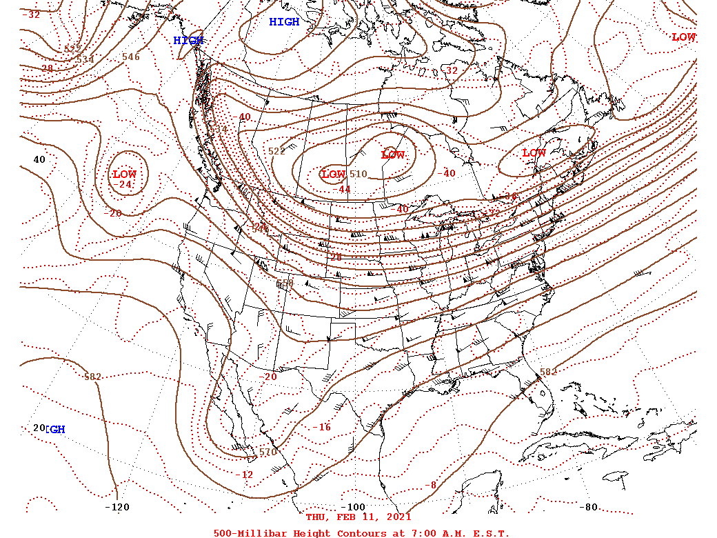
Upper Level Synoptic Summary.
 |
 |
 |
| 2/11 7 AM 500 mb Analysis | 2/12 7 AM 500 mb Analysis | 2/13 7 AM 500 mb Analysis |
Synoptic Surface Summary.
 |
 |
 |
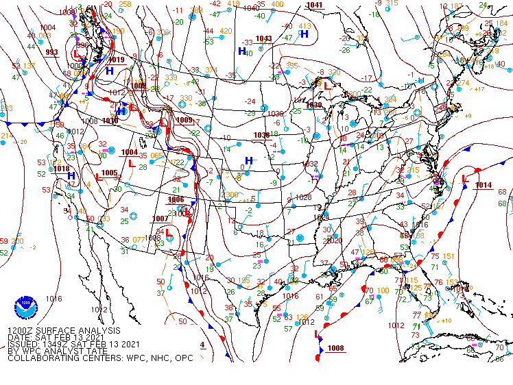 |
| 2/11 7 PM WPC Surface Analysis | 2/12 7 AM WPC Surface Analysis | 2/12 7 PM WPC Surface Analysis | 2/13 7 AM WPC Surface Analysis |
 |
 |
 |
 |
| Loop of 850 mb Analysis from 7 PM 2/11 to 7 AM 2/12 | Loop of 925 mb Analysis from 7 PM 2/11 to 7 AM 2/12 | Loop of 850 mb Analysis from 4 AM to 1 PM on 2/13 | Loop of 925 mb Analysis from 4 AM to 1 PM on 2/13 |
Additional environmental data.
 |
 |
 |
 |
| 7 AM 2/13 FVX (Farmville, VA) NAM Analysis Sounding | 7 AM 2/13 RIC (Richmond, VA) NAM Analysis Sounding | 7 AM 2/13 AKQ (Wakefield, VA) NAM Analysis Sounding | 1 PM 2/13 Precipitable Water and 850 mb Moisture Transport |
 |
Media use of NWS Web News Stories is encouraged! Please acknowledge the NWS as the source of any news information accessed from this site. |
|


 Coastal Flood
 Heat
Heat