Overview
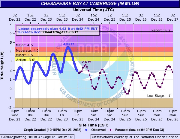
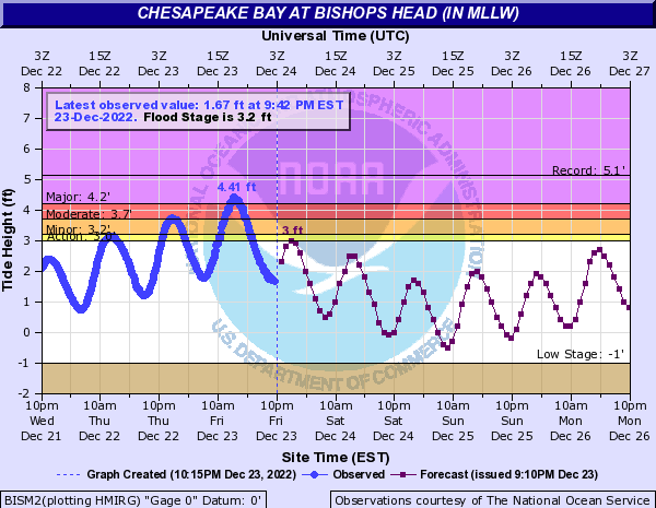
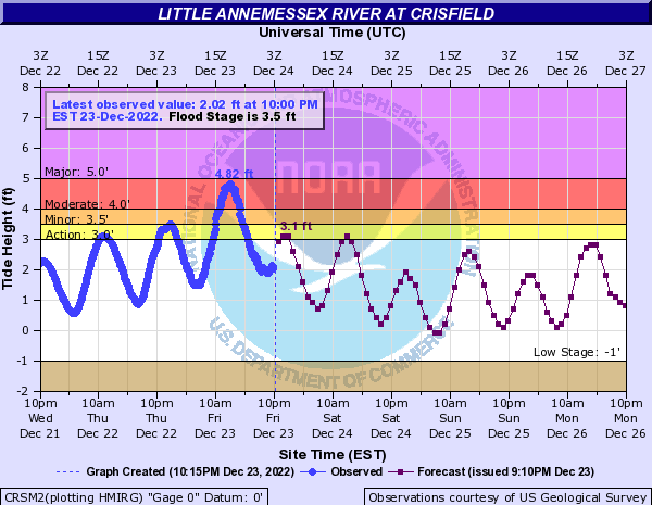
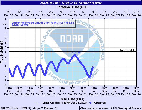
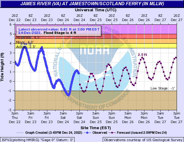
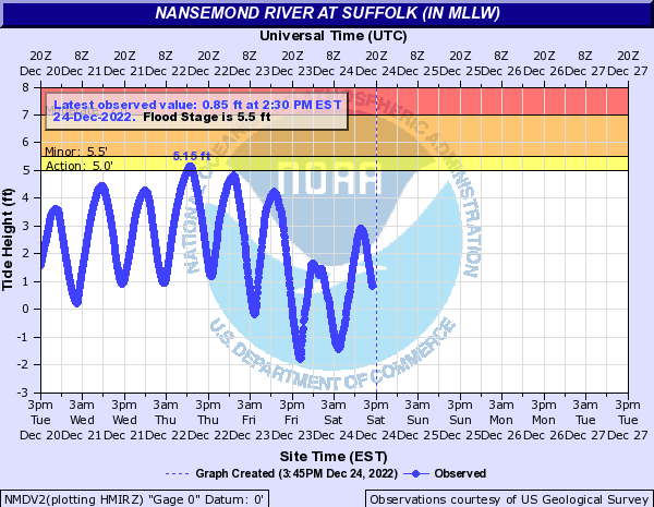
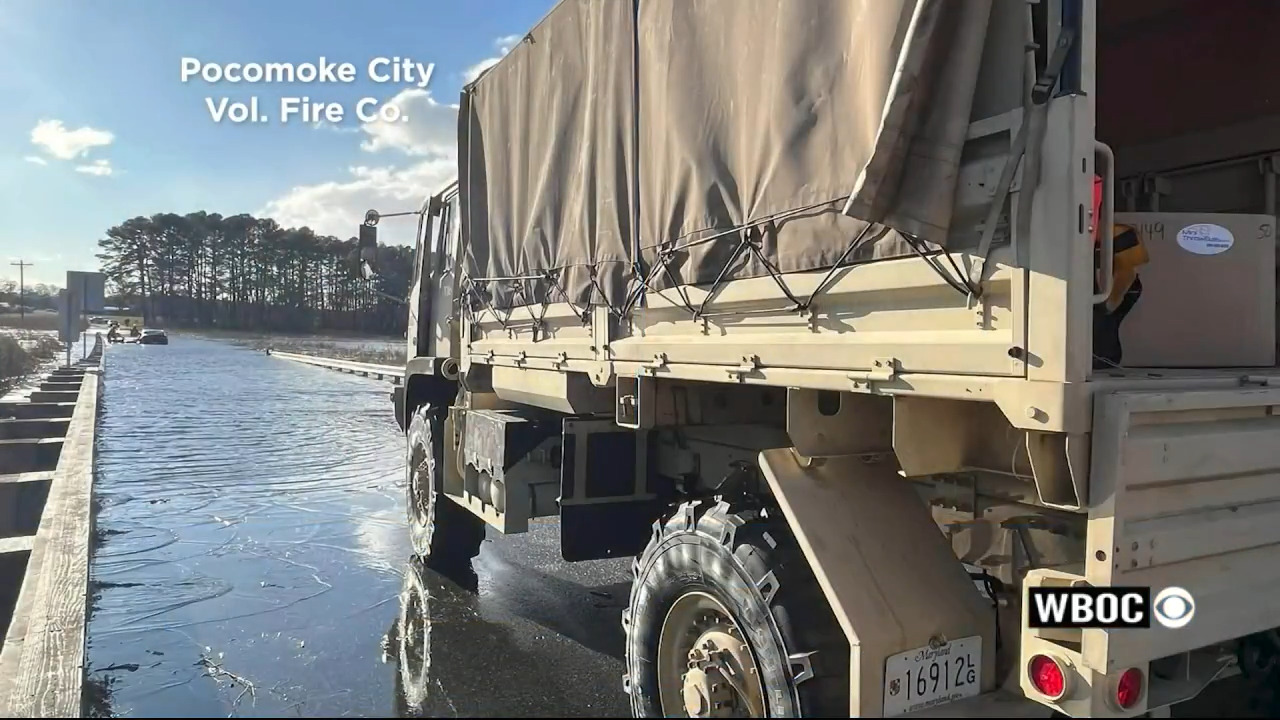
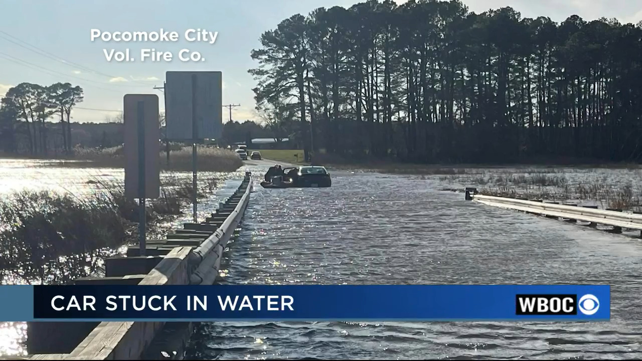
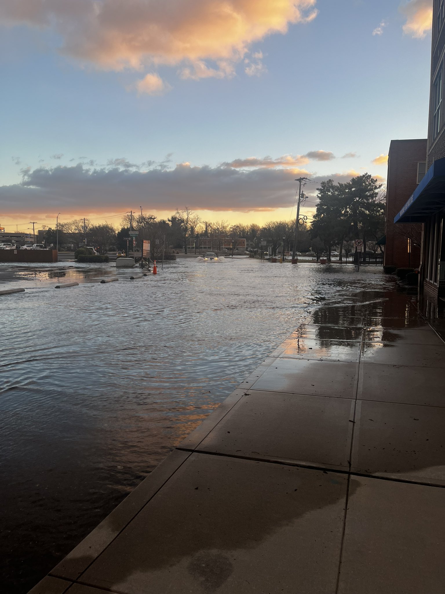
Intense low pressure rapidly deepened over the Great Lakes on the 23rd of December. This feature dragged an Arctic cold front through the area during the day on the 23rd. A moderately strong SE-SW wind was observed ahead of the front (for the preceding 12-24 hours), and allowed for water levels to build up in the Chesapeake Bay. No worse than minor flooding was observed the night of the 22nd into the early morning on the 23rd in areas adjacent to the mid/upper bay. After the Arctic frontal passage during the morning of the 23rd, winds became W-SW at 20-35 mph with a few gusts as high as 50-60 mph (although prevailing gusts were generally 40-45 mph). This allowed for water levels to rapidly rise on the bay side of the Lower Eastern Shore (on the other hand, water levels rapidly fell on the west side of the bay and along the Atlantic coast). Water levels crested well above moderate flood thresholds at Cambridge, Bishop's Head, Crisfield, and Saxis during the afternoon high tide. Levels even exceeded major flood thresholds at Bishop's Head and Cambridge. Several pictures from the coastal flooding are in the "Photos" section of this event review. It is also important to note that coastal flooding was observed in Downtown Salisbury (along the tidal Wicomico River) and also in Pocomoke City (along the tidal Pocomoke River). Low water thresholds (-1 ft MLLW) were exceeded along the tidal James/Nansemond Rivers in addition to areas adjacent to the Lower Chesapeake Bay and Atlantic coast of SE VA/NE NC.Flooding
Hydrographs
 |
 |
 |
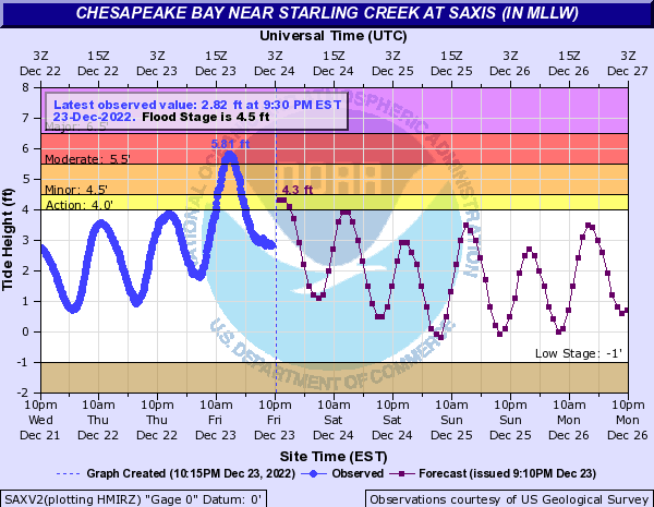 |
| Cambridge, MD | Bishop's Head, MD | Crisfield, MD | Saxis, VA |
Radar/Photos
 |
 |
 |
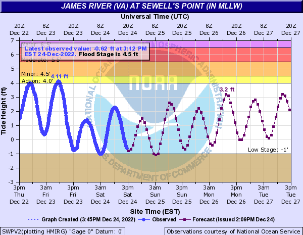 |
| Sharptown, MD | Jamestown, VA | Nansemond River near Suffolk,VA | Sewell's Point, VA |
Photos
Flooding Photos from Crisfield, MD
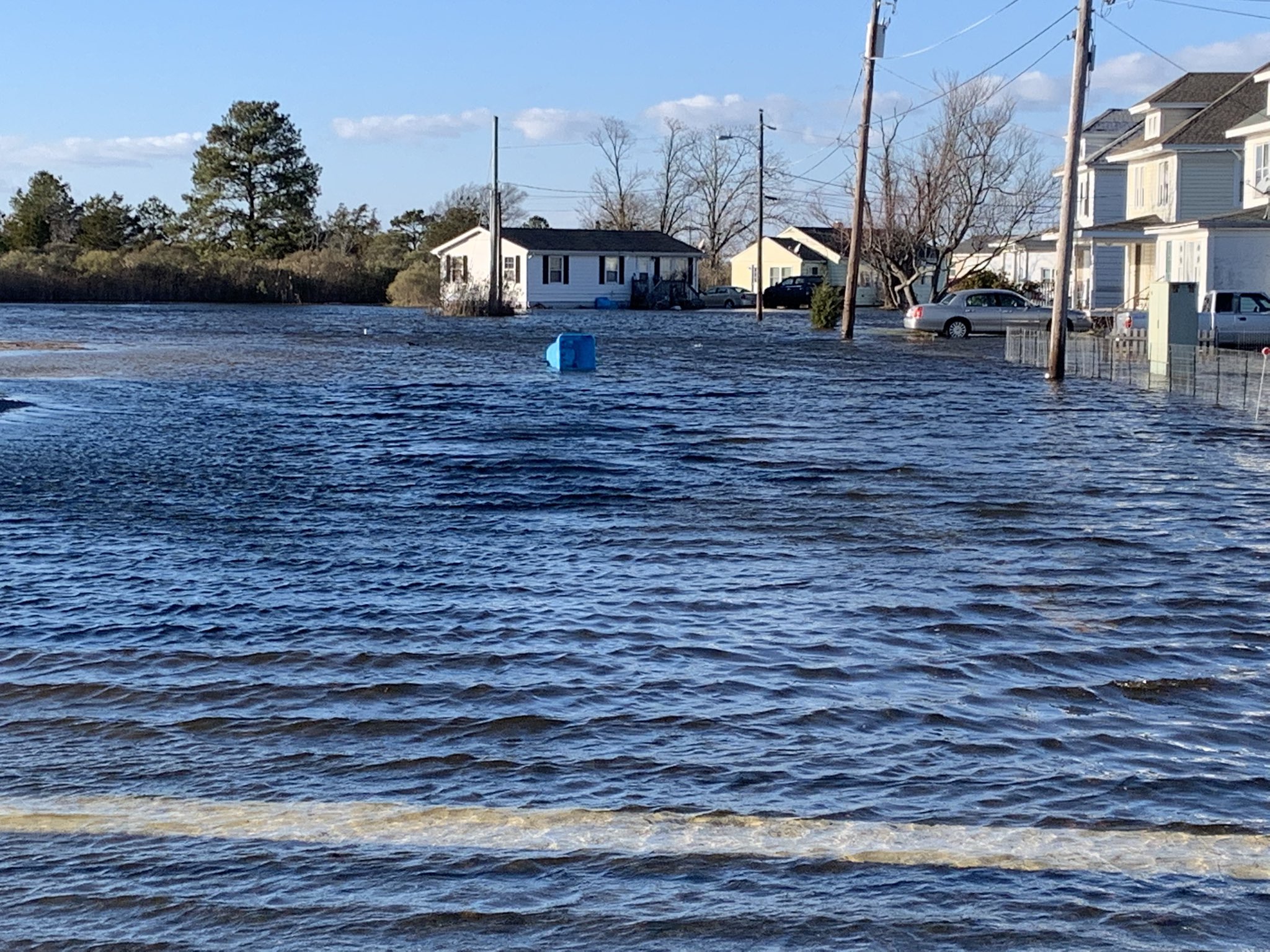 |
 |
 |
 |
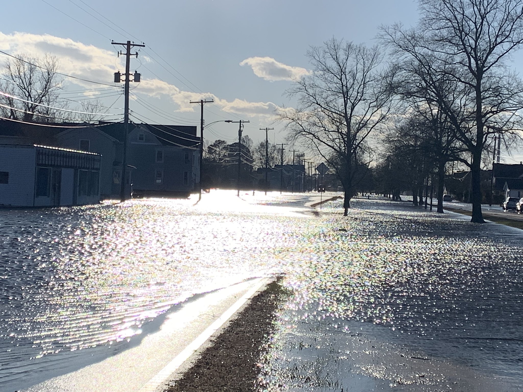
Additional Flooding Photos
 |
 |
 |
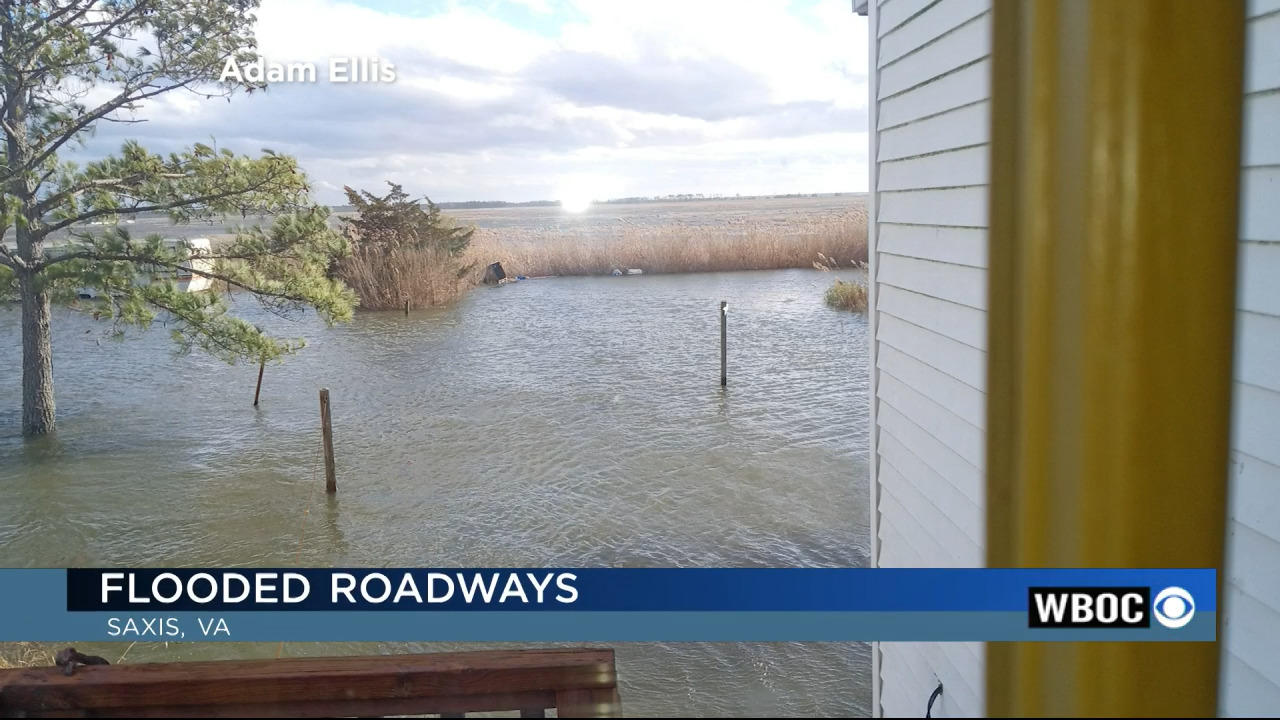 |
| Flooding in Pocomoke City, MD | Flooding in Pocomoke City, MD | Flooding on Market St in Salisbury, MD | Flooding in Saxis, VA |
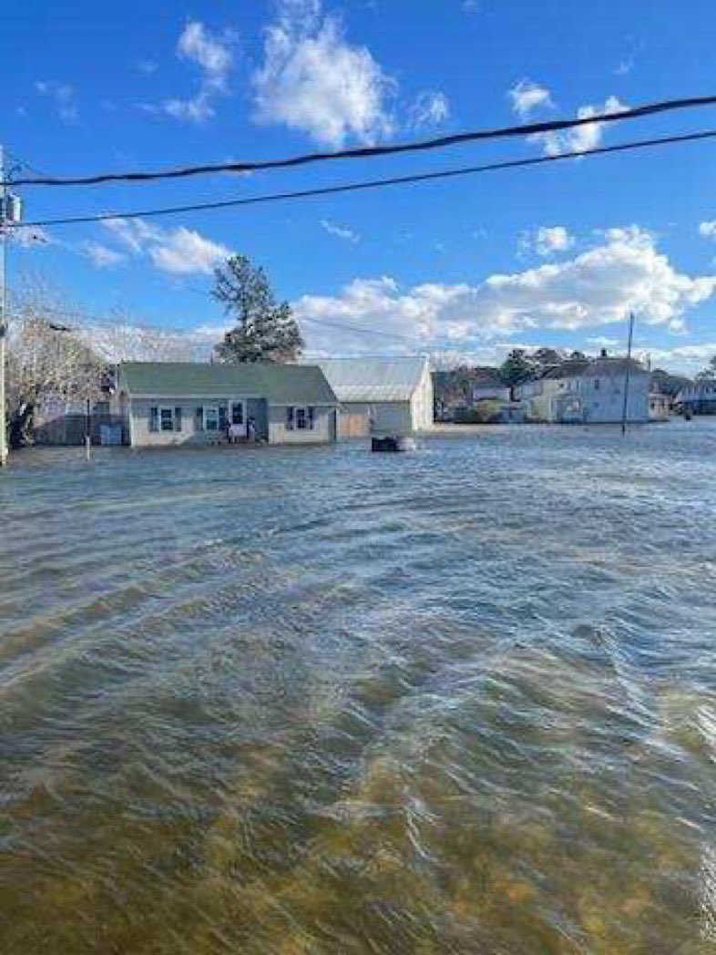
More Flooding Photos
 |
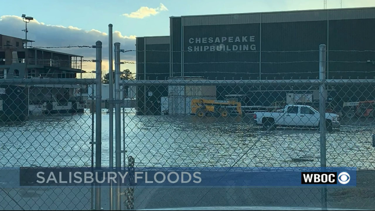 |
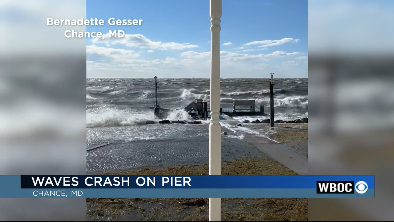
| Flooding in Chance, MD (Somerset County) | More Flooding in Salisbury, MD |
Wind Reports
Public Information Statement
National Weather Service Wakefield VA
1230 PM EST Fri Dec 23 2022

...HIGHEST WIND REPORTS...

Location                     Speed     Time/Date       Lat/Lon

...Maryland...

...Dorchester County...
Us-50 At Choptank            44 MPH    0934 AM 12/23   38.58N/76.06W

...Wicomico County...
Us-13 At Us-50               47 MPH    1024 AM 12/23   38.37N/75.54W
Salisbury Wicomico Airport   46 MPH    1024 AM 12/23   38.33N/75.50W

...Worcester County...
Ocean City                   51 MPH    1056 AM 12/23   38.32N/75.12W
Us-13 At Us-113              42 MPH    1024 AM 12/23   38.06N/75.55W
Us 50 Eb On Oc Drawbridge Wi 42 MPH    1049 AM 12/23   38.33N/75.09W

...North Carolina...

...Bertie County...
Peanut Belt Research Station 49 MPH    0930 AM 12/23   36.13N/77.18W
Greens Cross                 40 MPH    1117 AM 12/23   36.02N/76.89W

...Chowan County...
Edenton                      52 MPH    1015 AM 12/23   36.02N/76.57W

...Currituck County...
Corolla                      56 MPH    1100 AM 12/23   36.30N/75.80W
3.0 E Knotts Island (WEATHER 53 MPH    1000 AM 12/23   36.52N/75.87W
1.6 NW Moyock (WEATHERSTEM)  52 MPH    1040 AM 12/23   36.50N/76.16W
3.4 S Corolla (WEATHERSTEM)  45 MPH    1100 AM 12/23   36.33N/75.81W
0.5 E Jarvisburg (WEATHERSTE 45 MPH    1100 AM 12/23   36.20N/75.86W
Currituck                    44 MPH    1115 AM 12/23   36.40N/76.02W

...Hertford County...
Ahoskie Tri Coun             40 MPH    1055 AM 12/23   36.28N/77.17W

...Northampton County...
Conway                       62 MPH    0910 AM 12/23   36.43N/77.23W

...Perquimans County...
Hertford                     60 MPH    1030 AM 12/23   36.16N/76.32W
Chapanoke                    52 MPH    1025 AM 12/23   36.24N/76.36W

...Virginia...

...Accomack County...
Wallops Island               53 MPH    1022 AM 12/23   37.93N/75.47W
Melfa Accomack               40 MPH    1015 AM 12/23   37.63N/75.77W

...Brunswick County...
South Hill Meckl             44 MPH    1055 AM 12/23   36.68N/78.03W
Lawrenceville                39 MPH    0815 AM 12/23   36.78N/77.80W

...Chesterfield County...
Richmond Chester             45 MPH    1055 AM 12/23   37.40N/77.52W
Thomas Dale High School      42 MPH    0820 AM 12/23   37.36N/77.44W

...City of Chesapeake County...
Chesapeake                   49 MPH    1015 AM 12/23   36.67N/76.32W
Norfolk Hampton              41 MPH    0935 AM 12/23   36.78N/76.45W
Chesapeake                   35 MPH    1116 AM 12/23   36.83N/76.40W

...City of Hampton County...
Langley AFB Hamp             59 MPH    1009 AM 12/23   37.07N/76.37W

...City of Newport News County...
Newport News                 53 MPH    1052 AM 12/23   37.13N/76.50W

...City of Norfolk County...
Norfolk Intl Airport         54 MPH    1003 AM 12/23   36.90N/76.20W
Norfolk NAS Cham             46 MPH    1011 AM 12/23   36.92N/76.27W
Norfolk                      42 MPH    1123 AM 12/23   36.86N/76.29W
Norfolk                      37 MPH    0959 AM 12/23   36.89N/76.21W

...City of Richmond County...
Richmond                     44 MPH    0806 AM 12/23   37.55N/77.47W

...City of Suffolk County...
Suffolk                      45 MPH    0935 AM 12/23   36.68N/76.60W
Gdr                          44 MPH    0954 AM 12/23   36.61N/76.55W
Suffolk                      41 MPH    1105 AM 12/23   36.60N/76.67W

...City of Virginia Beach County...
Oceana NAS Souce             61 MPH    1026 AM 12/23   36.82N/76.02W
Back Bay                     57 MPH    1054 AM 12/23   36.67N/75.92W
Virginia Beach               47 MPH    1035 AM 12/23   36.78N/76.14W
Virginia Beach               43 MPH    1020 AM 12/23   36.75N/75.99W

...Dinwiddie County...
Petersburg                   41 MPH    0835 AM 12/23   37.17N/77.52W

...Greensville County...
Emporia                      38 MPH    0835 AM 12/23   36.68N/77.48W

...Hanover County...
Richmond Hanover             43 MPH    1006 AM 12/23   37.70N/77.43W

...Henrico County...
Richmond Intl Airport        54 MPH    0939 AM 12/23   37.52N/77.32W

...Isle of Wight County...
Franklin J B Ros             44 MPH    0935 AM 12/23   36.70N/76.90W

...King and Queen County...
West Point                   41 MPH    1115 AM 12/23   37.52N/76.77W

...Louisa County...
Louisa                       44 MPH    0955 AM 12/23   38.02N/77.97W

...Mathews County...
North                        37 MPH    0930 AM 12/23   37.45N/76.45W

...Mecklenburg County...
Clarksville                  43 MPH    1055 AM 12/23   36.60N/78.55W

...Northumberland County...
Lewisetta, VA                39 MPH    1106 AM 12/23   38.00N/76.46W

...Nottoway County...
Blackstone Fort              47 MPH    1035 AM 12/23   37.07N/77.95W
Crewe                        41 MPH    0955 AM 12/23   37.18N/78.10W

...Sussex County...
Norfolk Wakefld              40 MPH    0902 AM 12/23   36.98N/77.00W

...Maritime Stations...
Middle Ground Lighthouse     57 MPH    0950 AM 12/23   36.95N/76.39W
Rudee Inlet                  49 MPH    1040 AM 12/23   36.83N/75.97W
8 NW Cape Henry              48 MPH    1042 AM 12/23   37.03N/76.08W
Machipongo                   43 MPH    1008 AM 12/23   37.41N/75.97W
&&
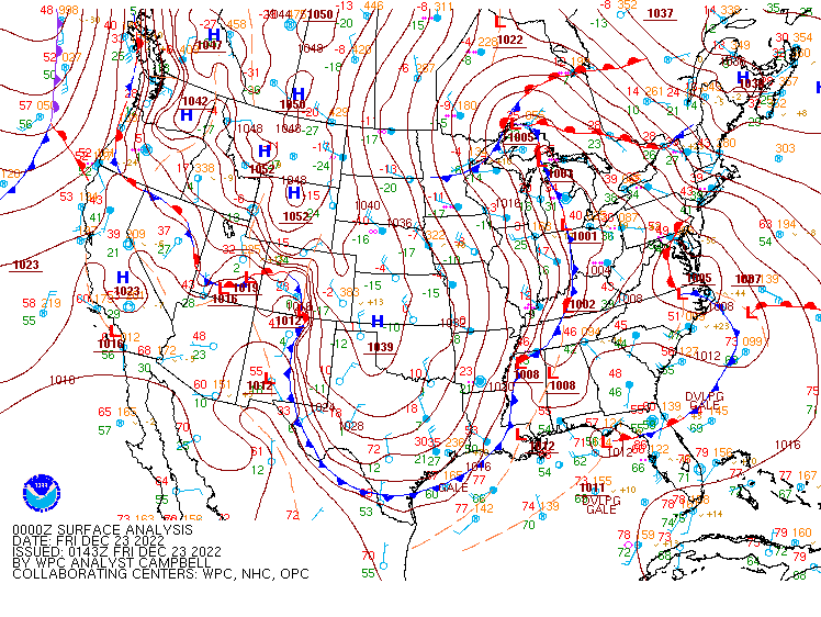
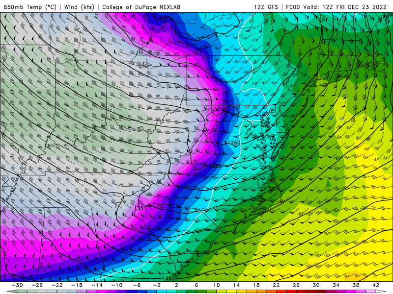
Environment
Synoptic summary.
 |
| Figure 1: Caption |
 |
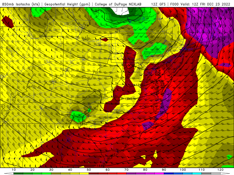 |
| GFS 850mb Temps/Winds | GFS 850mb Winds |
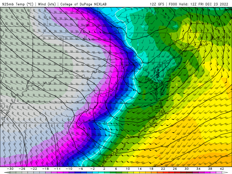
GFS 925mb Analyses from 12-18z in 3-h increments
 |
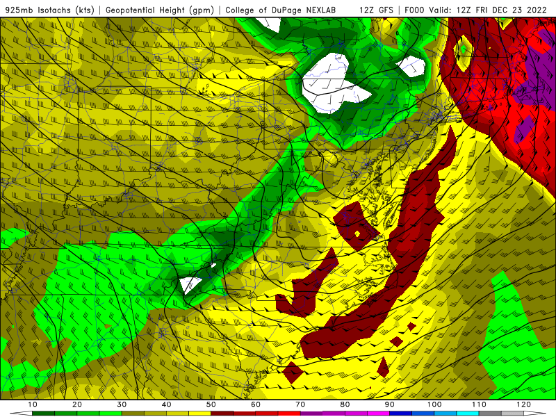 |
| GFS 925mb Temps/Winds | GFS 925mb Winds |
 |
Media use of NWS Web News Stories is encouraged! Please acknowledge the NWS as the source of any news information accessed from this site. |
|


 Coastal Flood
 Heat
Heat