
Scattered strong to severe thunderstorms are forecast over parts of Kansas, Oklahoma, and west Texas today and tonight, with damaging winds and large hail possible. A cold front pressing south across the central Plains will collide with moist southerly winds on Thursday bringing a risk for heavy to excessive rainfall and flooding. Read More >
Overview
General Summary: The day before making landfall in the CONUS (Sunday), TC Isaias was moving northward just east of the Florida coast. Meanwhile, an anomalously deep upper trough was centered over the MS River Valley with Bermuda high pressure (at the surface and aloft) well offshore of the VA/NC coast. Isaias continued to generally move northward just offshore of FL/GA/SC from Sunday night through the day on Monday as the aforementioned upper trough over the MS River Valley slowly moved eastward. Isaias made landfall Monday evening near Ocean Isle Beach in southeast North Carolina and would get picked up by the upper trough shortly thereafter. Rain (and a few thunderstorms) had already begun by Monday afternoon across the Wakefield forecast area as deep-layer moisture increased ahead of Isaias. Additionally, we were in the right entrance region of a 100-140 knot southwesterly upper (200-250 mb) jet on the east side of the trough. This placed our forecast area in a favorable region for upper divergence/lift which played a part in allowing for rain/t-storms to form well ahead of Isaias. Isaias would proceed to accelerate and track north-northeast through eastern NC and VA from Monday night through Tuesday morning as a strong tropical storm before quickly exiting to the NNE of the area by Tuesday afternoon.
The largest wind impacts were felt across eastern VA, northeast NC, and the Lower Eastern Shore, where S to SE wind gusts peaked at 65-75 mph. This downed several trees and power lines, resulting in widespread power outages (300,000+ at one point over eastern portions of the Wakefield forecast area). The heaviest rainfall shifted to along/just left of the track as Isaias interacted with the approaching upper trough. While flooding impacts were limited due to Isaias's fast movement, a widespread 2-5” of rain fell in most areas (locally 6”). The most impressive aspect regarding Isaias’s impacts on our area was the 15* tornadoes that were spawned across portions of eastern VA, NE NC, and the Lower MD Eastern Shore. There were multiple strong (EF2+) tornadoes. The EF-3 tornado in Bertie County was the first EF-3 tornado in the Wakefield forecast area since February 24, 2016. EF-3 tornadoes are quite rare in our forecast area, and are even rarer when associated with tropical cyclones. Storm surge impacts were minor in most surge prone areas, with the exception of the bay side of the Lower Eastern Shore and areas along the north side of the Albemarle/Currituck Sounds (including Back Bay in VA Beach). Moderate to locally major tidal flooding was observed in these areas. See below for additional details on the tornado/tidal flooding aspects of Isaias’s impact on our area.
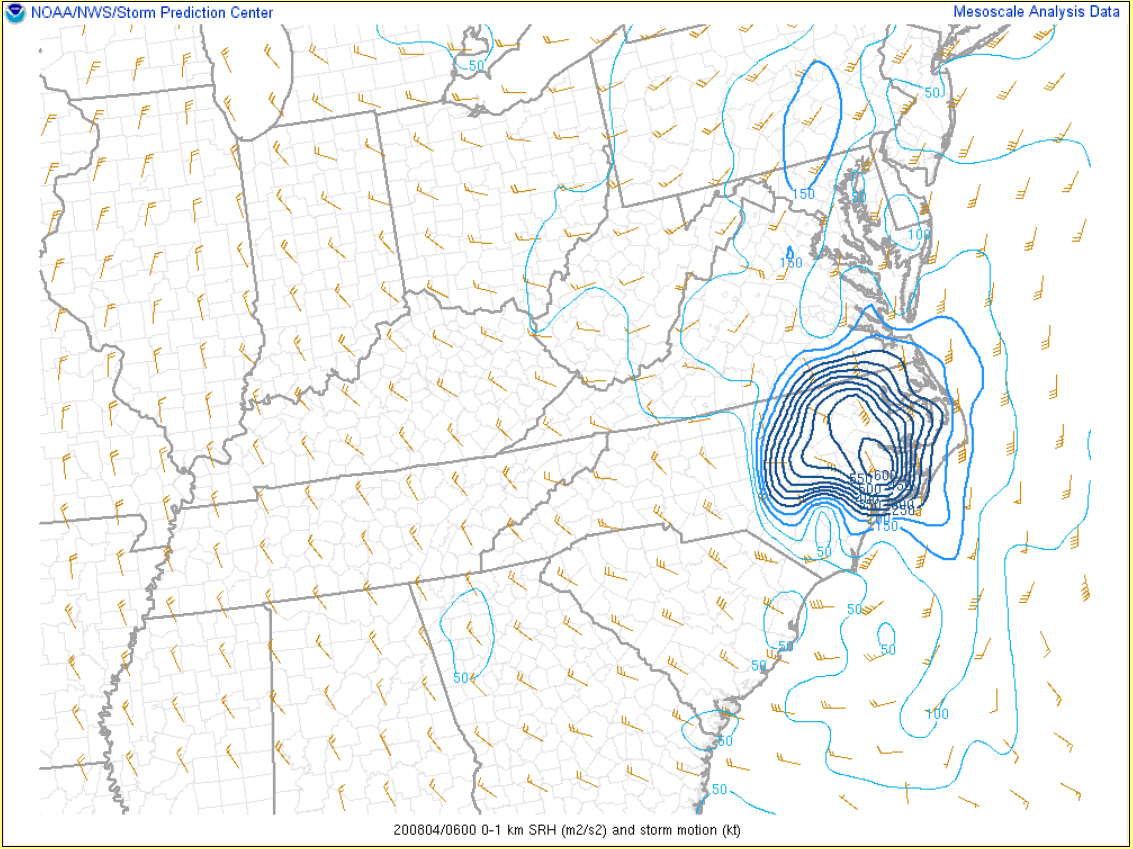
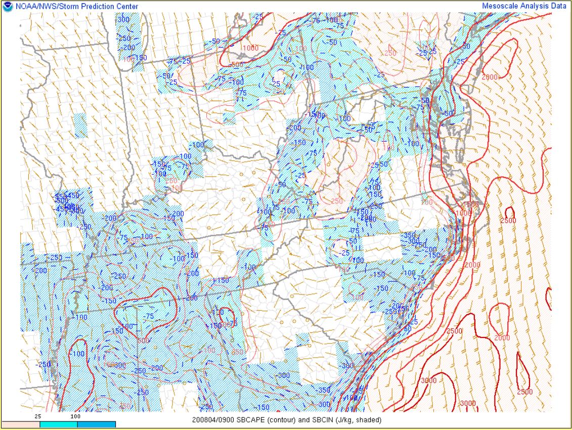
Tornadoes: As Isaias tracked to the NNE through the area early Tuesday morning, a north-south oriented surface boundary set up on the north side of the storm (just to the east of I-95). On the east side of the boundary, winds were mainly out of the SE with temperatures in the upper 70s-around 80F and surface dew points in the mid to upper 70s. To the west of the boundary, winds were generally out of the north with temperatures and dew points in the upper 60s-around 70F. As is typical with tropical storms, the boundary layer wind fields were extremely strong. Along and just east of the track, there were 60-80 knot south to southeast winds in the 925-850 mb layer. These strong winds allowed for 0-1 km SRH values to climb to extreme levels (400-600 m2/s2) in an area in the vicinity of the surface boundary just to the north and northeast of the center of Isaias where there was some additional backing in the surface wind field (see Environment section for images from 2 am and 5 am). In addition, there was impressive deep-layer shear owing to the presence of the strong upper jet on the east side of the trough. While there was little to no instability on the "cool" side of the boundary, the mid-upper 70s dew points helped contribute to 1000-2000 J/kg of SBCAPE east of the boundary. When one of the outer rain bands of Isaias (already containing mini supercells) moved into the unstable/extremely sheared airmass just to the east of the boundary, this resulted in several tornadoes (2 strong). The tornado reports were generally clustered in a SSW-NNE direction in an area within 75 miles of the location of the boundary in the northeast quadrant of Isaias. This one rain band was responsible for nearly all of the tornadoes.
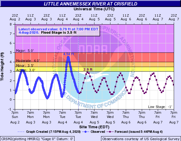
Storm Surge/Tidal Flooding: While the fast movement of Isaias prevented widespread moderate-major tidal flooding, strong S to SE winds resulted in moderate (perhaps some locally major) tidal flooding across NE NC north of the Albemarle/Currituck Sounds and Back Bay in VA Beach. Additionally, the strong S to SE winds allowed some water to pile up in the mid to upper Chesapeake Bay early Tuesday morning. Then, when winds shifted to more of a westerly direction on the southern flank of Isaias during the mid to late morning on Tuesday, water quickly got pushed into areas on the bay side of the Lower Eastern Shore (and water levels in these locations rose VERY rapidly). Moderate tidal flooding was observed in most areas from Bishop's Head to Crisfield to Saxis, with locally major flooding in Cambridge (where brief, strong WNW winds created near ideal conditions for water to surge down the Choptank River into Cambridge itself. See the Tidal Flooding section for hydrographs from selected locations.
*All tornado data is preliminary and subject to change.
Tornadoes:
|
Tornado - South of Woodard to Windsor, NC
Track Map  
|
||||||||||||||||
|
Tornado - South of Murfreesboro
Track Map 
|
||||||||||||||||
|
Tornado - Como NC
Track Map 
|
||||||||||||||||
|
Tornado - SE of Courtland to Sebrell, VA
Track Map 
|
||||||||||||||||
|
Tornado - DOWNTOWN SUFFOLK, VA
Track Map 
|
||||||||||||||||
|
Tornado - CITY OF SUFFOLK
Track Map 
|
||||||||||||||||
|
Tornado - GOVERNORS LAND AT TWO RIVERS
Track Map 
|
||||||||||||||||
|
Tornado - Middle Peninsula State Park
Track Map 
|
||||||||||||||||
|
Tornado - Kilmarnock
Track Map 
|
||||||||||||||||
|
Tornado - Mardela Springs MD
Track Map 
|
||||||||||||||||
|
Tornado - Fleeton
Track Map 
|
||||||||||||||||
|
Tornado - Stockton MD
Track Map  |
||||||||||||||||
|
Tornado - Quantico MD
Track Map  |
||||||||||||||||
|
Tornado - Berlin MD
Track Map 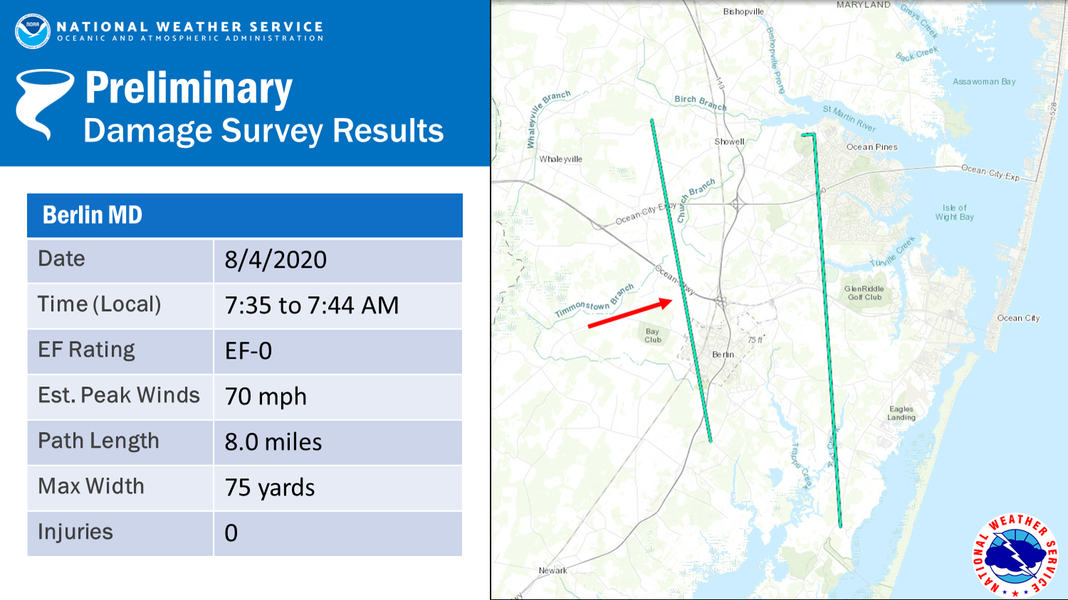
|
||||||||||||||||
|
Tornado - Ocean Pines MD
Track Map 
|
||||||||||||||||
The Enhanced Fujita (EF) Scale classifies tornadoes into the following categories:
| EF0 Weak 65-85 mph |
EF1 Moderate 86-110 mph |
EF2 Significant 111-135 mph |
EF3 Severe 136-165 mph |
EF4 Extreme 166-200 mph |
EF5 Catastrophic 200+ mph |
 |
|||||
Tidal Flooding
Hydrographs
 |
 |
 |
 |
| Water Levels at Cambridge, MD | Water Levels at Crisfield, MD | Water Levels at Saxis, VA | Water Levels at Edenton, NC |
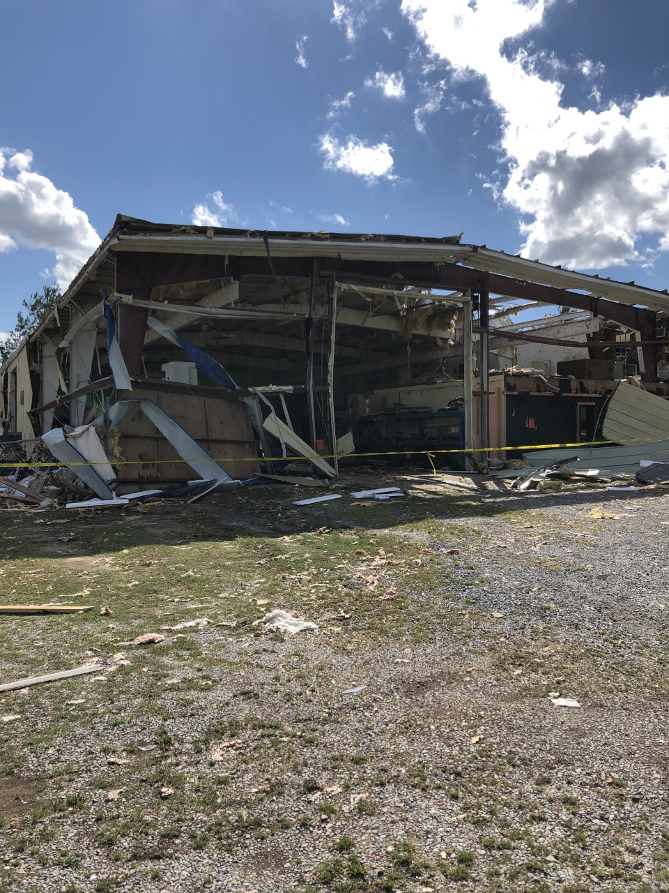
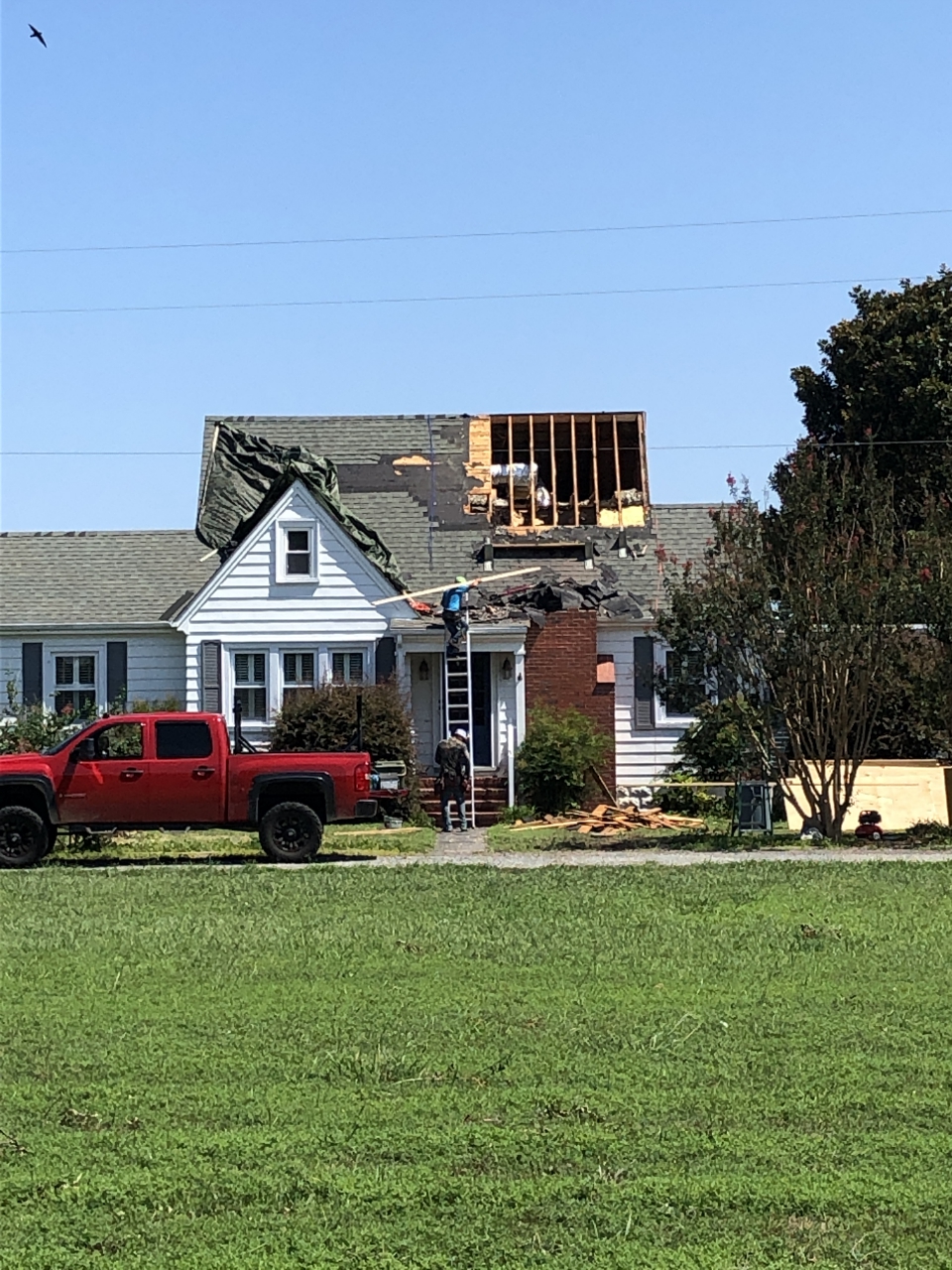
Photos
NWS Storm Survey Tornado Damage Photos
 |
 |
 |
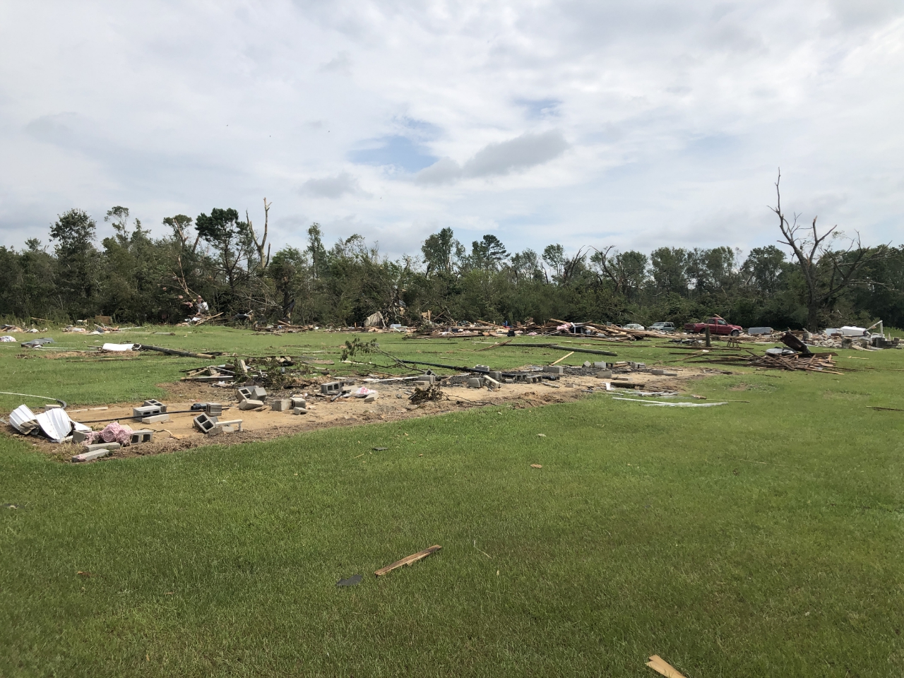 |
| Destruction of a mobile home in Bertie County, NC | Home debris in Bertie County, NC | Home debris in Bertie County, NC | Destruction of trailers in Bertie County, NC |
 |
 |
 |
 |
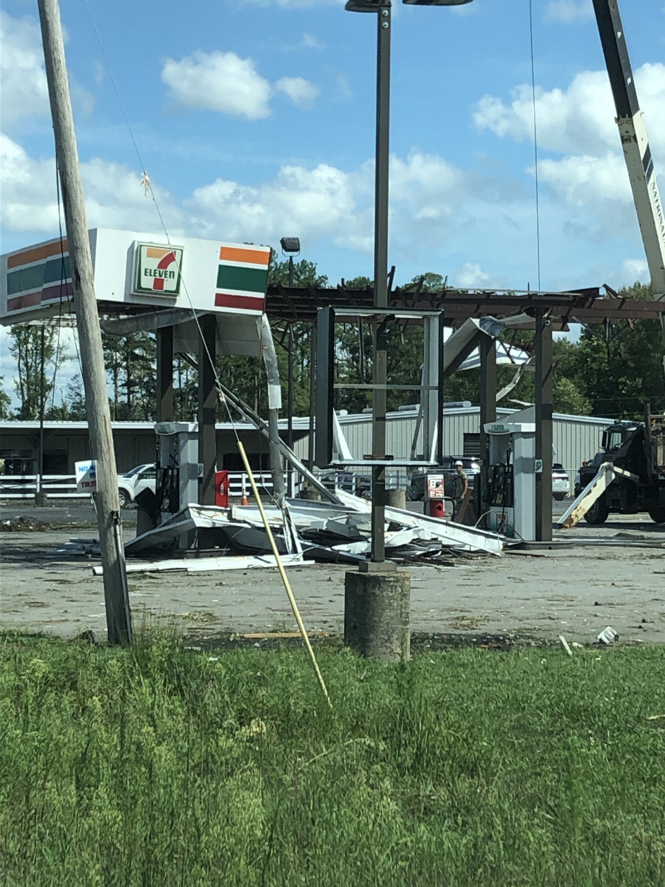
| Damage to apartments in Courtland, VA | Damage to a gas station in Courtland, VA | Damage to metal building in Courtland, VA | Damage to tractor business in Courtland, VA |
 |
 |
 |
 |
| Damage to garage in Fleeton, VA | Damage to a home in Fleeton, VA | Damage to a house in Kilmarnock, VA | Damage to a condo in Kilmarnock, VA |
 |
 |
 |
 |
| Damage in Mardela Springs, MD | Damage in Mardela Springs, MD | Drone footage of damage in Stockton, MD | Drone footage of damage in Stockton, MD |
 |
 |
 |
 |
| Damage to a building in Downtown Suffolk | Tree damage in Riverview area of Downtown Suffolk | Tree damage in Gloucester County, VA | Tree damage in Great Dismal Swamp in VA. |
Radar
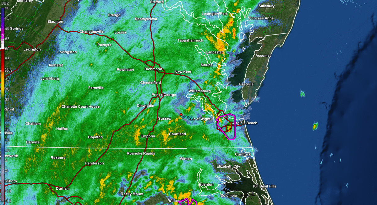 |
| Radar Loop with Tornado Warnings (~1 AM to 720 AM in ~10 minute increments). Note that a few tornadoes touched down on the Lower MD Eastern Shore in the hour after this radar image ends. |
 |
 |
| Loop of Bertie County mini supercell (that produced the EF-3 tornado) from 1:01-1:25 AM. Some descriptions regarding the tornado debris signature are present in the animation. Top left image is 0.5° Base Reflectivity, top right is Base Velocity, bottom left is Differential Reflectivity, and bottom right is Correlation Coefficient. | Loop of mini supercell that produced an EF-2 tornado in Courtland, VA. Top left image is 0.5° Base Reflectivity, top right is Base Velocity, bottom left is Differential Reflectivity, and bottom right is Correlation Coefficient. |
Wind/Rain Reports
 |
 |
| Max Wind Gusts from Isaias | Storm Total Rainfall from Isaias |
...HIGHEST WIND REPORTS...

Location                     Speed     Time/Date       Lat/Lon

...Maryland...

...Dorchester County...
Blackwater                   64 MPH    1126 AM 08/04   38.45N/76.09W
Cambridge, MD                59 MPH    1048 AM 08/04   38.57N/76.07W
Bucktown                     57 MPH    1030 AM 08/04   38.46N/76.04W
Blackwater                   57 MPH    1026 AM 08/04   38.45N/76.09W

...Somerset County...
2 W Marion Station           52 MPH    1028 AM 08/04   38.02N/75.77W

...Wicomico County...
Salisbury Wicomico Airport   61 MPH    0755 AM 08/04   38.33N/75.50W

...Worcester County...
Assateague Island            68 MPH    1040 AM 08/04   38.08N/75.20W
Assateague Island            65 MPH    0940 AM 08/04   38.08N/75.20W
Ocean City                   58 MPH    1049 AM 08/04   38.32N/75.12W
Ocean City                   56 MPH    0743 AM 08/04   38.32N/75.12W
1 SSW Ocean City             51 MPH    0930 AM 08/04   38.33N/75.08W

...North Carolina...

...Bertie County...
Greens Cross                 47 MPH    0517 AM 08/04   36.02N/76.89W

...Chowan County...
Edenton                      59 MPH    0535 AM 08/04   36.02N/76.57W

...Currituck County...
3.0 E Knotts Island (WEATHER 58 MPH    0720 AM 08/04   36.52N/75.87W
1.6 NW Moyock (WEATHERSTEM)  55 MPH    0720 AM 08/04   36.50N/76.16W
Corolla                      55 MPH    0700 AM 08/04   36.30N/75.80W

...Northampton County...
Conway                       53 MPH    1210 PM 08/03   36.43N/77.23W

...Pasquotank County...
Elizabeth City Airport       64 MPH    0625 AM 08/04   36.27N/76.18W
Elizabeth City               60 MPH    0613 AM 08/04   36.35N/76.28W

...Perquimans County...
Chapanoke                    69 MPH    0635 AM 08/04   36.24N/76.36W
Hertford                     54 MPH    0630 AM 08/04   36.16N/76.32W

...Virginia...

...Accomack County...
Onancock                     70 MPH    0929 AM 08/04   37.65N/75.88W
Tangier Sound Light          70 MPH    0623 AM 08/04   37.79N/75.97W
Wallops Island               68 MPH    0913 AM 08/04   37.93N/75.47W
Wachapreague                 66 MPH    0848 AM 08/04   37.60N/75.69W
Wachapreague, VA             60 MPH    0906 AM 08/04   37.61N/75.69W
Melfa Accomack               54 MPH    0835 AM 08/04   37.63N/75.77W
Parksley                     53 MPH    0946 AM 08/04   37.73N/75.61W
Parksley                     53 MPH    0932 AM 08/04   37.73N/75.61W

...City of Chesapeake County...
Money Point                  53 MPH    0624 AM 08/04   36.78N/76.30W
Fentress Naval               49 MPH    0453 AM 08/04   36.70N/76.13W
Norfolk Hampton              47 MPH    0649 AM 08/04   36.78N/76.45W

...City of Hampton County...
Langley AFB Hamp             59 MPH    0805 AM 08/04   37.07N/76.37W

...City of Newport News County...
Newport News                 53 MPH    0805 AM 08/04   37.13N/76.50W

...City of Norfolk County...
HRBT - South Island          66 MPH    0715 AM 08/04   36.98N/76.30W
Lafayette River              63 MPH    0655 AM 08/04   36.89N/76.32W
Norfolk Intl Airport         61 MPH    0656 AM 08/04   36.90N/76.20W
Norfolk NAS Cham             60 MPH    0703 AM 08/04   36.92N/76.27W
Norfolk                      46 MPH    0801 AM 08/04   36.86N/76.29W

...City of Poquoson County...
Poquoson                     68 MPH    0811 AM 08/04   37.11N/76.32W
Wythe Creek                  51 MPH    0644 AM 08/04   37.11N/76.39W

...City of Portsmouth County...
South Norfolk Jordan Bridge  76 MPH    0637 AM 08/04   36.81N/76.29W
South Craney Island          64 MPH    0612 AM 08/04   36.89N/76.34W

...City of Suffolk County...
Gdr                          49 MPH    0726 AM 08/04   36.61N/76.55W
Suffolk                      49 MPH    0615 AM 08/04   36.68N/76.60W

...City of Virginia Beach County...
Cape Henry                   68 MPH    0740 AM 08/04   36.93N/76.01W
Oceana NAS Souce             67 MPH    0754 AM 08/04   36.82N/76.02W
Virginia Beach               59 MPH    0755 AM 08/04   36.75N/75.99W
Virginia Beach               57 MPH    0630 AM 08/04   36.77N/76.04W
Creeds                       52 MPH    0629 AM 08/04   36.59N/76.02W
Creeds                       48 MPH    0701 AM 08/04   36.63N/76.04W

...Henrico County...
Richmond Intl Airport        51 MPH    0722 AM 08/04   37.52N/77.32W

...Mathews County...
New Point Comfort            61 MPH    0657 AM 08/04   37.33N/76.27W
Gwynn                        49 MPH    0750 AM 08/04   37.50N/76.29W

...Middlesex County...
Stingray Point               49 MPH    0705 AM 08/04   37.55N/76.30W
Saluda                       48 MPH    0915 AM 08/04   37.60N/76.45W

...Northampton County...
Kiptopeke, VA                69 MPH    0730 AM 08/04   37.17N/75.99W

...Northumberland County...
Lewisetta, VA                63 MPH    0924 AM 08/04   38.00N/76.46W

...Maryland...

...Maritime Stations...
Ocean City                   74 MPH    1004 AM 08/04   38.33N/75.08W
Ocean City Inlet             64 MPH    1024 AM 08/04   38.33N/75.09W
Assateague South Point       62 MPH    0929 AM 08/04   38.21N/75.20W
Ocean City Inlet             57 MPH    0930 AM 08/04   38.33N/75.09W

...Virginia...
York River East Rear Range L 74 MPH    0648 AM 08/04   37.25N/76.33W
Rudee Inlet                  73 MPH    0448 AM 08/04   36.83N/75.97W
Willoughby Deguassing Statio 72 MPH    0648 AM 08/04   36.98N/76.32W
Rappahannock Light           71 MPH    0812 AM 08/04   37.54N/76.02W
Middle Ground Lighthouse     69 MPH    0623 AM 08/04   36.95N/76.39W
Cape Henry, VA               68 MPH    0742 AM 08/04   36.93N/76.01W
Hampton Flats                68 MPH    0424 AM 08/04   36.98N/76.36W
Thimble Shoals               67 MPH    0810 AM 08/04   37.05N/76.26W
Sandbridge                   66 MPH    0628 AM 08/04   36.70N/75.93W
Plantation Flats             66 MPH    0801 AM 08/04   37.26N/76.03W
James River Bridge@Isle of W 65 MPH    0800 AM 08/04   37.00N/76.47W
Lynnhaven Inlet Light 1L     64 MPH    0733 AM 08/04   36.92N/76.09W
MMMBT                        64 MPH    0700 AM 08/04   36.94N/76.40W
Dominion Terminal            62 MPH    0642 AM 08/04   36.96N/76.42W
Yorktown USCG Training Cente 60 MPH    0448 AM 08/04   37.23N/76.48W
Deltaville                   59 MPH    0902 AM 08/04   37.56N/76.31W
5 NE Plum Tree Island Refuge 58 MPH    0720 AM 08/04   37.20N/76.27W
Machipongo                   56 MPH    0907 AM 08/04   37.41N/75.97W
Poquoson River Light         56 MPH    0436 AM 08/04   37.16N/76.38W
Ft Eustis Felker             55 MPH    0636 AM 08/04   37.12N/76.62W
2 E Stingray Point           51 MPH    0536 AM 08/04   37.57N/76.26W
Silver Beach                 48 MPH    0805 AM 08/04   37.49N/75.97W
---------------------------------------------------------------------------------------------------------------
...STORM TOTAL RAINFALL REPORTS...

Location                     Amount    Time/Date       Lat/Lon

...Maryland...

...Dorchester County...
Cambridge                    4.75 in   0946 AM 08/04   38.58N/76.09W
NEAVITT                      4.21 in   1000 AM 08/04   38.40N/76.10W
Blackwater                   4.06 in   0826 AM 08/04   38.45N/76.09W
Cambridge                    3.86 in   1006 AM 08/04   38.58N/76.09W

...North Carolina...

...Bertie County...
Greens Cross                 3.33 in   0917 AM 08/04   36.02N/76.89W

...Chowan County...
Edenton                      3.27 in   0800 AM 08/04   36.06N/76.61W

...Northampton County...
Henrico                      3.96 in   1000 AM 08/04   36.54N/77.86W
Henrico 0.4 S                3.77 in   0800 AM 08/04   36.53N/77.83W

...Virginia...

...Amelia County...
Ford                         3.15 in   1000 AM 08/04   37.23N/77.74W

...Brunswick County...
South Hill Meckl             3.77 in   0955 AM 08/04   36.68N/78.03W
Alberta 5 N                  3.40 in   0800 AM 08/04   36.94N/77.90W
Lawrenceville                3.13 in   0955 AM 08/04   36.78N/77.80W

...Caroline County...
Hanover 3.0 N                4.35 in   0700 AM 08/04   37.81N/77.36W
Faph_eodtc                   4.08 in   0832 AM 08/04   38.13N/77.18W
Ruther Glen 1.7 ENE          3.70 in   0700 AM 08/04   37.94N/77.43W
Bowling Green                3.23 in   1009 AM 08/04   38.04N/77.34W
Faph_delos                   3.11 in   0833 AM 08/04   38.10N/77.27W
Faph_south 1                 3.02 in   0833 AM 08/04   38.04N/77.24W

...Charles City County...
Charles City County          3.06 in   0710 AM 08/04   37.42N/77.20W

...Chesterfield County...
3 SSW Midlothian             5.93 in   0809 AM 08/04   37.46N/77.66W
Chesterfield                 5.61 in   1005 AM 08/04   37.32N/77.49W
Richmond Chester             4.41 in   0956 AM 08/04   37.40N/77.52W
Midlothian                   4.40 in   1010 AM 08/04   37.55N/77.66W
Richmond 7.5 SW              4.30 in   0700 AM 08/04   37.46N/77.58W
Bon Air 2.4 WNW              4.27 in   0700 AM 08/04   37.54N/77.61W
Matoaca                      4.21 in   1005 AM 08/04   37.29N/77.48W
4 SE Chester                 4.15 in   1000 AM 08/04   37.32N/77.38W
Chesterfield                 4.13 in   1005 AM 08/04   37.34N/77.64W
Winterpock                   3.87 in   1005 AM 08/04   37.34N/77.64W
Midlothian 4.7 SSW           3.86 in   0700 AM 08/04   37.44N/77.67W
Midlothian 0.6 NE            3.84 in   0700 AM 08/04   37.51N/77.64W
3.9 SW Beach                 3.84 in   0700 AM 08/04   37.32N/77.65W
Moseley 1.9 NNW              3.68 in   0800 AM 08/04   37.44N/77.71W
Midlothian                   3.67 in   1000 AM 08/04   37.38N/77.64W
Chester 6.6 E                3.50 in   0700 AM 08/04   37.36N/77.32W
Chester 6.6 E                3.35 in   0500 AM 08/04   37.36N/77.32W
Midlothian 3.7 SSW           3.32 in   0600 AM 08/04   37.45N/77.67W
Chesterfield                 3.11 in   1008 AM 08/04   37.45N/77.62W

...City of Emporia County...
Emporia Reservoir            3.92 in   0700 AM 08/04   36.70N/77.56W

...City of Franklin County...
Franklin 0.5 ESE             3.20 in   0700 AM 08/04   36.68N/76.93W

...City of Hopewell County...
1 NE Hopewell                4.34 in   1010 AM 08/04   37.30N/77.29W

...City of Newport News County...
Newport News 9.6 NNW         3.92 in   0650 AM 08/04   37.20N/76.58W
Tide                         3.42 in   0759 AM 08/04   37.10N/76.55W
1 NW Menchville              3.28 in   0643 AM 08/04   37.11N/76.54W
Newport News                 3.20 in   0954 AM 08/04   37.13N/76.50W

...City of Richmond County...
2.5 W East Highland Park (IF 4.84 in   0809 AM 08/04   37.56N/77.42W
Richmond 4.0 E               4.40 in   0700 AM 08/04   37.53N/77.40W
Richmond 2.8 N               4.36 in   0700 AM 08/04   37.57N/77.48W
Richmond 1.1 SE              4.17 in   0700 AM 08/04   37.52N/77.46W
Richmond 4.2 NNE             3.92 in   0700 AM 08/04   37.59N/77.45W
Richmond 1.5 NNW             3.50 in   0710 AM 08/04   37.55N/77.48W
Richmond                     3.45 in   1007 AM 08/04   37.57N/77.50W

...City of Suffolk County...
Suffolk 6.3 N                3.76 in   0700 AM 08/04   36.79N/76.66W
Suffolk 13.9 NNE             3.55 in   0630 AM 08/04   36.89N/76.53W
Suffolk 3.1 NNW              3.50 in   0700 AM 08/04   36.74N/76.67W
Suffolk                      3.45 in   0616 AM 08/04   36.88N/76.48W
Suffolk                      3.34 in   0601 AM 08/04   36.87N/76.50W
Suffolk                      3.24 in   1000 AM 08/04   36.92N/76.49W
Suffolk                      3.11 in   0955 AM 08/04   36.68N/76.60W
Gdr                          3.05 in   0826 AM 08/04   36.61N/76.55W

...City of Williamsburg County...
Williamsburg 1.3 SSW         5.32 in   0700 AM 08/04   37.25N/76.72W
Williamsburg 1.0 SSW         4.96 in   0700 AM 08/04   37.26N/76.71W
Williamsburg 1.4 ENE         4.65 in   0730 AM 08/04   37.28N/76.68W
Williamsburg                 3.24 in   1010 AM 08/04   37.28N/76.71W

...Dinwiddie County...
Petersburg                   4.23 in   0955 AM 08/04   37.17N/77.52W

...Essex County...
Dunnsville                   5.26 in   1008 AM 08/04   37.89N/76.81W

...Gloucester County...
Gloucester Courthouse 3.3 SS 3.45 in   0800 AM 08/04   37.37N/76.55W
Gloucester Courthouse 5.8 SS 3.38 in   0800 AM 08/04   37.33N/76.57W
Gloucester Point 4.7 NW      3.10 in   0800 AM 08/04   37.31N/76.56W

...Greensville County...
Emporia 11.0 SW              4.57 in   0700 AM 08/04   36.57N/77.66W
Purdy                        4.21 in   1005 AM 08/04   36.79N/77.57W

...Hanover County...
Mechanicsville               4.26 in   1007 AM 08/04   37.60N/77.33W
Richmond Hanover             4.21 in   0954 AM 08/04   37.70N/77.43W
Beaverdam 4.3 ESE            3.72 in   0700 AM 08/04   37.91N/77.59W
Beaverdam                    3.70 in   1002 AM 08/04   37.94N/77.63W
Montpelier 4.8 E             3.58 in   0705 AM 08/04   37.82N/77.59W
Ashland                      3.07 in   1000 AM 08/04   37.75N/77.48W

...Henrico County...
Richmond Intl Airport        5.20 in   1005 AM 08/04   37.52N/77.32W
Montrose 4.7 SSE             5.07 in   0700 AM 08/04   37.46N/77.35W
Highland Springs 8.1 SE      4.58 in   0830 AM 08/04   37.48N/77.21W
Richmond                     4.12 in   1001 AM 08/04   37.63N/77.63W
Glen Allen                   4.11 in   1009 AM 08/04   37.66N/77.50W
Sandston 5.9 ESE             3.82 in   0701 AM 08/04   37.51N/77.21W
Glen Allen                   3.73 in   1000 AM 08/04   37.69N/77.59W
Richmond                     3.62 in   1007 AM 08/04   37.64N/77.65W
Glen Allen 1.4 WNW           3.51 in   0830 AM 08/04   37.67N/77.51W
Richmond 4.8 N               3.50 in   0700 AM 08/04   37.60N/77.47W
Richmond                     3.49 in   1010 AM 08/04   37.60N/77.58W
Glen Allen 6.6 W             3.34 in   0700 AM 08/04   37.67N/77.60W
1 S Chamberlayne             3.13 in   1010 AM 08/04   37.60N/77.43W
Glen Allen 4.6 W             3.07 in   0647 AM 08/04   37.66N/77.57W

...Isle of Wight County...
Smithfield 7.2 W             4.37 in   0600 AM 08/04   36.99N/76.75W
Carrollton                   3.52 in   0600 AM 08/04   36.93N/76.53W
Smithfield 0.7 NE            3.51 in   0700 AM 08/04   36.99N/76.61W
1 NE Rushmere                3.05 in   0550 AM 08/04   37.10N/76.66W
Windsor 0.5 ENE              3.03 in   0626 AM 08/04   36.81N/76.73W

...James City County...
Williamsburg 6.5 NW          6.80 in   0700 AM 08/04   37.35N/76.77W
Ford`s Colony                6.09 in   1008 AM 08/04   37.30N/76.75W
Williamsburg 1.9 SW          5.51 in   0800 AM 08/04   37.25N/76.73W
Williamsburg 6.1 NW          5.43 in   0800 AM 08/04   37.34N/76.78W
Williamsburg 3.2 W           5.21 in   0700 AM 08/04   37.27N/76.76W
Williamsburg 4.5 NW          5.05 in   0900 AM 08/04   37.31N/76.78W
Williamsburg 3.5 SW          4.85 in   0750 AM 08/04   37.23N/76.75W
Williamsburg 3.2 WNW         4.79 in   0700 AM 08/04   37.28N/76.76W
Williamsburg 9.1 NNW         4.62 in   0700 AM 08/04   37.39N/76.78W
Williamsburg 1.6 ESE         4.51 in   0700 AM 08/04   37.27N/76.68W
Williamsburg 3.1 SSE         4.35 in   0800 AM 08/04   37.23N/76.68W
Williamsburg 4.1 WNW         4.31 in   0700 AM 08/04   37.28N/76.78W
Williamsburg 3.8 WSW         4.20 in   0700 AM 08/04   37.24N/76.77W
Williamsburg 4.7 WSW         4.08 in   0630 AM 08/04   37.26N/76.79W
Toano 3.9 WSW                3.56 in   0800 AM 08/04   37.36N/76.87W
Williamsburg 5.8 WSW         3.53 in   0700 AM 08/04   37.25N/76.81W
Williamsburg 5.7 W           3.21 in   0800 AM 08/04   37.27N/76.81W

...King and Queen County...
West Point                   3.33 in   0955 AM 08/04   37.52N/76.77W

...Lancaster County...
Mollusk                      4.16 in   1001 AM 08/04   37.71N/76.53W
Urbanna 6.2 NNE              4.15 in   0800 AM 08/04   37.72N/76.52W
Lancaster                    3.96 in   1002 AM 08/04   37.73N/76.51W
Kilmarnock                   3.64 in   1010 AM 08/04   37.71N/76.38W

...Louisa County...
Gum Spring 3.5 NNW           3.04 in   0804 AM 08/04   37.82N/77.92W

...Mecklenburg County...
John H Kerr Dam              3.39 in   0900 AM 08/04   36.60N/78.30W

...Middlesex County...
White Stone 8.0 SSW          5.44 in   0700 AM 08/04   37.54N/76.44W
Remlik                       3.99 in   1005 AM 08/04   37.68N/76.62W
Locust Hill 1.1 ENE          3.40 in   0700 AM 08/04   37.61N/76.49W
Hartfield                    3.35 in   0646 AM 08/04   37.56N/76.51W

...Northumberland County...
Heathsville 4.6 SE           3.93 in   0647 AM 08/04   37.87N/76.42W
Heathsville                  3.20 in   1001 AM 08/04   37.93N/76.32W

...Nottoway County...
Blackstone                   4.69 in   1005 AM 08/04   37.07N/78.00W
Burkeville 1.9 SSE           3.56 in   0700 AM 08/04   37.16N/78.19W
Crewe                        3.46 in   1002 AM 08/04   37.18N/78.13W

...Prince George County...
1.6 SE Disputanta            5.53 in   0700 AM 08/04   37.11N/77.20W
Prince George 3.2 ENE        4.98 in   0800 AM 08/04   37.24N/77.23W
James River                  4.34 in   0951 AM 08/04   37.26N/77.14W
Disputanta 6.3 NE            4.32 in   0700 AM 08/04   37.19N/77.15W
1 ESE Disputanta             3.81 in   1005 AM 08/04   37.11N/77.20W
2 WSW Garysville             3.26 in   1010 AM 08/04   37.23N/77.20W
Prince George                3.23 in   1010 AM 08/04   37.22N/77.29W

...Southampton County...
Sedley 3.7 N                 3.90 in   0620 AM 08/04   36.83N/76.99W

...Surry County...
Claremont 0.2 SW             4.06 in   0658 AM 08/04   37.23N/76.97W

...Sussex County...
Wakefield 0.1 ENE            3.79 in   0800 AM 08/04   36.97N/76.99W
Norfolk Wakefld              3.72 in   0954 AM 08/04   36.98N/77.00W

...Westmoreland County...
Stratford 0.5 NE             3.17 in   0700 AM 08/04   38.15N/76.84W

...York County...
Williamsburg 6.0 N           6.16 in   0800 AM 08/04   37.36N/76.70W
Williamsburg                 6.02 in   1001 AM 08/04   37.35N/76.70W
Williamsburg 4.4 N           5.56 in   0700 AM 08/04   37.33N/76.71W
Williamsburg                 4.27 in   1008 AM 08/04   37.27N/76.68W
Environment
Synoptic Summary.
 |
 |
 |
 |
| 8 PM 8/3 WPC Surface Analysis | 8 PM 8/3 500 mb NAM Analysis-Isaias starting to get picked up by upper trough to the west | 8 AM 8/4 WPC Surface Analysis | 8 AM 8/4 500 mb NAM Analysis - Isaias accelerating to the NNE over Virginia as it continues to get absorbed by the large upper trough |
Additional Environmental Data
 |
 |
| Loop of MSLP/Temperature/Dewpoint/Wind (Left) and Surface Observations (right) from 03z/11 PM to 18z/2 PM in 3 hour increments. Note the north-south oriented boundary and resulting temperature gradient (just E of I-95) that served as a focus for the tornadoes that occurred in our area. | 8 PM 8/3 NAM Analysis of 250 mb Heights/Winds |
Instability/Shear Parameters
 |
 |
 |
 |
| 2 AM SBCAPE/CIN/Wind | 2 AM 0-1 km SRH | 5 AM SBCAPE/CIN/WInd | 5 AM 0-1 km SRH |
Sounding/Low-Level Wind Data
 |
 |
 |
 |
| 06z/2 AM RAP Analysis Sounding from Bertie County | 06z/2 AM RAP 925 mb Analysis of Heights/Winds | 09z/5 AM RAP Analysis Sounding from KPHF. | 09z/5 AM RAP 925 mb Analysis of Heights/Winds |
 |
Media use of NWS Web News Stories is encouraged! Please acknowledge the NWS as the source of any news information accessed from this site. |
|


 Coastal Flood
 Heat
Heat