Overview
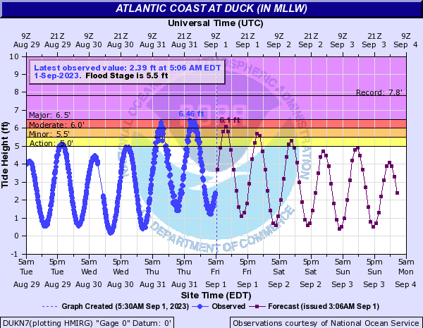
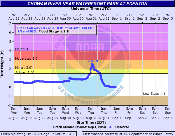
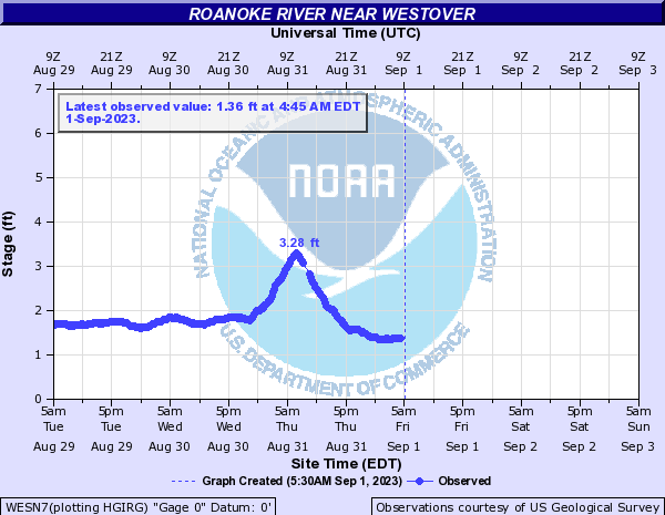
Idalia strengthened to a tropical storm about 150 miles SE of Cancun, Mexico on Sunday, August 27th. Idalia then tracked almost due north for 2.5 days and strengthened to a major hurricane Tuesday night/early Wed AM (8/29-30). Idalia made landfall as a Category 3 hurricane by Keaton Beach, FL during the morning of August 30. At the same time, a moderately strong late summer cold front was approaching the region from the north while ~1020mb high pressure built over the Great Lakes. The front crossed the region during the evening of 8/30 to the early morning on 8/31. Tropical Storm Idalia began to interact with the front as it moved off of the northeast South Carolina coast early on 8/31/2023, then continued to track east-northeast through the day. Sustained Tropical Storm winds were observed along the immediate Currituck County coastline, with tropical storm wind gusts reported into Hampton Roads. A peak wind gust of 52 kt was reported from the Third Island Station in the Lower Chesapeake Bay. This station is 52 ft high. In addition, water levels at 2-2.5 MHHW caused some minor beach and dune erosion from Cape Henry south, with some minor coastal flooding in southside Hampton Roads. In addition, water levels in Edenton, NC (on the north side of the Albemarle Sound) rose to nearly 0.6 ft above minor flood thresholds as the northeast wind pushed water toward the western side of the sound. Also, water levels in Westover, NC (Bertie County) rose to 3.28 ft above NAVD88 (although this is below flood stage according to NC FIMAN). See "Tidal Flooding" section for detailed hydrographs from the event. Appreciable rain amounts were confined to far SE VA and NE NC, where 1 to locally 4 inches of rain fell. Flooding issues were minor as rain rates were not that high and antecedent conditions were dry in the areas that received the most rain.
Tidal Flooding
Selected Hydrographs
 |
 |
 |
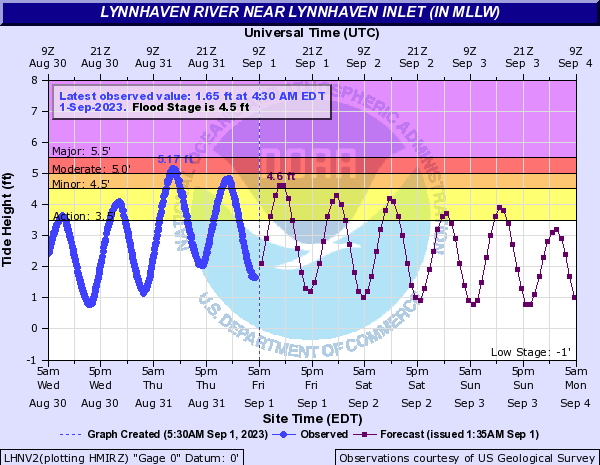 |
| Duck, NC (Eastern Currituck County) | Edenton, NC (Southern Chowan County) | Westover, NC (SE Bertie County) | Lynnhaven, VA (VA Beach on the Chesapeake Bay) |
Photos
Coming Soon
| Caption (source) |
Caption (source) |
Caption (source) |
Caption (source) |
Radar/Satellite
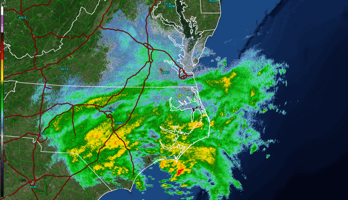
Selected Loops
 |
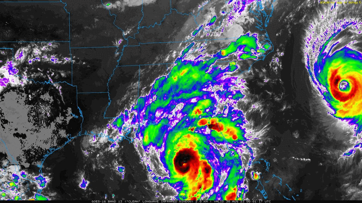 |
| Loop of 0.5° Reflectivity from 11:30 PM on 8/30 to 1:30 PM on 8/31 in ~30 minute increments | Loop of IR Satellite from the 8/29 at 8 PM EDT to 8/31 at 7 PM EDT in 1 hour increments |
Rain/Wind Reports
Public Information Statement
National Weather Service Wakefield VA
622 PM EDT Thu Aug 31 2023

...PRECIPITATION REPORTS...

Location                     Amount    Time/Date       Lat/Lon
Edenton 4.3 SE               3.55 in   0700 AM 08/31   36.01N/76.55W
Edenton 7.4 ESE              2.74 in   1100 AM 08/31   36.02N/76.48W
Hertford                     2.49 in   0530 PM 08/31   36.11N/76.43W
Edenton                      2.24 in   0530 PM 08/31   36.02N/76.57W
Edenton 1.0 NNW              2.05 in   0700 AM 08/31   36.07N/76.61W
Hertford                     2.04 in   0530 PM 08/31   36.16N/76.32W
Elizabeth City 12.1 SE       1.95 in   1200 PM 08/31   36.17N/76.07W
Edenton 0.5 NE               1.95 in   0800 AM 08/31   36.06N/76.60W
Point Harbor 0.2 WSW         1.89 in   0700 AM 08/31   36.08N/75.80W
Elizabeth City               1.78 in   0513 PM 08/31   36.35N/76.28W
Windsor 1.5 ESE              1.76 in   1241 PM 08/31   35.99N/76.92W
Hertford 5.2 SSE             1.72 in   0700 AM 08/31   36.12N/76.43W
Hertford 6.0 SSE             1.70 in   0700 AM 08/31   36.11N/76.42W
Hertford 4.2 N               1.62 in   0700 AM 08/31   36.24N/76.48W
Virginia Beach 6.0 WNW       1.58 in   0700 AM 08/31   36.78N/76.14W
Elizabeth City 7.7 SSW       1.53 in   0700 AM 08/31   36.19N/76.25W
3 SSE Northwest              1.52 in   0530 PM 08/31   36.52N/76.18W
Elizabeth City Airport       1.51 in   0454 PM 08/31   36.27N/76.18W
1 NNE Rockyhock              1.51 in   0530 PM 08/31   36.20N/76.69W
3.1 E Windsor                1.48 in   0517 PM 08/31   36.02N/76.89W
Elizabeth City 1.0 W         1.46 in   0900 AM 08/31   36.30N/76.24W
Elizabeth City 0.8 NW        1.38 in   0800 AM 08/31   36.30N/76.23W
Grandy 0.6 E                 1.35 in   0600 AM 08/31   36.24N/75.87W
Elizabeth City 1.8 SE        1.31 in   0800 AM 08/31   36.28N/76.19W
Elizabeth City 5.1 SSE       1.27 in   0700 AM 08/31   36.22N/76.20W
Tyner 3.1 NNW                1.27 in   0700 AM 08/31   36.28N/76.62W
Moyock 0.7 N                 1.25 in   0929 AM 08/31   36.53N/76.18W
Elizabeth City 2.6 W         1.21 in   0700 AM 08/31   36.30N/76.27W
Edenton 13.3 NNW             1.20 in   0800 AM 08/31   36.23N/76.70W
South Mills                  1.19 in   0430 PM 08/31   36.44N/76.33W
Edenton 10.6 NNW             1.18 in   0800 AM 08/31   36.19N/76.70W
Hertford 0.3 S               1.06 in   0800 AM 08/31   36.18N/76.47W
Currituck                    1.05 in   0525 PM 08/31   36.40N/76.02W
Chesapeake 7.3 NE            1.00 in   0800 AM 08/31   36.75N/76.21W
Gatesville 3.7 ENE           1.00 in   0800 AM 08/31   36.44N/76.70W
---------------------------------------------------------------------

Public Information Statement
National Weather Service Wakefield VA
608 PM EDT Thu Aug 31 2023

...HIGHEST WIND REPORTS...

Location                     Speed     Time/Date       Lat/Lon
Third Island                 60 MPH    0752 AM 08/31   37.04N/76.08W
Chesapeake Light Tower       53 MPH    0845 AM 08/31   36.90N/75.71W
Cape Henry                   50 MPH    0835 AM 08/31   36.93N/76.01W
Cape Henry, VA               50 MPH    0830 AM 08/31   36.93N/76.01W
3.0 E Knotts Island (WEATHER 47 MPH    0750 AM 08/31   36.52N/75.87W
Sandbridge                   47 MPH    0831 AM 08/31   36.70N/75.93W
6 NW Cape Henry              47 MPH    0836 AM 08/31   37.00N/76.09W
Lynnhaven Inlet Light 2      46 MPH    0736 AM 08/31   36.92N/76.09W
Norfolk Intl Airport         45 MPH    0818 AM 08/31   36.90N/76.20W
Poquoson River Light         45 MPH    0711 AM 08/31   37.16N/76.38W
Rudee Inlet                  45 MPH    0644 AM 08/31   36.83N/75.97W
New Point Comfort            44 MPH    0611 AM 08/31   37.33N/76.27W
Oceana NAS Souce             44 MPH    0754 AM 08/31   36.82N/76.02W
Rappahannock Light           44 MPH    0724 AM 08/31   37.54N/76.02W
Elizabeth City Airport       43 MPH    0726 AM 08/31   36.27N/76.18W
Willoughby Deguassing Statio 43 MPH    0724 AM 08/31   36.98N/76.32W
Middle Ground Lighthouse     43 MPH    0757 AM 08/31   36.95N/76.39W
5 NE Plum Tree Island Refuge 43 MPH    0806 AM 08/31   37.20N/76.27W
Thimble Shoals               42 MPH    0825 AM 08/31   37.05N/76.26W
South Norfolk Jordan Bridge  41 MPH    0654 AM 08/31   36.81N/76.29W
Norfolk NAS Cham             41 MPH    0651 AM 08/31   36.92N/76.27W
8 NW Cape Henry              41 MPH    0800 AM 08/31   37.03N/76.08W
Poquoson                     40 MPH    0817 AM 08/31   37.11N/76.32W
Tangier Sound Light          40 MPH    0840 AM 08/31   37.79N/75.97W
2 E Stingray Point           40 MPH    0642 AM 08/31   37.57N/76.26W
Tropical Cyclone History
See the NHC graphics archive for a detailed loop of Idalia's track along with the associated advisories.
 |
| Idalia Wind History (from NHC) |
Environment
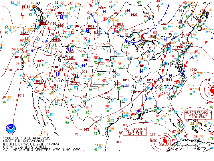
Synoptic summary.
 |
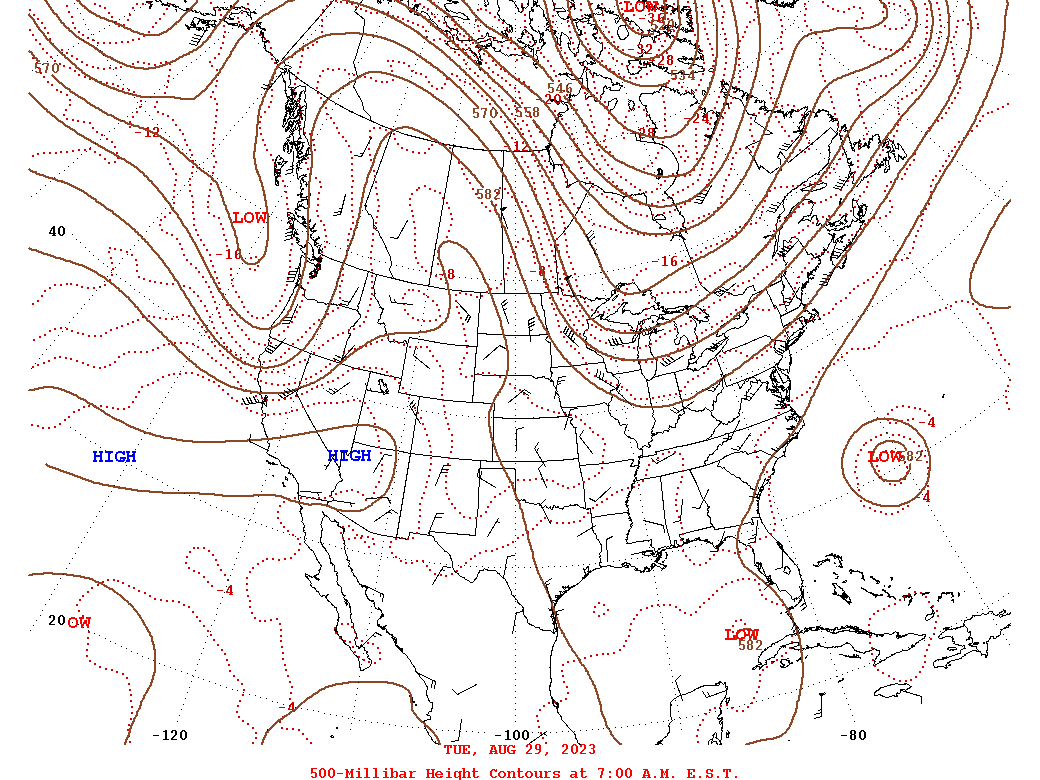 |
| Loop of WPC Surface Analysis from 8/29 at 12z/8 AM EDT to 9/1 at 00z (8/31 at 8 PM EDT) | Loop of WPC 500mb Analysis from 8/29 at 12z/8 AM EDT to 8/31 at 12z/8 AM EDT |
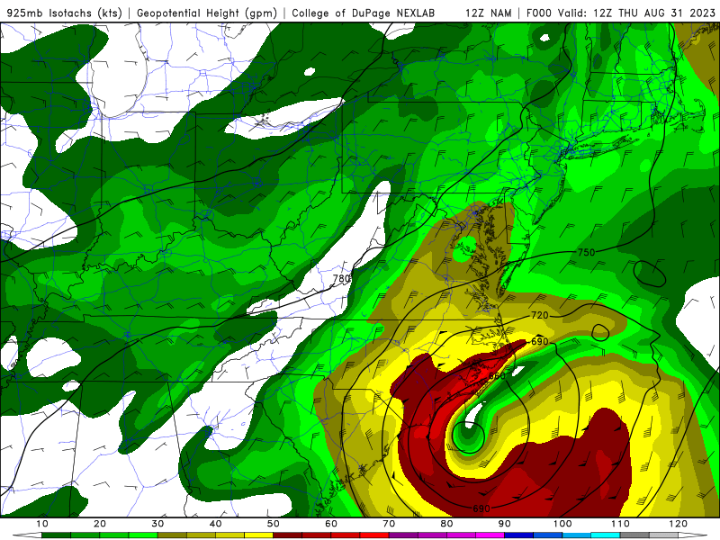
Near-storm 925mb maps
 |
.png) |
| 8/31 12z/8 AM NAM Analysis 925mb Height/Wind | 8/31 12z/8 AM NAM Analysis 925mb Height/Wind |
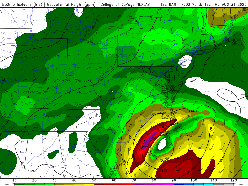
Near-storm 850mb maps
 |
 |
| 8/31 12z/8 AM NAM Analysis 850mb Height/Wind | 8/31 8 AM NAM Analysis 850mb Height/Wind |
 |
Media use of NWS Web News Stories is encouraged! Please acknowledge the NWS as the source of any news information accessed from this site. |
|


 Coastal Flood
 Heat
Heat