Overview
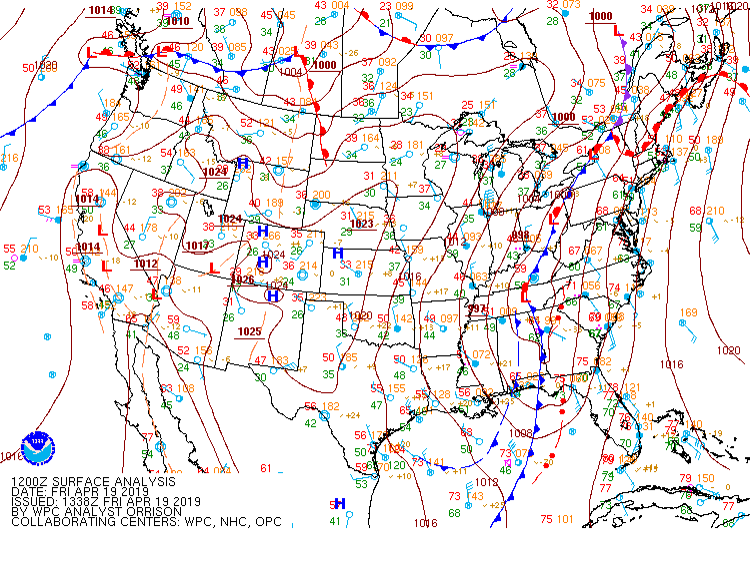
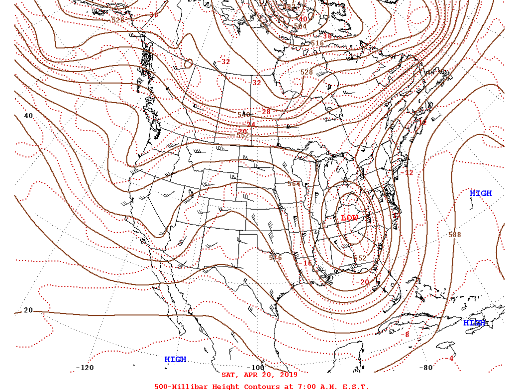
On the morning of April 19th, a deep upper trough was centered over the Mississippi River Valley, with the associated area of low pressure at the surface centered just west of the Appalachians. Much of the eastern United States was in the warm sector, and showers and thunderstorms (some severe) were ongoing from South Carolina to northern Florida. Winds were SE-SSE over much of the Mid-Atlantic region, with 850-500 mb winds largely out of the SSW-SW as the upper trough was slowly moving to the ENE. Temperatures warmed into the 70s throughout the area by early afternoon before an area of rain (with a few embedded severe t-storms) quickly moved across the CWA from south to north. After the area of rain exited the CWA, temperatures rebounded back into the low-mid 70s from central VA to northern NC by late afternoon-early evening (with dew points in the mid-upper 60s). This allowed for modest surface-based instability to develop over the area (SBCAPE/MLCAPE values of 500-1000 J/kg on average) while LCLs remained low due to the relatively small T/Td spread. At the same time, a line of thunderstorms with embedded supercells rapidly tracked to the NE across NC towards our CWA.
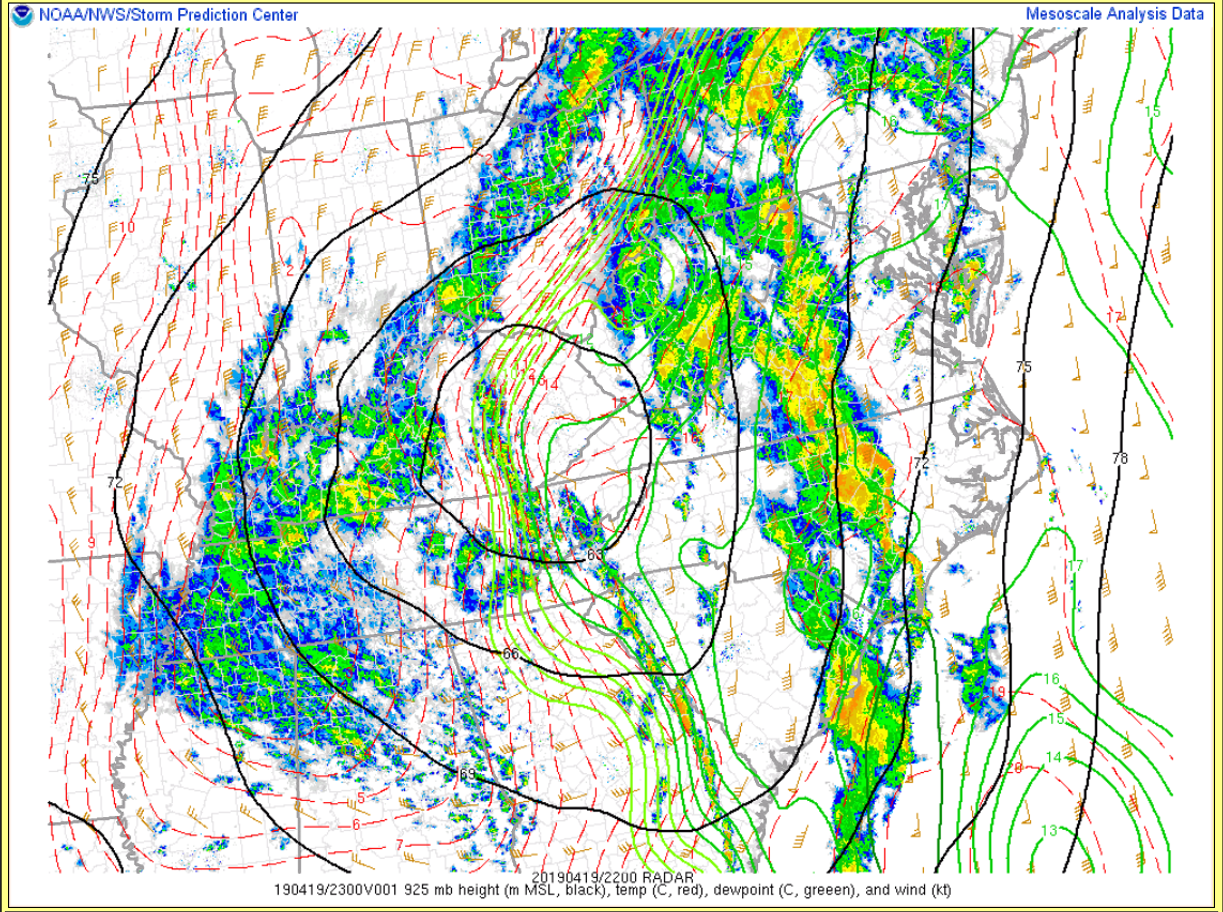
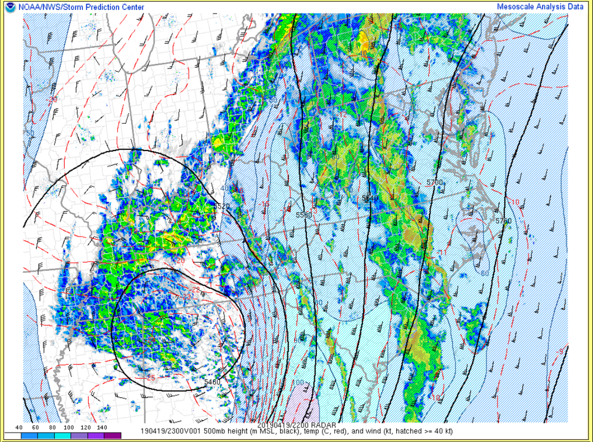
As the line entered our area from the SW during the early evening, winds were still out of the SSE as the strong (~992 mb) surface low was centered over the Appalachians (directly to our west). Winds veered to the S then SSW from 925-850 mb, with 45-60 kt winds just 1-2 km above the surface. This rapid increase in winds from the surface to the 925-850 mb layer (combined with veering of the winds from the surface-850 mb) resulted in 0-1 km SRH values of 300-400 m2/s2 over much of the area. As the aforementioned upper trough moved eastward (and a closed upper low formed over TN/AL by evening), mid-level winds increased to nearly 70 kt over the area (but wind profiles remained largely unidirectional from 850-500 mb). See the Environment section for more details (and a few RAP analysis soundings from selected locations) from 6-9 PM on the evening of the 19th. The combination of modest surface-based instability, 300-400 m2/s2 of 0-1 km SRH, and low LCLs allowed for several tornadoes to touch down from the VA Piedmont to central/SE VA to interior NE NC as the line quickly moved across the area from SW to NE. With strong mean-layer winds, the storms moved as fast as 70 mph at times! All of the tornadoes over our CWA occurred from 6:30-8:30 PM. As the line approached the Lower Eastern Shore during the late evening hours, a stable marine layer in place (especially near the Atlantic coast) likely played a part in preventing any additional tornado development. In addition, this stable marine layer likely contributed to the weakening of the line as it approached the Atlantic coast. While the main line of t-storms exited the area by 10 PM, more showers (w/ embedded t-storms) continued through the overnight hours across SE VA/NE NC before the trailing cold front crossed the area from SW to NE on the morning of the 20th (as the area of low pressure began occluding). There were a few reports of street flooding across far SE VA/NE NC. In total, *14* tornadoes were confirmed across the area on the 19th, making this the day with the highest number of tornadoes over our CWA since February 24, 2016.
See the Radar section for close-up images (including dual-pol variables) of several of the embedded supercells that produced tornadoes. There were even a few tornado debris signatures that were observed, and a couple of these are shown as well.
***Please note that this data is preliminary and is subject to change***
Tornadoes:
|
Tornado - Western Northampton County, NC
Track Map  
|
||||||||||||||||
|
Tornado - Garysburg, NC to East Emporia, VA
Track Map 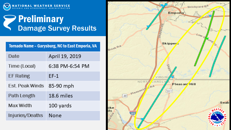
|
||||||||||||||||
|
Tornado - SE Greensville County, VA
Track Map 
|
||||||||||||||||
|
Tornado - Near Brodnax, VA
Track Map 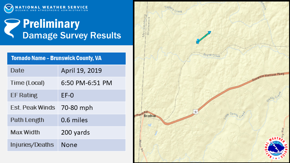
|
||||||||||||||||
|
Tornado - Jackson to Margarettsville, NC
Track Map 
|
||||||||||||||||
|
Tornado - Emporia, VA
Track Map 
|
||||||||||||||||
|
Tornado - Sussex, VA
Track Map 
|
||||||||||||||||
|
Tornado - Disputanta, VA
Track Map 
|
||||||||||||||||
|
Tornado - Charles City, VA
Track Map  |
||||||||||||||||
|
Tornado - NW of Smithfield, VA
Track Map 
|
||||||||||||||||
|
Tornado - Williamsburg, VA
Track Map  |
||||||||||||||||
|
Tornado - East of Mineral, VA
Track Map 
|
||||||||||||||||
|
Tornado - Newport News, VA
Track Map  |
||||||||||||||||
|
Tornado - Mill Creek to Maryus, VA
Track Map  |
||||||||||||||||
The Enhanced Fujita (EF) Scale classifies tornadoes into the following categories:
| EF0 Weak 65-85 mph |
EF1 Moderate 86-110 mph |
EF2 Significant 111-135 mph |
EF3 Severe 136-165 mph |
EF4 Extreme 166-200 mph |
EF5 Catastrophic 200+ mph |
 |
|||||
Photos
Selected NWS Storm Survey Photos
 |
 |
 |
 |
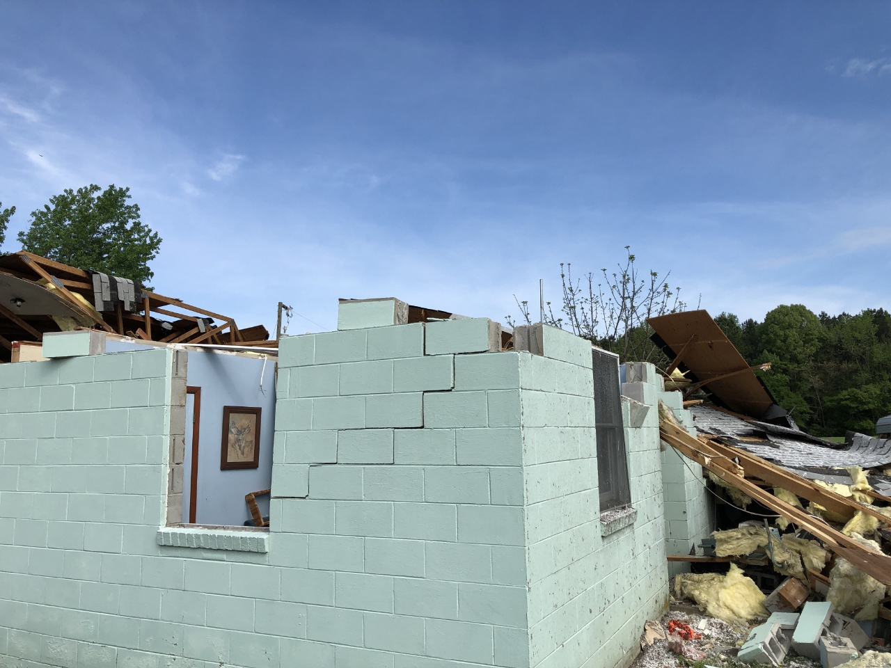
| Damage in Charles City | Damage in Charles City | Damage in Charles City | Damage in Charles City |
 |
 |
 |
 |
| Damage in Disputanta | Damage in Disputanta | Damage in Disputanta | Damage in Disputanta |
 |
 |
 |
 |
| Damage in Williamsburg | Damage in Williamsburg | Damage in Gloucester County | Damage in Gloucester County |
Radar
Selected Radar Images
 |
 |
 |
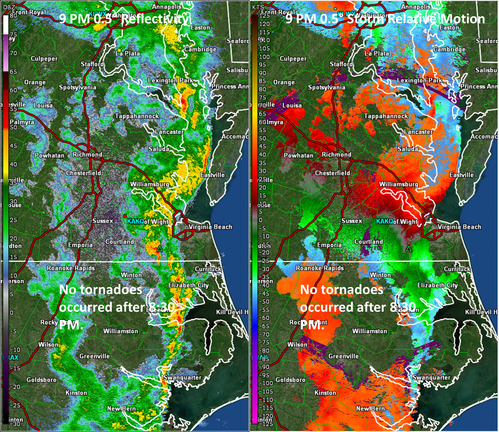 |
| 6 PM 0.5° Reflectivity/SRM | 7 PM 0.5° Reflectivity/SRM...Note that 5 tornadoes occurred in our CWA from 6:30 to 6:55 PM. | 8 PM 0.5° Reflectivity/SRM...This was around the time of the Louisa/Charles City EF-2 tornadoes. | 9 PM 0.5° Refectivity/SRM |
 |
 |
 |
 |
| Radar Image Showing the Tornado Debris Signature from Brunswick County. | 650 PM...3 tornadoes on ground from Greensville County, VA to Northampton County, NC. | 748 PM...Tornado Debris Signature near Charles City. | 800 PM...Tornado about to form in Louisa County. |
Storm Reports
046
NWUS51 KAKQ 231626
LSRAKQ

PRELIMINARY LOCAL STORM REPORT
NATIONAL WEATHER SERVICE WAKEFIELD VA
1226 PM EDT TUE APR 23 2019

..TIME...   ...EVENT...      ...CITY LOCATION...     ...LAT.LON...
..DATE...   ....MAG....      ..COUNTY LOCATION..ST.. ...SOURCE....
            ..REMARKS..

0610 PM     TSTM WND DMG     1 WNW FARMVILLE         37.30N 78.41W
04/19/2019                   PRINCE EDWARD      VA   TRAINED SPOTTER

            3 TREES UPROOTED AND SOME SNAPPED NEAR THE
            CENTRAL VA REGIONAL LIBRARY.


&&

$$

JO
895
NWUS51 KAKQ 231425
LSRAKQ

PRELIMINARY LOCAL STORM REPORT
NATIONAL WEATHER SERVICE WAKEFIELD VA
1025 AM EDT TUE APR 23 2019

..TIME...   ...EVENT...      ...CITY LOCATION...     ...LAT.LON...
..DATE...   ....MAG....      ..COUNTY LOCATION..ST.. ...SOURCE....
            ..REMARKS..

0915 PM     TSTM WND DMG     5 NE SHARON             36.54N 76.24W
04/19/2019                   CURRITUCK          NC   EMERGENCY MNGR

            TREE DOWN ON MOBILE HOME. TIME ESTIMATED
            FROM RADAR.


&&

$$

EI
043
NWUS51 KAKQ 231240
LSRAKQ

PRELIMINARY LOCAL STORM REPORT
NATIONAL WEATHER SERVICE WAKEFIELD VA
840 AM EDT TUE APR 23 2019

..TIME...   ...EVENT...      ...CITY LOCATION...     ...LAT.LON...
..DATE...   ....MAG....      ..COUNTY LOCATION..ST.. ...SOURCE....
            ..REMARKS..

0748 PM     TORNADO          1 E RUTHVILLE           37.37N 77.03W
04/19/2019                   CHARLES CITY       VA   NWS STORM SURVEY

            NWS STORM SURVEY CONFIRMED AN EF2 TORNADO IN
            CHARLES CITY COUNTY, VA NEAR RUTHVILLE.


&&

$$
009
NWUS51 KAKQ 221912
LSRAKQ

PRELIMINARY LOCAL STORM REPORT
NATIONAL WEATHER SERVICE WAKEFIELD VA
312 PM EDT MON APR 22 2019

..TIME...   ...EVENT...      ...CITY LOCATION...     ...LAT.LON...
..DATE...   ....MAG....      ..COUNTY LOCATION..ST.. ...SOURCE....
            ..REMARKS..

0910 PM     TSTM WND DMG     2 WNW DEEP CREEK        36.75N 76.38W
04/19/2019                   CITY OF CHESAPEAKE VA   PUBLIC

            TREES SNAPPED ON MARTIN JOHNSON ROAD.


&&

$$
310
NWUS51 KAKQ 221624
LSRAKQ

PRELIMINARY LOCAL STORM REPORT
NATIONAL WEATHER SERVICE WAKEFIELD VA
1224 PM EDT MON APR 22 2019

..TIME...   ...EVENT...      ...CITY LOCATION...     ...LAT.LON...
..DATE...   ....MAG....      ..COUNTY LOCATION..ST.. ...SOURCE....
            ..REMARKS..

0807 PM     TORNADO          1 SSW DENBIGH           37.11N 76.54W
04/19/2019                   CITY OF NEWPORT NEWVA   NWS STORM SURVEY

            NWS STORM SURVEY CONFIRMED AN EF0 TORNADO IN
            THE DENBIGH SECTION OF THE CITY OF NEWPORT
            NEWS, VA.


&&

$$
703
NWUS51 KAKQ 221621
LSRAKQ

PRELIMINARY LOCAL STORM REPORT
NATIONAL WEATHER SERVICE WAKEFIELD VA
1221 PM EDT MON APR 22 2019

..TIME...   ...EVENT...      ...CITY LOCATION...     ...LAT.LON...
..DATE...   ....MAG....      ..COUNTY LOCATION..ST.. ...SOURCE....
            ..REMARKS..

0806 PM     TORNADO          QUEENS LAKE             37.29N 76.66W
04/19/2019                   YORK               VA   NWS STORM SURVEY

            NWS STORM SURVEY CONFIRMED AN EF0 TORNADO IN
            THE QUEENS LAKE SECTION OF YORK COUNTY, VA.


&&

$$
122
NWUS51 KAKQ 221618
LSRAKQ

PRELIMINARY LOCAL STORM REPORT
NATIONAL WEATHER SERVICE WAKEFIELD VA
1218 PM EDT MON APR 22 2019

..TIME...   ...EVENT...      ...CITY LOCATION...     ...LAT.LON...
..DATE...   ....MAG....      ..COUNTY LOCATION..ST.. ...SOURCE....
            ..REMARKS..

0820 PM     TORNADO          1 SSW MARYUS            37.27N 76.41W
04/19/2019                   GLOUCESTER         VA   NWS STORM SURVEY

            NWS STORM SURVEY CONFIRMED AN EF0 TORNADO
            NEAR MARYUS IN GLOUCESTER COUNTY, VA.


&&

$$
622
NWUS51 KAKQ 211230
LSRAKQ

PRELIMINARY LOCAL STORM REPORT
NATIONAL WEATHER SERVICE WAKEFIELD VA
830 AM EDT SUN APR 21 2019

..TIME...   ...EVENT...      ...CITY LOCATION...     ...LAT.LON...
..DATE...   ....MAG....      ..COUNTY LOCATION..ST.. ...SOURCE....
            ..REMARKS..

0105 AM     TSTM WND DMG     APPLE GROVE             37.90N 77.90W
04/15/2019                   LOUISA             VA   NWS EMPLOYEE

            SEVERAL TREES WERE DOWN ACROSS US 522
            IMMEDIATELY NORTH OF APPLE GROVE. THE TREES
            WERE RECENTLY CLEARED, AND THE DIRECTION
            THEY WERE LAYING WAS MORE CONSISTENT WITH
            THE APRIL 15 EVENT. TIME ESTIMATED FROM
            RADAR.


&&

$$

AJZ
162
NWUS51 KAKQ 202140
LSRAKQ

PRELIMINARY LOCAL STORM REPORT
NATIONAL WEATHER SERVICE WAKEFIELD VA
540 PM EDT SAT APR 20 2019

..TIME...   ...EVENT...      ...CITY LOCATION...     ...LAT.LON...
..DATE...   ....MAG....      ..COUNTY LOCATION..ST.. ...SOURCE....
            ..REMARKS..

0756 PM     TORNADO          2 WNW LAWSON            37.03N 76.66W
04/19/2019                   ISLE OF WIGHT      VA   NWS STORM SURVEY


&&

$$

JO
553
NWUS51 KAKQ 202133
LSRAKQ

PRELIMINARY LOCAL STORM REPORT
NATIONAL WEATHER SERVICE WAKEFIELD VA
533 PM EDT SAT APR 20 2019

..TIME...   ...EVENT...      ...CITY LOCATION...     ...LAT.LON...
..DATE...   ....MAG....      ..COUNTY LOCATION..ST.. ...SOURCE....
            ..REMARKS..

0935 PM     TSTM WND DMG     2 SSE LINKWOOD          38.52N 75.93W
04/19/2019                   DORCHESTER         MD   EMERGENCY MNGR

            TREES DOWN.


&&

$$

JO
901
NWUS51 KAKQ 202129
LSRAKQ

PRELIMINARY LOCAL STORM REPORT
NATIONAL WEATHER SERVICE WAKEFIELD VA
529 PM EDT SAT APR 20 2019

..TIME...   ...EVENT...      ...CITY LOCATION...     ...LAT.LON...
..DATE...   ....MAG....      ..COUNTY LOCATION..ST.. ...SOURCE....
            ..REMARKS..

0807 PM     TORNADO          2 N FREDERICKS HALL     38.01N 77.82W
04/19/2019                   LOUISA             VA   NWS STORM SURVEY


&&

$$

JO
555
NWUS51 KAKQ 202126
LSRAKQ

PRELIMINARY LOCAL STORM REPORT
NATIONAL WEATHER SERVICE WAKEFIELD VA
526 PM EDT SAT APR 20 2019

..TIME...   ...EVENT...      ...CITY LOCATION...     ...LAT.LON...
..DATE...   ....MAG....      ..COUNTY LOCATION..ST.. ...SOURCE....
            ..REMARKS..

0737 PM     TORNADO          3 NNW BARHAM            37.18N 77.13W
04/19/2019                   PRINCE GEORGE      VA   NWS STORM SURVEY


&&

$$

JO
894
NWUS51 KAKQ 202125
LSRAKQ

PRELIMINARY LOCAL STORM REPORT
NATIONAL WEATHER SERVICE WAKEFIELD VA
525 PM EDT SAT APR 20 2019

..TIME...   ...EVENT...      ...CITY LOCATION...     ...LAT.LON...
..DATE...   ....MAG....      ..COUNTY LOCATION..ST.. ...SOURCE....
            ..REMARKS..

0733 PM     TORNADO          4 SE DISPUTANTA         37.09N 77.17W
04/19/2019                   SUSSEX             VA   NWS STORM SURVEY


&&

$$

JO
206
NWUS51 KAKQ 202123
LSRAKQ

PRELIMINARY LOCAL STORM REPORT
NATIONAL WEATHER SERVICE WAKEFIELD VA
523 PM EDT SAT APR 20 2019

..TIME...   ...EVENT...      ...CITY LOCATION...     ...LAT.LON...
..DATE...   ....MAG....      ..COUNTY LOCATION..ST.. ...SOURCE....
            ..REMARKS..

0725 PM     TORNADO          3 NNE BOOKER            36.98N 77.27W
04/19/2019                   SUSSEX             VA   NWS STORM SURVEY


&&

$$

JO
106
NWUS51 KAKQ 202122
LSRAKQ

PRELIMINARY LOCAL STORM REPORT
NATIONAL WEATHER SERVICE WAKEFIELD VA
522 PM EDT SAT APR 20 2019

..TIME...   ...EVENT...      ...CITY LOCATION...     ...LAT.LON...
..DATE...   ....MAG....      ..COUNTY LOCATION..ST.. ...SOURCE....
            ..REMARKS..

0718 PM     TSTM WND DMG     3 ESE SEBRELL           36.77N 77.08W
04/19/2019                   SOUTHAMPTON        VA   NWS STORM SURVEY

            TREES DOWN.


&&

$$

JO
368
NWUS51 KAKQ 202120
LSRAKQ

PRELIMINARY LOCAL STORM REPORT
NATIONAL WEATHER SERVICE WAKEFIELD VA
520 PM EDT SAT APR 20 2019

..TIME...   ...EVENT...      ...CITY LOCATION...     ...LAT.LON...
..DATE...   ....MAG....      ..COUNTY LOCATION..ST.. ...SOURCE....
            ..REMARKS..

0655 PM     TORNADO          1 ENE EMPORIA RESERVOIR 36.71N 77.55W
04/19/2019                   CITY OF EMPORIA    VA   NWS STORM SURVEY


&&

$$

JO
853
NWUS51 KAKQ 202114
LSRAKQ

PRELIMINARY LOCAL STORM REPORT
NATIONAL WEATHER SERVICE WAKEFIELD VA
514 PM EDT SAT APR 20 2019

..TIME...   ...EVENT...      ...CITY LOCATION...     ...LAT.LON...
..DATE...   ....MAG....      ..COUNTY LOCATION..ST.. ...SOURCE....
            ..REMARKS..

0655 PM     TORNADO          3 SSW EMPORIA RESERVOIR 36.66N 77.58W
04/19/2019                   GREENSVILLE        VA   NWS STORM SURVEY


&&

$$

JO
527
NWUS51 KAKQ 202112
LSRAKQ

PRELIMINARY LOCAL STORM REPORT
NATIONAL WEATHER SERVICE WAKEFIELD VA
512 PM EDT SAT APR 20 2019

..TIME...   ...EVENT...      ...CITY LOCATION...     ...LAT.LON...
..DATE...   ....MAG....      ..COUNTY LOCATION..ST.. ...SOURCE....
            ..REMARKS..

0654 PM     TORNADO          2 E SEABOARD            36.48N 77.40W
04/19/2019                   NORTHAMPTON        NC   NWS STORM SURVEY


&&

$$

JO
270
NWUS51 KAKQ 202109
LSRAKQ

PRELIMINARY LOCAL STORM REPORT
NATIONAL WEATHER SERVICE WAKEFIELD VA
509 PM EDT SAT APR 20 2019

..TIME...   ...EVENT...      ...CITY LOCATION...     ...LAT.LON...
..DATE...   ....MAG....      ..COUNTY LOCATION..ST.. ...SOURCE....
            ..REMARKS..

0652 PM     TORNADO          1 SE CLARESVILLE        36.61N 77.44W
04/19/2019                   GREENSVILLE        VA   NWS STORM SURVEY


&&

$$

JO
515
NWUS51 KAKQ 202108
LSRAKQ

PRELIMINARY LOCAL STORM REPORT
NATIONAL WEATHER SERVICE WAKEFIELD VA
508 PM EDT SAT APR 20 2019

..TIME...   ...EVENT...      ...CITY LOCATION...     ...LAT.LON...
..DATE...   ....MAG....      ..COUNTY LOCATION..ST.. ...SOURCE....
            ..REMARKS..

0650 PM     TORNADO          1 NW CLARESVILLE        36.63N 77.46W
04/19/2019                   GREENSVILLE        VA   NWS STORM SURVEY


&&

$$

JO
184
NWUS51 KAKQ 202105
LSRAKQ

PRELIMINARY LOCAL STORM REPORT
NATIONAL WEATHER SERVICE WAKEFIELD VA
505 PM EDT SAT APR 20 2019

..TIME...   ...EVENT...      ...CITY LOCATION...     ...LAT.LON...
..DATE...   ....MAG....      ..COUNTY LOCATION..ST.. ...SOURCE....
            ..REMARKS..

0640 PM     TORNADO          2 WNW GARYSBURG         36.46N 77.59W
04/19/2019                   NORTHAMPTON        NC   PUBLIC


&&

$$

JO
617
NWUS51 KAKQ 202105
LSRAKQ

PRELIMINARY LOCAL STORM REPORT
NATIONAL WEATHER SERVICE WAKEFIELD VA
505 PM EDT SAT APR 20 2019

..TIME...   ...EVENT...      ...CITY LOCATION...     ...LAT.LON...
..DATE...   ....MAG....      ..COUNTY LOCATION..ST.. ...SOURCE....
            ..REMARKS..

0648 PM     TORNADO          1 SSE DAHLIA            36.55N 77.53W
04/19/2019                   GREENSVILLE        VA   PUBLIC


&&

$$

JO
284
NWUS51 KAKQ 202104
LSRAKQ

PRELIMINARY LOCAL STORM REPORT
NATIONAL WEATHER SERVICE WAKEFIELD VA
504 PM EDT SAT APR 20 2019

..TIME...   ...EVENT...      ...CITY LOCATION...     ...LAT.LON...
..DATE...   ....MAG....      ..COUNTY LOCATION..ST.. ...SOURCE....
            ..REMARKS..

0632 PM     TORNADO          2 WNW GUM FORKS         36.51N 77.72W
04/19/2019                   NORTHAMPTON        NC   NWS STORM SURVEY


&&

$$

JO
690
NWUS51 KAKQ 201147
LSRAKQ

PRELIMINARY LOCAL STORM REPORT
NATIONAL WEATHER SERVICE WAKEFIELD VA
747 AM EDT SAT APR 20 2019

..TIME...   ...EVENT...      ...CITY LOCATION...     ...LAT.LON...
..DATE...   ....MAG....      ..COUNTY LOCATION..ST.. ...SOURCE....
            ..REMARKS..

0805 PM     TSTM WND DMG     QUEENS LAKE             37.29N 76.66W
04/19/2019                   YORK               VA   EMERGENCY MNGR

            NUMEROUS TREES DOWN QUEENS LAKE COMMUNITY.


&&

$$

JO
304
NWUS51 KAKQ 201132
LSRAKQ

PRELIMINARY LOCAL STORM REPORT
NATIONAL WEATHER SERVICE WAKEFIELD VA
732 AM EDT SAT APR 20 2019

..TIME...   ...EVENT...      ...CITY LOCATION...     ...LAT.LON...
..DATE...   ....MAG....      ..COUNTY LOCATION..ST.. ...SOURCE....
            ..REMARKS..

0944 PM     TSTM WND GST     1 SE SALISBURY-WICOMICO 38.33N 75.50W
04/19/2019  M46 MPH          WICOMICO           MD   ASOS

            ASOS STATION KSBY SALISBURY WICOMICO
            AIRPORT.


&&

$$

JO
110
NWUS51 KAKQ 201132
LSRAKQ

PRELIMINARY LOCAL STORM REPORT
NATIONAL WEATHER SERVICE WAKEFIELD VA
732 AM EDT SAT APR 20 2019

..TIME...   ...EVENT...      ...CITY LOCATION...     ...LAT.LON...
..DATE...   ....MAG....      ..COUNTY LOCATION..ST.. ...SOURCE....
            ..REMARKS..

0352 PM     TSTM WND GST     NORFOLK INTERNATIONAL A 36.90N 76.20W
04/19/2019  M46 MPH          CITY OF NORFOLK    VA   ASOS

            ASOS STATION KORF NORFOLK INTL AIRPORT.


&&

$$

JO
459
NWUS51 KAKQ 201132
LSRAKQ

PRELIMINARY LOCAL STORM REPORT
NATIONAL WEATHER SERVICE WAKEFIELD VA
732 AM EDT SAT APR 20 2019

..TIME...   ...EVENT...      ...CITY LOCATION...     ...LAT.LON...
..DATE...   ....MAG....      ..COUNTY LOCATION..ST.. ...SOURCE....
            ..REMARKS..

0852 PM     MARINE TSTM WIND 1 NNW SILVER BEACH      37.49N 75.97W
04/19/2019  M45 MPH          ANZ631             VA   MESONET

            MESONET STATION XSIL SILVER BEACH.


&&

$$

JO
849
NWUS51 KAKQ 201130
LSRAKQ

PRELIMINARY LOCAL STORM REPORT
NATIONAL WEATHER SERVICE WAKEFIELD VA
730 AM EDT SAT APR 20 2019

..TIME...   ...EVENT...      ...CITY LOCATION...     ...LAT.LON...
..DATE...   ....MAG....      ..COUNTY LOCATION..ST.. ...SOURCE....
            ..REMARKS..

0909 PM     MARINE TSTM WIND 2 WSW HARBORTON         37.65N 75.88W
04/19/2019  M48 MPH          ACCOMACK           VA   MESONET

            MESONET STATION XHAK ONANCOCK.


&&

$$

JO
386
NWUS51 KAKQ 201130
LSRAKQ

PRELIMINARY LOCAL STORM REPORT
NATIONAL WEATHER SERVICE WAKEFIELD VA
730 AM EDT SAT APR 20 2019

..TIME...   ...EVENT...      ...CITY LOCATION...     ...LAT.LON...
..DATE...   ....MAG....      ..COUNTY LOCATION..ST.. ...SOURCE....
            ..REMARKS..

0943 PM     TSTM WND GST     1 E OCEANA NAS          36.82N 76.02W
04/19/2019  M47 MPH          CITY OF VIRGINIA BEVA   AWOS

            AWOS STATION KNTU OCEANA NAS SOUCE.


&&

$$

JO
158
NWUS51 KAKQ 201130
LSRAKQ

PRELIMINARY LOCAL STORM REPORT
NATIONAL WEATHER SERVICE WAKEFIELD VA
730 AM EDT SAT APR 20 2019

..TIME...   ...EVENT...      ...CITY LOCATION...     ...LAT.LON...
..DATE...   ....MAG....      ..COUNTY LOCATION..ST.. ...SOURCE....
            ..REMARKS..

0830 PM     MARINE TSTM WIND 4 ESE MARYUS            37.25N 76.33W
04/19/2019  M46 MPH          ANZ632             VA   MESONET

            MESONET STATION YKRV2 YORK RIVER EAST REAR
            RANGE LIGHT.


&&

$$

JO
950
NWUS51 KAKQ 201129
LSRAKQ

PRELIMINARY LOCAL STORM REPORT
NATIONAL WEATHER SERVICE WAKEFIELD VA
729 AM EDT SAT APR 20 2019

..TIME...   ...EVENT...      ...CITY LOCATION...     ...LAT.LON...
..DATE...   ....MAG....      ..COUNTY LOCATION..ST.. ...SOURCE....
            ..REMARKS..

0935 PM     TSTM WND GST     CHESAPEAKE AIRPORT      36.67N 76.32W
04/19/2019  M51 MPH          CITY OF CHESAPEAKE VA   AWOS

            AWOS STATION KCPK CHESAPEAKE.


&&

$$

JO
951
NWUS51 KAKQ 201129
LSRAKQ

PRELIMINARY LOCAL STORM REPORT
NATIONAL WEATHER SERVICE WAKEFIELD VA
729 AM EDT SAT APR 20 2019

..TIME...   ...EVENT...      ...CITY LOCATION...     ...LAT.LON...
..DATE...   ....MAG....      ..COUNTY LOCATION..ST.. ...SOURCE....
            ..REMARKS..

0155 PM     TSTM WND GST     2 ESE MESSICK           37.11N 76.32W
04/19/2019  M50 MPH          CITY OF POQUOSON   VA   MESONET

            MESONET STATION XPOQ POQUOSON.


&&

$$

JO
847
NWUS51 KAKQ 201129
LSRAKQ

PRELIMINARY LOCAL STORM REPORT
NATIONAL WEATHER SERVICE WAKEFIELD VA
729 AM EDT SAT APR 20 2019

..TIME...   ...EVENT...      ...CITY LOCATION...     ...LAT.LON...
..DATE...   ....MAG....      ..COUNTY LOCATION..ST.. ...SOURCE....
            ..REMARKS..

0506 PM     MARINE TSTM WIND 1 WSW CAPE CHARLES      37.26N 76.03W
04/19/2019  M49 MPH          ANZ632             VA   MESONET

            MESONET STATION XPLT PLANTATION FLATS.


&&

$$

JO
391
NWUS51 KAKQ 201128
LSRAKQ

PRELIMINARY LOCAL STORM REPORT
NATIONAL WEATHER SERVICE WAKEFIELD VA
728 AM EDT SAT APR 20 2019

..TIME...   ...EVENT...      ...CITY LOCATION...     ...LAT.LON...
..DATE...   ....MAG....      ..COUNTY LOCATION..ST.. ...SOURCE....
            ..REMARKS..

0910 PM     TSTM WND GST     1 NW NORTHAMPTON        37.06N 76.43W
04/19/2019  U60 MPH          CITY OF HAMPTON    VA   PUBLIC

            WIND GUST 60 TO 65 MPH. NUMEROUS TREES
            REPORTED DOWN IN CITY OF HAMPTON.


&&

$$

JO
873
NWUS51 KAKQ 201128
LSRAKQ

PRELIMINARY LOCAL STORM REPORT
NATIONAL WEATHER SERVICE WAKEFIELD VA
728 AM EDT SAT APR 20 2019

..TIME...   ...EVENT...      ...CITY LOCATION...     ...LAT.LON...
..DATE...   ....MAG....      ..COUNTY LOCATION..ST.. ...SOURCE....
            ..REMARKS..

0430 PM     MARINE TSTM WIND 2 SSW FORT MONROE       36.98N 76.32W
04/19/2019  M51 MPH          ANZ638             VA   MESONET

            MESONET STATION WDSV2 WILLOUGHBY DEGUASSING
            STATION.


&&

$$

JO
178
NWUS51 KAKQ 201127
LSRAKQ

PRELIMINARY LOCAL STORM REPORT
NATIONAL WEATHER SERVICE WAKEFIELD VA
727 AM EDT SAT APR 20 2019

..TIME...   ...EVENT...      ...CITY LOCATION...     ...LAT.LON...
..DATE...   ....MAG....      ..COUNTY LOCATION..ST.. ...SOURCE....
            ..REMARKS..

0932 PM     TSTM WND GST     1 S MOUNT PLEASANT      36.70N 76.13W
04/19/2019  M61 MPH          CITY OF CHESAPEAKE VA   AWOS

            AWOS STATION KNFE FENTRESS NAVAL.


&&

$$

JO
851
NWUS51 KAKQ 201127
LSRAKQ

PRELIMINARY LOCAL STORM REPORT
NATIONAL WEATHER SERVICE WAKEFIELD VA
727 AM EDT SAT APR 20 2019

..TIME...   ...EVENT...      ...CITY LOCATION...     ...LAT.LON...
..DATE...   ....MAG....      ..COUNTY LOCATION..ST.. ...SOURCE....
            ..REMARKS..

0811 PM     TSTM WND GST     PATRICK HENRY FIEL      37.13N 76.50W
04/19/2019  M54 MPH          CITY OF NEWPORT NEWVA   ASOS

            ASOS STATION KPHF NEWPORT NEWS.


&&

$$

JO
413
NWUS51 KAKQ 201126
LSRAKQ

PRELIMINARY LOCAL STORM REPORT
NATIONAL WEATHER SERVICE WAKEFIELD VA
726 AM EDT SAT APR 20 2019

..TIME...   ...EVENT...      ...CITY LOCATION...     ...LAT.LON...
..DATE...   ....MAG....      ..COUNTY LOCATION..ST.. ...SOURCE....
            ..REMARKS..

0828 PM     TSTM WND DMG     2 NNW MOLLUSK           37.75N 76.56W
04/19/2019                   LANCASTER          VA   EMERGENCY MNGR

            CORRECTS PREVIOUS TSTM WND DMG REPORT FROM 2
            NNW MOLLUSK. SEVERAL TREES DOWN ACROSS
            WESTER LANCASTER.


&&

$$

JO
691
NWUS51 KAKQ 201121
LSRAKQ

PRELIMINARY LOCAL STORM REPORT
NATIONAL WEATHER SERVICE WAKEFIELD VA
721 AM EDT SAT APR 20 2019

..TIME...   ...EVENT...      ...CITY LOCATION...     ...LAT.LON...
..DATE...   ....MAG....      ..COUNTY LOCATION..ST.. ...SOURCE....
            ..REMARKS..

0758 PM     TSTM WND DMG     2 WSW LAWSON            37.00N 76.67W
04/19/2019                   ISLE OF WIGHT      VA   NWS EMPLOYEE

            LIMBS AND SOME TREES DOWN FROM WENS MIL RD
            NEAR MILL SWAMP TO ROUTE 10. POSSIBLE
            TORNADO.


&&

$$

JO
707
NWUS51 KAKQ 201114
LSRAKQ

PRELIMINARY LOCAL STORM REPORT
NATIONAL WEATHER SERVICE WAKEFIELD VA
714 AM EDT SAT APR 20 2019

..TIME...   ...EVENT...      ...CITY LOCATION...     ...LAT.LON...
..DATE...   ....MAG....      ..COUNTY LOCATION..ST.. ...SOURCE....
            ..REMARKS..

0828 AM     TSTM WND DMG     2 NNW MOLLUSK           37.75N 76.56W
04/19/2019                   LANCASTER          VA   EMERGENCY MNGR

            SEVERAL TREES DOWN ACROSS WESTER LANCASTER.


&&

$$

JO
373
NWUS51 KAKQ 200458
LSRAKQ

PRELIMINARY LOCAL STORM REPORT
NATIONAL WEATHER SERVICE WAKEFIELD VA
1258 AM EDT SAT APR 20 2019

..TIME...   ...EVENT...      ...CITY LOCATION...     ...LAT.LON...
..DATE...   ....MAG....      ..COUNTY LOCATION..ST.. ...SOURCE....
            ..REMARKS..

0412 PM     MARINE TSTM WIND 1 WSW KIPTOPEKE STATE P 37.17N 75.99W
04/19/2019  M42 MPH          NORTHAMPTON        VA   BUOY

            37 KT GUST BUOY STATION KPTV2 KIPTOPEKE, VA.


&&

$$

05
145
NWUS51 KAKQ 200455
LSRAKQ

PRELIMINARY LOCAL STORM REPORT
NATIONAL WEATHER SERVICE WAKEFIELD VA
1255 AM EDT SAT APR 20 2019

..TIME...   ...EVENT...      ...CITY LOCATION...     ...LAT.LON...
..DATE...   ....MAG....      ..COUNTY LOCATION..ST.. ...SOURCE....
            ..REMARKS..

0300 PM     MARINE TSTM WIND 3 W HARBORTON           37.66N 75.89W
04/19/2019  E40 MPH          ANZ630             VA   PUBLIC

            35 KT GUST MESONET STATION AT ONANCOCK.


&&

$$

05
515
NWUS51 KAKQ 200453
LSRAKQ

PRELIMINARY LOCAL STORM REPORT
NATIONAL WEATHER SERVICE WAKEFIELD VA
1253 AM EDT SAT APR 20 2019

..TIME...   ...EVENT...      ...CITY LOCATION...     ...LAT.LON...
..DATE...   ....MAG....      ..COUNTY LOCATION..ST.. ...SOURCE....
            ..REMARKS..

0205 PM     TSTM WND GST     2 SSE GRAND VIEW        37.05N 76.26W
04/19/2019  E50 MPH          ANZ632             VA   MESONET

            MESONET THIMBLE SHOALS 43 KT GUST.


&&

$$

05
019
NWUS51 KAKQ 200442
LSRAKQ

PRELIMINARY LOCAL STORM REPORT
NATIONAL WEATHER SERVICE WAKEFIELD VA
1242 AM EDT SAT APR 20 2019

..TIME...   ...EVENT...      ...CITY LOCATION...     ...LAT.LON...
..DATE...   ....MAG....      ..COUNTY LOCATION..ST.. ...SOURCE....
            ..REMARKS..

1142 PM     TSTM WND DMG     15 ENE VIRGINIA BEACH   36.90N 75.71W
04/19/2019                   ANZ656             VA   MESONET

            CORRECTS PREVIOUS NON-TSTM WND GST REPORT
            FROM 15 ENE VIRGINIA BEACH. MESONET STATION
            XCLT CHESAPEAKE LIGHT TOWER.


&&

$$
642
NWUS51 KAKQ 200441
LSRAKQ

PRELIMINARY LOCAL STORM REPORT
NATIONAL WEATHER SERVICE WAKEFIELD VA
1241 AM EDT SAT APR 20 2019

..TIME...   ...EVENT...      ...CITY LOCATION...     ...LAT.LON...
..DATE...   ....MAG....      ..COUNTY LOCATION..ST.. ...SOURCE....
            ..REMARKS..

1142 PM     NON-TSTM WND GST 15 ENE VIRGINIA BEACH   36.90N 75.71W
04/19/2019  M53 MPH          ANZ656             VA   MESONET

            MESONET STATION XCLT CHESAPEAKE LIGHT TOWER.


&&

$$
178
NWUS51 KAKQ 200438
LSRAKQ

PRELIMINARY LOCAL STORM REPORT
NATIONAL WEATHER SERVICE WAKEFIELD VA
1238 AM EDT SAT APR 20 2019

..TIME...   ...EVENT...      ...CITY LOCATION...     ...LAT.LON...
..DATE...   ....MAG....      ..COUNTY LOCATION..ST.. ...SOURCE....
            ..REMARKS..

0841 PM     MARINE TSTM WIND 4 SSW RALEIGH TERRACE   36.95N 76.39W
04/19/2019  M49 MPH          ANZ638             VA   MESONET

            MESONET STATION XMGL MIDDLE GROUND
            LIGHTHOUSE.


&&

$$
601
NWUS51 KAKQ 200426
LSRAKQ

PRELIMINARY LOCAL STORM REPORT
NATIONAL WEATHER SERVICE WAKEFIELD VA
1226 AM EDT SAT APR 20 2019

..TIME...   ...EVENT...      ...CITY LOCATION...     ...LAT.LON...
..DATE...   ....MAG....      ..COUNTY LOCATION..ST.. ...SOURCE....
            ..REMARKS..

0955 PM     MARINE TSTM WIND 7 SW FISHERMANS ISLAND  37.04N 76.08W
04/19/2019  M45 MPH          ANZ632             VA   MESONET

            MESONET STATION XBBT THIRD ISLAND.


&&

$$
370
NWUS51 KAKQ 200424
LSRAKQ

PRELIMINARY LOCAL STORM REPORT
NATIONAL WEATHER SERVICE WAKEFIELD VA
1224 AM EDT SAT APR 20 2019

..TIME...   ...EVENT...      ...CITY LOCATION...     ...LAT.LON...
..DATE...   ....MAG....      ..COUNTY LOCATION..ST.. ...SOURCE....
            ..REMARKS..

0912 PM     MARINE TSTM WIND 3 SSE TANGIER           37.79N 75.97W
04/19/2019  M55 MPH          ACCOMACK           VA   MESONET

            MESONET STATION XTSL TANGIER SOUND LIGHT.


&&

$$
756
NWUS51 KAKQ 200132
LSRAKQ

PRELIMINARY LOCAL STORM REPORT
NATIONAL WEATHER SERVICE WAKEFIELD VA
932 PM EDT FRI APR 19 2019

..TIME...   ...EVENT...      ...CITY LOCATION...     ...LAT.LON...
..DATE...   ....MAG....      ..COUNTY LOCATION..ST.. ...SOURCE....
            ..REMARKS..

0720 PM     TSTM WND DMG     2 SE NEWVILLE           36.99N 77.14W
04/19/2019                   SUSSEX             VA   911 CALL CENTER

            TREES DOWN ALL ALONG VIRGINA ROUTE 40
            HEADING TOWARD WAVERLY FROM SUSSEX COUNTY
            GOVERNMENT OFFICES.


&&

$$

ESS
431
NWUS51 KAKQ 200127
LSRAKQ

PRELIMINARY LOCAL STORM REPORT
NATIONAL WEATHER SERVICE WAKEFIELD VA
927 PM EDT FRI APR 19 2019

..TIME...   ...EVENT...      ...CITY LOCATION...     ...LAT.LON...
..DATE...   ....MAG....      ..COUNTY LOCATION..ST.. ...SOURCE....
            ..REMARKS..

0757 PM     TORNADO          4 NNW BARHAM            37.19N 77.15W
04/19/2019                   PRINCE GEORGE      VA   PUBLIC

            TORNADO SPOTTED BY THE PUBLIC WITH SEVERAL
            TREES DOWN. REPORTED AT 9014 HINES RD,
            DISPUTANA. TIME ESTIMATED FROM RADAR.


&&

$$
575
NWUS51 KAKQ 200052
LSRAKQ

PRELIMINARY LOCAL STORM REPORT
NATIONAL WEATHER SERVICE WAKEFIELD VA
852 PM EDT FRI APR 19 2019

..TIME...   ...EVENT...      ...CITY LOCATION...     ...LAT.LON...
..DATE...   ....MAG....      ..COUNTY LOCATION..ST.. ...SOURCE....
            ..REMARKS..

0815 PM     TSTM WND DMG     2 NNW BEACONSDALE       37.09N 76.48W
04/19/2019                   CITY OF NEWPORT NEWVA   FIRE DEPT/RESCUE

            WIDESPREAD TREE AND POWER LINE DAMAGE
            THROUGHOUT THE CITY OF NEWPORT NEWS.


&&

$$
973
NWUS51 KAKQ 200051
LSRAKQ

PRELIMINARY LOCAL STORM REPORT
NATIONAL WEATHER SERVICE WAKEFIELD VA
851 PM EDT FRI APR 19 2019

..TIME...   ...EVENT...      ...CITY LOCATION...     ...LAT.LON...
..DATE...   ....MAG....      ..COUNTY LOCATION..ST.. ...SOURCE....
            ..REMARKS..

0645 PM     TSTM WND DMG     2 W PLEASANT HILL       36.53N 77.57W
04/19/2019                   NORTHAMPTON        NC   911 CALL CENTER

            TREE DOWN ON A POWER LINE.

0642 PM     TSTM WND DMG     2 ENE GASTON            36.51N 77.62W
04/19/2019                   NORTHAMPTON        NC   911 CALL CENTER

            TREES DOWN.

0640 PM     TSTM WND DMG     1 SW GARYSBURG          36.44N 77.57W
04/19/2019                   NORTHAMPTON        NC   911 CALL CENTER

            TREES DOWN REPORTED AT 118 LOWES COURT,
            GARYSBURG, NC.


&&

$$
047
NWUS51 KAKQ 200042
LSRAKQ

PRELIMINARY LOCAL STORM REPORT
NATIONAL WEATHER SERVICE WAKEFIELD VA
842 PM EDT FRI APR 19 2019

..TIME...   ...EVENT...      ...CITY LOCATION...     ...LAT.LON...
..DATE...   ....MAG....      ..COUNTY LOCATION..ST.. ...SOURCE....
            ..REMARKS..

0805 PM     TSTM WND DMG     1 W QUEENS LAKE         37.29N 76.67W
04/19/2019                   YORK               VA   911 CALL CENTER

            FIRE DEPARTMENT REPORTED SEVERAL TREES DOWN
            IN THE QUEENSLAND SUBDIVISION. DAMAGE CAUSE
            BY A POSSIBLE TORNADO.


&&

$$
897
NWUS51 KAKQ 200029
LSRAKQ

PRELIMINARY LOCAL STORM REPORT
NATIONAL WEATHER SERVICE WAKEFIELD VA
829 PM EDT FRI APR 19 2019

..TIME...   ...EVENT...      ...CITY LOCATION...     ...LAT.LON...
..DATE...   ....MAG....      ..COUNTY LOCATION..ST.. ...SOURCE....
            ..REMARKS..

0659 PM     TSTM WND DMG     2 ENE DURAND            36.73N 77.55W
04/19/2019                   GREENSVILLE        VA   PUBLIC

            TREES DOWN REPORTED AT 1699 PURDY RD,
            GREENVILLE, VA.

0656 PM     TSTM WND DMG     LANES CORNER            36.67N 77.54W
04/19/2019                   GREENSVILLE        VA   911 CALL CENTER

            TREES DOWN REPORTED AT 935 LOW GROUND RD.

0648 PM     TSTM WND DMG     2 WSW BRINK             36.61N 77.66W
04/19/2019                   GREENSVILLE        VA   PUBLIC

            NUMEROUS TREES AND POWER POLES DOWN IN
            FOUNTAIN CREEK AREA.


&&

$$
101
NWUS51 KAKQ 200023
LSRAKQ

PRELIMINARY LOCAL STORM REPORT
NATIONAL WEATHER SERVICE WAKEFIELD VA
823 PM EDT FRI APR 19 2019

..TIME...   ...EVENT...      ...CITY LOCATION...     ...LAT.LON...
..DATE...   ....MAG....      ..COUNTY LOCATION..ST.. ...SOURCE....
            ..REMARKS..

0814 PM     TSTM WND DMG     1 WNW YORKTOWN          37.24N 76.52W
04/19/2019                   YORK               VA   LAW ENFORCEMENT

            LAW ENFORCEMENT OFFICER REPORTS THAT THERE
            ARE SEVERAL TREES SNAPPED ON WATER ST.,
            POSSIBLE CAUSE BY A TORNADO.


&&

$$
102
NWUS51 KAKQ 200017
LSRAKQ

PRELIMINARY LOCAL STORM REPORT
NATIONAL WEATHER SERVICE WAKEFIELD VA
817 PM EDT FRI APR 19 2019

..TIME...   ...EVENT...      ...CITY LOCATION...     ...LAT.LON...
..DATE...   ....MAG....      ..COUNTY LOCATION..ST.. ...SOURCE....
            ..REMARKS..

0812 PM     TORNADO          1 NW FREDERICKS HALL    38.00N 77.84W
04/19/2019                   LOUISA             VA   TRAINED SPOTTER

            TRAIN SPOTTER CONFIRMS A TORNADO ON THE
            GROUND WITH POWER FLASHES AT THE 6200 BLOCK
            OF FREDERICK HALL IN LOUISA COUNTY.


&&

$$
837
NWUS51 KAKQ 200006
LSRAKQ

PRELIMINARY LOCAL STORM REPORT
NATIONAL WEATHER SERVICE WAKEFIELD VA
806 PM EDT FRI APR 19 2019

..TIME...   ...EVENT...      ...CITY LOCATION...     ...LAT.LON...
..DATE...   ....MAG....      ..COUNTY LOCATION..ST.. ...SOURCE....
            ..REMARKS..

0650 PM     TORNADO          3 ESE FORKSVILLE        36.74N 77.99W
04/19/2019                   BRUNSWICK          VA   LAW ENFORCEMENT

            REPORTED AT 950 AND 1450 EVANS CREEK RD,
            BRODNAX, VA. SMALL STRUCTURES DAMAGED. TREE
            ON A HOUSE AND TOPS OF TREES TWISTED OFF.


&&

$$

ESS
465
NWUS51 KAKQ 192327
LSRAKQ

PRELIMINARY LOCAL STORM REPORT
NATIONAL WEATHER SERVICE WAKEFIELD VA
727 PM EDT FRI APR 19 2019

..TIME...   ...EVENT...      ...CITY LOCATION...     ...LAT.LON...
..DATE...   ....MAG....      ..COUNTY LOCATION..ST.. ...SOURCE....
            ..REMARKS..

0710 PM     FUNNEL CLOUD     2 ESE FERNCLIFF         37.92N 78.08W
04/19/2019                   LOUISA             VA   911 CALL CENTER

            SEVERAL TRUCK DRIVERS REPORTED A FUNNEL
            CLOUD ON I-64 NEAR SHANNON HILL.


&&

$$
167
NWUS51 KAKQ 192309
LSRAKQ

PRELIMINARY LOCAL STORM REPORT...CORRECTED
NATIONAL WEATHER SERVICE WAKEFIELD VA
709 PM EDT FRI APR 19 2019

..TIME...   ...EVENT...      ...CITY LOCATION...     ...LAT.LON...
..DATE...   ....MAG....      ..COUNTY LOCATION..ST.. ...SOURCE....
            ..REMARKS..

0120 PM     TSTM WND DMG     1 SW EAST HIGHLAND PARK 37.56N 77.40W
04/19/2019                   HENRICO            VA   BROADCAST MEDIA

            CORRECTS PREVIOUS TSTM WND DMG REPORT FROM 1
            SW EAST HIGHLAND PARK. TREE DOWN ON POWER
            LINES ON ST. CLAIRE LN.


&&

$$
213
NWUS51 KAKQ 192238
LSRAKQ

PRELIMINARY LOCAL STORM REPORT
NATIONAL WEATHER SERVICE WAKEFIELD VA
638 PM EDT FRI APR 19 2019

..TIME...   ...EVENT...      ...CITY LOCATION...     ...LAT.LON...
..DATE...   ....MAG....      ..COUNTY LOCATION..ST.. ...SOURCE....
            ..REMARKS..

0114 PM     TSTM WND DMG     2 NE BON AIR            37.54N 77.55W
04/19/2019                   CHESTERFIELD       VA   911 CALL CENTER

            TREES DOWN AT INTERSECTION ON ANWELL DR AND
            THURLOE DR.

0115 PM     TSTM WND DMG     2 ENE BON AIR           37.53N 77.54W
04/19/2019                   CHESTERFIELD       VA   911 CALL CENTER

            TREES DOWN ON BRENTFORD RD.

0112 PM     TSTM WND DMG     4 WSW RICHMOND          37.45N 77.53W
04/19/2019                   CHESTERFIELD       VA   911 CALL CENTER

            TREES DOWN ON TOWCHESTER DR.


&&

$$
689
NWUS51 KAKQ 192101
LSRAKQ

PRELIMINARY LOCAL STORM REPORT
NATIONAL WEATHER SERVICE WAKEFIELD VA
501 PM EDT FRI APR 19 2019

..TIME...   ...EVENT...      ...CITY LOCATION...     ...LAT.LON...
..DATE...   ....MAG....      ..COUNTY LOCATION..ST.. ...SOURCE....
            ..REMARKS..

0420 PM     FUNNEL CLOUD     3 ENE GASTON            36.51N 77.59W
04/19/2019                   NORTHAMPTON        NC   911 CALL CENTER

            911 CENTER REPORTS THAT A FUNNEL CLOUD WAS
            SPOTTED ALONG I-95 IN NORTHAMPTON COUNTY.


&&

$$
145
NWUS51 KAKQ 192051
LSRAKQ

PRELIMINARY LOCAL STORM REPORT
NATIONAL WEATHER SERVICE WAKEFIELD VA
451 PM EDT FRI APR 19 2019

..TIME...   ...EVENT...      ...CITY LOCATION...     ...LAT.LON...
..DATE...   ....MAG....      ..COUNTY LOCATION..ST.. ...SOURCE....
            ..REMARKS..

0400 PM     TSTM WND DMG     1 SW EAST HIGHLAND PARK 37.56N 77.41W
04/19/2019                   HENRICO            VA   COUNTY OFFICIAL

            REPORTED AT ST. CLAIR AND RT 360 STREET
            HENRICO CO.


&&

$$

SAS
940
NWUS51 KAKQ 192017
LSRAKQ

PRELIMINARY LOCAL STORM REPORT
NATIONAL WEATHER SERVICE WAKEFIELD VA
417 PM EDT FRI APR 19 2019

..TIME...   ...EVENT...      ...CITY LOCATION...     ...LAT.LON...
..DATE...   ....MAG....      ..COUNTY LOCATION..ST.. ...SOURCE....
            ..REMARKS..

0110 PM     TSTM WND DMG     1 SW EAST HIGHLAND PARK 37.56N 77.40W
04/19/2019                   HENRICO            VA   BROADCAST MEDIA

            TREE DOWN ON POWER LINES ON ST. CLAIRE LN.


&&

$$
976
NWUS51 KAKQ 191713
LSRAKQ

PRELIMINARY LOCAL STORM REPORT
NATIONAL WEATHER SERVICE WAKEFIELD VA
113 PM EDT FRI APR 19 2019

..TIME...   ...EVENT...      ...CITY LOCATION...     ...LAT.LON...
..DATE...   ....MAG....      ..COUNTY LOCATION..ST.. ...SOURCE....
            ..REMARKS..

1238 PM     TSTM WND DMG     2 NE LUNENBURG          36.98N 78.24W
04/19/2019                   LUNENBURG          VA   COUNTY OFFICIAL

            REPORTED AT 13123 CURTHOUSE ROAD 23974.


&&

$$

SAS
Environment
4/19-4/20 Synoptic Summary.
 |
 |
 |
 |
| Figure 1: 8 AM 4/19 500 mb Heights | Figure 2: 8 AM 4/19 Surface Map | Figure 3: 8 AM 4/19 500 mb Heights | Figure 4: 8 AM 4/20 Surface Map |
6 PM Surface-500 mb Mesoscale Analysis.
 |
 |
 |
 |
| Figure 5: Surface Map (MSLP/T/Td/Wind) | Figure 6: 925 mb Map (Heights/T/Td/Wind) | Figure 7: 850 mb Map (Heights/T/Td/Wind) | Figure 8: 500 mb Map (Heights/T/Wind) |
Selected Severe Weather Parameters Valid at 6 PM.
 |
 |
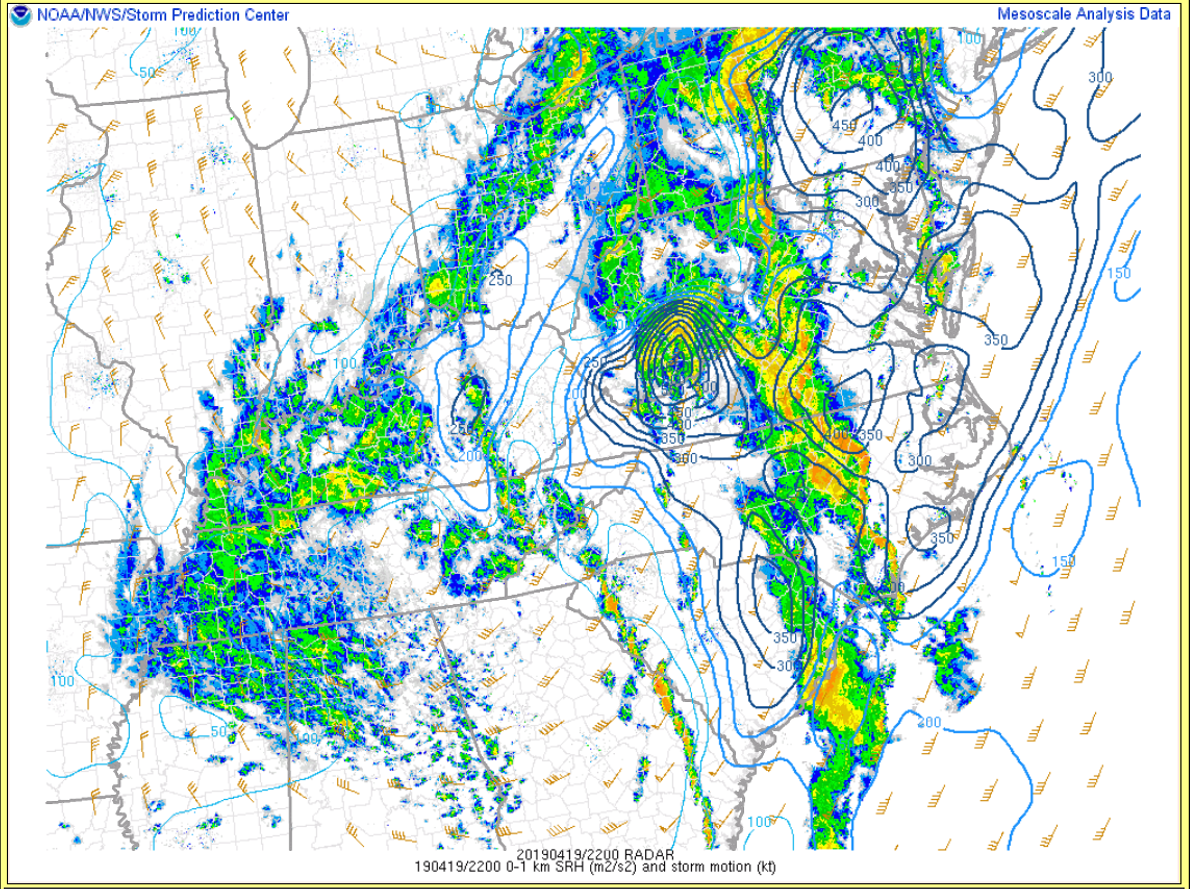 |
| Figure 9: Surface Based CAPE/CIN | Figure 10: Surface-6 km Shear | Figure 11: 0-1 km Storm Relative Helicity |
Selected Soundings from the Evening of the 19th.
 |
 |
 |
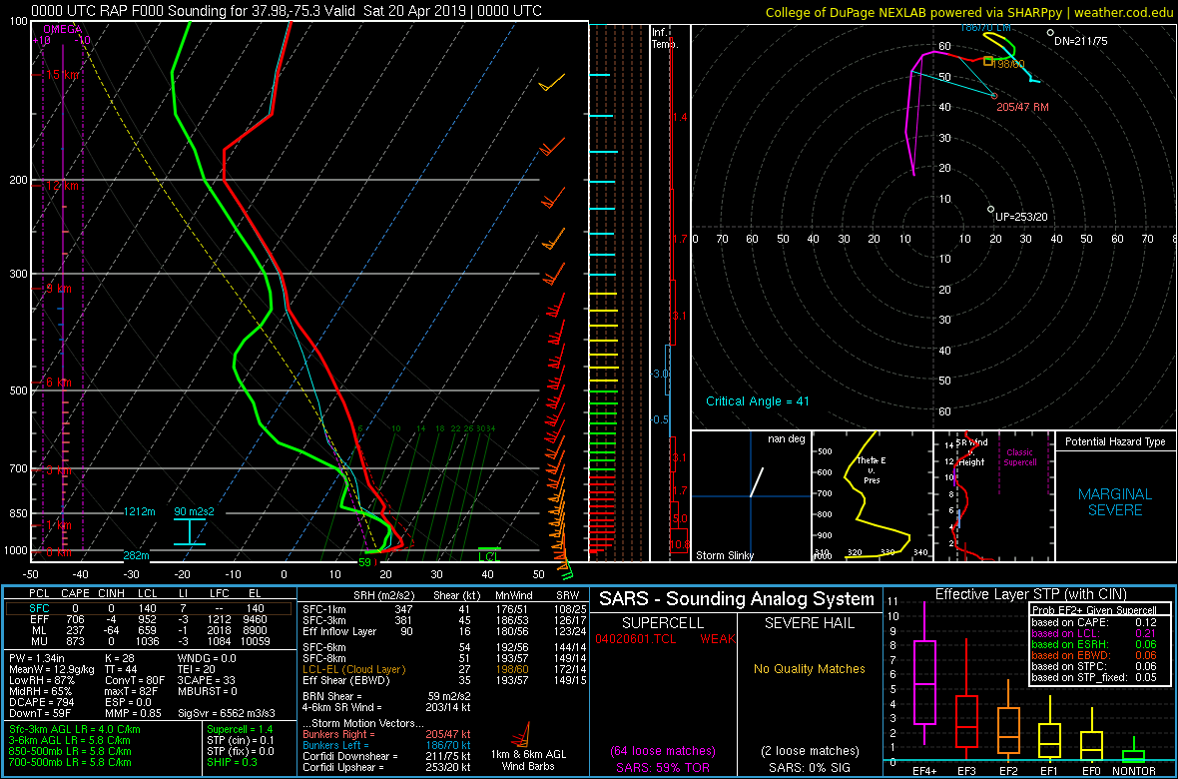 |
| Figure 12: 5 PM (21z) RAP Analysis Sounding from Northampton County, NC | Figure 13: 5 PM (21z) RAP Analysis Sounding from Wakefield, VA | Figure 14: 8 PM (00z) RAP Analysis Sounding from Charles City, VA | Figure 15: 8 PM (00z) RAP Analysis Sounding from Wallops Island, VA |
 |
Media use of NWS Web News Stories is encouraged! Please acknowledge the NWS as the source of any news information accessed from this site. |
|


 Coastal Flood
 Heat
Heat