Overview
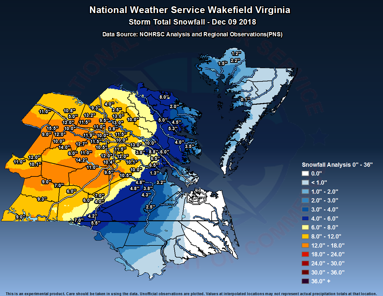
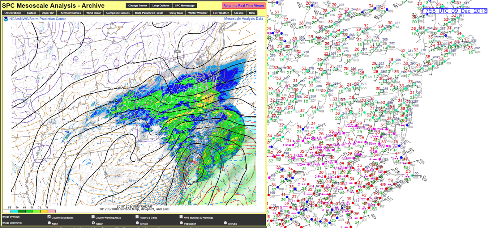
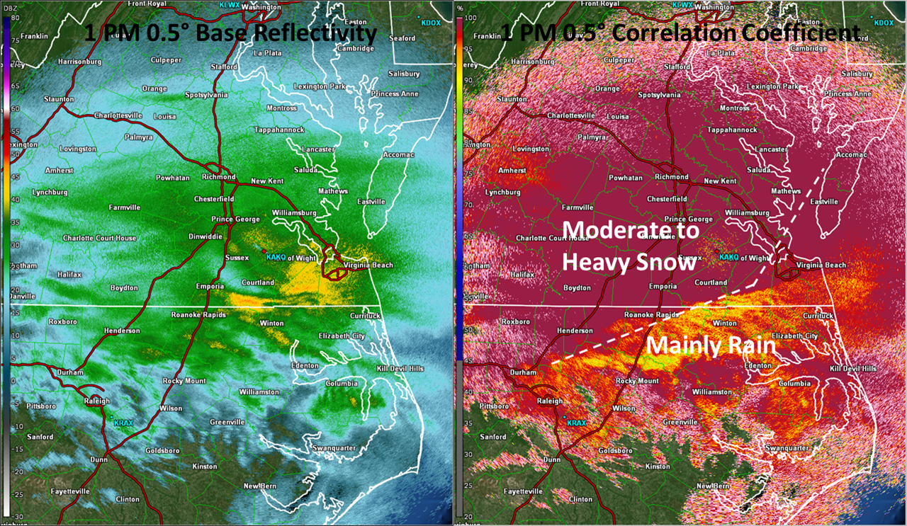
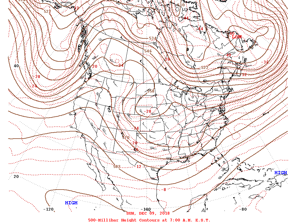
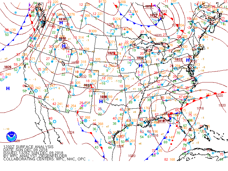
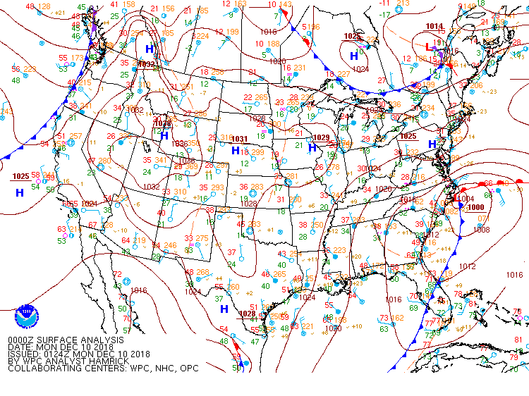
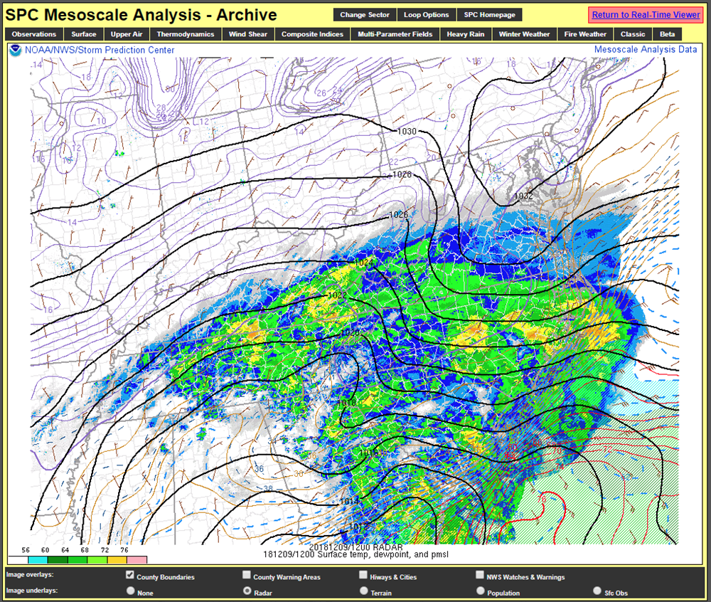
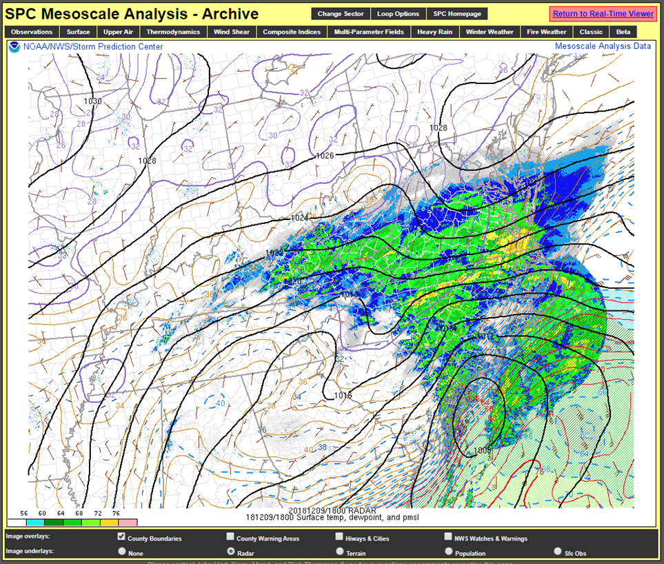
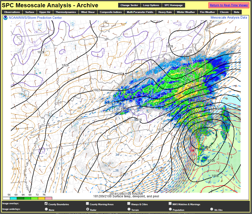
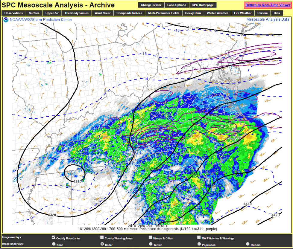
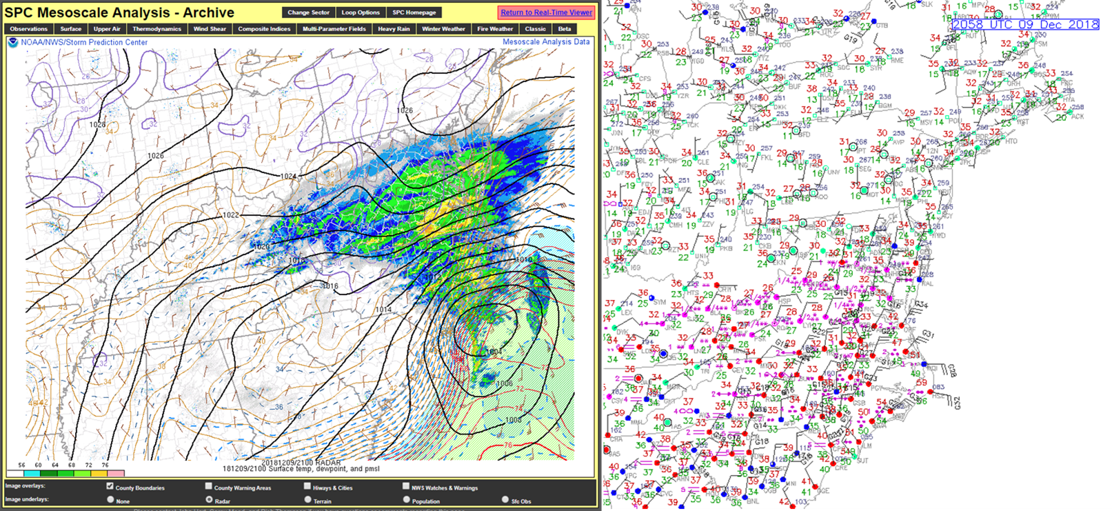
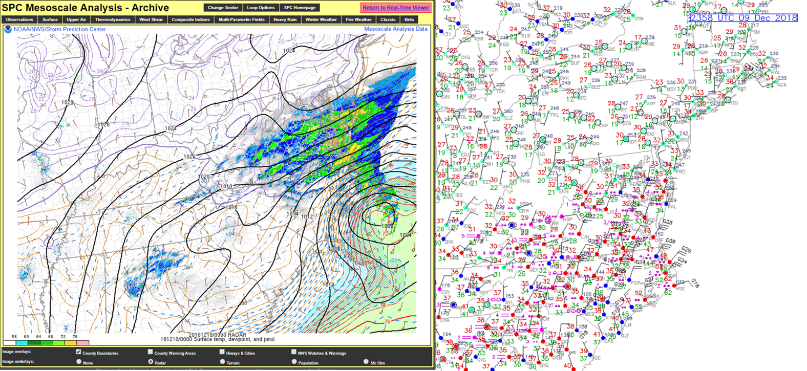
On the evening of December 8th, strong (~1036 mb) high pressure was centered from the Great Lakes to the Mid-Atlantic. At the same time, an area of low pressure was strengthening across the southeast while an upper level shortwave was moving from the southern Plains to the mid-south. The area of low pressure became centered over the Florida Panhandle as a cold air damming regime set up across interior parts of Virginia and the Carolinas, with winds (largely) out of the NNE. A large area of precipitation was impacting the Carolinas and was approaching southern VA by sunrise on the 9th. Precipitation quickly overspread most of the CWA by Sunday morning, with snow in most areas except for coastal SE VA/NE NC, where NE winds ushered in milder, maritime air. As the shortwave approached the Mid-Atlantic region, an area of 700-500 mb frontogenesis set up from W to E just south of VA/NC border around sunrise on 12/9. While light to moderate snow was reported in most areas, bands of heavy snow (rates of 1-2"/hour) set up in/near the 700-500 mb FGen axis over far southwestern portions of the Wakefield CWA. This FGen axis would serve as the focal point for the heaviest snow bands throughout the day. It is important to note that the dendritic growth zone resided in the upper part of the 700-500 mb layer (see KRIC soundings in the Environment section for more detail).
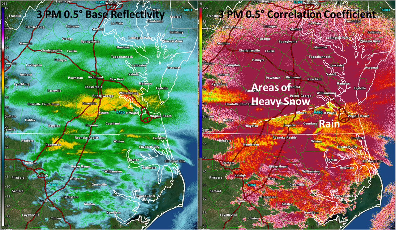
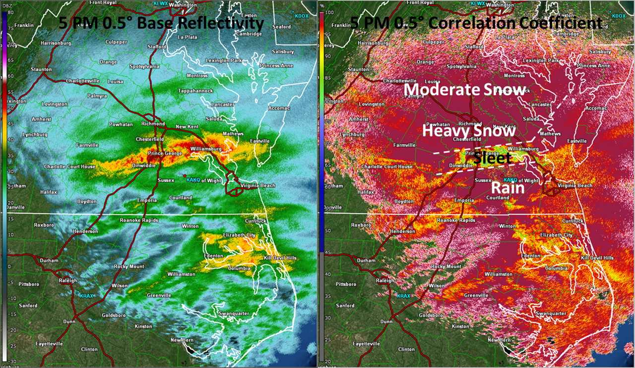
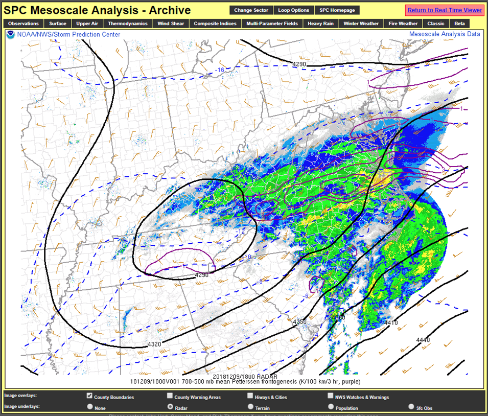
The milder, maritime airmass slowly moved from SSE to NNW throughout the day as the surface low tracked NNE just off the southeast coast. At the same time, the 700-500 FGen axis slowly moved northward. As a result, snow started changing to sleet then rain over SE VA/northern NC Sunday afternoon. The snow became heavy over central and western portions of the CWA (including the Richmond metro area) during the afternoon where temperatures remained slightly below freezing from the sufrace-850mb. Moderate to heavy snow continued throughout the afternoon from the Richmond metro to the Virginia Piedmont. This is where a widespread 9 to 14 inches of snow was reported. Snow finally changed to sleet over the central/southern Richmond metro area between 5-8 PM before the entire area of rain/sleet/snow started to weaken as drier air filtered in from the north. The snowfall resulted in numerous flight cancellations at area airports. Interstates became snow covered and numerous accidents were reported. The 11.5 inches of snow at Richmond International Airport (measured by a COOP Observer in nearby Varina) ranks as the 2nd largest December snowstorm on record (behind only the 17.2 inches that fell on Dec. 22-23, 1908).
See the Observations, Radar, and Environment sections for more specific details about the exact location of the meteorological features mentioned above.
Snowfall Maps
 |
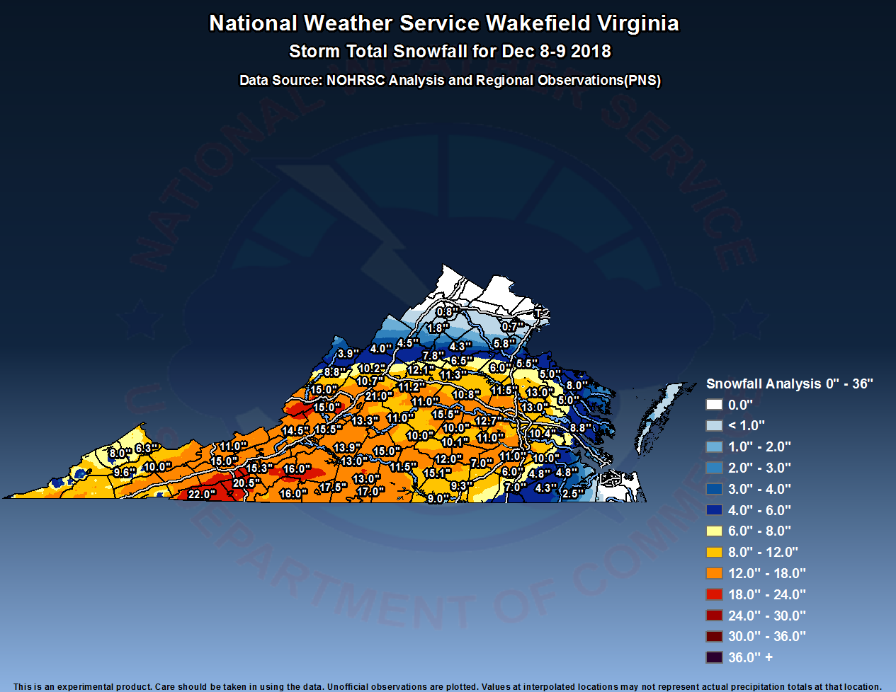 |
| Figure 1: Wakefield CWA Snowfall Map (Source: NOHRSC Analysis and Regional Observations) | Figure 2: Virginia Snowfall Map (Source: NOHRSC Analysis and Regional Observations) |
Observations
.png) |
 |
| 12/9 7 AM MSLP/Radar/T/Wind (left) and ASOS/AWOS Observations (right) | 12/9 1 PM MSLP/Radar/T/Wind (left) and ASOS/AWOS Observations (right) |
|
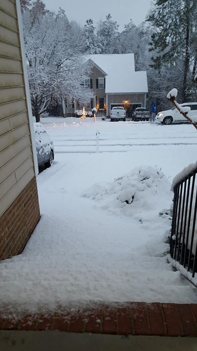
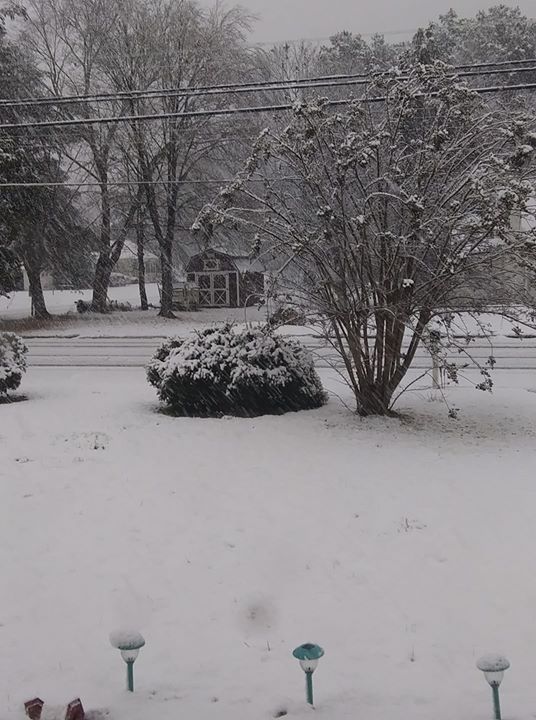
Photos
 |
 |
 |
 |
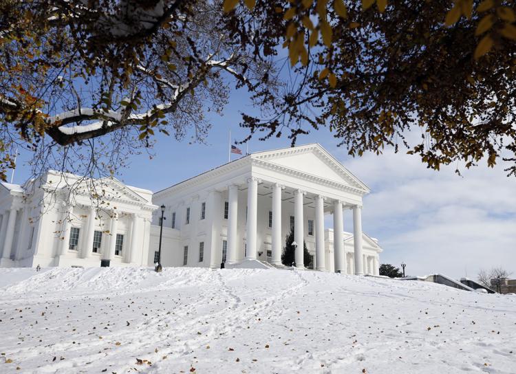
| Virginia State Capitol on 12/10 (Source: Richmond Times-Dispatch) |
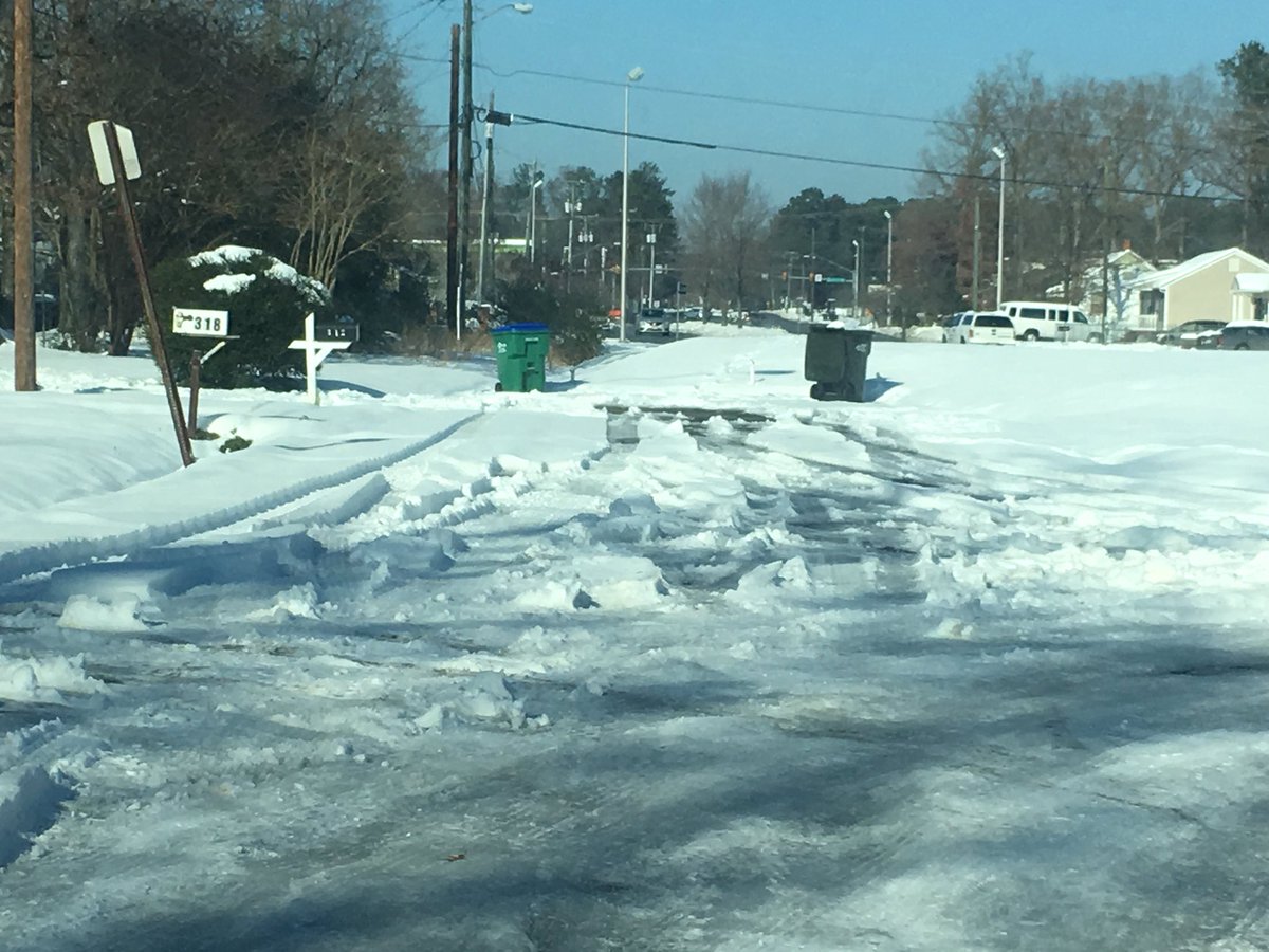
Snow covered side road off Midlothian Turnpike on 12/10 (Source: NBC12 Richmond) |
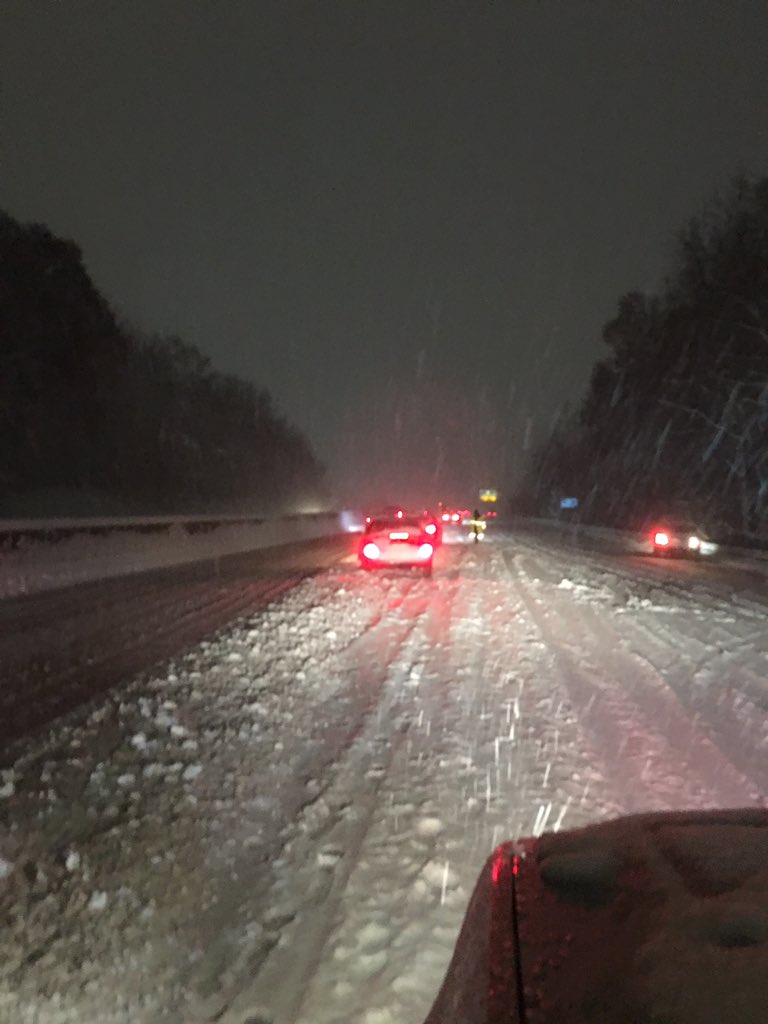
Traffic on Chippenham Parkway on the evening of 12/9 (Source: Jeff Stern - Twitter) |
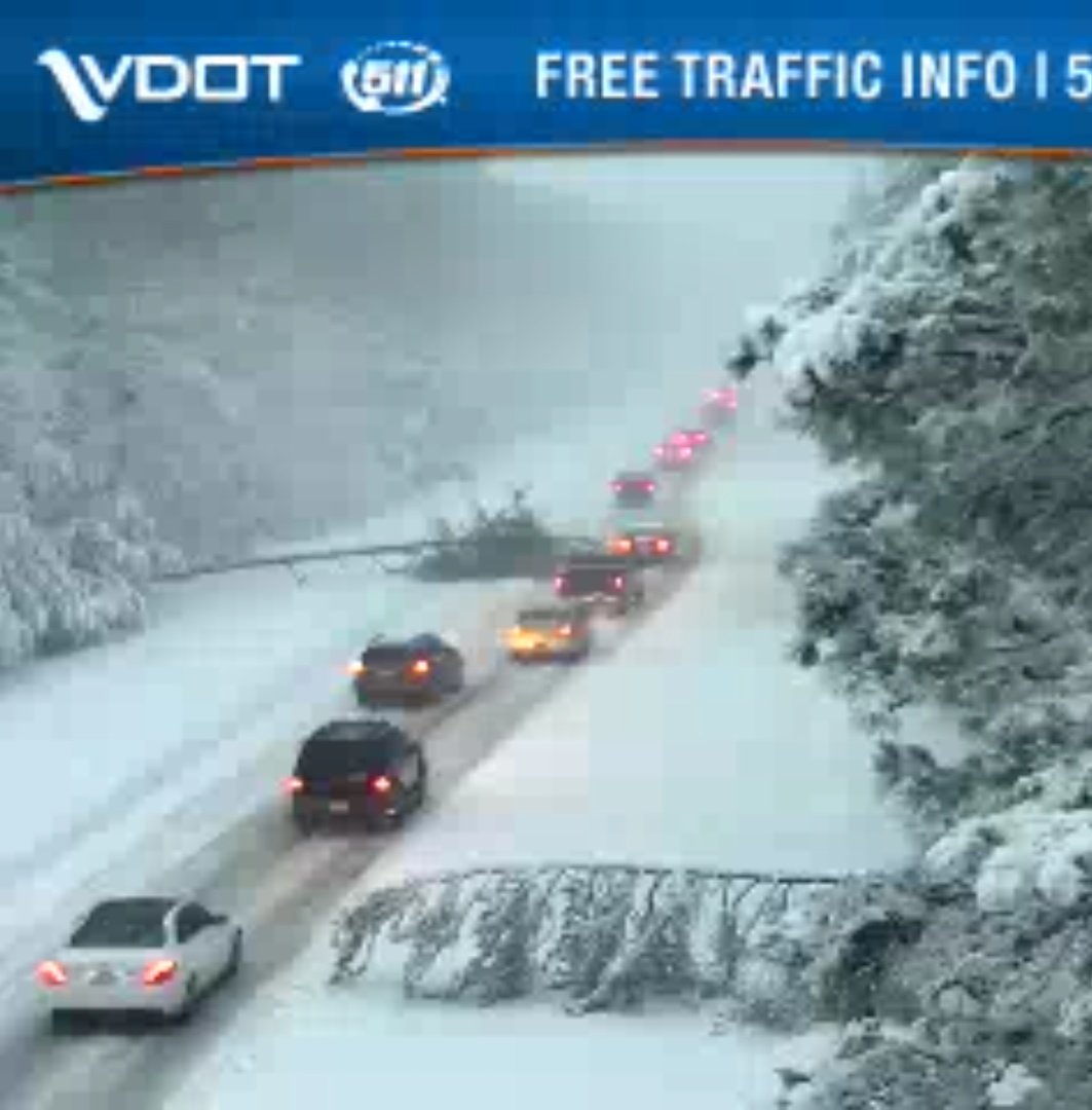
I-64 at MM 214 during the day on 12/9 (source: Matthew Baker - Twitter) |
 |
 |
 |
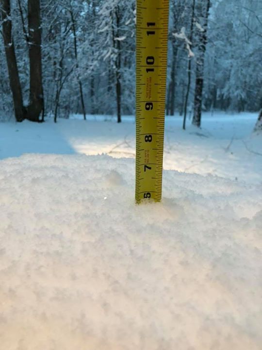
| 6" of Snow in Williamsburg (Source: Lindsey Campbell - Facebook) | Snow in Lightfoot, VA (James City/York County) (Source: S. Dawn Heyse - Facebook) |
Snow in Weems, VA (Lancaster County) (Source: Jeff Stern - Twitter) |
Radar
Selected Images
 |
 |
 |
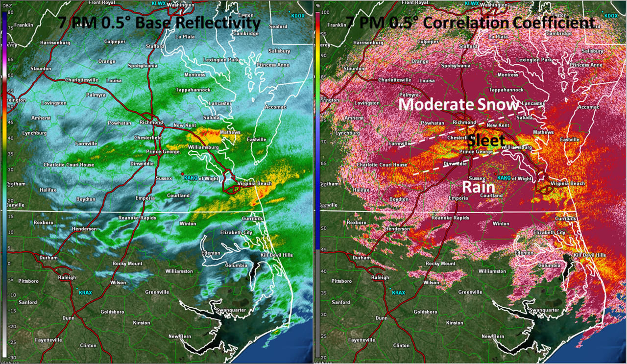 |
| 12/9 1 PM Base Reflectivity (left) and Correlation Coefficient (right) | 12/9 3 PM Base Reflectivity (left) and Correlation Coefficient (right) | 12/9 5 PM Base Reflectivty (left) and Correlation Coefficient (right) | 12/9 7 PM Base Reflectivity (left) and Correlation Coefficient (right) |
Snowfall Reports
000
NOUS41 KAKQ 101507
PNSAKQ
MDZ021>025-NCZ012>017-030>032-102-VAZ048-060>062-064>069-075>090-092-093-
095>100-509>525-110307-

Public Information Statement
National Weather Service Wakefield VA
1007 AM EST Mon Dec 10 2018

...SNOWFALL REPORTS...

Location                     Amount    Time/Date       Provider

...York...
Queens Lake                  3.0 in    0515 PM 12/09   Trained Spotter

...Westmoreland...
Hague                        8.0 in    0707 PM 12/09   Public

...Western King William...
Pollards Corner              10.0 in   0746 PM 12/09   Public

...Western Henrico (Including the City of Richmond)...
1 N Laurel                   14.1 in   0759 PM 12/09   Public
3 N Short Pump               14.0 in   0931 PM 12/09   Public
Laurel                       13.8 in   0700 AM 12/10   COCORAHS
3 ENE Short Pump             13.5 in   0830 PM 12/09   Trained Spotter
1 NNE Tuckahoe               13.5 in   0909 PM 12/09   Trained Spotter
2 N Short Pump               13.0 in   0717 PM 12/09   Trained Spotter
Longdale                     13.0 in   0850 PM 12/09   Trained Spotter
3 SSE Dumbarton              13.0 in   0854 PM 12/09   Trained Spotter
Longdale                     12.0 in   0654 PM 12/09   Trained Spotter
3 E Short Pump               11.9 in   0900 PM 12/09   Trained Spotter
2 E Short Pump               11.9 in   0702 AM 12/10   COCORAHS
1 N Downtown Richmond        11.5 in   0747 PM 12/09   Public
2 SSW Dumbarton              11.5 in   0700 AM 12/10   COCORAHS
2 NNE Short Pump             11.0 in   0736 PM 12/09   Trained Spotter
3 NNW Downtown Richmond      10.0 in   0609 PM 12/09   Public

...Western Hanover...
1 SW Ashland                 9.5 in    0554 PM 12/09   CO-OP Observer
Hewlett                      9.3 in    0700 AM 12/10   COCORAHS
2 NNW Gilman                 13.2 in   0700 AM 12/10   COCORAHS
1 SW Ashland                 11.5 in   0801 PM 12/09   CO-OP Observer
Montpelier                   11.5 in   0932 PM 12/09   Public

...Western Chesterfield...
3 WSW Beach                  14.2 in   0700 AM 12/10   COCORAHS
3 S Midlothian               13.5 in   1019 PM 12/09   Trained Spotter
Midlothian                   12.7 in   0700 AM 12/10   COCORAHS
4 SSW Midlothian             11.0 in   0700 AM 12/10   COCORAHS
4 S Bon Air                  10.5 in   0556 PM 12/09   Trained Spotter

...Sussex...
Nws Offfice                  4.8 in    1200 AM 12/10   COOP
Wakefield                    3.8 in    0800 AM 12/10   COCORAHS

...Surry...
Claremont                    5.5 in    0700 AM 12/10   COCORAHS

...Southampton...
1 SSW Berlin                 4.3 in    0700 AM 12/10   COCORAHS

...Prince George...
1 S Petersburg               9.5 in    0514 PM 12/09   Trained Spotter
1 SE Jordans Point           9.5 in    0517 PM 12/09   Trained Spotter
1 NE Hopewell                12.0 in   0700 AM 12/10   COCORAHS
2 SW Hopewell                11.5 in   0756 PM 12/09   Public
1 N Prince George Golf       10.5 in   0450 PM 12/09   NWS Employee
1 S Birchett Estate          10.5 in   0557 PM 12/09   Trained Spotter
1 SE Jordans Point           10.1 in   0912 PM 12/09   Trained Spotter
4 NW Barham                  10.0 in   0510 PM 12/09   Trained Spotter
2 SSE Fort Lee               10.0 in   0730 PM 12/09   NWS Employee

...Prince Edward...
Farmville                    12.0 in   0410 PM 12/09   Public
1 ENE Elam                   11.0 in   0632 PM 12/09   Emergency Mngr
Farmville                    10.1 in   0700 AM 12/10   COCORAHS

...Powhatan...
Genito                       14.0 in   0754 PM 12/09   Public
1 WNW Macon                  10.0 in   0555 PM 12/09   Amateur Radio

...Northumberland...
2 E Howland                  2.7 in    0800 AM 12/10   COCORAHS
Lottsburg 2.3 NNE            2.0 in    0700 AM 12/10   COCORAHS
Lilian                       1.5 in    0730 PM 12/09   Trained Spotter

...New Kent...
New Kent                     10.0 in   0708 PM 12/09   Public

...Middlesex...
Stampers                     4.0 in    0700 AM 12/10   COCORAHS

...Mecklenburg...
Clarksville                  9.0 in    0700 AM 12/10   COOP

...Mathews...
North                        3.5 in    0700 AM 12/10   COOP

...Lunenburg...
Victoria                     9.0 in    0513 PM 12/09   Public

...Lancaster...
1 ESE Mollusk                5.5 in    0700 AM 12/10   COCORAHS
1 SSE Mollusk                5.3 in    0738 PM 12/09   Trained Spotter
1 NNW Mollusk                4.5 in    0544 PM 12/09   Public

...James City...
1 SW Toano                   8.8 in    0702 AM 12/10   COCORAHS
Toano                        6.8 in    0710 PM 12/09   Public
1 N Five Forks               6.5 in    0700 AM 12/10   COCORAHS
1 ESE Centerville            6.5 in    0700 AM 12/10   COCORAHS
Norge                        6.0 in    0750 PM 12/09   Trained Spotter
2 N Five Forks               5.6 in    0700 AM 12/10   COCORAHS
2 SSW Ewell                  5.2 in    0720 AM 12/10   COCORAHS
1 E Toano                    5.0 in    0517 PM 12/09   Public
1 ESE Centerville            4.0 in    0508 PM 12/09   Trained Spotter

...Isle of Wight...
Comet                        3.2 in    0600 AM 12/10   COCORAHS

...Greensville...
1 N Purdy                    7.0 in    0851 PM 12/09   Trained Spotter
Slates Corner                4.2 in    0700 AM 12/10   COCORAHS

...Goochland...
Oilville                     10.0 in   0718 PM 12/09   Public

...Gloucester...
1 SSE Gloucester Courthouse  6.0 in    0613 PM 12/09   Public
1 NE Ark                     5.3 in    0500 PM 12/09   Trained Spotter
2 E Clay Bank                4.8 in    0800 AM 12/10   COCORAHS
Gloucester Point             1.6 in    0700 AM 12/10   COCORAHS

...Eastern Louisa...
Gum Spring                   12.0 in   0628 PM 12/09   Public
3 ESE Apple Grove            10.8 in   0555 PM 12/09   Amateur Radio

...Eastern Henrico...
Richmond International       9.0 in    0530 PM 12/09   Official NWS Obs
1 WSW Bottoms Bridge         13.5 in   0859 PM 12/09   Trained Spotter
Richmond International       11.5 in   0815 PM 12/09   CO-OP Observer
Varina                       11.5 in   0700 AM 12/10   COCORAHS
Highland Springs             10.0 in   0613 PM 12/09   Trained Spotter

...Eastern Hanover...
2 WSW Mechanicsville         12.0 in   0900 PM 12/09   Trained Spotter
3 SSE Mechanicsville         11.5 in   0800 PM 12/09   Trained Spotter

...Eastern Essex...
1 SE Montague                5.0 in    0622 PM 12/09   Public

...Eastern Chesterfield (Including Col. Heights)...
3 NW Hopewell                8.4 in    0515 PM 12/09   NWS Employee
2 SSW Chesterfield           12.0 in   0643 PM 12/09   NWS Employee
Meadowville                  11.0 in   0500 AM 12/10   COCORAHS
3 NW Hopewell                10.4 in   0901 PM 12/09   NWS Employee

...Dorchester...
1 SE East New Market         2.2 in    0400 AM 12/10   COCORAHS
2 SE Linkwood                1.5 in    0900 AM 12/10   COCORAHS
2 ENE East New Market        1.2 in    0630 PM 12/09   Public
2 ENE East New Market        1.2 in    0630 PM 12/09   Trained Spotter

...Dinwiddie...
1 NNW Addison                11.0 in   0716 PM 12/09   NWS Employee

...Cumberland...
Cartersville                 9.0 in    0430 PM 12/09   Trained Spotter
Cartersville                 12.0 in   0638 PM 12/09   Trained Spotter

...Caroline...
2 S Dawn                     13.0 in   0812 PM 12/09   Cocorahs
1 S Dawn                     13.0 in   0700 AM 12/10   COCORAHS
&&
Environment
Synoptic summary.
 |
 |
 |
| Figure 1: 12/9 7 AM 500hPa Analysis | Figure 2: 12/9 7 AM Surface Analysis | Figure 3: 12/9 7 PM Surface Analysis |
Near-storm MSLP/Temp/Wind summary.
 |
 |
 |
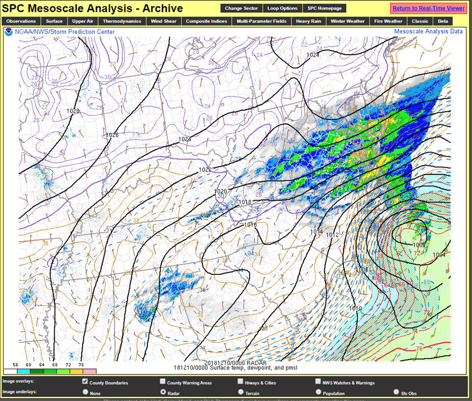 |
| Figure 4: 12/9 7 AM MSLP/T/Wind | Figure 5: 12/9 1 PM MSLP/T/Wind | Figure 6: 12/9 4 PM MSLP/T/Wind | Figure 7: 12/9 7 PM MSLP/T/Wind |
Radar/700-500 mb Frontogenesis.
 |
 |
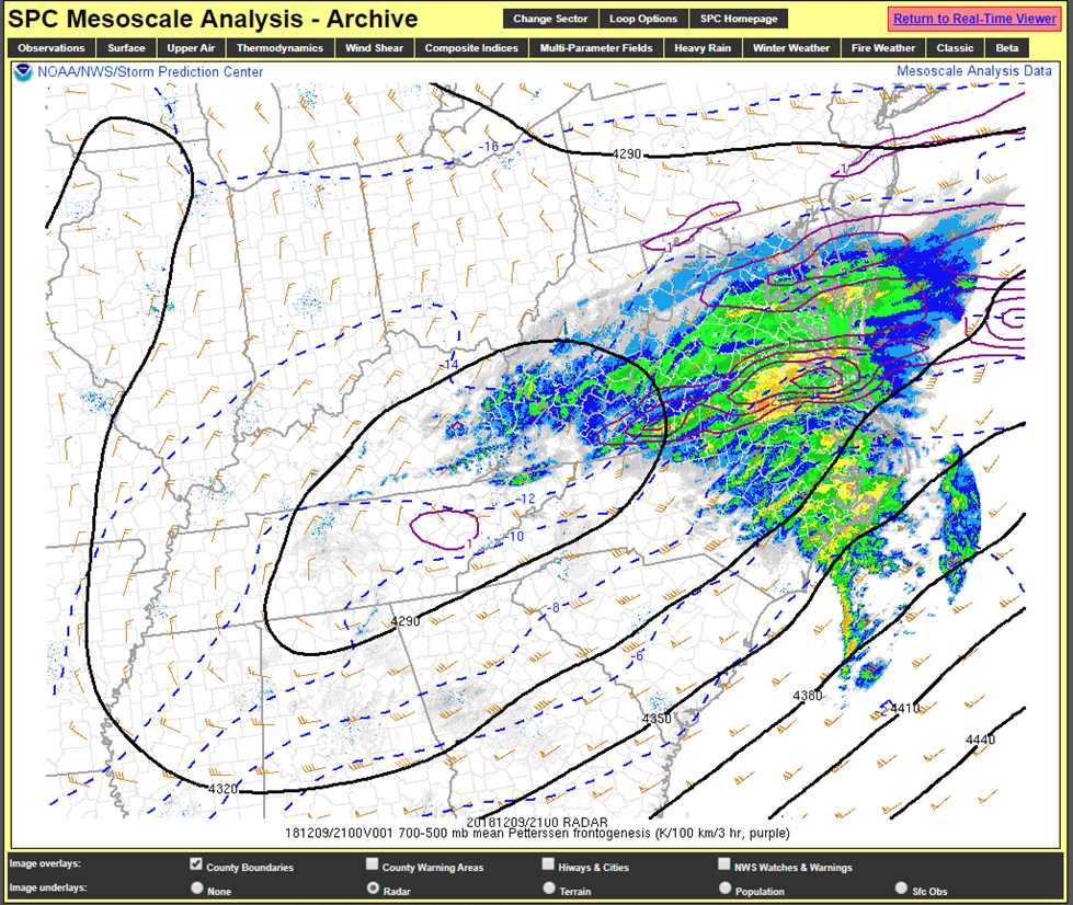 |
| Figure 8: 12/9 7 AM Radar/700-500 mb Frontogenesis | Figure 9: 12/9 1 PM Radar/700-500 mb Frontogenesis | Figure 10: 12/9 4 PM Radar/700-500 mb Frontogenesis |
NAM Analysis Soundings.
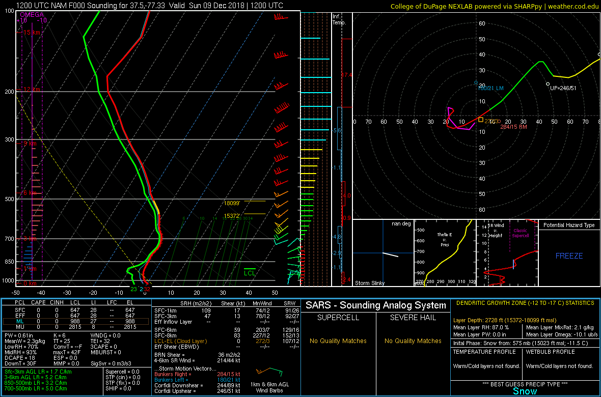 |
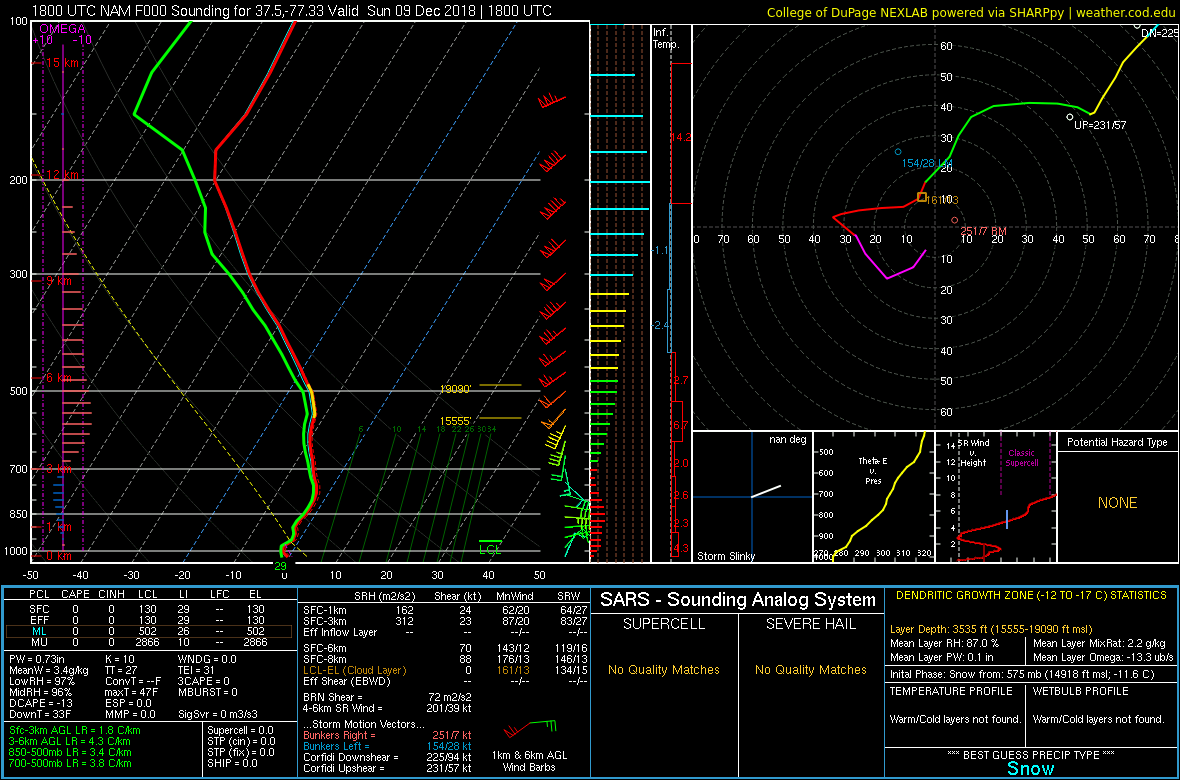 |
 |
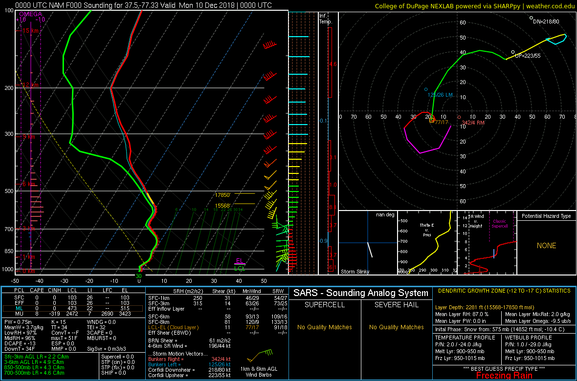 |
| Figure 11: 12/9 7 AM KRIC Sounding | Figure 12: 12/9 1 PM KRIC Sounding | Figure 13: 12/9 1 PM KPHF Sounding | Figure 14: 12/9 7 PM KRIC Sounding |
 |
Media use of NWS Web News Stories is encouraged! Please acknowledge the NWS as the source of any news information accessed from this site. |
|


 Coastal Flood
 Heat
Heat