
Heavy to excessive rainfall may produce additional flash flooding Wednesday across parts of the southern Plains where the greatest risk is along the Red River Valley into western Arkansas. Scattered severe thunderstorms are also possible centered on central Texas to eastern Oklahoma and western Arkansas. Large hail, damaging wind, and a few tornadoes will be possible. Read More >
Overview
At 8 PM on the evening before the flooding rain event, an upper-level low was located over northeastern Missouri. This put our CWA in southwest flow aloft, as vorticity maxima rotated around the upper low. At the surface, WPC analysis indicated that a frontal boundary was situated from Charlottesville to Petersburg to Norfolk with a secondary surface low about 100 miles west of Harrisonburg, VA. Showers and thunderstorms were ongoing (and moving to the east) along the boundary from central to southeastern Virginia, with another area of showers/t-storms closer to the secondary surface low in West Virginia.
Despite the fact that showers/t-storms passed through central/southern VA a few hours before, elevated instability was present across much of central/southeast VA, with MUCAPE values close to 1000 J/kg in spots at 1 AM on 6/22. In addition, abundant moisture was in place throughout the region, with PW values between 2.2 and 2.3 inches (around the max observed values for late June). Finally, RAP analysis indicated that a subtle mid-level shortwave/vort max was approaching from the W/SW.
By 3 AM (07z) Friday, showers/t-storms near the surface low started to intensify as they entered the area with higher (elevated) instability just west of RIC. 7.10 inches of rain fell at RIC between 3:45 and 6:00AM Friday as t-storms kept re-developing over the same area. This was coincident with the surface boundary slowly lifting north toward RIC (a more detailed timeline can be seen on the radar images). Thus, low-level convergence was enhanced due to the approaching boundary in the area with elevated MUCAPE already in place. The t-storms that affected Richmond slowly dissipated after 6 AM as they moved northeastward into areas with less instability (see 11z MUCAPE/radar mesoanalysis).
Richmond set an all-time record hourly rainfall, with 4.09” recorded between 3:54 and 4:54 AM on 6/22/18. This shattered the previous record of 2.82” on 7/22/1969. In addition, June 22nd ended up being the second wettest day in Richmond history (going back to 1887)! The only day that was wetter was back on 8/12/1955 when RIC recorded 8.79” (associated with Hurricane Connie).
Louisa County:
After 5 AM, precipitation became enhanced as low level convergence increased over Louisa County (can easily be seen with 975mb RAP Analysis). Central parts of the county picked up over 6 inches of rain during the early morning hours of 6/22.
Impacts and Reports:
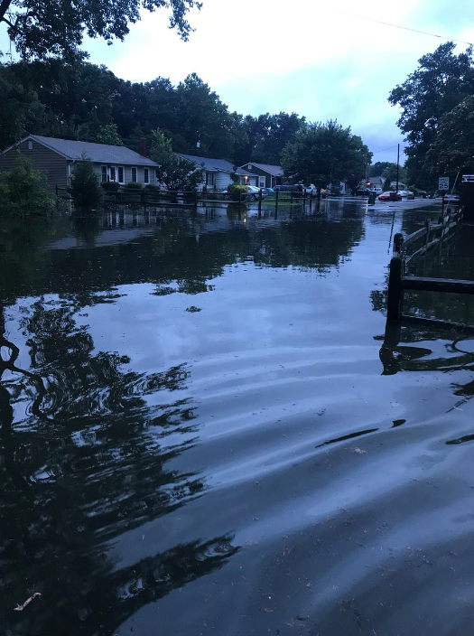
The Richmond Airport closed for a few hours during the morning of June 22nd due to power outages, flooded roadways. It re-opened around 9 AM. Flash flooding was occurred in several residential areas in and around Richmond, including in some mobile homes in Manchester. The worst flash flooding was confined to parts of the City of Richmond, Henrico, and Hanover counties as the heaviest rainfall totals were confined to a small area. For example, areas in northeastern Chesterfield County around 15 miles south of RIC reported less than an inch of rainfall! Numerous road closures were reported in Louisa County due to the flooding.
 |
Flooding
 |
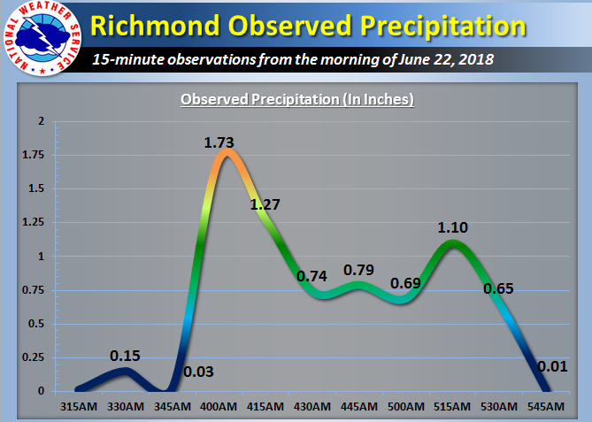 |
| 24-hour MRMS Rainfall | 15-minute rainfall observations at RIC |
Photos & Video:
 |
 |
 |
 |
| Water rescue in Henrico County (WTVR CBS 6 Richmond) |
Flooding at RIC Airfield (Richmond Airport) |
Street flooding (Twitter: @Salty_mermaiid) |
Glenwood Ave near Government Rd (Twitter: @Kerri8News) |
Radar:
 |
 |
 |
 |
| 3:15 AM Reflectivity | 4:00 AM Reflectivity | 5:00 AM Reflectivity | 6:00 AM Reflectivity |
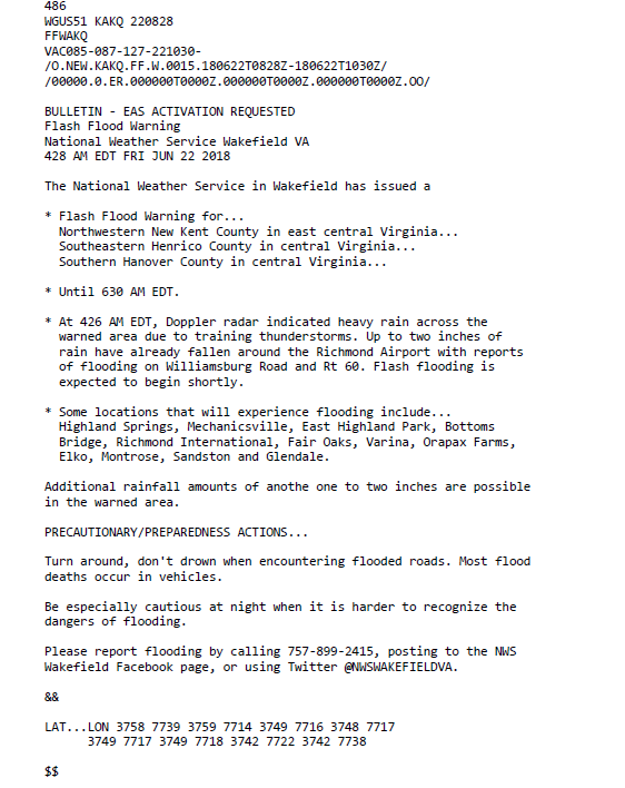
Related Warnings:
Environment
 |
 |
 |
| 6/21/18 8 PM Surface Map | 6/21/18 500hPa Heights and Vorticity | 6/22/18 1 AM Precipitable Water (Inches) |
Near-storm environment
 |
 |
 |
| 1 AM MUCAPE/Radar | 3 AM Surface Winds/Divergence | 4 AM MUCAPE/Radar |
Additional environmental data
 |
 |
| 7 AM MUCAPE/Radar | 8 AM 975mb Winds |
 |
Media use of NWS Web News Stories is encouraged! Please acknowledge the NWS as the source of any news information accessed from this site. |
|


 Coastal Flood
 Heat
Heat