
Scattered showers and isolated strong/severe thunderstorms are expected across the Southeast through Monday with scattered instances of flash flooding possible across portions of southern Georgia and northern Florida. Dry and windy conditions may produce fire weather conditions across much of the Great Plains, especially in the Northern Plains where critical fire weather conditions are expected. Read More >
Last Map Update: Mon, Mar 10, 2025 at 12:30:07 am PDT


|
Text Product Selector (Selected product opens in current window)
|
|


 Hanford Radar
 Edwards Radar
 Recent Temperatures
 Satellite
 Weather Map
 Central Valley and Sierra Nevada Smoke Forecast
 Experimental Fog Severity Index
 Social Media
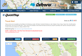 Caltrans QuickMap
 Drought