
Surface Analysis/Infrared Satellite. (12/24 - 12/25/2020). Credit Weather Prediction Center.
Christmas Eve into Christmas Day was a wild ride in weather across Eastern North Carolina. An area of low pressure was tracking well to our northwest across the Appalachian Mountains Christmas Eve day, with a very strong trailing cold front. For most of the day we were well removed from the front, but the southerly winds ahead of it pushed temperatures toward 70 degrees over much of Eastern North Carolina by that afternoon. At the same time very strong winds were occurring in the atmosphere just above the surface. These winds increase quickly with height, meaning they were much stronger with increasing elevation. In addition the wind direction changed or veered with height, from southerly near the surface to southwest and eventually westerly thousands of feet up. Instability from the warm temperatures, and the strength of the wind and how it changed with height created conditions favorable for severe thunderstorms producing damaging winds and even tornadoes.
Multiple lines of thunderstorms moved through on Christmas Eve, producing strong winds and in some cases some damage. Multiple severe thunderstorm and tornado warnings were issued. A 71 MPH wind gust was measured at Cedar Island, in far Eastern Carteret County with thunderstorm damage near Pollocksville, in Jones County. Rainfall was mainly under an inch, but more than 2 inches fell from Morehead City north and east, including over 4" on Ocracoke Island. Despite strong southerly winds, we did not experience any major coastal flooding. Some standing rain water was found along NC 12 in Dare County along with windblown sand, but only slow going was reported, no closures. Large waves did impact our coastline, with 22 foot waves reported at Diamond Shoals.
Using the tabs below scroll through for more information and graphics.
Heavy Rain
The image below shows that most of Eastern North Carolina saw less than an inch of rain. However some heavier rain and thunderstorms began to "train" or move over and over the same areas. This occurred especially from near Morehead City north and east, across the Outer Banks. These areas saw widespread amounts of 1" to 2", with isolated amounts closer to 3". Scroll down for an image of the rainfall along with some of the individual text reports.
24 Hour Rainfall Reports
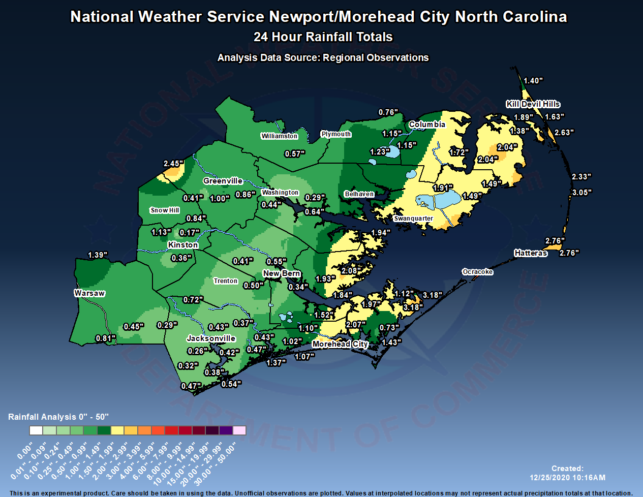
24 Hour Precipitation Reports (12/24/20 - 12/25/2020)
000 NOUS42 KMHX 251454 PNSMHX NCZ029-044>047-079>081-090>092-094-193>196-198-199-203>205-260251- Public Information Statement National Weather Service Newport/Morehead City NC 951 AM EST Fri Dec 25 2020 ...PRECIPITATION REPORTS... Location Amount Time/Date Provider ...North Carolina... ...Beaufort County... Belhaven 1.38 in 0923 AM 12/25 CWOP Bath 0.7 N 0.64 in 0700 AM 12/25 COCORAHS Chocowinity 0.2 W 0.44 in 0800 AM 12/25 COCORAHS Bunyan RAWS 0.29 in 0913 AM 12/25 RAWS Washington (OCW AWOS) 0.25 in 0915 AM 12/25 AWOS ...Carteret County... Cedar Island RAWS 3.18 in 0925 AM 12/25 RAWS Cedar Island RAWS 3.18 in 0825 AM 12/25 RAWS Pine Knoll Shores 1.4 E 2.48 in 0700 AM 12/25 COCORAHS Morehead City 0.1 E 2.38 in 0800 AM 12/25 COCORAHS Morehead City 5.7 W 2.15 in 0700 AM 12/25 COCORAHS Morehead City 2.4 WNW 2.10 in 0700 AM 12/25 COCORAHS Beaufort 5.3 N 2.07 in 0800 AM 12/25 COCORAHS Atlantic Beach 0.6 W 2.02 in 0732 AM 12/25 COCORAHS Beaufort 15.1 N 1.97 in 0700 AM 12/25 COCORAHS Morehead City 1.91 in 0915 AM 12/25 CWOP Newport 1.60 in 0931 AM 12/25 CWOP Newport 1.60 in 0916 AM 12/25 CWOP Harkers Island 3.2 NE 1.43 in 0700 AM 12/25 COCORAHS Newport 5.6 SW 1.43 in 0630 AM 12/25 COCORAHS 0.2 SW Newport 1.40 in 0931 AM 12/25 CWOP 0.2 SW Newport 1.40 in 0916 AM 12/25 CWOP Emerald Isle 1.37 in 0944 AM 12/25 CWOP Emerald Isle 1.37 in 0923 AM 12/25 CWOP Beaufort 3.7 NNW 1.26 in 0800 AM 12/25 COCORAHS Cedar Island 0.3 SSE 1.12 in 0657 AM 12/25 COCORAHS Newport 1.12 in 0916 AM 12/25 CWOP Newport 1.10 in 1200 AM 12/25 COOP Indian Beach 1.07 in 0931 AM 12/25 CWOP Indian Beach 1.07 in 0916 AM 12/25 CWOP Newport 1.05 in 0917 AM 12/25 CWOP Ocean 0.5 S 1.02 in 0830 AM 12/25 COCORAHS Emerald Isle 2.1 E 0.99 in 0823 AM 12/25 COCORAHS Beaufort 0.98 in 0935 AM 12/25 AWS Croatan RAWS 0.93 in 0905 AM 12/25 RAWS Beaufort (MRH ASOS) 0.92 in 0858 AM 12/25 ASOS Beaufort 0.5 W 0.90 in 0800 AM 12/25 COCORAHS Emerald Isle 0.2 ENE 0.80 in 0700 AM 12/25 COCORAHS Cape Carteret 1.5 NE 0.77 in 0800 AM 12/25 COCORAHS Williston 0.9 SW 0.73 in 0700 AM 12/25 COCORAHS Cape Carteret 0.62 in 0917 AM 12/25 CWOP Bogue Field (NJM ASOS) 0.51 in 0857 AM 12/25 AWOS Cedar Point 0.9 WSW 0.43 in 0518 AM 12/25 COCORAHS ...Craven County... Havelock 1.9 SSE 1.52 in 0635 AM 12/25 COCORAHS New Bern 7.7 ESE 0.92 in 0700 AM 12/25 COCORAHS New Bern 7.5 ESE 0.80 in 0700 AM 12/25 COCORAHS Perrytown (COOP) 0.65 in 0800 AM 12/25 COOP New Bern 5.3 SW 0.57 in 0822 AM 12/25 COCORAHS Geneseo 0.56 in 0930 AM 12/25 CWOP Geneseo 0.56 in 0915 AM 12/25 CWOP Cherry Point (NKT ASOS) 0.55 in 0854 AM 12/25 AWOS New Bern 1.3 NNE 0.55 in 0700 AM 12/25 COCORAHS New Bern 4.9 SW 0.50 in 0700 AM 12/25 COCORAHS James City 2.0 S 0.48 in 0700 AM 12/25 COCORAHS New Bern 4.6 SW 0.48 in 0800 AM 12/25 COCORAHS Trent Woods 1.2 ENE 0.46 in 0600 AM 12/25 COCORAHS Trent Woods 1.0 NNE 0.45 in 0700 AM 12/25 COCORAHS New Bern 8.8 W 0.41 in 0700 AM 12/25 COCORAHS New Bern 1.5 NW 0.38 in 0820 AM 12/25 COCORAHS New Bern RAWS 0.38 in 0917 AM 12/25 RAWS 1 SSW James City 0.34 in 0935 AM 12/25 AWS New Bern (EWN ASOS) 0.33 in 0906 AM 12/25 ASOS New Bern 5.2 SE 0.19 in 0800 AM 12/25 COCORAHS ...Dare County... Rodanthe 1.0 SSE 3.05 in 0700 AM 12/25 COCORAHS Frisco (HSE ASOS) 2.84 in 0851 AM 12/25 ASOS Buxton 2.76 in 0930 AM 12/25 CWOP Buxton 2.76 in 0915 AM 12/25 CWOP Nags Head 2.63 in 0935 AM 12/25 CWOP Frisco 2.43 in 0931 AM 12/25 CWOP Frisco 2.43 in 0915 AM 12/25 CWOP Rodanthe 2.33 in 0943 AM 12/25 CWOP Kill Devil Hills 2.14 in 0942 AM 12/25 CWOP Dare Bomb Range RAWS 2.04 in 0928 AM 12/25 RAWS Dare Bomb Range RAWS 2.04 in 0828 AM 12/25 RAWS Manteo 2.8 NW 1.89 in 0800 AM 12/25 COCORAHS Nags Head 0.2 NW 1.63 in 0800 AM 12/25 COCORAHS Southern Shores 0.5 NNE 1.40 in 0700 AM 12/25 COCORAHS Manteo (MQI AWOS) 1.38 in 0915 AM 12/25 AWOS ...Duplin County... Mount Olive 2.4 SW 1.39 in 0730 AM 12/25 COCORAHS 1.5 SE Wallace 0.81 in 0600 AM 12/25 UCOOP Wallace 6.2 ENE 0.45 in 0638 AM 12/25 COCORAHS ...Greene County... Hookerton 0.5 ESE 0.84 in 0700 AM 12/25 COCORAHS ...Hyde County... Ocracoke 0.2 ESE 4.11 in 0800 AM 12/25 COCORAHS Fairfield RAWS 1.91 in 0917 AM 12/25 RAWS 4 NE Engelhard 1.49 in 0935 AM 12/25 AWOS 4 NE Engelhard 1.49 in 0915 AM 12/25 AWOS ...Jones County... New Bern 4.4 SW 0.45 in 0709 AM 12/25 COCORAHS ...Lenoir County... Kinston 5.1 WNW 1.13 in 0700 AM 12/25 COCORAHS Kinston 3.7 WNW 0.98 in 0700 AM 12/25 COCORAHS Kinston 7.0 SW 0.36 in 0700 AM 12/25 COCORAHS Kinston (ISO AWOS) 0.17 in 0856 AM 12/25 AWOS ...Martin County... Williamston 8.9 SSE 0.57 in 0600 AM 12/25 COCORAHS ...Onslow County... Richlands 2.8 NW 0.72 in 0800 AM 12/25 COCORAHS Jacksonville 3.3 W 0.57 in 0800 AM 12/25 COCORAHS Sneads Ferry 0.54 in 0915 AM 12/25 CWOP Holly Ridge 4.9 ENE 0.47 in 0700 AM 12/25 COCORAHS Hubert 3.7 ENE 0.47 in 0725 AM 12/25 COCORAHS Jacksonville 7.0 W 0.47 in 0641 AM 12/25 CWOP Jacksonville 4.5 NW 0.46 in 0700 AM 12/25 COCORAHS Jacksonville 1.5 NNW 0.43 in 0700 AM 12/25 COCORAHS Swansboro 3.3 NW 0.43 in 0700 AM 12/25 COCORAHS Camp Lejeune 1.4 NW 0.42 in 0700 AM 12/25 COCORAHS Sneads Ferry 1.2 SSW 0.38 in 0700 AM 12/25 COCORAHS Hoffman RAWS 0.37 in 0910 AM 12/25 RAWS Sandy Run RAWS 0.32 in 0919 AM 12/25 RAWS Jacksonville 0.31 in 0945 AM 12/25 CWOP Richlands (OAJ AWOS) 0.29 in 0856 AM 12/25 AWOS Jacksonville (NCA ASOS) 0.26 in 0856 AM 12/25 AWOS ...Pamlico County... Oriental 4.3 NNW 2.08 in 0700 AM 12/25 COCORAHS Oriental 2.01 in 0941 AM 12/25 CWOP Oriental 2.01 in 0921 AM 12/25 CWOP Lowland 0.2 SE 1.94 in 0700 AM 12/25 COCORAHS Merritt 1.5 WSW 1.93 in 0700 AM 12/25 COCORAHS Oriental 2.0 WSW 1.84 in 0900 AM 12/25 COCORAHS Oriental 5.2 NE 1.61 in 0700 AM 12/25 COCORAHS Grantsboro 4.6 SSW 0.90 in 0804 AM 12/25 COCORAHS ...Pitt County... Fountain 0.1 NE 2.45 in 0700 AM 12/25 COCORAHS Greenville 1.4 SE 1.23 in 0700 AM 12/25 COCORAHS Greenville 7.3 SSE 1.01 in 0800 AM 12/25 COCORAHS Winterville 2.6 ENE 1.00 in 0725 AM 12/25 COCORAHS Greenville 7.1 SSE 0.91 in 0700 AM 12/25 COCORAHS Greenville 4.3 SSE 0.90 in 0800 AM 12/25 COCORAHS Greenville 4.7 WNW 0.86 in 0810 AM 12/25 COCORAHS Greenville 5.0 SE 0.86 in 0800 AM 12/25 COCORAHS Greenville 0.77 in 0943 AM 12/25 CWOP Greenville 0.77 in 0923 AM 12/25 CWOP Winterville 2.8 WNW 0.73 in 0700 AM 12/25 COCORAHS Greenville (COOP) 0.57 in 1158 PM 12/24 COOP Winterville 3.5 W 0.41 in 0700 AM 12/25 COCORAHS 3 WNW Winterville 0.16 in 0930 AM 12/25 CWOP ...Tyrrell County... Gum Neck (COOP) 1.72 in 0600 AM 12/25 COOP ...Washington County... Pocosin Lakes RAWS 1.23 in 0917 AM 12/25 RAWS Creswell 1.15 in 0931 AM 12/25 CWOP Creswell 1.15 in 0915 AM 12/25 CWOP Roper 0.76 in 0917 AM 12/25 CWOP ...Maritime Stations... Oriental 1.89 in 0940 AM 12/25 CWOP Bayboro 3 E 1.20 in 0700 AM 12/25 COOP |
Storm Reports
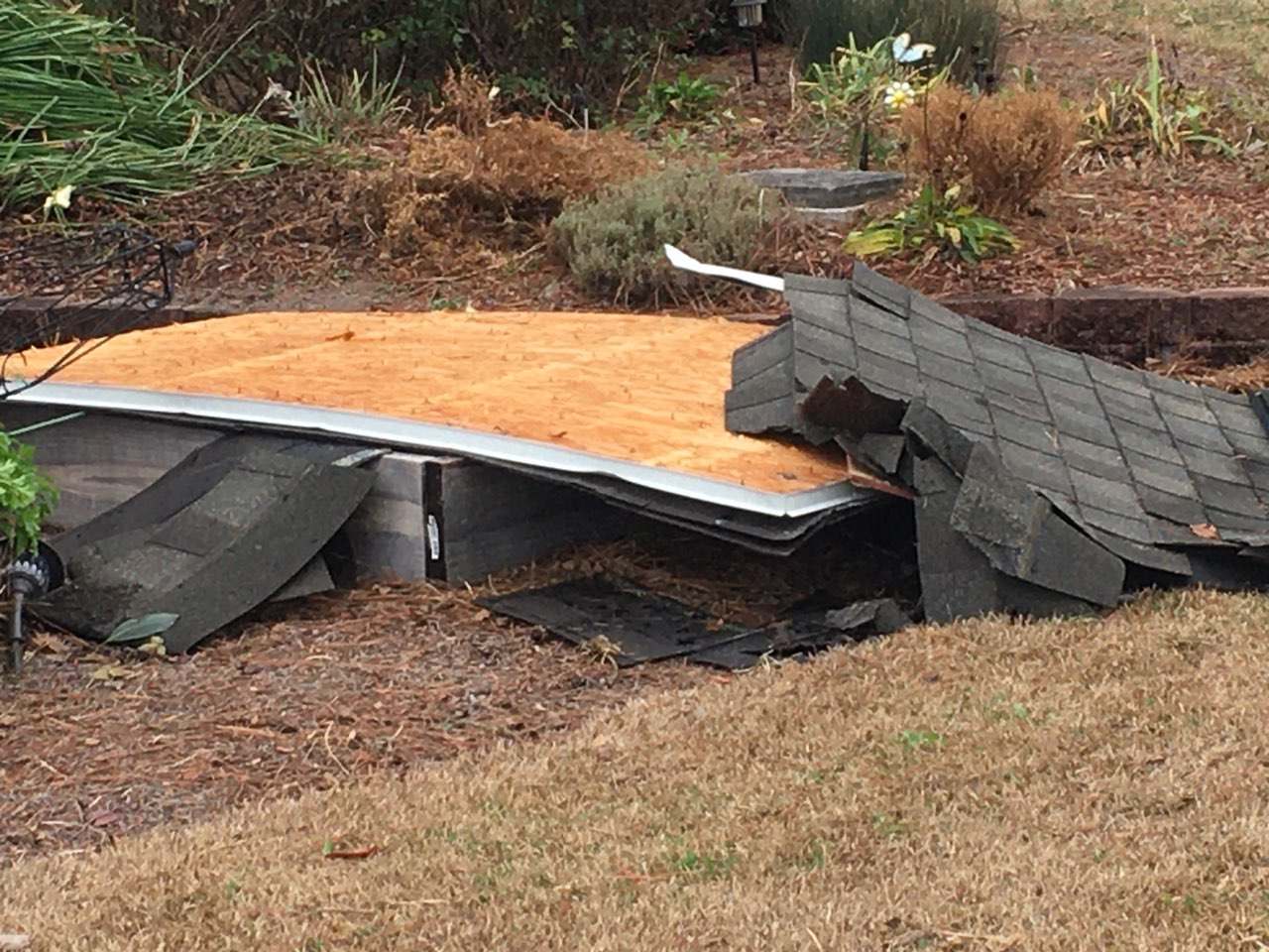
Several lines of thunderstorms moved across the area on Christmas Evening. With very strong winds just above the surface, these thunderstorms and heavier showers were able to create some very strong winds across parts of our area. Some damage was reported across Jones County near places such as Pollocksville and Phillips Crossroads.
Storm Reports (12/24/20 - 12/25/2020)
000
NWUS52 KMHX 262055
LSRMHX

PRELIMINARY LOCAL STORM REPORT...SUMMARY
NATIONAL WEATHER SERVICE NEWPORT/MOREHEAD CITY NC
355 PM EST SAT DEC 26 2020

..TIME...   ...EVENT...      ...CITY LOCATION...     ...LAT.LON...
..DATE...   ....MAG....      ..COUNTY LOCATION..ST.. ...SOURCE....
            ..REMARKS..

1046 PM     TSTM WND DMG     4 NNE PHILLIPS CROSSROA 35.13N 77.43W
12/24/2020                   JONES              NC   EMERGENCY MNGR

            JONES EM REPORTS CARPORT ON WYSE FORK RD
            SCATTERED AS FAR AS 300 YD FROM HOUSE.
            ADDITIONALLY LIGHT POLE NEAR PROPERTY WAS
            BROKEN AND HOME ACROSS THE STREET SUSTAINED
            DAMAGE. TIME ESTIMATED BY RADAR.


1108 PM     TSTM WND DMG     1 NE POLLOCKSVILLE      35.02N 77.20W
12/24/2020                   JONES              NC   PUBLIC

            ROOF BLOWN OFF HOUSE, PINE TREES DOWN,
            FENCING DOWN. EXTREMELY STRONG AND LOUD WIND
            GUST LASTING ROUGHLY 20-30 SECONDS.

1106 PM     TSTM WND DMG     2 SW POLLOCKSVILLE      34.99N 77.25W
12/24/2020                   JONES              NC   PUBLIC

            LIFTED SECTION OF ROOF OFF DOWN TO RAFTERS
            AND DROPPED IN YARD. TOOK DOWN SECTIONS OF
            TREATED WOOD FENCE, SNAPPING 2 POSTS.
            SNAPPED PINE TREE ACROSS STREET. MOVED HEAVY
            PATIO FURNITURE INCLUDING HEAVY FIRE PIT.


1205 AM     TSTM WND GST     1 E FRISCO              35.23N 75.62W
12/25/2020  M63 MPH          DARE               NC   ASOS

            HSE ASOS REPORTS GUST OF 55 KT.

0750 PM     MARINE TSTM WIND BUXTON                  35.26N 75.52W
12/24/2020  M45 MPH          DARE               NC   MESONET

            39 KNOT GUST MEASURED AT BUXTON
            WEATHERFLOW/HURRICANE STATION.

1140 PM     TSTM WND DMG     FAIRFIELD HARBOR        35.08N 76.97W
12/24/2020                   CRAVEN             NC   NWS EMPLOYEE

            LARGE TREE LIMB DOWN ON ROAD NEAR FAIRFIELD
            HARBOR.

0830 PM     NON-TSTM WND DMG 2 WSW WILDWOOD          34.73N 76.86W
12/24/2020                   CARTERET           NC   PUBLIC

            LARGE TREE FELL ONTO A BRICK RETAINING WALL
            AND INTO HWY 24.

0950 PM     MARINE TSTM WIND DIAMOND SHOALS BUOY     35.03N 75.36W
12/24/2020  M65 MPH          AMZ154             NC   BUOY

            DIAMOND SHOALS BUOY 41025 REPORTED A 56 KNOT
            MARINE THUNDERSTORM WIND GUST.

0824 PM     MARINE TSTM WIND HATTERAS FERRY TERMINAL 35.21N 75.70W
12/24/2020  M53 MPH          DARE               NC   OTHER FEDERAL

            NOS TIDE GAUGE AT THE U.S. COAST GUARD STATION IN
            HATTERAS REPORTED A 46 KNOT MARINE THUNDERSTORM WIND
            GUST.
|
Strong Winds
As we mentioned above, VERY strong winds will occurring on the afternoon of Christmas Eve into early Christmas morning. Sometimes, especially during the winter months, it can take a heavier shower or thunderstorm to bring these stronger winds to the surface. Other times warm water, such as near the Gulf Stream, can help bring stronger winds down to the waters. The graph below shows the Diamond Shoals Buoy gusted to 60 knots or 69 MPH (just shy of hurricane force (74 MPH) with waves up to 22 feet! The Diamond Shoals buoy is located less than 20 miles off from Cape Point on Hatteras Island.
Wind Speed Plot (Max 60 knots/69 MPH)
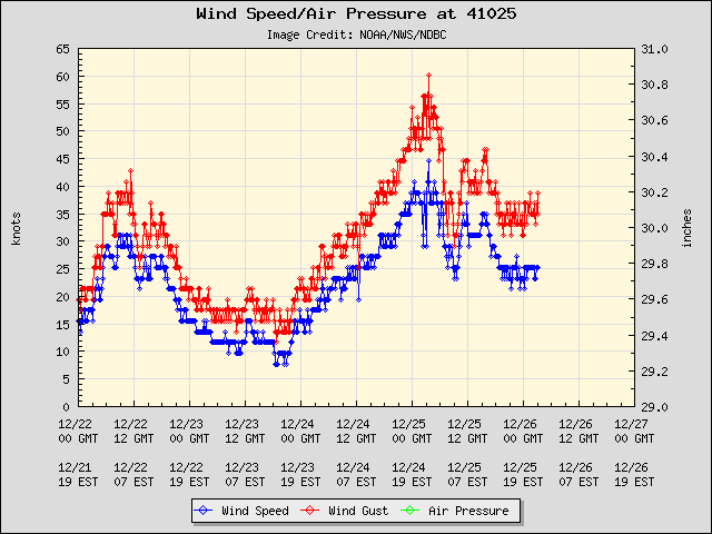
Max Wave Height Plot (Max 22 Feet)

A Sample Of High Wind Reports Across Our Area
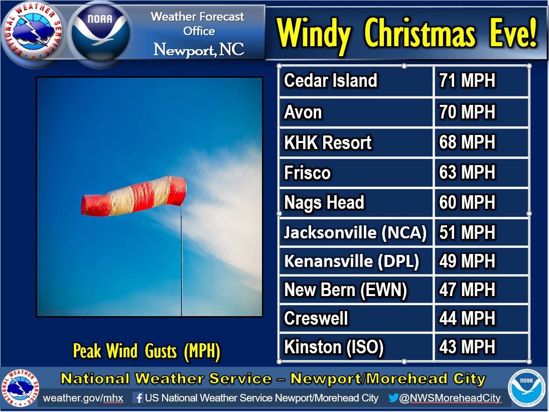
Detailed Wind Reports (12/24 to 12/25/2020)
000 NOUS42 KMHX 251600 PNSMHX NCZ029-044>047-079>081-090>092-094-193>196-198-199-203>205-260400- Public Information Statement...Corrected National Weather Service Newport/Morehead City NC 1100 AM EST Fri Dec 25 2020 ...HIGHEST WIND REPORTS... Location Speed Time/Date Provider ...North Carolina... ...Beaufort County... Washington (OCW AWOS) 43 MPH 1115 PM 12/24 AWOS Belhaven 37 MPH 1156 PM 12/24 CWOP Bunyan RAWS 36 MPH 0313 PM 12/24 RAWS Pamlico Aquaculture Field La 36 MPH 0700 PM 12/24 NC-ECONET ...Carteret County... 1 N Cedar Island 71 MPH 0647 PM 12/24 Mesonet Atlantic Beach 51 MPH 0530 PM 12/24 CWOP Fort Macon (WxFlow) 51 MPH 0626 PM 12/24 WXFLOW Bogue Field (NJM ASOS) 49 MPH 0757 PM 12/24 AWOS Indian Beach 49 MPH 0616 PM 12/24 CWOP Beaufort (MRH ASOS) 48 MPH 0858 PM 12/24 ASOS Cape Lookout 41 MPH 0600 PM 12/24 NDBC Newport 40 MPH 0951 PM 12/24 CWOP Cape Carteret 39 MPH 0801 PM 12/24 CWOP Morehead City 38 MPH 0715 PM 12/24 CWOP Cedar Island RAWS 37 MPH 0625 PM 12/24 RAWS Croatan RAWS 37 MPH 0705 PM 12/24 RAWS Newport 36 MPH 0623 PM 12/24 CWOP Emerald Isle 35 MPH 0746 PM 12/24 CWOP ...Craven County... New Bern (EWN ASOS) 47 MPH 1154 PM 12/24 ASOS Havelock 43 MPH 1150 PM 12/24 CWOP New Bern RAWS 36 MPH 1217 PM 12/24 RAWS Trent Woods 30 MPH 0212 PM 12/24 CWOP ...Dare County... Avon (WxFlow) 70 MPH 0734 PM 12/24 WXFLOW KHK Resort (WxFlow) 68 MPH 1134 PM 12/24 WXFLOW Frisco (HSE ASOS) 63 MPH 1205 AM 12/25 ASOS Nags Head 60 MPH 0905 PM 12/24 CWOP Rodanthe 58 MPH 1143 PM 12/24 CWOP Oregon Inlet CG (WxFlow) 57 MPH 1012 PM 12/24 WXFLOW Real Slick (WxFlow) 55 MPH 1128 PM 12/24 WXFLOW Dare Bomb Range RAWS 49 MPH 0828 PM 12/24 RAWS Kill Devil Hills 46 MPH 0748 PM 12/24 CWOP Manteo (MQI AWOS) 46 MPH 0735 PM 12/24 AWOS Hatteras High (WxFlow) 44 MPH 1210 AM 12/25 WXFLOW Frisco 43 MPH 1201 AM 12/25 CWOP Buxton 41 MPH 0900 PM 12/24 CWOP Dare Co Gnry Ran (2DP AWOS) 40 MPH 0656 PM 12/24 AWOS ...Duplin County... Kenansville (DPL AWOS) 49 MPH 0955 PM 12/24 AWOS Williamsdale Field Lab 35 MPH 0955 PM 12/24 NC-ECONET ...Hyde County... 4 NE Engelhard 48 MPH 0955 PM 12/24 AWOS ...Lenoir County... Cunningham Research Station 43 MPH 1030 PM 12/24 NC-ECONET Kinston (ISO AWOS) 43 MPH 1035 PM 12/24 AWOS ...Onslow County... Jacksonville (NCA ASOS) 51 MPH 1156 PM 12/24 AWOS Richlands (OAJ AWOS) 51 MPH 1056 PM 12/24 AWOS Sandy Run RAWS 38 MPH 0719 PM 12/24 RAWS Jacksonville 37 MPH 0628 PM 12/24 CWOP Hoffman RAWS 33 MPH 1210 PM 12/24 RAWS ...Pamlico County... Oriental 38 MPH 0639 PM 12/24 CWOP ...Pitt County... Dowdy Ficklen Stadium (WEATH 42 MPH 1050 PM 12/24 MESOWEST Greenville (PGV AWOS) 38 MPH 1055 PM 12/24 AWOS ...Washington County... Creswell 44 MPH 1200 AM 12/25 CWOP Roper 39 MPH 1215 PM 12/24 CWOP Pocosin Lakes RAWS 38 MPH 0717 PM 12/24 RAWS Tidewater Research Station 35 MPH 0720 PM 12/24 NC-ECONET ...Maritime Stations... 18 SE Cape Hatteras Lighthou 69 MPH 1030 PM 12/24 NDBC Frisco Woods (WxFlow) 65 MPH 1100 PM 12/24 WXFLOW Ocracoke (WxFlow) 64 MPH 0706 PM 12/24 WXFLOW Duck Pier 63 MPH 0948 PM 12/24 NOS-NWLON Avon Sound (WxFlow) 61 MPH 1126 PM 12/24 WXFLOW Alligator River Br (WxFlow) 60 MPH 0729 PM 12/24 WXFLOW Jennettes Pier (WxFlow) 59 MPH 0740 PM 12/24 WXFLOW Pamlico Sound (WxFlow) 57 MPH 0824 PM 12/24 WXFLOW 31 S Bogue Inlet Pier 54 MPH 0508 PM 12/24 NDBC North River 52 MPH 0619 PM 12/24 WXFLOW Croatan Sound 50 MPH 0745 PM 12/24 WXFLOW Beaufort 49 MPH 0624 PM 12/24 NOS-NWLON Roanoke Sound Channel (WxFlo 49 MPH 0754 PM 12/24 WXFLOW Oriental 38 MPH 0650 PM 12/24 CWOP |
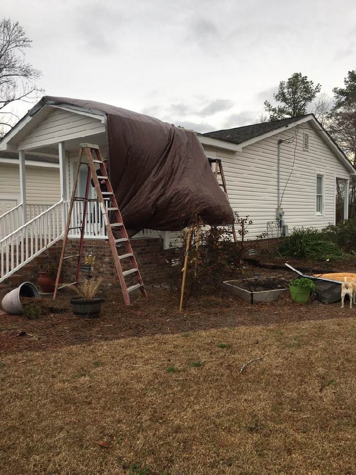
Pictures
Storm Damage Pictures (The strong wind occurred late Christmas Eve Around 11 PM)
|
Wyse Fork, NC Credit: WITN-TV |

Wyse Fork, NC Credit: WITN-TV |

Wyse Fork, NC Credit: WITN-TV |
|
Pollocksville, NC
Credit: Ivey Riggs |
Pollocksville, NC
Credit: Ivey Riggs |
Pollocksville, NC
Credit: Ivey Riggs |
Radar/Satellite
The radar loop below is from the afternoon of the 24th through mid morning on Christmas Day. Through the evolution of the radar you can see multiple lines of heavier rain and thunderstorms. Note, at the end of the loop the lighter echoes on the radar near Greenville, NC are scattered flurries. Below the radar loop is a IR Satellite Loop (GOES-16) from the same time period.
Morehead City, NC Radar (KMHX)
GOES-16 IR Satellite Loop
Low Temperatures
Behind the wind, severe storms and rain, much colder air filtered into our area behind a cold front Christmas Day. Lingering moisture and cold combined to produce a few flurries in place like Greenville and Nags Head. Temperatures held mainly in the 30s or lower 40s Christmas Day, and with the wind it felt more like the 20s at times. Eventually the wind died down, and that allowed temperatures to fall by the morning of the 26th. Many places away from the water fell into the lower to middle 20s. See a summary below.
Minimum Temperature Reports (12/26/20)
000 NOUS42 KMHX 262106 PNSMHX NCZ029-044>047-079>081-090>092-094-193>196-198-199-203>205-270905- Public Information Statement National Weather Service Newport/Morehead City NC 405 PM EST Sat Dec 26 2020 ...LOW TEMPERATURE REPORTS PAST 24 HOURS... Location Temp Time/Date Provider ...North Carolina... ...Beaufort County... Bunyan RAWS 24 F 0613 AM 12/26 RAWS Belhaven 25 F 0735 AM 12/26 CWOP Washington (OCW AWOS) 25 F 0715 AM 12/26 AWOS Aurora 27 F 0816 AM 12/26 CWOP Pamlico Aquaculture Field La 27 F 0800 AM 12/26 NC-ECONET Bunyan RAWS 31 F 0913 PM 12/25 RAWS ...Carteret County... Newport 21 F 0701 AM 12/26 CWOP Newport 23 F 0746 AM 12/26 CWOP 0.2 SW Newport 24 F 0747 AM 12/26 CWOP 1 ESE Morehead City 25 F 0801 AM 12/26 AWS Cape Carteret 25 F 0715 AM 12/26 CWOP Bogue Field (NJM ASOS) 26 F 1257 PM 12/26 AWOS Newport 26 F 0736 AM 12/26 CWOP Morehead City 26 F 0730 AM 12/26 CWOP Emerald Isle 27 F 0842 AM 12/26 CWOP Atlantic Beach 27 F 0715 AM 12/26 CWOP Newport 27 F 1001 PM 12/25 CWOP Fort Macon (WxFlow) 28 F 0826 AM 12/26 WXFLOW Beaufort 28 F 0715 AM 12/26 AWS Cedar Island RAWS 28 F 0625 AM 12/26 RAWS Beaufort (MRH ASOS) 29 F 1258 PM 12/26 ASOS Newport 30 F 0916 PM 12/25 CWOP Cape Lookout 31 F 0800 AM 12/26 NDBC Morehead City 32 F 0915 PM 12/25 CWOP ...Craven County... Geneseo 22 F 0802 AM 12/26 CWOP New Bern RAWS 23 F 0717 AM 12/26 RAWS 1 SSW James City 24 F 0735 AM 12/26 AWS New Bern (EWN ASOS) 25 F 1254 PM 12/26 ASOS Havelock 25 F 0741 AM 12/26 CWOP 3 S Havelock 25 F 0735 AM 12/26 AWS New Bern (EWN ASOS) 29 F 0954 PM 12/25 ASOS New Bern RAWS 29 F 0917 PM 12/25 RAWS ...Dare County... Dare Co Gnry Ran (2DP AWOS) 26 F 1256 PM 12/26 AWOS Kill Devil Hills 28 F 0724 AM 12/26 CWOP Nags Head 29 F 0756 AM 12/26 CWOP Manteo (MQI AWOS) 29 F 0755 AM 12/26 AWOS Real Slick (WxFlow) 31 F 1028 AM 12/26 WXFLOW Nags Head 31 F 0925 AM 12/26 AWS Buxton 31 F 0816 AM 12/26 CWOP Frisco (HSE ASOS) 32 F 1251 PM 12/26 ASOS Avon (WxFlow) 32 F 1009 AM 12/26 WXFLOW Hatteras High (WxFlow) 32 F 0934 AM 12/26 WXFLOW ...Hyde County... 4 NE Engelhard 25 F 0715 AM 12/26 AWOS Fairfield RAWS 31 F 0917 PM 12/25 RAWS ...Lenoir County... Cunningham Research Station 24 F 0740 AM 12/26 NC-ECONET Cunningham Research Station 30 F 0950 PM 12/25 NC-ECONET ...Martin County... Highway Patrol Comm Station 28 F 0945 PM 12/25 NC-ECONET ...Onslow County... Richlands (OAJ AWOS) 19 F 0656 AM 12/26 AWOS Jacksonville 19 F 0619 AM 12/26 CWOP Jacksonville 7.0 W 21 F 0721 AM 12/26 CWOP Hoffman RAWS 21 F 0710 AM 12/26 RAWS Sandy Run RAWS 22 F 0719 AM 12/26 RAWS Jacksonville 22 F 0534 AM 12/26 CWOP Hoffman RAWS 27 F 0910 PM 12/25 RAWS Richlands (OAJ AWOS) 29 F 0956 PM 12/25 AWOS Sandy Run RAWS 29 F 0919 PM 12/25 RAWS Jacksonville 30 F 1011 PM 12/25 CWOP ...Pamlico County... Bayboro 25 F 0735 AM 12/26 AWS Oriental 27 F 0810 AM 12/26 CWOP Bayboro 31 F 1010 PM 12/25 AWS ...Pitt County... Greenville 24 F 0759 AM 12/26 CWOP Dowdy Ficklen Stadium (WEATH 26 F 0810 AM 12/26 MESOWEST Greenville (PGV AWOS) 27 F 0755 AM 12/26 AWOS Greenville (PGV AWOS) 30 F 0955 PM 12/25 AWOS 3 WNW Winterville 32 F 0650 PM 12/25 CWOP ...Washington County... Pocosin Lakes RAWS 22 F 0717 AM 12/26 RAWS Creswell 24 F 0746 AM 12/26 CWOP Tidewater Research Station 25 F 0555 AM 12/26 NC-ECONET Roper 28 F 0831 AM 12/26 CWOP Creswell 29 F 1000 PM 12/25 CWOP Tidewater Research Station 30 F 0940 PM 12/25 NC-ECONET Roper 32 F 1001 PM 12/25 CWOP ...Maritime Stations... Oriental 25 F 0745 AM 12/26 CWOP Duck Pier 28 F 0954 AM 12/26 NOS-NWLON Alligator River Br (WxFlow) 28 F 0739 AM 12/26 WXFLOW Oregon Inlet Marina 29 F 0806 AM 12/26 NOS-NWLON Beaufort 29 F 0836 AM 12/26 NOS-NWLON Jennettes Pier (WxFlow) 30 F 0930 AM 12/26 WXFLOW Pamlico Sound (WxFlow) 30 F 0957 AM 12/26 WXFLOW Avon Sound (WxFlow) 31 F 0956 AM 12/26 WXFLOW Roanoke Sound Channel (WxFlo 31 F 1049 AM 12/26 WXFLOW Croatan Sound 31 F 1043 AM 12/26 WXFLOW Ocracoke (WxFlow) 32 F 1041 AM 12/26 WXFLOW 18 SE Cape Hatteras Lighthou 36 F 1130 AM 12/26 NDBC 31 S Bogue Inlet Pier 36 F 1008 AM 12/26 NDBC |
Minimum Temperature Reports (12/27/20)
000 NOUS42 KMHX 272215 PNSMHX NCZ029-044>047-079>081-090>092-094-193>196-198-199-203>205-281001- Public Information Statement National Weather Service Newport/Morehead City NC 501 PM EST Sun Dec 27 2020 ...LOW TEMPERATURE REPORTS PAST 24 HOURS... Location Temp Time/Date Provider ...North Carolina... ...Beaufort County... Bunyan RAWS 24 F 0713 AM 12/27 RAWS Washington (OCW AWOS) 25 F 0715 AM 12/27 AWOS Aurora 26 F 0815 AM 12/27 CWOP Belhaven 28 F 0717 AM 12/27 CWOP Pamlico Aquaculture Field La 29 F 0725 AM 12/27 NC-ECONET ...Carteret County... Cape Carteret 1.5 NE 22 F 0635 AM 12/27 NWS Employee 0.2 SW Newport 24 F 0701 AM 12/27 CWOP Newport 24 F 0615 AM 12/27 NWS Office Newport 24 F 0600 AM 12/27 CWOP Cape Carteret 25 F 0730 AM 12/27 CWOP Croatan RAWS 25 F 0505 AM 12/27 RAWS Newport 27 F 0316 AM 12/27 CWOP Bogue Field (NJM ASOS) 27 F 1257 PM 12/27 AWOS Newport 28 F 0331 AM 12/27 CWOP Cedar Island RAWS 29 F 0725 AM 12/27 RAWS Newport 30 F 0719 AM 12/27 CWOP Morehead City 30 F 0345 AM 12/27 CWOP Emerald Isle 32 F 0640 AM 12/27 CWOP Beaufort (MRH ASOS) 32 F 1258 PM 12/27 ASOS 1 ESE Morehead City 32 F 1109 AM 12/27 AWS Beaufort 33 F 0755 AM 12/27 AWS Indian Beach 33 F 0631 AM 12/27 CWOP Atlantic Beach 33 F 0245 AM 12/27 CWOP Fort Macon (WxFlow) 35 F 0206 AM 12/27 WXFLOW Cape Lookout 39 F 0600 AM 12/27 NDBC ...Craven County... Geneseo 23 F 0802 AM 12/27 CWOP New Bern (EWN ASOS) 24 F 1254 PM 12/27 ASOS New Bern RAWS 24 F 0717 AM 12/27 RAWS 3 S Havelock 25 F 0740 AM 12/27 AWS Cherry Point (NKT ASOS) 25 F 1254 PM 12/27 AWOS 1 SSW James City 26 F 0755 AM 12/27 AWS Havelock 27 F 0750 AM 12/27 CWOP ...Dare County... Dare Co Gnry Ran (2DP AWOS) 25 F 0656 AM 12/27 AWOS Dare Bomb Range RAWS 25 F 0628 AM 12/27 RAWS Manteo (MQI AWOS) 29 F 0735 AM 12/27 AWOS Nags Head 33 F 0607 AM 12/27 CWOP Nags Head 35 F 0150 AM 12/27 AWS Kill Devil Hills 35 F 0736 AM 12/27 CWOP Buxton 36 F 0845 PM 12/26 CWOP Oregon Inlet (WxFlow) 36 F 0658 AM 12/27 WXFLOW Buxton (WxFlow) 37 F 0750 PM 12/26 WXFLOW Frisco (HSE ASOS) 38 F 0551 PM 12/26 ASOS Hatteras High (WxFlow) 38 F 0524 PM 12/26 WXFLOW Oregon Inlet CG (WxFlow) 38 F 0652 AM 12/27 WXFLOW Avon (WxFlow) 39 F 0539 PM 12/26 WXFLOW Real Slick (WxFlow) 39 F 1038 PM 12/26 WXFLOW Rodanthe 42 F 0808 AM 12/27 CWOP ...Duplin County... Kenansville (DPL AWOS) 21 F 0735 AM 12/27 AWOS Williamsdale Field Lab 23 F 0750 AM 12/27 NC-ECONET ...Hyde County... 4 NE Engelhard 26 F 0735 AM 12/27 AWOS Fairfield RAWS 27 F 0717 AM 12/27 RAWS ...Lenoir County... Kinston (ISO AWOS) 24 F 0455 AM 12/27 AWOS Cunningham Research Station 26 F 0740 AM 12/27 NC-ECONET ...Martin County... Highway Patrol Comm Station 23 F 0700 AM 12/27 NC-ECONET ...Onslow County... Jacksonville 7.0 W 22 F 0711 AM 12/27 CWOP Jacksonville 22 F 0749 AM 12/27 CWOP Hoffman RAWS 22 F 0710 AM 12/27 RAWS Richlands (OAJ AWOS) 22 F 1256 PM 12/27 AWOS Sandy Run RAWS 23 F 0719 AM 12/27 RAWS Jacksonville 23 F 0713 AM 12/27 CWOP Jacksonville (NCA ASOS) 25 F 1256 PM 12/27 AWOS Sneads Ferry 29 F 0800 AM 12/27 CWOP ...Pamlico County... Bayboro 26 F 0740 AM 12/27 AWS Oriental 29 F 0718 AM 12/27 CWOP ...Pitt County... 3 WNW Winterville 24 F 0810 AM 12/27 CWOP Greenville 24 F 0746 AM 12/27 CWOP Greenville (PGV AWOS) 25 F 0635 AM 12/27 AWOS Dowdy Ficklen Stadium (WEATH 29 F 0750 AM 12/27 MESOWEST ...Washington County... Pocosin Lakes RAWS 20 F 0717 AM 12/27 RAWS Tidewater Research Station 24 F 0720 AM 12/27 NC-ECONET Creswell 25 F 0731 AM 12/27 CWOP Roper 28 F 0601 AM 12/27 CWOP ...Maritime Stations... Oriental 26 F 0745 AM 12/27 CWOP North River 28 F 0329 AM 12/27 WXFLOW Alligator River Br (WxFlow) 34 F 0539 AM 12/27 WXFLOW Beaufort 35 F 0736 AM 12/27 NOS-NWLON Oregon Inlet Marina 36 F 0718 AM 12/27 NOS-NWLON Duck Pier 37 F 0848 AM 12/27 NOS-NWLON Jennettes Pier (WxFlow) 37 F 0215 AM 12/27 WXFLOW Roanoke Sound Channel (WxFlo 37 F 0159 AM 12/27 WXFLOW Croatan Sound 38 F 0723 AM 12/27 WXFLOW Avon Sound (WxFlow) 39 F 0441 PM 12/26 WXFLOW Pamlico Sound (WxFlow) 39 F 1032 PM 12/26 WXFLOW Ocracoke (WxFlow) 40 F 0541 PM 12/26 WXFLOW 18 SE Cape Hatteras Lighthou 42 F 0430 PM 12/26 NDBC 31 S Bogue Inlet Pier 44 F 0508 PM 12/26 NDBC && Observations are collected from a variety of sources with varying equipment and exposures. We thank all volunteer weather observers for their dedication. Not all data listed are considered official. |


.png) Surf Forecast/Rip Currents
Surf Forecast/Rip Currents Tropical Weather
 Map View
 Weather Hazard Briefing (when applicable)
 Forecaster Discussion
 Marine
 Text Products
.png) Skywarn
Skywarn Submit Storm Reports