
A localized outbreak of tornadoes and large hail occurred over portions of the NWS Austin/San Antonio County Warning Area (CWA) during the afternoon and evening hours of March 21, 2022. Over the span of several hours, six tornadoes tracked across portions of South-Central Texas, accompanied by numerous reports of large hail. This recap takes a closer look at the severe weather—particularly the tornadoes—that occurred on the afternoon of March 21.

A link to these severe weather reports can be found here.

Additional information for each tornado on this map can be found using the tabs above.
In the several days leading up to the event, confidence began to increase that potentially widespread severe weather would occur on the afternoon of March 21. A potent early spring setup appeared likely to come together across the area, with a strong upper level disturbance forecast to overspread a moist and unstable air mass near the surface. Such a superposition of ingredients lended itself particularly well to turning winds with height, with strong southwesterly upper level winds gliding over brisk southerly winds at ground level. Conditions appeared ripe for rotating thunderstorms capable of producing large hail and potentially strong tornadoes. The Storm Prediction Center (SPC) began highlighting portions of the area in an Enhanced (level 3/5) Risk for severe weather as early as the morning of Saturday, March 19—more than forty eight hours prior to the first storm forming—in light of this potential. With the forecast still largely on track on the morning of Monday, March 21, SPC upgraded northeastern areas of the CWA to a Moderate (level 4/5) Risk for severe weather. This marked the first time in nearly six calendar years that the Austin/San Antonio CWA was included in a Moderate Risk. With thunderstorm formation imminent, a tornado watch was issued for areas east of US 281 at 3:10 PM CDT.


Forming ahead of an advancing surface dryline, thunderstorms rapidly began to form along the US 281 corridor to the north of San Antonio between 3:30 and 4:30 PM CDT on the afternoon of March 21. Light returns on radar, focused initially over portions of Gillespie and Kendall Counties, quickly blossomed into a broken line of strong thunderstorms extending from the Burnet-Llano County line south to very near the San Antonio International Airport. The rapid growth exhibited by the storms translated to a growing number of hail reports, prompting issuance of the first severe thunderstorm warning of the afternoon for portions of Blanco, Burnet, Hays, and Travis Counties at 4:20 PM CDT. Upward trends in hail production continued over the following thirty minutes, with two additional severe thunderstorm warnings being issued for cells south of the first warning. By 5:00 PM CDT, severe thunderstorm warnings extended from the Travis-Burnet County line south into Guadalupe and far eastern Bexar Counties as the broken line of storms quickly approached the I-35 corridor.

Despite their rapid growth and hail production, storms struggled to establish coherent mid and low level rotation over the first ninety minutes of the outbreak. A critical component of tornado production in severe thunderstorms, this led to an absence of tornado warnings across South-Central Texas during the opening stages of this event. This changed between 5 and 5:30 PM CDT, as storms progressed into an environment far more conducive for tornadoes along and east of Interstate 35. Signs of rotation and a potential tornado became apparent along the Comal-Hays County line, leading to the first tornado warning of the day being issued at 5:20 PM CDT for portions of central Hays County. A region of doppler radar-indicated rotation around Wimberley would be surveyed following the event, though it would be concluded that no tornadoes touched down in the area. Several more storms would begin to rotate and eventually drop tornadoes following the Hays County tornado warning, and are discussed in the remaining separate sections at the top of this event review.

Click here to download the KMZ file showing the complete damage survey, including photos.

Animation of radar reflectivity (left) and azimuthal velocity data (right) during the Kingsbury/Stairtown tornado. In the velocity image at right, shades of green indicate wind blowing toward the EWX radar in New Braunfels. Red shades indicate winds blowing away. Where the two come together and wrap around one another, strong rotation is occurring.
The first of the event, the Kingsbury-Stairtown tornado was produced by the southernmost supercell of the broken complex that impacted the I-35 corridor during the afternoon and evening of March 21. Showing signs of rotation as it tracked east along Interstate 10 toward Seguin, a tornado warning was issued for the storm at 5:24 PM CDT. Continuing to parallel and eventually cross to the north of the freeway, an uptick in low level rotation occurred over the following twenty minutes, with a tornado touching down immediately to the east of Kingsbury at 5:48 PM. Tracking east-northeast toward the Guadalupe-Caldwell County line, the tornado inflicted substantial damage to trees, as well as varying degrees of structural damage to homes and barns. Debris became apparent in our radar’s correlation coefficient display between 5:50 and 6:00 PM as these impacts were occurring. The tornado turned hard to the left as it crossed into Caldwell County, damaging another residence, toppling numerous trees, and throwing an ATV. Rapidly dissipating thereafter, the tornado lifted along FM 671 to the northeast of Stairtown at 6:08 PM CDT. Maximum damage was assessed at EF2 intensity on the Enhanced Fujita Scale.

Still of radar reflectivity (left) and correlation coefficient (right) from the EWX radar at 5:55 PM CDT. The circular area in blue present in the correlation coefficient display (circled in white) indicates the presence of debris as the tornado is crossing US 90 between Kingsbury and Luling, and is referred to as a tornado debris signature (TDS).

Click here to download the KMZ file showing the complete damage survey, including photos.

Animation of reflectivity (top, left) storm relative velocity (top, right) correlation coefficient (bottom, left) and differential reflectivity (bottom, right) during the Jarrell tornado as sampled from the Granger (GRK) radar in Williamson County. Note the strong rotational signal implied in the velocity data as the storm cell nears the southwest side of Jarrell.
Just three minutes after the birth of the Kingsbury tornado, the Jarrell tornado formed following the swift development of low level rotation in its parent thunderstorm. Touching down on the southwest side of town, the tornado inflicted minor damage to trees and outbuildings during the preliminary stages of its life. Parallelling Interstate 35 as it trekked northeast, the storm entered its most intense phase after passing the intersection of FM 487 and CR 305. Several travel trailers were either heavily damaged or destroyed, and several homes suffered substantial roof damage. With winds reaching an estimated 100 miles per hour, the tornado was deemed to be at EF1 strength as it moved through this area. Nearing and eventually crossing the Williamson-Bell County line, the twister began to weaken as it produced minor tree and fence damage. The last observable damage was noted near Prairie Dell Church Road in far southern Bell County, where it was concluded that the tornado lifted at 6:13 PM CDT.

Click here to download the KMZ file showing the complete damage survey, including photos.

Animation of reflectivity (top, left) storm relative velocity (top, right) correlation coefficient (bottom, left) and differential reflectivity (bottom, right) as a tornado developed near Round Rock, then moved northeast to near Granger.
With a path spanning twenty-nine miles across portions of Travis and Williamson Counties, the Round Rock/Granger tornado was the longest lived twister of the March 21 event. Touching down just to the southwest of the I-35/TX 45 interchange in Round Rock, the tornado quickly intensified to EF1 strength, snapping trees and damaging roofs in a residential area to the west of Interstate 35. The storm would maintain EF1 strength as it crossed the freeway, tracking over the Boardwalk shopping center and inflicting damage to roofs and windows of businesses. Progressing into the Windy Terrace and Greenlawn Place neighborhoods, the tornado briefly strengthened to EF2 levels, tearing the roofs off of several residences. Like the Kingsbury tornado, a tornado debris signature was apparent to the east of Interstate 35 as these events transpired. Weakening to high EF1 intensity, the tornado continued in a largely northeast direction as it traveled over the South Creek neighborhood and approached US 79. Prior to crossing the highway, the twister impacted portions of the Kalahari Resorts Texas property, damaging vehicles in the hotel’s parking lot and blowing out windows. Exiting Round Rock and eventually crossing the San Gabriel River, the tornado strengthened back to EF2 levels, imparting substantial structural damage to several homes between CR337 and the CR346-CR347 intersection in northeastern Williamson County. Again dropping to EF1 intensity, the tornado would snap additional trees and power poles as it narrowly missed the Granger (GRK) radar site, cutting its power supply for approximately two hours. The twister continued into Bell County and the Fort Worth County Warning Area shortly thereafter.

Last reflectivity (left) and storm relative velocity (right) scans, taken at 6:19 PM CDT, prior to the Granger radar going down. Well-defined rotation, pointing to the presence of the tornado, is apparent just to the southwest of the radar site.
Click here to download the KMZ file showing the complete damage survey, including photos.

Animation of reflectivity (top, left) storm relative velocity (top, right) correlation coefficient (bottom, left) and differential reflectivity (bottom, right) during the Elgin tornado as sampled from the New Braunfels (EWX) radar. Williamson County. Note the lowering of the correlation coefficient (evidence of tornado debris) from just east of the Travis and Bastrop county line to the south side of Jarrell.
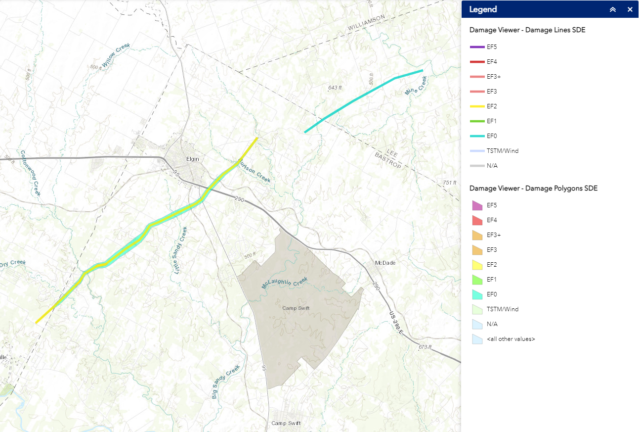
Touching down just west of the Bastrop-Travis County line between the communities of Littig and Webberville, the Elgin tornado produced the most significant damage at the beginning of its life. Tracking north-northeast to the west of FM 1704, the tornado destroyed multiple mobile homes, in addition to inflicting heavy damage to roofs and second stories of site-built houses. What were at times high-end EF2 winds also snapped numerous trees and power poles, and toppled a high-voltage electrical transmission tower. The tornado’s winds weakened to EF1 levels as it crossed FM 1704 and TX 95, causing additional damage to mobile homes, trees, and power poles. Intensification occurred as the storm neared US 290, with high-end EF1 to low-end EF2 damage being noted at a pair of metal-framed businesses. Crossing the highway, the tornado rolled and subsequently spun a pickup truck 360 degrees, bringing the vehicle to rest in its initial upright position. Documented in video footage, this was a moment that grabbed national headlines. Shifting north and east of US 290, the tornado destroyed another mobile home at EF2 intensity, prior to dissipating and lifting approximately three miles to the northeast of Elgin. In all, damage was documented at over one hundred structures along the tornado’s twelve mile path. Twenty-one of said structures were deemed to be completely destroyed.
Additional data from spotter reports, the Texas Department of Emergency Management, the Texas Department of Public Safety and radar data from the Texas A&M Aggie Doppler Radar (ADRAD) confirmed a second tornado during this event. The tornado touched down in far northeast Bastrop county just east of the intersection of North County Line Road and Old Lexington Road around 6:54 PM. The tornado then moved into the far western portion of Lee county where it dissipated around 7:04 PM just before reaching the Middle Yegua Creek. This tornado has been rated as an EF-0.

Animation of reflectivity during the second Elgin tornado as sampled from Aggie Doppler Radar (ADRAD)

Click here to download the KMZ file showing the complete damage survey, including photos.

Animation of reflectivity (top, left) storm relative velocity (top, right) correlation coefficient (bottom, left) and differential reflectivity (bottom, right) during the Elgin tornado as sampled from the New Braunfels (EWX) radar.
The final tornado of the March 21 event, the Giddings tornado stemmed from the same supercell that produced the Kingsbury twister. Touching down immediately to the west of FM448, the tornado caused varying degrees of roof damage to metal outbuildings south and west of downtown Giddings. Similar damage occurred as the twister crossed FM448 and the southern portions of Giddings proper. Turning east and crossing US 77, a fence was blown over by the tornado along Whispering Oaks Drive. After bending a cross on the steeple of the First Baptist Church, the tornado dissipated following just four minutes on the ground. Damage assessments concluded that the Giddings tornado had maximum winds of 95 MPH, making it an EF1 tornado on the Enhanced Fujita Scale.

Animation of reflectivity during the Giddings tornado as sampled from Aggie Doppler Radar (ADRAD)


 Follow us on YouTube