Overview (Work in Progress) :)
|
Summary of the storm that occurred in the early evening on July 14th, 2020: A series of high-based storms traveling over the eastern plains came into contact with moist air flowing in from the east. The storms lowered and merged into a convective line, which allowed for the formation of some low-level rotation around 6:50 PM. By 6:59 PM, a tornado warning had been issued by NWS Pueblo. The tornado was reported by 3 storm spotters, and touched down in a mostly empty field west of Las Animas around 7:01 PM. Very few witnesses were in the area, but based on the spotter reports available, the tornado was on the ground for approximately 10 minutes and traveled less than 2 miles through the field before lifting and dissipating. Luckily, there was no reported damage, injuries or fatalities, so a storm survey was not necessary. Unfortunately, this means an EF rating was not determined. |
 Rotation below a storm near Ordway, Colorado. Courtesy of Rob Hoff on Twitter. |
Tornado:
|
Tornado - Las Animas, CO
Est. Track Map 
|
||||||||||||||||
Photos & Video
Header
(source) |
 |
| From Chad Casey on Twitter | From Emily Roehler and Jill Huserman on Twitter |
 |
 |
| Visible/IR Satellite | Visible Satellite |
Radar
Radar Imagery of the Convective Line that Produced the Tornado
 |
 |
 |
 |
| KPUX 00:54 UTC | KPUX 01:01 UTC | KPUX 01:08 UTC | KPUX 01:11 UTC |
Storm Reports
PRELIMINARY LOCAL STORM REPORT...SUMMARY
NATIONAL WEATHER SERVICE PUEBLO CO
933 PM MDT TUE JUL 14 2020
..TIME... ...EVENT... ...CITY LOCATION... ...LAT.LON...
..DATE... ....MAG.... ..COUNTY LOCATION..ST.. ...SOURCE....
..REMARKS..
0415 PM HAIL YODER 38.84N 104.22W
07/14/2020 M1.75 INCH EL PASO CO PUBLIC
RELAYED VIA MEDIA.
0400 PM HAIL 1 NNW RUSH 38.85N 104.09W
07/14/2020 M1.50 INCH EL PASO CO PUBLIC
SOCIAL MEDIA POST.
0704 PM TORNADO 1 SW LAS ANIMAS 38.06N 103.23W
07/14/2020 BENT CO PUBLIC
REPORTED VIA SOCIAL MEDIA.
0700 PM TORNADO 6 W LAS ANIMAS 38.08N 103.34W
07/14/2020 BENT CO PUBLIC
TIME ESTIMATED. TOUCHED DOWN IN SOUTH FIELD.
0700 PM TORNADO 3 SW LAS ANIMAS 38.03N 103.26W
07/14/2020 BENT CO TRAINED SPOTTER
TORNADO TOUCH DOWN.
0700 PM TORNADO 4 W LAS ANIMAS 38.06N 103.30W
07/14/2020 BENT CO PUBLIC
LOCATION APPROXIMATED.
0817 PM TSTM WND GST 9 S SPRINGFIELD 37.28N 102.62W
07/14/2020 M61 MPH BACA CO ASOS
ASOS STATION KSPD 8 S SPRINGFIELD.
Environment
Starting in the early morning hours, the area of interest was sandwiched between an upper-level trough along the Canadian border and a ridge centered over southwest Texas, visible at 300 mb. A weak disturbance, evident at 700 mb, had developed over central Colorado, which will allow for a source of positive vorticity advection and assist in providing atmospheric lift later in the day. A stationary front was also positioned in northern Colorado stretching into northern Nebraska. Throughout the day, the trough progressed slowly eastward and began moving the stationary front to the south and west as it transitioned to a cold front. The temperature gradient across the front was fairly weak, but the most important aspect of this front later becomes the shift in wind direction. This shift allowed for an influx of more moist air in addition to providing the necessary shear to develop more well-sustained updrafts in thunderstorms.
By midday, the front had begun slowly meandering its way southwards, while dry conditions prevailed over the eastern plains. Given the large disparities between temperatures and dew points, combined with impressive low to mid-level lapse rates in model soundings, the morning forecasters predicted the main threats for the day would be severe winds and large hail. Isolated, high-based thunderstorms were expected to develop in the afternoon and slowly merge into a convective line by evening before moving east into Kansas. As the front began to move southward, the winds changed to an easterly flow, bringing in more moist air and causing dew point temperatures to soar into the 60s, supplying much better moisture and increasing instability greatly (CAPE was forecasted to increase to around 2000 J/kg, more than enough for strong updrafts and large hail in this environment).
By about 6:30 pm, storm bases had lowered considerably due to the increase in near-surface moisture behind the passing cold front, which had now more or less stalled out again over the mountains. The bulk shear was over 40 knots at this point, and many of the more isolated cells had begun to merge into a more linear structure as the convection in the region became more outflow dominant and the system moved into an area with 3000+ surface CAPE. As the storms merged, their outflow and internal updrafts resulted in small pockets of rotation near the front of the line, and several tornado warnings had been issued in Otero, Bent, Kiowa, and Crowley counties. A tornado warning for this particular part of the storm was published at 6:59 pm. At approximately 7:01 pm, the tornado was reported to be on the ground, staying down for approximately 15-20 minutes and traveling several miles before dissipating.
SPC Upper-Air Maps:
July 14th, 2020 at 6:00AM MDT
 |
 |
 |
| 300-hPa Analysis | 500-hPa Analysis | 700-hPa Analysis |
 |
 |
| 850-hPa Analysis | Surface Analysis |
July 14th, 2020 at 6:00PM MDT
 |
 |
 |
| 300-hPa Analysis | 500-hPa Analysis | 700-hPa Analysis |
 |
 |
| 850-hPa Analysis | Surface Analysis |
Forecast Soundings:
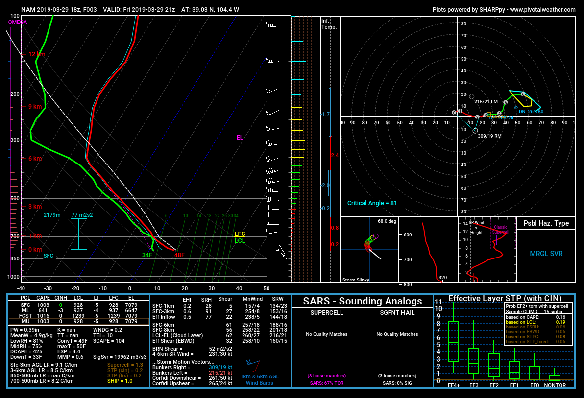 |
| March 29, 2019 18Z NAM, 3 hour forecast valid at 21Z, or 3 PM, near location of tornado. |
SPC Mesoanalysis:
 |
 |
 |
| Surface Observations | Surface-based CAPE, CIN | LCL Heights |
 |
 |
 |
| 0-1 km Wind Shear | Effective Bulk Shear |
Effective Storm Relative Helicity |
 |
 |
 |
| Low-Level Lapse Rates | Mid-Level Lapse Rates | Low-Level Storm-Relative Winds |
 |
Media use of NWS Web News Stories is encouraged! Please acknowledge the NWS as the source of any news information accessed from this site. |
|

