
Moisture across the northern Plains, upper Great Lakes into northern New England will likely bring a period of snow, sleet and freezing rain through this weekend. Meanwhile, heavy rainfall continues along the Gulf Coast with areas of flooding. Fire weather conditions continue for the areas of the Plains, southern Appalachians into portions of Florida. Severe thunderstorm potential increasing. Read More >
 |
 |
| Overview of the Severe Thunderstorm Warnings Issued Throughout the Event | Overview of the Severe Thunderstorm Warnings Issued Throughout the Event |
 |
| Satellite View of the Prolific Hail Event |
Overview
The general synoptic set-up shows that the day was going to be a monsoonal thunderstorm day. A high pressure system was centered over the desert southwest of the U.S. The low-level flow was from the southeast, advecting moisture from the Gulf of America towards southern Colorado. Generally speaking, during a monsoonal pattern like this, the upper-level winds tend to be weak, but during the August 6th, 2018 event, there were anomalously strong winds aloft, creating higher wind shear magnitudes, as analyzed in the mesoanalysis images, located underneath the “Environment” tab. The surface dew point temperatures were 58°F accompanied by a weak 5 knot southeasterly wind. Before convective initiation at 12:00 PM MDT across El Paso County was around 2000 J/kg (Fig. 9) with effective bulk wind shear value of 45–50 kts (Fig. 5), which are values high enough to produce substantial severe weather. To further dive in to the thermodynamics of the afternoon, the lifted index (LI) was -7, the mid-level lapse rates were around 8.5° C/km (Fig. 6), which is common for the lee of the Rocky Mountains, the low-level lapse rates were around 7.5°C/km (Fig. 7), lifted condesation levels (LCL) were 1250–1500 m AGL (Fig. 8), and there was a theta-e “tongue”, with values of around 354 Kelvin (Fig 10), reaching all the way up the point of where convective initiation occurred, as well as calculated theta-e advection against the lee of the Rocky Mountains. As for the lifting mechanism that sparked the thunderstorm in Park County, the overall dynamics were weak, but the 700hPa analysis (Fig. 2) illustrates a shortwave trough propagating over the region, 700hPa frontogenesis charts (Fig. 3) illustrates a magnitude maximum located over Park County, which is likely due to orographic effects, and the 300hPa jet circulation chart (Fig. 4) indicated a region of divergence over Park County.
Storm Evolution:
The storm initiation occurred over eastern Park County, quickly developing in to Teller County and becoming severe. The first Severe Thunderstorm Warning (for the supercell in discussion) was issued at 1:19PM MDT, followed by the second Severe Thunderstorm Warning at 1:45PM MDT. The first local storm report (LSR) was 2.75 inch hail at 1400 LDT, 3 miles south of Colorado Springs. At that point the thunderstorm had been warned for 41 minutes. At that point, the upper level divergence values, via the KPUX radar, were around 144 kts, which according to literature, corresponds to 2.00”–2.50 ” hail. MESH was in agreement, estimating hails size around 2.63”. The storm moved over Cheyenne Mountain Zoo at around 2:20PM MDT, at which the storm had been warned on for 1 hour. Upper level divergence values were again around 143 kts, which corresponds to 2.00–2.50” hail. LSRs confirm that hail stones were around 2.75” in diameter once more. The supercell continued to propagate southeasterly, eventually over Fountain, CO, in which 2.5” diameter hail was observed. A large hail spike was observed, starting at 3:14PM, during that time there was 3.0” diameter hail located around north of the Pueblo / El Paso County line.
Warning Statistics (12PM - 6PM):
False Alarm Ratio = 0.27
Probability of Detection = 0.88
Threat Score = 0.66
Average Lead Time = 25.5 Mintutes
Max Lead Time = 45.0 Minutes
Min Lead Time = 0.0 Minutes
Hail:
Hail
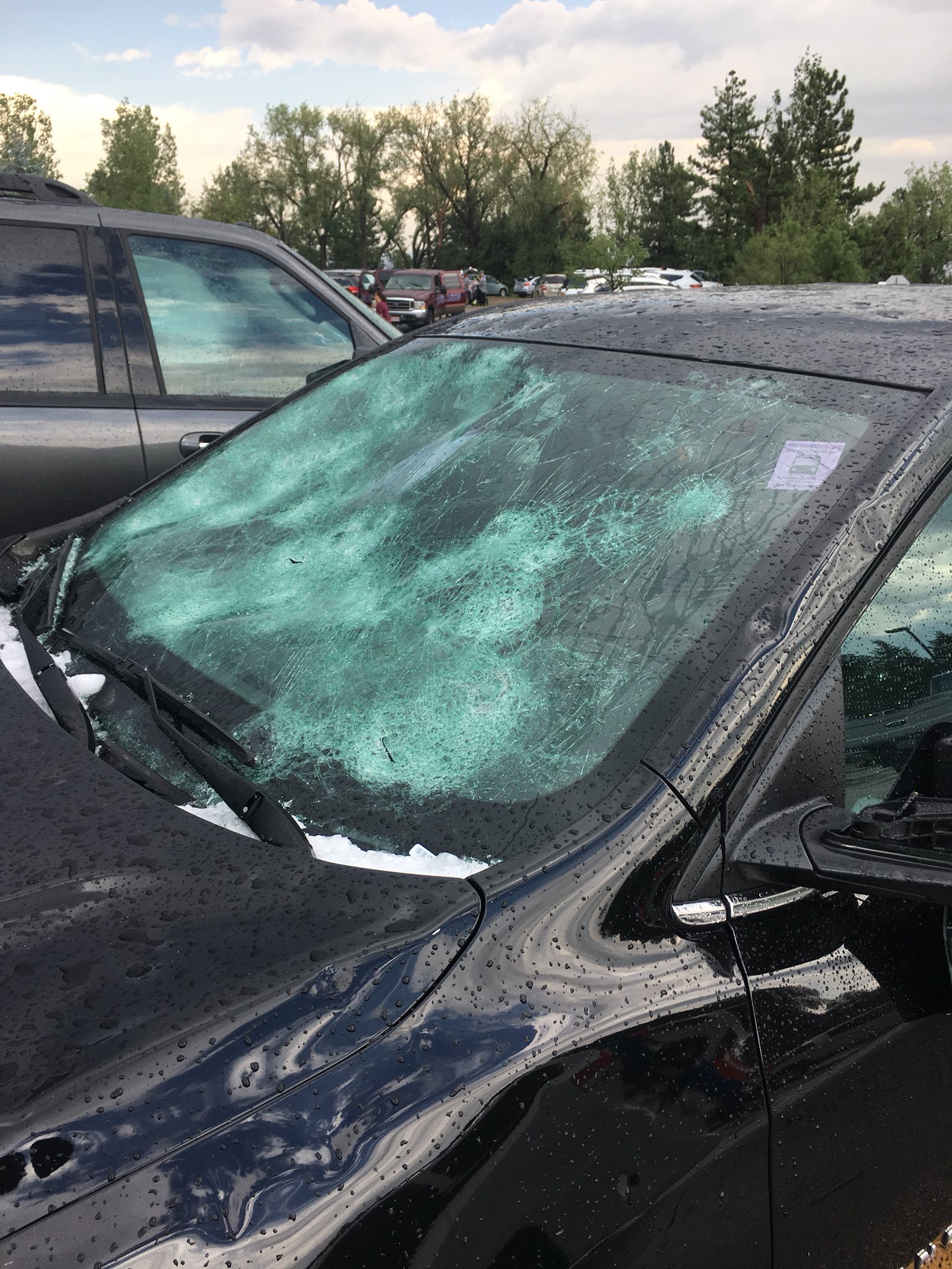
Various photos of hail and hail damage in El Paso County on August 6th, 2018.
 |
 |
 |
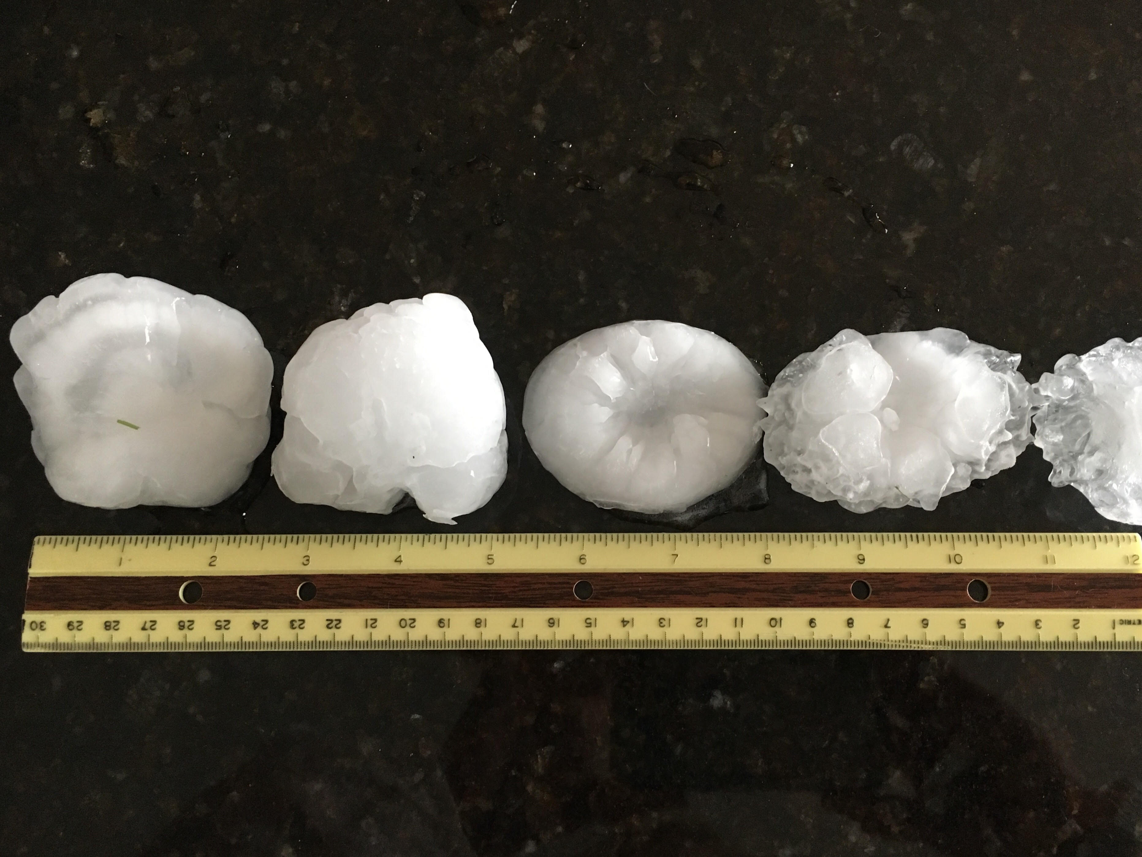 |
| Broadmoor Bluffs Hail Stone | Hail next to a Hail Card | Large Hail | Hail Stones in Fountain, CO Courtesy of Jennifer Stark |
 |
 |
 |
 |
| Cheyenne Mountain Zoo Vehicle Damage | Cheyenne Mountain Zoo Vehicle Damage | Cheyenne Mountain Zoo Damage | Broken Windows at Cheyenne Mountain Zoo |
 |
 |
 |
 |
| Hail Stones that Fell at Fort Carson, Colorado | Hail Stones that Fell in SW Colorado Springs, Colorado (photo courtesy of Tom Magnuson) | Hail in Widefield (photo courtesy of Leslie Trujillo) | Handful of Hail |
Hail and Weather Messaging Timeline
 |
 |
| Hail Timeline Via Radar Imager (Click to Zoom) | NWS Warning and Message Timeline (Click to Zoom) |
Storm Reports
| Mon Aug 06 2018 19:30:00 GMT-0600 (Mountain Daylight Time) | Teller | 3 WNW Divide | CO | HAIL | 1 |
| Mon Aug 06 2018 20:14:00 GMT-0600 (Mountain Daylight Time) | El Paso | 3 ENE Manitou Springs | CO | HAIL | 1 |
| Mon Aug 06 2018 20:19:00 GMT-0600 (Mountain Daylight Time) | El Paso | 2 SSW Colorado Springs | CO | HAIL | 1.5 |
| Mon Aug 06 2018 20:15:00 GMT-0600 (Mountain Daylight Time) | El Paso | 2 WSW Colorado Springs | CO | HAIL | 2 |
| Mon Aug 06 2018 20:20:00 GMT-0600 (Mountain Daylight Time) | El Paso | 3 S Colorado Springs | CO | HAIL | 2.75 |
| Mon Aug 06 2018 20:15:00 GMT-0600 (Mountain Daylight Time) | El Paso | 2 NW Colorado Springs | CO | HAIL | 1 |
| Mon Aug 06 2018 20:31:00 GMT-0600 (Mountain Daylight Time) | El Paso | 1 NE Security | CO | HAIL | 1.5 |
| Mon Aug 06 2018 20:30:00 GMT-0600 (Mountain Daylight Time) | El Paso | 2 N Security | CO | HAIL | 1.5 |
| Mon Aug 06 2018 20:16:00 GMT-0600 (Mountain Daylight Time) | El Paso | 2 WSW Colorado Springs | CO | HAIL | 2.5 |
| Mon Aug 06 2018 20:30:00 GMT-0600 (Mountain Daylight Time) | El Paso | 3 SE Manitou Springs | CO | HAIL | 1.25 |
| Mon Aug 06 2018 20:40:00 GMT-0600 (Mountain Daylight Time) | El Paso | 2 E Falcon | CO | HAIL | 1.5 |
| Mon Aug 06 2018 20:40:00 GMT-0600 (Mountain Daylight Time) | El Paso | 1 ENE Falcon | CO | HAIL | 1.25 |
| Mon Aug 06 2018 20:46:00 GMT-0600 (Mountain Daylight Time) | El Paso | 3 NNE Fountain | CO | HAIL | 1.75 |
| Mon Aug 06 2018 20:10:00 GMT-0600 (Mountain Daylight Time) | El Paso | 4 SSW Black Forest | CO | HAIL | 1 |
| Mon Aug 06 2018 20:10:00 GMT-0600 (Mountain Daylight Time) | El Paso | 1 ESE Manitou Springs | CO | HAIL | 0.75 |
| Mon Aug 06 2018 20:16:00 GMT-0600 (Mountain Daylight Time) | El Paso | 1 ESE Colorado Springs | CO | HAIL | 1 |
| Mon Aug 06 2018 20:19:00 GMT-0600 (Mountain Daylight Time) | El Paso | 3 SE Manitou Springs | CO | HAIL | 1 |
| Mon Aug 06 2018 20:14:00 GMT-0600 (Mountain Daylight Time) | El Paso | 2 NW Colorado Springs | CO | HAIL | 1 |
| Mon Aug 06 2018 20:20:00 GMT-0600 (Mountain Daylight Time) | El Paso | 3 ENE Manitou Springs | CO | HAIL | 1 |
| Mon Aug 06 2018 20:19:00 GMT-0600 (Mountain Daylight Time) | El Paso | 3 WSW Colorado Springs | CO | HAIL | 2 |
| Mon Aug 06 2018 20:32:00 GMT-0600 (Mountain Daylight Time) | El Paso | 1 NE Security | CO | HAIL | 1 |
| Mon Aug 06 2018 20:34:00 GMT-0600 (Mountain Daylight Time) | El Paso | 1 NE Security | CO | HAIL | 2 |
| Mon Aug 06 2018 20:38:00 GMT-0600 (Mountain Daylight Time) | El Paso | 4 NNE Falcon | CO | HAIL | 0.75 |
| Mon Aug 06 2018 20:44:00 GMT-0600 (Mountain Daylight Time) | El Paso | 1 WNW Colorado Springs | CO | HAIL | 1 |
| Mon Aug 06 2018 20:41:00 GMT-0600 (Mountain Daylight Time) | El Paso | 9 SSW Peyton | CO | HAIL | 1 |
| Mon Aug 06 2018 20:37:00 GMT-0600 (Mountain Daylight Time) | El Paso | 3 N Fountain | CO | HAIL | 2.5 |
| Mon Aug 06 2018 20:57:00 GMT-0600 (Mountain Daylight Time) | El Paso | 2 ESE Security | CO | HAIL | 4 |
| Mon Aug 06 2018 22:08:00 GMT-0600 (Mountain Daylight Time) | Pueblo | 10 ENE Pueblo Depot | CO | HAIL | 2.5 |
| Mon Aug 06 2018 20:16:00 GMT-0600 (Mountain Daylight Time) | El Paso | 1 ESE Colorado Springs | CO | HAIL | 1 |
| Mon Aug 06 2018 21:50:00 GMT-0600 (Mountain Daylight Time) | El Paso | 4 SSW Colorado Springs | CO | HAIL | 2.75 |
| Mon Aug 06 2018 21:19:00 GMT-0600 (Mountain Daylight Time) | El Paso | 2 N Colorado Springs | CO | HAIL | 1 |
| Mon Aug 06 2018 20:46:00 GMT-0600 (Mountain Daylight Time) | El Paso | 3 NNE Fountain | CO | HAIL | 1.75 |
| Mon Aug 06 2018 22:55:00 GMT-0600 (Mountain Daylight Time) | El Paso | 13 NE Pinon | CO | HAIL | 1.75 |
| Mon Aug 06 2018 21:24:00 GMT-0600 (Mountain Daylight Time) | El Paso | 10 NE Pinon | CO | HAIL | 3 |
| Tue Aug 07 2018 00:00:00 GMT-0600 (Mountain Daylight Time) | El Paso | 6 NNW Peterson Afb | CO | HEAVY RAIN | 0.58 |
| Tue Aug 07 2018 00:15:00 GMT-0600 (Mountain Daylight Time) | El Paso | 3 SSW Colorado Springs | CO | HEAVY RAIN | 1.94 |
| Mon Aug 06 2018 23:59:00 GMT-0600 (Mountain Daylight Time) | Pueblo | 12 SSW Avondale | CO | HAIL | 1.75 |
| Tue Aug 07 2018 00:33:00 GMT-0600 (Mountain Daylight Time) | El Paso | Green Mountain Falls | CO | HEAVY RAIN | 0.7 |
| Tue Aug 07 2018 01:30:00 GMT-0600 (Mountain Daylight Time) | Las Animas | 6 E Model | CO | HAIL | 1 |
| Tue Aug 07 2018 00:45:00 GMT-0600 (Mountain Daylight Time) | El Paso | 8 S Fountain | CO | HAIL | 1 |
| Mon Aug 06 2018 20:00:00 GMT-0600 (Mountain Daylight Time) | El Paso | 4 S Colorado Springs | CO | HAIL | 2.75 |
| Mon Aug 06 2018 20:00:00 GMT-0600 (Mountain Daylight Time) | El Paso | 3 S Colorado Springs | CO | HAIL | 2.75 |
| Tue Aug 07 2018 05:59:00 GMT-0600 (Mountain Daylight Time) | El Paso | 2 NW Colorado Springs | CO | HEAVY RAIN | 0.98 |
Environment
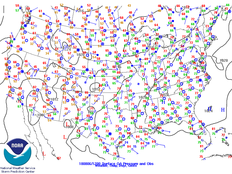
SPC Upper-Air Maps at 6AM MDT
 |
 |
| National Surface Observations | 700 hPa |
 |
 |
| 500 hPa | 300 hPa |
SPC Mesoanalysis Maps at Noon (Before Convective Initiation)
 |
 |
| Fig 1. 500 hPa | Fig 2. 700 hPa |
 |
 |
| Fig 3. 700 hPa Frontogenesis | Fig 4. 300 hPa Jet Circulation and Divergence |
 |
 |
| Fig 5. Effective Bulk Shear Vectors | Fig 6. Mid-Level Lapse Rates |
 |
 |
| Fig 7. Low-Level Lapse Rates | Fig 8. LCL Height |
 |
 |
| Fig 9. Mixed Layer CAPE | Fig 10. Theta-E and Theta-E Advection |
 |
Media use of NWS Web News Stories is encouraged! Please acknowledge the NWS as the source of any news information accessed from this site. |
|

