May 28, 2021 Upper Cumberland Tornadoes
|
A short line of thunderstorms moved across the Upper Cumberland during the early afternoon hours on Friday, May 28. This line of storms spawned two weak QLCS tornadoes that damaged several homes and businesses in Putnam and Overton Counties. Two minor injuries occurred south of Livingston in Overton County, but no injuries were reported in Putnam County. |
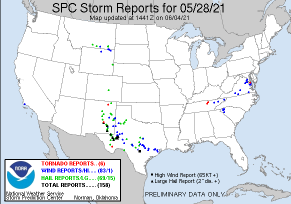
 May 28, 2021 SPC Storm Reports |
Tornadoes:
|
Tornado #1 - Cookeville, TN
Track Map  
|
||||||||||||||||
|
Tornado #2 - Livingston, TN
Track Map  
|
||||||||||||||||
The Enhanced Fujita (EF) Scale classifies tornadoes into the following categories:
| EF0 Weak 65-85 mph |
EF1 Moderate 86-110 mph |
EF2 Significant 111-135 mph |
EF3 Severe 136-165 mph |
EF4 Extreme 166-200 mph |
EF5 Catastrophic 200+ mph |
 |
|||||
Photos:
Putnam County
 |
 |
 |
|
|
Willow Avenue Church of Christ in Cookeville (Putnam County EMA) |
Hampton Creek Apartments in Cookeville (Putnam County EMA) |
Falling Water Road east of Cookeville (Putnam County EMA) |
|
Overton County
 |
 |
|
Clydesdale Farms south of Livingston (Overton County EMA) |
Clydesdale Farms south of Livingston (Overton County EMA) |
Radar:
| Radar loop from May 28, 2021. In the left pane, base reflectivity. In the right pane, storm-relative velocity. |
Storm Reports
PRELIMINARY LOCAL STORM REPORT...SUMMARY
NATIONAL WEATHER SERVICE NASHVILLE TN
959 AM CDT SUN MAY 30 2021

..TIME...   ...EVENT...      ...CITY LOCATION...     ...LAT.LON...
..DATE...   ....MAG....      ..COUNTY LOCATION..ST.. ...SOURCE....
            ..REMARKS..

1257 PM     TORNADO          2 SW COOKEVILLE         36.13N  85.53W
05/28/2021                   PUTNAM             TN   NWS STORM SURVEY

            AN EF-0 TORNADO TOUCHED DOWN NEAR SOUTH WILLOW AVENUE
            AND WINSTON DRIVE IN COOKEVILLE CAUSING MINOR DAMAGE TO
            A CHURCH...MODERATE DAMAGE TO AN OUTBUILDING AND SNAPPED
            LARGE BRANCHES FROM NEARBY TREES. IT CONTINUED TO THE
            EAST CAUSING MINOR DAMAGE TO BUILDINGS ON HWY 111 AND
            DOWNING MULTIPLE TREES IN EAST COOKEVILLE WITH WATAUGA
            DRIVE BEING THE HARDEST HIT. MORE TREES WERE BLOWN DOWN
            TO THE NORTHEAST ON FALLING WATER ROAD AND BUCK MOUNTAIN
            ROAD.

0103 PM     TSTM WND DMG     1 E COOKEVILLE          36.16N  85.49W
05/28/2021                   PUTNAM             TN   EMERGENCY MNGR

            TREES DOWN ON WATAUGA DRIVE IN EAST COOKEVILLE.

0113 PM     TORNADO          4 S LIVINGSTON          36.33N  85.33W
05/28/2021                   OVERTON            TN   EMERGENCY MNGR

            *** 2 INJ *** A BRIEF EF-0 TORNADO TOUCHED DOWN SOUTH
            OF LIVINGSTON TO THE WEST OF BILBREY ROAD. SECURITY
            CAMERA VIDEO FROM CLYDESDALE FARMS ON DALE GUNNELS LANE
            SHOWED THE TORNADO HEAVILY DAMAGING A BARN AND BLOWING
            DOWN NUMEROUS TREES. 2 PEOPLE IN THE BARN SUFFERED MINOR
            INJURIES. FURTHER TO THE EAST, MORE TREES WERE BLOWN
            DOWN ON DIFFICULT LANE BEFORE THE TORNADO LIFTED NEAR
            MONTEREY HIGHWAY.


&&

EVENT NUMBER OHX2100526 OHX2100525 OHX2100527


$$

Shamburger
Damage Surveys
Public Information Statement
National Weather Service Nashville TN
902 AM CDT Sun May 30 2021

...NWS Damage Survey for May 28, 2021 Tornado Event - Update #1...

.Update...

Two EF-0 tornadoes are now confirmed to have touched down in
Middle Tennessee on Friday, May 28, 2021 in Putnam and Overton
Counties.

.Overton County EF-0 Tornado...

Rating:                 EF0
Estimated Peak Wind:    80 mph
Path Length /statute/:  1.0008 miles
Path Width /maximum/:   50.0 yards
Fatalities:             0
Injuries:               2

Start Date:             05/28/2021
Start Time:             01:13 PM CDT
Start Location:         4 S Livingston / Overton County / TN
Start Lat/Lon:          36.3346 / -85.3294

End Date:               05/28/2021
End Time:               01:14 PM CDT
End Location:           3 SSE Livingston / Overton County / TN
End Lat/Lon:            36.3378 / -85.3118

Survey Summary:
A brief EF-0 tornado touched down south of Livingston to the west
of Bilbrey Road. Security camera video from Clydesdale Farms on
Dale Gunnels Lane showed the tornado heavily damaging a barn and
blowing down numerous trees. 2 people in the barn suffered minor
injuries. Further to the east, more trees were blown down on
Difficult Lane before the tornado lifted near Monterey Highway.

&&

EF Scale: The Enhanced Fujita Scale classifies tornadoes into the
following categories:

EF0...Weak......65 to 85 mph
EF1...Weak......86 to 110 mph
EF2...Strong....111 to 135 mph
EF3...Strong....136 to 165 mph
EF4...Violent...166 to 200 mph
EF5...Violent...>200 mph

NOTE:
The information in this statement is preliminary and subject to
change pending final review of the event and publication in NWS
Storm Data.

$$

Shamburger
 |
Media use of NWS Web News Stories is encouraged! Please acknowledge the NWS as the source of any news information accessed from this site. |
 |