|
Local WWA Map
|
Local Radar
|
Omaha Weather Story
|
|
National WWA Map
|
QPF Day 1
|
Local QPF Day 1
|
|
SPC Day 1
|
Local Severe Day 1
|
Storm Total Snow Forecast
|
NPW | WSW | WCN | SVR | TOR | SVS | LSR | FFW | FFS | FLW | FLS
CLIOMA | CLILNK | CLIOFK | CLIOAX | RTPOAX | RWRNE | RWRIA
Area Forecast Discussion
803
FXUS63 KOAX 161118
AFDOAX

Area Forecast Discussion
National Weather Service Omaha/Valley NE
618 AM CDT Wed Apr 16 2025

.KEY MESSAGES...

- Very high fire danger expected today with south winds gusting
  25 to 30 mph.

- Increasing amounts of near surface smoke through mid-morning
  today due to seasonal burning across the Kansas Flint Hills.
  Additional smoke may move in by late afternoon depending how
  many fires are going in the area.

- There is a 30-50% chance of storms late tonight into early
  Thursday. A few storms could be severe in southeast
  NE/southwest IA (5-15% chance) with hail and gusty winds the
  primary threats.

- There is an additional severe weather threat late Thursday
  afternoon into the evening (15-30% chance, mainly 5-10 PM).
  The primary threat will be large hail, but a few damaging wind
  gusts are also possible and a tornado cannot be ruled out.

- Shower and storm chances return to the region Sunday into
  Monday, though confidence is low in exact timing/placement of
  the heaviest rain.

&&

.DISCUSSION...
Issued at 341 AM CDT Wed Apr 16 2025

Pretty quiet across the region early this morning as an upper level
ridge axis was approaching and we remained on the western periphery
of a surface ridge. To our west, surface low pressure was starting
to organize east of the Rockies leading to a tightening pressure
gradient and strengthening southerly flow. As a result, we had a
fairly large temperature difference from west to east across the
area as of 3 AM, with breezier western areas still in the mid
40s to lower 50s and calmer portions of southwest IA in the mid
30s. Otherwise, as those southerly winds continue to pick up
near-surface smoke from fires to our south is progged to move
into the area and lead to decreasing air quality through mid-
morning. An air quality alert remains in effect for eastern NE.

The main story for today will be very high fire danger as the
aforementioned southerly winds pick up further, with gusts of 25
to 30 mph, temperatures back in the mid 70s to lower 80s, and
RH falling into the lower to mid 20s. Model soundings do show
some potential for occasional higher gusts with 30 kts at the
top of the mixed layer, but those stronger winds aloft are
progged to exit the area by late morning/early afternoon, so any
resulting stronger gusts are not currently expected to coincide
with the lowest RH values. Should also note that the latest
HRRR guidance suggests near surface smoke could return to
portions of southeast NE into southwest IA by late this
afternoon/early evening, but it will depend on how many fires
are going to our south.

Attention then turns to shower and storm chances by midnight or
shortly after as some weak shortwave energy starts to push in and
low level moisture transport strengthens and points into the area.
Latest guidance suggests a decent environment for severe hail with
MUCAPE in the 1000-2000 J/kg range and 45-55 kts of deep layer shear
across southeast NE into southwest IA. While many CAMs keep much of
the storm development confined to KS, given the moisture transport
pointing into the area and the shortwave energy moving directly
through the area, find it hard to believe we won`t get at least some
thunderstorm development in the early morning hours Thursday.

Most guidance suggests any storms that do develop push east of the
area by 7-8 AM. However, we`ll see another chance of strong to
severe storms by late Thursday afternoon into the evening, though
unfortunately there remains a decent amount of model spread
regarding some of the key features. The general setup is that a
surface low will push eastward along or just south of the NE/KS
border as some additional shortwave energy pushes through.
Meanwhile, a surface cold front will be pushing in from the
northwest while a dryline bulges into southeast NE. Ahead of these
features, strong southerly flow will continue to usher in warmer air
and more moisture, with temperatures topping out in the in the 80s
and dewpoints getting into the mid 50s to lower 60s. This should
once again lead to at least 1000-2000 J/kg of MUCAPE in the area.
Vertical shear profiles are fairly impressive, with good low-level
hodograph curvature and 50-60 kts of deep layer shear, certainly
good enough for supercells to develop as the cold front moves in.
Now for the uncertainty. The biggest questions are:

1) How quickly will the cold front push in?

Faster solutions will lead to less time for moisture/instability to
build prior to storm initiation. The HRRR had been trending
toward a faster frontal passage, but now the 16.06Z run has
slowed it back down. Overall, guidance continues to have quite a
bit of spread here.

2) How much will we mix out during the day?

Part of this will have to do with how quickly morning
convection/clouds exit the area. There will be a pretty stout EML in
place which will keep things capped through much of the afternoon
(possibly into the evening). However, some guidance suggests we mix
enough to erode most of that cap and get some surface based storms.
If this happens, damaging winds will be possible along with an
outside shot at tornado given the low level hodograph curvature, but
this scenario would also likely feature fairly high LCLs/cloud
bases which would limit that tornado threat.

In addition, there are questions about the timing/track of the
surface low which will have an impact on low level wind fields/shear
and convergence that will allow storms to develop (especially if we
erode the cap).

So with all that said, the most likely scenario seems to be we get a
few supercells by 4-5 PM as the cold front pushes into southeast NE
and southwest IA, with the main threat being large hail (possibly
larger than 2" in diameter) and perhaps a few pockets of damaging
winds. Given the strong deep layer shear, storms should be fairly
organized and long-lived and could produce some fairly long swaths
of hail. At this time, the tornado threat looks pretty conditional
and on the lower side (SPC outlook has a 2% contour), but it`s still
something worth keeping an eye on. Should also mention that this
does not look like a widespread rain. There could be a few stripes
of 0.25-0.50"+ with any supercells, but they could also be
accompanied by large hail. Areas outside of these stripes would
likely only get a few hundredths, if anything.

The severe weather threat should exit by 10 PM with perhaps a few
lingering light showers in northeast NE into Friday morning as
additional weak shortwave energy slides through. Behind the front
we`ll be much cooler on Friday, with highs in the 50s to lower 60s.

Heading into the weekend, the big question will be the timing and
track of an ejecting trough and associated surface low that`s
progged to develop over TX and push northeast through the Plains.
There is still A LOT of spread in the track of this low and
associated precipitation. EPS guidance consensus favors a track over
the NE/KS/IA/MO border area which would give us a fairly widespread
swath of 0.25-0.75", but individual members range from eastern NE to
the IL/IN border. On the other hand, GEFS is generally much farther
east, with many members completely shutting us out on precip (though
there are a few members that are more in line with what EPS shows).
So bottom line, our best chances for widespread rain will be
sometime Saturday night through early Monday (currently a 30-60%
chance), but overall forecast confidence in this period remains
quite low.

Behind that system, we`ll see some mid-level height rises and a
return of southerly flow which should allow us to warm back up into
the mid 60s to mid 70s following the upper 50s to lower 60s over the
weekend. We`ll also see a continued train of weak bits of shortwave
energy bringing occasional shower and storm chances, though
confidence in timing and track of any one of these is rather low,
with model consensus giving a persistent 20-30% chance from Tuesday
morning onward.

&&

.AVIATION /12Z TAFS THROUGH 12Z THURSDAY/...
Issued at 604 AM CDT Wed Apr 16 2025

VFR conditions will prevail through the majority of the period.
LLWS will continue at all three TAF sites until 14Z. Winds will
remain out of the SSE at 12-15 kts, with occasional gusts up to
20-25 kts. Winds decrease slightly after 00Z and back to the
southeast. Shower and thunderstorm chances increase at the tail
end of this TAF period. While the best chance for precipitation
will remain south of KLNK, a few showers and storms could reach
farther north. Although chances remain too low to include a
mention in TAFs at this time, the greatest chance(20-30%) would
be from 06-12Z. Reduced ceilings (MVFR & IFR) would be possible
with any storms that do develop.

&&

.OAX WATCHES/WARNINGS/ADVISORIES...
NE...None.
IA...None.

&&

$$

DISCUSSION...CA
AVIATION...KG
Hazardous Weather Outlook
172
FLUS43 KOAX 160923
HWOOAX

Hazardous Weather Outlook
National Weather Service Omaha/Valley NE
423 AM CDT Wed Apr 16 2025

IAZ043-055-056-069-079-080-090-091-NEZ011-012-015>018-030>034-
042>045-050>053-065>068-078-088>093-171200-
Monona-Harrison-Shelby-Pottawattamie-Mills-Montgomery-Fremont-
Page-Knox-Cedar-Thurston-Antelope-Pierce-Wayne-Boone-Madison-
Stanton-Cuming-Burt-Platte-Colfax-Dodge-Washington-Butler-
Saunders-Douglas-Sarpy-Seward-Lancaster-Cass-Otoe-Saline-
Jefferson-Gage-Johnson-Nemaha-Pawnee-Richardson-
423 AM CDT Wed Apr 16 2025

This Hazardous Weather Outlook is for portions of southwest
Iowa...west central Iowa...east central Nebraska...northeast
Nebraska and southeast Nebraska.

.DAY ONE...Today and Tonight

Very high fire danger is expected today with south to southeast
winds gusting 25 to 30 mph across much of the area.

Thunderstorm chances return late tonight into early Thursday, with
a 5 to 15% chance of severe storms, mainly in southeast Nebraska
and southwest Iowa. The primary threats will be hail and gusty
winds.

.DAYS TWO THROUGH SEVEN...Thursday through Tuesday

There are additional thunderstorm chances late Thursday afternoon
into the evening, with a 15-30% chance of severe storms, mainly
from 5 PM to 10 PM. The primary threat will be large hail, but a
few damaging wind gusts are also possible and a tornado cannot be
ruled out.

.SPOTTER INFORMATION STATEMENT...

Spotter activation is not expected through Thursday morning, but
reports of severe weather are appreciated.

$$
Zone Forecast
142
FPUS53 KOAX 161131
ZFPOAX

Zone Forecasts for Eastern Nebraska and Southwest Iowa
National Weather Service Omaha/Valley NE
629 AM CDT Wed Apr 16 2025

NEZ052-161900-
Douglas-
Including the city of Omaha
629 AM CDT Wed Apr 16 2025

.TODAY...Sunny, warmer with highs in the upper 70s. South winds
10 to 15 mph with gusts up to 25 mph.
.TONIGHT...Partly cloudy in the evening, then mostly cloudy with
a slight chance of showers and thunderstorms after midnight. Not
as cool with lows in the upper 50s. Southeast winds 10 to 15 mph
with gusts up to 25 mph. Chance of rain 20 percent.
.THURSDAY...Mostly sunny. A slight chance of showers and
thunderstorms in the morning, then a chance of showers and
thunderstorms in the afternoon. Highs in the lower 80s. South
winds 10 to 15 mph with gusts up to 25 mph. Chance of rain
30 percent.
.THURSDAY NIGHT...Partly cloudy in the evening, then becoming
mostly cloudy. A chance of thunderstorms in the evening. A chance
of showers. Cooler with lows in the mid 40s. North winds 15 to
20 mph. Chance of rain 40 percent.
.FRIDAY...Partly sunny. Much cooler with highs in the upper 50s.
North winds 15 to 20 mph with gusts up to 30 mph.
.FRIDAY NIGHT...Mostly cloudy in the evening, then becoming
partly cloudy. Lows in the upper 30s.
.SATURDAY...Mostly sunny. Highs around 60.
.SATURDAY NIGHT...Partly cloudy. A chance of showers after
midnight. Lows around 40. Chance of rain 30 percent.
.SUNDAY...Partly sunny with a 50 percent chance of showers. Highs
in the upper 50s.
.SUNDAY NIGHT...Mostly cloudy in the evening, then becoming
partly cloudy. A slight chance of thunderstorms in the evening. A
chance of showers. Lows in the upper 30s. Chance of rain
50 percent.
.MONDAY...Mostly sunny. A slight chance of showers in the
morning. Highs in the upper 60s. Chance of rain 20 percent.
.MONDAY NIGHT...Partly cloudy. A chance of showers after
midnight. Lows in the mid 40s. Chance of rain 30 percent.
.TUESDAY...Mostly sunny with a 40 percent chance of showers.
Highs in the lower 70s.

$$

NEZ053-161900-
Sarpy-
Including the cities of Bellevue, Papillion, and La Vista
629 AM CDT Wed Apr 16 2025

.TODAY...Sunny, warmer with highs in the upper 70s. South winds
10 to 15 mph with gusts up to 25 mph.
.TONIGHT...Partly cloudy in the evening, then mostly cloudy with
a chance of showers and thunderstorms after midnight. Not as cool
with lows in the upper 50s. Southeast winds 10 to 15 mph with
gusts up to 25 mph. Chance of rain 30 percent.
.THURSDAY...Mostly sunny. A slight chance of showers and
thunderstorms in the morning, then a chance of showers and
thunderstorms in the afternoon. Highs in the lower 80s. South
winds 10 to 15 mph with gusts up to 25 mph. Chance of rain
30 percent.
.THURSDAY NIGHT...A slight chance of thunderstorms in the
evening. Partly cloudy with a chance of showers. Cooler with lows
in the upper 40s. Northeast winds 10 to 15 mph, becoming north
after midnight. Chance of rain 40 percent.
.FRIDAY...Partly sunny. Much cooler with highs in the upper 50s.
North winds around 15 mph with gusts up to 25 mph.
.FRIDAY NIGHT...Mostly cloudy in the evening, then becoming
partly cloudy. Lows in the upper 30s.
.SATURDAY...Mostly sunny. Highs around 60.
.SATURDAY NIGHT...Partly cloudy in the evening, then mostly
cloudy with a chance of showers after midnight. Lows around 40.
Chance of rain 30 percent.
.SUNDAY...Partly sunny with a 50 percent chance of showers. Highs
in the upper 50s.
.SUNDAY NIGHT...Mostly cloudy in the evening, then becoming
partly cloudy. A slight chance of thunderstorms in the evening. A
chance of showers. Lows in the upper 30s. Chance of rain
50 percent.
.MONDAY...Mostly sunny. Highs in the upper 60s.
.MONDAY NIGHT...Partly cloudy. A chance of showers after
midnight. Lows in the mid 40s. Chance of rain 30 percent.
.TUESDAY...Mostly sunny with a 40 percent chance of showers.
Highs in the lower 70s.

$$

IAZ069-161900-
Pottawattamie-
Including the city of Council Bluffs
629 AM CDT Wed Apr 16 2025

.TODAY...Sunny, warmer with highs in the mid 70s. South winds
15 to 20 mph with gusts up to 30 mph.
.TONIGHT...Partly cloudy in the evening, then mostly cloudy with
a slight chance of showers and thunderstorms after midnight. Not
as cool with lows in the mid 50s. Southeast winds 15 to 20 mph.
Chance of rain 20 percent.
.THURSDAY...Partly sunny with a slight chance of thunderstorms. A
chance of showers, mainly in the morning. Highs around 80. South
winds 15 to 20 mph with gusts up to 30 mph. Chance of rain
30 percent.
.THURSDAY NIGHT...A chance of thunderstorms in the evening.
Partly cloudy with a chance of showers. Lows in the upper 40s.
West winds around 15 mph, becoming north after midnight. Chance
of rain 50 percent.
.FRIDAY...Partly sunny. A slight chance of showers in the
morning. Much cooler with highs in the upper 50s. North winds
15 to 20 mph. Chance of rain 20 percent.
.FRIDAY NIGHT...Mostly cloudy in the evening, then becoming
partly cloudy. Lows in the upper 30s.
.SATURDAY...Mostly sunny. Highs around 60.
.SATURDAY NIGHT...Partly cloudy. A slight chance of showers after
midnight. Lows in the upper 30s. Chance of rain 20 percent.
.SUNDAY...Partly sunny with a 50 percent chance of showers. Highs
in the upper 50s.
.SUNDAY NIGHT...A slight chance of thunderstorms in the evening.
Mostly cloudy with a chance of showers. Lows in the upper 30s.
Chance of rain 50 percent.
.MONDAY...Mostly sunny. A slight chance of showers in the
morning. Highs in the mid 60s. Chance of rain 20 percent.
.MONDAY NIGHT...Partly cloudy. A chance of showers after
midnight. Lows in the mid 40s. Chance of rain 30 percent.
.TUESDAY...Mostly sunny with a 40 percent chance of showers.
Highs around 70.

$$

NEZ066-161900-
Lancaster-
Including the city of Lincoln
629 AM CDT Wed Apr 16 2025

.TODAY...Sunny, warmer with highs in the upper 70s. South winds
15 to 20 mph with gusts up to 30 mph.
.TONIGHT...Partly cloudy in the evening, then mostly cloudy with
a chance of showers and thunderstorms after midnight. Not as cool
with lows in the upper 50s. South winds 10 to 15 mph with gusts
up to 25 mph. Chance of rain 30 percent.
.THURSDAY...Mostly sunny with a slight chance of thunderstorms. A
slight chance of showers in the morning, then a chance of showers
in the afternoon. Highs in the mid 80s. South winds 10 to 15 mph
with gusts up to 25 mph. Chance of rain 30 percent.
.THURSDAY NIGHT...A slight chance of thunderstorms in the
evening. Partly cloudy with a slight chance of showers. Cooler
with lows in the mid 40s. North winds 15 to 20 mph with gusts up
to 30 mph. Chance of rain 20 percent.
.FRIDAY...Partly sunny. Much cooler with highs in the upper 50s.
North winds 15 to 20 mph with gusts up to 30 mph.
.FRIDAY NIGHT...Partly cloudy. Lows in the upper 30s.
.SATURDAY...Mostly sunny. Highs around 60.
.SATURDAY NIGHT...Partly cloudy with a slight chance of showers
in the evening, then mostly cloudy with a chance of showers after
midnight. Lows in the upper 30s. Chance of rain 30 percent.
.SUNDAY...Partly sunny with a 50 percent chance of showers. Highs
around 60.
.SUNDAY NIGHT...Mostly cloudy with a chance of showers in the
evening, then partly cloudy with a slight chance of showers after
midnight. Lows in the upper 30s. Chance of rain 50 percent.
.MONDAY...Sunny, warmer with highs in the lower 70s.
.MONDAY NIGHT...Mostly clear in the evening, then partly cloudy
with a chance of showers with a slight chance of thunderstorms
after midnight. Lows in the upper 40s. Chance of rain 30 percent.
.TUESDAY...Mostly sunny with a 40 percent chance of showers.
Highs in the lower 70s.

$$

NEZ031-161900-
Madison-
Including the city of Norfolk
629 AM CDT Wed Apr 16 2025

.TODAY...Sunny, warmer with highs in the upper 70s. South winds
15 to 20 mph.
.TONIGHT...Partly cloudy in the evening, then mostly cloudy with
a slight chance of showers after midnight. Not as cool with lows
in the mid 50s. Southeast winds 10 to 15 mph. Chance of rain
20 percent.
.THURSDAY...Partly sunny. A slight chance of showers in the
morning, then a chance of showers with a slight chance of
thunderstorms in the afternoon. Highs around 80. South winds
10 to 15 mph, becoming west 15 to 20 mph in the afternoon. Chance
of rain 40 percent.
.THURSDAY NIGHT...Partly cloudy in the evening, then becoming
mostly cloudy. A slight chance of thunderstorms in the evening. A
chance of showers. Breezy and much cooler with lows in the upper
30s. North winds 20 to 25 mph with gusts up to 35 mph. Chance of
rain 50 percent.
.FRIDAY...Mostly cloudy. A slight chance of showers in the
morning. Breezy and much cooler with highs in the lower 50s.
North winds 20 to 25 mph. Chance of rain 20 percent.
.FRIDAY NIGHT...Mostly cloudy in the evening, then becoming
partly cloudy. Lows in the lower 30s.
.SATURDAY...Mostly sunny. Highs in the upper 50s.
.SATURDAY NIGHT...Partly cloudy. A slight chance of showers in
the evening, then a chance of showers after midnight. Lows in the
mid 30s. Chance of rain 30 percent.
.SUNDAY...Partly sunny with a 40 percent chance of rain showers.
Highs in the upper 50s.
.SUNDAY NIGHT...Mostly cloudy with a chance of showers in the
evening, then partly cloudy with a slight chance of showers after
midnight. Lows in the mid 30s. Chance of rain 40 percent.
.MONDAY...Sunny, warmer with highs in the upper 60s.
.MONDAY NIGHT...Partly cloudy. A chance of showers with a slight
chance of thunderstorms after midnight. Lows in the mid 40s.
Chance of rain 30 percent.
.TUESDAY...Mostly sunny with a 30 percent chance of showers.
Highs in the upper 60s.

$$

NEZ011-161900-
Knox-
Including the cities of Creighton, Bloomfield, Crofton, Wausa,
Verdigre, and Niobrara
629 AM CDT Wed Apr 16 2025

.TODAY...Sunny, warmer with highs in the upper 70s. South winds
10 to 15 mph with gusts up to 25 mph.
.TONIGHT...Partly cloudy in the evening, then becoming mostly
cloudy. Not as cool with lows in the mid 50s. Southeast winds
10 to 15 mph with gusts up to 25 mph.
.THURSDAY...Mostly sunny. A slight chance of showers in the
morning, then a chance of showers in the afternoon. Highs in the
mid 70s. South winds 10 to 15 mph, becoming northwest 15 to
20 mph with gusts up to 30 mph in the afternoon. Chance of rain
30 percent.
.THURSDAY NIGHT...Mostly cloudy with a slight chance of
thunderstorms. A chance of showers in the evening, then showers
likely after midnight. Breezy and much cooler with lows in the
upper 30s. North winds 15 to 25 mph. Chance of rain 60 percent.
.FRIDAY...Mostly cloudy. A chance of showers in the morning. Much
cooler with highs in the lower 50s. North winds 15 to 20 mph with
gusts up to 30 mph. Chance of rain 30 percent.
.FRIDAY NIGHT...Mostly cloudy in the evening, then becoming
partly cloudy. Lows in the lower 30s.
.SATURDAY...Mostly sunny. Highs in the upper 50s.
.SATURDAY NIGHT...Partly cloudy. A slight chance of rain showers
after midnight. Lows in the mid 30s. Chance of rain 20 percent.
.SUNDAY...Mostly sunny with a 40 percent chance of rain showers.
Highs in the upper 50s.
.SUNDAY NIGHT...Mostly cloudy with a chance of rain showers in
the evening, then partly cloudy with a slight chance of rain
showers after midnight. Lows in the mid 30s. Chance of rain
40 percent.
.MONDAY...Mostly sunny. Highs in the upper 60s.
.MONDAY NIGHT...Partly cloudy. A slight chance of showers in the
evening, then a chance of showers after midnight. Lows in the
lower 40s. Chance of rain 30 percent.
.TUESDAY...Mostly sunny with a 30 percent chance of showers.
Highs in the upper 60s.

$$

NEZ012-161900-
Cedar-
Including the cities of Hartington, Laurel, Randolph,
and Coleridge
629 AM CDT Wed Apr 16 2025

.TODAY...Sunny, warmer with highs in the mid 70s. Southeast winds
15 to 20 mph.
.TONIGHT...Partly cloudy. Not as cool with lows in the mid 50s.
Southeast winds around 15 mph with gusts up to 25 mph.
.THURSDAY...Partly sunny with a chance of showers. A slight
chance of thunderstorms in the afternoon. Highs in the upper 70s.
South winds 10 to 15 mph, becoming west 15 to 20 mph in the
afternoon. Chance of rain 30 percent.
.THURSDAY NIGHT...Partly cloudy with a chance of showers and
thunderstorms in the evening, then mostly cloudy with showers
likely with a slight chance of thunderstorms after midnight.
Breezy and much cooler with lows in the upper 30s. North winds
20 to 25 mph with gusts up to 35 mph. Chance of rain 60 percent.
.FRIDAY...Mostly cloudy. A chance of showers in the morning.
Breezy and much cooler with highs in the lower 50s. North winds
20 to 25 mph. Chance of rain 30 percent.
.FRIDAY NIGHT...Mostly cloudy in the evening, then clearing. Lows
in the lower 30s.
.SATURDAY...Mostly sunny. Highs in the upper 50s.
.SATURDAY NIGHT...Partly cloudy. A slight chance of rain showers
after midnight. Lows in the mid 30s. Chance of rain 20 percent.
.SUNDAY...Partly sunny with a 40 percent chance of rain showers.
Highs in the upper 50s.
.SUNDAY NIGHT...Mostly cloudy with a chance of showers in the
evening, then partly cloudy with a slight chance of showers after
midnight. Lows in the upper 30s. Chance of rain 40 percent.
.MONDAY...Mostly sunny. A slight chance of showers in the
morning. Highs in the upper 60s. Chance of rain 20 percent.
.MONDAY NIGHT...Partly cloudy. A slight chance of showers in the
evening, then a chance of showers after midnight. Lows in the
lower 40s. Chance of rain 30 percent.
.TUESDAY...Mostly sunny with a 40 percent chance of showers.
Highs in the upper 60s.

$$

NEZ016-161900-
Antelope-
Including the cities of Neligh and Elgin
629 AM CDT Wed Apr 16 2025

.TODAY...Sunny, warmer with highs in the upper 70s. South winds
10 to 15 mph.
.TONIGHT...Partly cloudy in the evening, then becoming mostly
cloudy. Not as cool with lows in the mid 50s. Southeast winds
10 to 15 mph.
.THURSDAY...Mostly sunny. A slight chance of showers in the
morning, then a chance of showers in the afternoon. Highs in the
mid 70s. South winds 10 to 15 mph, becoming northwest 15 to
20 mph with gusts up to 30 mph in the afternoon. Chance of rain
30 percent.
.THURSDAY NIGHT...Partly cloudy in the evening, then becoming
mostly cloudy. A chance of showers with a slight chance of
thunderstorms. Breezy and much cooler with lows in the upper 30s.
North winds 20 to 25 mph with gusts up to 35 mph. Chance of rain
50 percent.
.FRIDAY...Mostly cloudy. A slight chance of showers in the
morning. Breezy and much cooler with highs in the lower 50s.
North winds 15 to 25 mph. Chance of rain 20 percent.
.FRIDAY NIGHT...Mostly cloudy in the evening, then becoming
partly cloudy. Lows in the lower 30s.
.SATURDAY...Mostly sunny. Highs in the upper 50s.
.SATURDAY NIGHT...Partly cloudy. A slight chance of showers after
midnight. Lows in the mid 30s. Chance of rain 20 percent.
.SUNDAY...Partly sunny with a 40 percent chance of rain showers.
Highs in the upper 50s.
.SUNDAY NIGHT...Mostly cloudy with a chance of rain showers in
the evening, then partly cloudy with a slight chance of rain
showers after midnight. Lows in the mid 30s. Chance of rain
40 percent.
.MONDAY...Mostly sunny. Warmer with highs in the upper 60s.
.MONDAY NIGHT...Partly cloudy with a slight chance of
thunderstorms. A slight chance of showers in the evening, then a
chance of showers after midnight. Lows in the mid 40s. Chance of
rain 30 percent.
.TUESDAY...Mostly sunny. A chance of showers, mainly in the
morning. Highs in the upper 60s. Chance of rain 30 percent.

$$

NEZ017-161900-
Pierce-
Including the cities of Pierce, Plainview, and Osmond
629 AM CDT Wed Apr 16 2025

.TODAY...Sunny, warmer with highs in the upper 70s. South winds
10 to 15 mph with gusts up to 25 mph.
.TONIGHT...Partly cloudy in the evening, then becoming mostly
cloudy. Not as cool with lows in the mid 50s. Southeast winds
10 to 15 mph with gusts up to 25 mph.
.THURSDAY...Partly sunny. A slight chance of showers in the
morning, then a chance of showers with a slight chance of
thunderstorms in the afternoon. Highs in the upper 70s. South
winds 10 to 15 mph, becoming west 15 to 20 mph with gusts up to
30 mph in the afternoon. Chance of rain 30 percent.
.THURSDAY NIGHT...Partly cloudy in the evening, then becoming
mostly cloudy. A chance of showers with a slight chance of
thunderstorms. Breezy and much cooler with lows in the upper 30s.
North winds 20 to 25 mph with gusts up to 35 mph. Chance of rain
50 percent.
.FRIDAY...Mostly cloudy. A slight chance of showers in the
morning. Breezy and much cooler with highs in the lower 50s.
North winds 20 to 25 mph. Chance of rain 20 percent.
.FRIDAY NIGHT...Mostly cloudy in the evening, then clearing. Lows
in the lower 30s.
.SATURDAY...Mostly sunny. Highs in the upper 50s.
.SATURDAY NIGHT...Partly cloudy. A slight chance of rain showers
after midnight. Lows in the mid 30s. Chance of rain 20 percent.
.SUNDAY...Partly sunny with a 40 percent chance of rain showers.
Highs in the upper 50s.
.SUNDAY NIGHT...Mostly cloudy with a chance of rain showers in
the evening, then partly cloudy with a slight chance of rain
showers after midnight. Lows in the mid 30s. Chance of rain
40 percent.
.MONDAY...Sunny, warmer with highs in the upper 60s.
.MONDAY NIGHT...Partly cloudy. A slight chance of showers in the
evening, then a chance of showers after midnight. Lows in the mid
40s. Chance of rain 30 percent.
.TUESDAY...Mostly sunny. A chance of showers, mainly in the
morning. Highs in the upper 60s. Chance of rain 30 percent.

$$

NEZ018-161900-
Wayne-
Including the city of Wayne
629 AM CDT Wed Apr 16 2025

.TODAY...Sunny, warmer with highs in the upper 70s. South winds
15 to 20 mph.
.TONIGHT...Partly cloudy in the evening, then mostly cloudy with
a slight chance of showers after midnight. Not as cool with lows
in the mid 50s. Southeast winds 10 to 15 mph with gusts up to
25 mph. Chance of rain 20 percent.
.THURSDAY...Partly sunny with a chance of showers. A slight
chance of thunderstorms in the afternoon. Highs in the upper 70s.
South winds 10 to 15 mph, becoming southwest 15 to 20 mph in the
afternoon. Chance of rain 40 percent.
.THURSDAY NIGHT...Partly cloudy in the evening, then becoming
mostly cloudy. A slight chance of thunderstorms. A chance of
showers in the evening, then showers likely after midnight.
Breezy and much cooler with lows in the upper 30s. North winds
15 to 25 mph with gusts up to 35 mph. Chance of rain 60 percent.
.FRIDAY...Mostly cloudy. A chance of showers in the morning.
Breezy and much cooler with highs in the mid 50s. North winds
20 to 25 mph. Chance of rain 50 percent.
.FRIDAY NIGHT...Mostly cloudy in the evening, then clearing. Lows
in the lower 30s.
.SATURDAY...Mostly sunny. Highs in the upper 50s.
.SATURDAY NIGHT...Partly cloudy. A slight chance of rain showers
after midnight. Lows in the mid 30s. Chance of rain 20 percent.
.SUNDAY...Partly sunny with a 40 percent chance of rain showers.
Highs in the upper 50s.
.SUNDAY NIGHT...Mostly cloudy with a chance of showers in the
evening, then partly cloudy with a slight chance of showers after
midnight. Lows in the mid 30s. Chance of rain 40 percent.
.MONDAY...Mostly sunny. A slight chance of rain showers in the
morning. Highs in the upper 60s. Chance of rain 20 percent.
.MONDAY NIGHT...Partly cloudy. A slight chance of showers in the
evening, then a chance of showers after midnight. Lows in the
lower 40s. Chance of rain 30 percent.
.TUESDAY...Mostly sunny with a 40 percent chance of showers.
Highs in the upper 60s.

$$

NEZ015-161900-
Thurston-
Including the cities of Pender, Macy, Walthill, and Winnebago
629 AM CDT Wed Apr 16 2025

.TODAY...Sunny, warmer with highs in the mid 70s. South winds
15 to 20 mph.
.TONIGHT...Partly cloudy in the evening, then mostly cloudy with
a slight chance of showers and thunderstorms after midnight. Not
as cool with lows in the mid 50s. Southeast winds around 15 mph
with gusts up to 25 mph. Chance of rain 20 percent.
.THURSDAY...Partly sunny with a chance of showers. A slight
chance of thunderstorms in the morning, then a chance of
thunderstorms in the afternoon. Highs around 80. South winds
10 to 15 mph with gusts up to 25 mph. Chance of rain 40 percent.
.THURSDAY NIGHT...Partly cloudy in the evening, then becoming
mostly cloudy. A chance of thunderstorms in the evening. A chance
of showers. Breezy, cooler with lows in the lower 40s. North
winds 20 to 25 mph. Chance of rain 50 percent.
.FRIDAY...Mostly cloudy. A slight chance of showers in the
morning. Breezy and much cooler with highs in the mid 50s. North
winds 20 to 25 mph with gusts up to 35 mph. Chance of rain
20 percent.
.FRIDAY NIGHT...Mostly cloudy in the evening, then clearing. Lows
in the lower 30s.
.SATURDAY...Mostly sunny. Highs in the upper 50s.
.SATURDAY NIGHT...Partly cloudy. A slight chance of showers after
midnight. Lows in the mid 30s. Chance of rain 20 percent.
.SUNDAY...Partly sunny with a 40 percent chance of rain showers.
Highs in the upper 50s.
.SUNDAY NIGHT...Mostly cloudy in the evening, then becoming
partly cloudy. A 40 percent chance of showers. Lows in the mid
30s.
.MONDAY...Mostly sunny. A slight chance of rain showers in the
morning. Highs in the upper 60s. Chance of rain 20 percent.
.MONDAY NIGHT...Partly cloudy. A slight chance of showers in the
evening, then a chance of showers after midnight. Lows in the
lower 40s. Chance of rain 30 percent.
.TUESDAY...Mostly sunny with a 40 percent chance of showers.
Highs in the upper 60s.

$$

NEZ032-161900-
Stanton-
Including the city of Stanton
629 AM CDT Wed Apr 16 2025

.TODAY...Sunny, warmer with highs in the upper 70s. South winds
15 to 20 mph with gusts up to 30 mph.
.TONIGHT...Partly cloudy in the evening, then mostly cloudy with
a slight chance of showers after midnight. Not as cool with lows
in the mid 50s. Southeast winds 10 to 15 mph. Chance of rain
20 percent.
.THURSDAY...Partly sunny. A slight chance of showers in the
morning, then a chance of showers with a slight chance of
thunderstorms in the afternoon. Highs around 80. South winds
10 to 15 mph, becoming southwest in the afternoon. Chance of rain
40 percent.
.THURSDAY NIGHT...Partly cloudy in the evening, then becoming
mostly cloudy. A slight chance of thunderstorms in the evening. A
chance of showers. Breezy, cooler with lows around 40. North
winds 15 to 25 mph with gusts up to 35 mph. Chance of rain
50 percent.
.FRIDAY...Partly sunny with a slight chance of showers in the
morning, then mostly cloudy in the afternoon. Breezy and much
cooler with highs in the mid 50s. North winds 20 to 25 mph.
Chance of rain 20 percent.
.FRIDAY NIGHT...Mostly cloudy in the evening, then becoming
partly cloudy. Lows in the lower 30s.
.SATURDAY...Mostly sunny. Highs in the upper 50s.
.SATURDAY NIGHT...Partly cloudy. A slight chance of showers in
the evening, then a chance of showers after midnight. Lows in the
mid 30s. Chance of rain 30 percent.
.SUNDAY...Partly sunny with a 40 percent chance of showers. Highs
in the upper 50s.
.SUNDAY NIGHT...Mostly cloudy with a chance of showers in the
evening, then partly cloudy with a slight chance of showers after
midnight. Lows in the mid 30s. Chance of rain 40 percent.
.MONDAY...Mostly sunny. Warmer with highs in the upper 60s.
.MONDAY NIGHT...Partly cloudy. A chance of showers after
midnight. Lows in the mid 40s. Chance of rain 30 percent.
.TUESDAY...Mostly sunny with a 40 percent chance of showers.
Highs in the upper 60s.

$$

NEZ033-161900-
Cuming-
Including the cities of West Point and Wisner
629 AM CDT Wed Apr 16 2025

.TODAY...Sunny, warmer with highs in the upper 70s. South winds
15 to 20 mph.
.TONIGHT...Partly cloudy in the evening, then mostly cloudy with
a slight chance of showers and thunderstorms after midnight. Not
as cool with lows in the mid 50s. Southeast winds 15 to 20 mph.
Chance of rain 20 percent.
.THURSDAY...Partly sunny. A slight chance of showers and
thunderstorms in the morning, then a chance of showers and
thunderstorms in the afternoon. Highs around 80. South winds
10 to 15 mph with gusts up to 25 mph. Chance of rain 40 percent.
.THURSDAY NIGHT...Partly cloudy in the evening, then becoming
mostly cloudy. A slight chance of thunderstorms in the evening. A
chance of showers. Breezy, cooler with lows in the lower 40s.
North winds 20 to 25 mph. Chance of rain 50 percent.
.FRIDAY...Partly sunny with a slight chance of showers in the
morning, then mostly cloudy in the afternoon. Breezy and much
cooler with highs in the mid 50s. North winds 20 to 25 mph with
gusts up to 35 mph. Chance of rain 20 percent.
.FRIDAY NIGHT...Mostly cloudy in the evening, then clearing. Lows
in the lower 30s.
.SATURDAY...Mostly sunny. Highs in the upper 50s.
.SATURDAY NIGHT...Partly cloudy. A slight chance of showers after
midnight. Lows in the mid 30s. Chance of rain 20 percent.
.SUNDAY...Partly sunny with a 40 percent chance of showers. Highs
in the upper 50s.
.SUNDAY NIGHT...Mostly cloudy with a chance of showers in the
evening, then partly cloudy with a slight chance of showers after
midnight. Lows in the mid 30s. Chance of rain 40 percent.
.MONDAY...Mostly sunny. Warmer with highs in the upper 60s.
.MONDAY NIGHT...Partly cloudy. A chance of showers after
midnight. Lows in the mid 40s. Chance of rain 30 percent.
.TUESDAY...Mostly sunny with a 40 percent chance of showers.
Highs around 70.

$$

NEZ034-161900-
Burt-
Including the cities of Tekamah, Oakland, Lyons, and Decatur
629 AM CDT Wed Apr 16 2025

.TODAY...Sunny, warmer with highs in the mid 70s. South winds
15 to 20 mph.
.TONIGHT...Mostly clear in the evening, then mostly cloudy with a
slight chance of showers and thunderstorms after midnight. Not as
cool with lows in the mid 50s. Southeast winds around 15 mph with
gusts up to 25 mph. Chance of rain 20 percent.
.THURSDAY...Partly sunny with a chance of showers. A slight
chance of thunderstorms in the morning, then a chance of
thunderstorms in the afternoon. Highs in the lower 80s. South
winds 10 to 15 mph with gusts up to 25 mph. Chance of rain
40 percent.
.THURSDAY NIGHT...Partly cloudy with a chance of showers and
thunderstorms in the evening, then mostly cloudy with a chance of
showers after midnight. Breezy, cooler with lows in the lower
40s. North winds 20 to 25 mph. Chance of rain 50 percent.
.FRIDAY...Partly sunny with a slight chance of showers in the
morning, then mostly cloudy in the afternoon. Breezy and much
cooler with highs in the mid 50s. North winds 20 to 25 mph with
gusts up to 35 mph. Chance of rain 20 percent.
.FRIDAY NIGHT...Mostly cloudy in the evening, then becoming
partly cloudy. Lows in the mid 30s.
.SATURDAY...Mostly sunny. Highs around 60.
.SATURDAY NIGHT...Partly cloudy. A slight chance of showers after
midnight. Lows in the upper 30s. Chance of rain 20 percent.
.SUNDAY...Partly sunny with a 50 percent chance of showers. Highs
in the upper 50s.
.SUNDAY NIGHT...Mostly cloudy in the evening, then becoming
partly cloudy. A 50 percent chance of showers. Lows in the upper
30s.
.MONDAY...Mostly sunny. A slight chance of showers in the
morning. Highs in the upper 60s. Chance of rain 20 percent.
.MONDAY NIGHT...Partly cloudy. A chance of showers after
midnight. Lows in the mid 40s. Chance of rain 30 percent.
.TUESDAY...Mostly sunny with a 40 percent chance of showers.
Highs around 70.

$$

NEZ030-161900-
Boone-
Including the cities of Albion and St. Edward
629 AM CDT Wed Apr 16 2025

.TODAY...Sunny, warmer with highs around 80. South winds 10 to
15 mph.
.TONIGHT...Partly cloudy in the evening, then mostly cloudy with
a slight chance of showers after midnight. Not as cool with lows
in the mid 50s. Southeast winds 5 to 10 mph with gusts up to
20 mph. Chance of rain 20 percent.
.THURSDAY...Mostly sunny. A slight chance of showers in the
morning, then a chance of showers with a slight chance of
thunderstorms in the afternoon. Highs in the upper 70s. South
winds 5 to 10 mph, increasing to northwest 15 to 20 mph in the
afternoon. Chance of rain 30 percent.
.THURSDAY NIGHT...Partly cloudy in the evening, then becoming
mostly cloudy. A slight chance of thunderstorms in the evening. A
chance of showers. Breezy and much cooler with lows in the upper
30s. North winds 15 to 25 mph with gusts up to 35 mph. Chance of
rain 50 percent.
.FRIDAY...Partly sunny with a slight chance of showers in the
morning, then mostly cloudy in the afternoon. Much cooler with
highs in the lower 50s. North winds 15 to 20 mph with gusts up to
30 mph. Chance of rain 20 percent.
.FRIDAY NIGHT...Mostly cloudy in the evening, then becoming
partly cloudy. Lows in the lower 30s.
.SATURDAY...Mostly sunny. Highs in the upper 50s.
.SATURDAY NIGHT...Partly cloudy. A slight chance of showers in
the evening, then a chance of showers after midnight. Lows in the
mid 30s. Chance of rain 30 percent.
.SUNDAY...Partly sunny with a 40 percent chance of rain showers.
Highs in the upper 50s.
.SUNDAY NIGHT...Mostly cloudy with a chance of showers in the
evening, then partly cloudy with a slight chance of showers after
midnight. Lows in the mid 30s. Chance of rain 40 percent.
.MONDAY...Sunny, warmer with highs in the upper 60s.
.MONDAY NIGHT...Partly cloudy. A slight chance of showers in the
evening, then a chance of showers with a slight chance of
thunderstorms after midnight. Lows in the mid 40s. Chance of rain
40 percent.
.TUESDAY...Mostly sunny. A chance of showers, mainly in the
morning. Highs in the upper 60s. Chance of rain 40 percent.

$$

NEZ042-161900-
Platte-
Including the city of Columbus
629 AM CDT Wed Apr 16 2025

.TODAY...Sunny, warmer with highs in the upper 70s. South winds
10 to 15 mph. Gusts up to 30 mph this morning.
.TONIGHT...Partly cloudy in the evening, then mostly cloudy with
a slight chance of showers and thunderstorms after midnight. Not
as cool with lows in the mid 50s. Southeast winds 10 to 15 mph.
Chance of rain 20 percent.
.THURSDAY...Mostly sunny. A slight chance of showers in the
morning, then a chance of showers with a slight chance of
thunderstorms in the afternoon. Highs in the lower 80s. South
winds around 10 mph, becoming southwest in the afternoon. Chance
of rain 40 percent.
.THURSDAY NIGHT...Partly cloudy in the evening, then becoming
mostly cloudy. A slight chance of thunderstorms in the evening. A
chance of showers. Breezy and much cooler with lows around 40.
North winds 15 to 25 mph. Chance of rain 50 percent.
.FRIDAY...Partly sunny. A slight chance of showers in the
morning. Much cooler with highs in the mid 50s. North winds 15 to
20 mph with gusts up to 30 mph. Chance of rain 20 percent.
.FRIDAY NIGHT...Mostly cloudy in the evening, then becoming
partly cloudy. Lows in the mid 30s.
.SATURDAY...Mostly sunny. Highs in the upper 50s.
.SATURDAY NIGHT...Partly cloudy. A slight chance of showers in
the evening, then a chance of showers after midnight. Lows in the
mid 30s. Chance of rain 30 percent.
.SUNDAY...Partly sunny with a 40 percent chance of showers. Highs
in the upper 50s.
.SUNDAY NIGHT...Mostly cloudy with a chance of rain showers in
the evening, then partly cloudy with a slight chance of rain
showers after midnight. Lows in the mid 30s. Chance of rain
40 percent.
.MONDAY...Sunny, warmer with highs in the upper 60s.
.MONDAY NIGHT...Partly cloudy. A slight chance of showers in the
evening, then a chance of showers with a slight chance of
thunderstorms after midnight. Lows in the mid 40s. Chance of rain
40 percent.
.TUESDAY...Mostly sunny with a 40 percent chance of showers.
Highs around 70.

$$

NEZ043-161900-
Colfax-
Including the city of Schuyler
629 AM CDT Wed Apr 16 2025

.TODAY...Sunny, warmer with highs in the upper 70s. South winds
15 to 20 mph with gusts up to 30 mph.
.TONIGHT...Partly cloudy in the evening, then mostly cloudy with
a slight chance of showers and thunderstorms after midnight. Not
as cool with lows in the mid 50s. Southeast winds 10 to 15 mph.
Chance of rain 20 percent.
.THURSDAY...Mostly sunny with a slight chance of thunderstorms. A
slight chance of showers in the morning, then a chance of showers
in the afternoon. Highs in the lower 80s. South winds 10 to
15 mph. Chance of rain 40 percent.
.THURSDAY NIGHT...Partly cloudy in the evening, then becoming
mostly cloudy. A slight chance of thunderstorms in the evening. A
chance of showers. Breezy, cooler with lows in the lower 40s.
North winds 20 to 25 mph. Chance of rain 50 percent.
.FRIDAY...Partly sunny. A slight chance of showers in the
morning. Breezy and much cooler with highs in the mid 50s. North
winds 20 to 25 mph. Chance of rain 20 percent.
.FRIDAY NIGHT...Mostly cloudy in the evening, then becoming
partly cloudy. Lows in the mid 30s.
.SATURDAY...Mostly sunny. Highs in the upper 50s.
.SATURDAY NIGHT...Partly cloudy. A slight chance of showers in
the evening, then a chance of showers after midnight. Lows in the
mid 30s. Chance of rain 30 percent.
.SUNDAY...Partly sunny with a 40 percent chance of showers. Highs
in the upper 50s.
.SUNDAY NIGHT...Mostly cloudy with a chance of rain showers in
the evening, then partly cloudy with a slight chance of rain
showers after midnight. Lows in the mid 30s. Chance of rain
40 percent.
.MONDAY...Sunny, warmer with highs in the upper 60s.
.MONDAY NIGHT...Partly cloudy. A chance of showers with a slight
chance of thunderstorms after midnight. Lows in the mid 40s.
Chance of rain 40 percent.
.TUESDAY...Mostly sunny with a 40 percent chance of showers.
Highs around 70.

$$

NEZ044-161900-
Dodge-
Including the city of Fremont
629 AM CDT Wed Apr 16 2025

.TODAY...Sunny, warmer with highs in the upper 70s. South winds
15 to 20 mph.
.TONIGHT...Partly cloudy in the evening, then mostly cloudy with
a slight chance of showers and thunderstorms after midnight. Not
as cool with lows in the mid 50s. Southeast winds 10 to 15 mph
with gusts up to 25 mph. Chance of rain 20 percent.
.THURSDAY...Mostly sunny. A slight chance of showers and
thunderstorms in the morning, then a chance of showers and
thunderstorms in the afternoon. Highs in the lower 80s. South
winds 10 to 15 mph with gusts up to 25 mph. Chance of rain
40 percent.
.THURSDAY NIGHT...Partly cloudy in the evening, then becoming
mostly cloudy. A slight chance of thunderstorms in the evening. A
chance of showers. Breezy, cooler with lows in the lower 40s.
North winds 20 to 25 mph. Chance of rain 50 percent.
.FRIDAY...Partly sunny. A slight chance of showers in the
morning. Breezy and much cooler with highs in the mid 50s. North
winds 20 to 25 mph. Chance of rain 20 percent.
.FRIDAY NIGHT...Mostly cloudy in the evening, then becoming
partly cloudy. Lows in the mid 30s.
.SATURDAY...Mostly sunny. Highs in the upper 50s.
.SATURDAY NIGHT...Partly cloudy. A chance of showers after
midnight. Lows in the upper 30s. Chance of rain 30 percent.
.SUNDAY...Partly sunny with a 50 percent chance of showers. Highs
in the upper 50s.
.SUNDAY NIGHT...Mostly cloudy in the evening, then becoming
partly cloudy. A 50 percent chance of showers. Lows in the upper
30s.
.MONDAY...Mostly sunny. Warmer with highs in the upper 60s.
.MONDAY NIGHT...Partly cloudy. A chance of showers after
midnight. Lows in the mid 40s. Chance of rain 30 percent.
.TUESDAY...Mostly sunny with a 40 percent chance of showers.
Highs in the lower 70s.

$$

NEZ045-161900-
Washington-
Including the city of Blair
629 AM CDT Wed Apr 16 2025

.TODAY...Sunny, warmer with highs in the mid 70s. South winds
15 to 20 mph.
.TONIGHT...Partly cloudy in the evening, then mostly cloudy with
a slight chance of showers and thunderstorms after midnight. Not
as cool with lows in the upper 50s. Southeast winds 10 to 15 mph
with gusts up to 25 mph. Chance of rain 20 percent.
.THURSDAY...Mostly sunny. A slight chance of showers and
thunderstorms in the morning, then a chance of showers and
thunderstorms in the afternoon. Highs in the lower 80s. South
winds 10 to 15 mph with gusts up to 25 mph. Chance of rain
40 percent.
.THURSDAY NIGHT...Partly cloudy in the evening, then becoming
mostly cloudy. A chance of thunderstorms in the evening. A chance
of showers. Cooler with lows in the mid 40s. North winds 15 to
20 mph with gusts up to 30 mph. Chance of rain 50 percent.
.FRIDAY...Mostly cloudy with a slight chance of showers in the
morning, then partly sunny in the afternoon. Much cooler with
highs in the upper 50s. North winds 15 to 20 mph with gusts up to
30 mph. Chance of rain 20 percent.
.FRIDAY NIGHT...Mostly cloudy in the evening, then becoming
partly cloudy. Lows in the mid 30s.
.SATURDAY...Mostly sunny. Highs around 60.
.SATURDAY NIGHT...Partly cloudy. A slight chance of showers after
midnight. Lows in the upper 30s. Chance of rain 20 percent.
.SUNDAY...Partly sunny with a 50 percent chance of showers. Highs
in the upper 50s.
.SUNDAY NIGHT...A slight chance of thunderstorms in the evening.
Mostly cloudy with a chance of showers. Lows in the upper 30s.
Chance of rain 50 percent.
.MONDAY...Mostly sunny. A slight chance of showers in the
morning. Highs in the upper 60s. Chance of rain 20 percent.
.MONDAY NIGHT...Partly cloudy. A chance of showers after
midnight. Lows in the mid 40s. Chance of rain 30 percent.
.TUESDAY...Mostly sunny with a 40 percent chance of showers.
Highs in the lower 70s.

$$

NEZ050-161900-
Butler-
Including the city of David City
629 AM CDT Wed Apr 16 2025

.TODAY...Sunny, warmer with highs in the upper 70s. South winds
15 to 20 mph.
.TONIGHT...Partly cloudy in the evening, then mostly cloudy with
a slight chance of showers and thunderstorms after midnight. Not
as cool with lows in the mid 50s. South winds around 15 mph.
Chance of rain 20 percent.
.THURSDAY...Mostly sunny with a slight chance of thunderstorms. A
slight chance of showers in the morning, then a chance of showers
in the afternoon. Highs in the lower 80s. South winds 10 to
15 mph. Chance of rain 40 percent.
.THURSDAY NIGHT...Partly cloudy in the evening, then becoming
mostly cloudy. A slight chance of thunderstorms in the evening. A
chance of showers. Cooler with lows in the lower 40s. North winds
15 to 20 mph with gusts up to 30 mph. Chance of rain 40 percent.
.FRIDAY...Partly sunny. A slight chance of showers in the
morning. Much cooler with highs in the mid 50s. North winds
around 20 mph with gusts up to 30 mph. Chance of rain 20 percent.
.FRIDAY NIGHT...Partly cloudy. Lows in the mid 30s.
.SATURDAY...Mostly sunny. Highs in the upper 50s.
.SATURDAY NIGHT...Partly cloudy. A slight chance of showers in
the evening, then a chance of showers after midnight. Lows in the
upper 30s. Chance of rain 30 percent.
.SUNDAY...Partly sunny with a 50 percent chance of showers. Highs
in the upper 50s.
.SUNDAY NIGHT...Mostly cloudy with a chance of showers in the
evening, then partly cloudy with a slight chance of showers after
midnight. Lows in the mid 30s. Chance of rain 50 percent.
.MONDAY...Sunny, warmer with highs in the upper 60s.
.MONDAY NIGHT...Partly cloudy. A chance of showers with a slight
chance of thunderstorms after midnight. Lows in the mid 40s.
Chance of rain 40 percent.
.TUESDAY...Mostly sunny with a 40 percent chance of showers.
Highs around 70.

$$

NEZ051-161900-
Saunders-
Including the cities of Wahoo, Ashland, and Yutan
629 AM CDT Wed Apr 16 2025

.TODAY...Sunny, warmer with highs in the upper 70s. South winds
10 to 15 mph with gusts up to 25 mph.
.TONIGHT...Partly cloudy in the evening, then mostly cloudy with
a slight chance of showers and thunderstorms after midnight. Not
as cool with lows in the mid 50s. Southeast winds 10 to 15 mph.
Chance of rain 20 percent.
.THURSDAY...Mostly sunny. A slight chance of showers and
thunderstorms in the morning, then a chance of showers and
thunderstorms in the afternoon. Highs in the lower 80s. South
winds 10 to 15 mph with gusts up to 25 mph. Chance of rain
40 percent.
.THURSDAY NIGHT...A slight chance of thunderstorms in the
evening. Partly cloudy with a chance of showers. Cooler with lows
in the mid 40s. North winds 15 to 20 mph with gusts up to 30 mph.
Chance of rain 40 percent.
.FRIDAY...Mostly cloudy in the morning, then becoming partly
sunny. Much cooler with highs in the upper 50s. North winds 15 to
20 mph with gusts up to 30 mph.
.FRIDAY NIGHT...Partly cloudy. Lows in the mid 30s.
.SATURDAY...Mostly sunny. Highs around 60.
.SATURDAY NIGHT...Partly cloudy. A chance of showers after
midnight. Lows in the upper 30s. Chance of rain 30 percent.
.SUNDAY...Partly sunny with a 50 percent chance of showers. Highs
in the upper 50s.
.SUNDAY NIGHT...Mostly cloudy in the evening, then becoming
partly cloudy. A 50 percent chance of showers. Lows in the upper
30s.
.MONDAY...Mostly sunny. Highs in the upper 60s.
.MONDAY NIGHT...Partly cloudy. A chance of showers with a slight
chance of thunderstorms after midnight. Lows in the mid 40s.
Chance of rain 30 percent.
.TUESDAY...Mostly sunny with a 40 percent chance of showers.
Highs in the lower 70s.

$$

NEZ065-161900-
Seward-
Including the cities of Seward and Milford
629 AM CDT Wed Apr 16 2025

.TODAY...Sunny, warmer with highs in the upper 70s. South winds
15 to 20 mph.
.TONIGHT...Partly cloudy in the evening, then mostly cloudy with
a chance of showers with a slight chance of thunderstorms after
midnight. Not as cool with lows in the upper 50s. South winds
around 15 mph with gusts up to 25 mph. Chance of rain 30 percent.
.THURSDAY...Mostly sunny with a slight chance of thunderstorms. A
slight chance of showers in the morning, then a chance of showers
in the afternoon. Highs in the mid 80s. South winds 10 to 15 mph.
Chance of rain 30 percent.
.THURSDAY NIGHT...A slight chance of thunderstorms in the
evening. Partly cloudy with a slight chance of showers. Cooler
with lows in the mid 40s. North winds 15 to 20 mph with gusts up
to 30 mph. Chance of rain 20 percent.
.FRIDAY...Partly sunny. Much cooler with highs in the upper 50s.
North winds around 20 mph with gusts up to 30 mph.
.FRIDAY NIGHT...Partly cloudy. Lows in the upper 30s.
.SATURDAY...Mostly sunny. Highs in the upper 50s.
.SATURDAY NIGHT...Partly cloudy with a slight chance of showers
in the evening, then mostly cloudy with a chance of showers after
midnight. Lows in the upper 30s. Chance of rain 30 percent.
.SUNDAY...Partly sunny with a 50 percent chance of showers. Highs
in the upper 50s.
.SUNDAY NIGHT...Mostly cloudy with a chance of showers in the
evening, then partly cloudy with a slight chance of showers after
midnight. Lows in the upper 30s. Chance of rain 50 percent.
.MONDAY...Sunny, warmer with highs around 70.
.MONDAY NIGHT...Partly cloudy. A chance of showers with a slight
chance of thunderstorms after midnight. Lows in the mid 40s.
Chance of rain 30 percent.
.TUESDAY...Mostly sunny with a 40 percent chance of showers.
Highs in the lower 70s.

$$

NEZ078-161900-
Saline-
Including the cities of Crete and Wilber
629 AM CDT Wed Apr 16 2025

.TODAY...Sunny, warmer with highs in the upper 70s. South winds
15 to 20 mph with gusts up to 30 mph.
.TONIGHT...Partly cloudy in the evening, then mostly cloudy with
a chance of showers with a slight chance of thunderstorms after
midnight. Not as cool with lows in the upper 50s. South winds
around 15 mph with gusts up to 25 mph. Chance of rain 30 percent.
.THURSDAY...Mostly sunny. A slight chance of showers and
thunderstorms in the afternoon. Highs in the mid 80s. South winds
10 to 15 mph. Chance of rain 20 percent.
.THURSDAY NIGHT...Partly cloudy. A slight chance of showers and
thunderstorms in the evening. Cooler with lows in the mid 40s.
Northwest winds 15 to 20 mph with gusts up to 30 mph. Chance of
rain 20 percent.
.FRIDAY...Partly sunny. Much cooler with highs in the upper 50s.
North winds around 20 mph with gusts up to 30 mph.
.FRIDAY NIGHT...Partly cloudy. Lows in the upper 30s.
.SATURDAY...Mostly sunny. Highs around 60.
.SATURDAY NIGHT...Mostly cloudy. A slight chance of showers in
the evening, then a chance of showers after midnight. Lows in the
upper 30s. Chance of rain 30 percent.
.SUNDAY...Partly sunny with a 50 percent chance of showers. Highs
around 60.
.SUNDAY NIGHT...Mostly cloudy with a chance of showers in the
evening, then partly cloudy with a slight chance of showers after
midnight. Lows in the upper 30s. Chance of rain 40 percent.
.MONDAY...Sunny, warmer with highs in the lower 70s.
.MONDAY NIGHT...Mostly clear in the evening, then partly cloudy
with a chance of showers after midnight. Not as cool with lows in
the upper 40s. Chance of rain 30 percent.
.TUESDAY...Mostly sunny with a 30 percent chance of showers.
Highs in the mid 70s.

$$

NEZ088-161900-
Jefferson-
Including the city of Fairbury
629 AM CDT Wed Apr 16 2025

.TODAY...Sunny, warmer with highs in the upper 70s. South winds
15 to 20 mph with gusts up to 30 mph.
.TONIGHT...Partly cloudy in the evening, then mostly cloudy with
a chance of showers and thunderstorms after midnight. Not as cool
with lows in the upper 50s. South winds 10 to 15 mph with gusts
up to 25 mph. Chance of rain 30 percent.
.THURSDAY...Mostly sunny. Highs in the upper 80s. South winds
10 to 15 mph.
.THURSDAY NIGHT...Partly cloudy. Cooler with lows in the mid 40s.
Northwest winds 10 to 15 mph, becoming north 15 to 20 mph after
midnight.
.FRIDAY...Partly sunny. Much cooler with highs around 60. North
winds 15 to 20 mph with gusts up to 30 mph.
.FRIDAY NIGHT...Partly cloudy. A slight chance of showers after
midnight. Lows in the upper 30s. Chance of rain 20 percent.
.SATURDAY...Partly sunny. Highs around 60.
.SATURDAY NIGHT...Mostly cloudy. A slight chance of showers in
the evening, then a chance of showers after midnight. Lows in the
upper 30s. Chance of rain 40 percent.
.SUNDAY...Partly sunny with a 50 percent chance of showers. Highs
around 60.
.SUNDAY NIGHT...Mostly cloudy with a chance of showers in the
evening, then partly cloudy with a slight chance of showers after
midnight. Lows in the upper 30s. Chance of rain 40 percent.
.MONDAY...Sunny, warmer with highs in the lower 70s.
.MONDAY NIGHT...Mostly clear in the evening, then partly cloudy
with a chance of showers after midnight. Not as cool with lows in
the upper 40s. Chance of rain 30 percent.
.TUESDAY...Mostly sunny with a 30 percent chance of showers.
Highs in the mid 70s.

$$

NEZ089-161900-
Gage-
Including the city of Beatrice
629 AM CDT Wed Apr 16 2025

.TODAY...Sunny, warmer with highs in the upper 70s. South winds
15 to 20 mph with gusts up to 30 mph.
.TONIGHT...Partly cloudy in the evening, then mostly cloudy with
a chance of showers and thunderstorms after midnight. Not as cool
with lows in the upper 50s. South winds around 15 mph with gusts
up to 25 mph. Chance of rain 40 percent.
.THURSDAY...Mostly sunny. A slight chance of showers in the
afternoon. Highs in the upper 80s. South winds around 15 mph with
gusts up to 25 mph. Chance of rain 20 percent.
.THURSDAY NIGHT...Partly cloudy. A slight chance of showers in
the evening. Cooler with lows in the upper 40s. West winds around
15 mph, becoming north after midnight. Chance of rain 20 percent.
.FRIDAY...Partly sunny. Much cooler with highs in the lower 60s.
North winds 15 to 20 mph with gusts up to 30 mph.
.FRIDAY NIGHT...Partly cloudy. A slight chance of showers after
midnight. Lows around 40. Chance of rain 20 percent.
.SATURDAY...Mostly sunny. A slight chance of showers in the
afternoon. Highs in the lower 60s. Chance of rain 20 percent.
.SATURDAY NIGHT...Mostly cloudy. A slight chance of showers in
the evening, then a chance of showers after midnight. Lows around
40. Chance of rain 40 percent.
.SUNDAY...Partly sunny with a 50 percent chance of showers. Highs
around 60.
.SUNDAY NIGHT...Mostly cloudy with a chance of showers in the
evening, then partly cloudy with a slight chance of showers after
midnight. Lows in the upper 30s. Chance of rain 50 percent.
.MONDAY...Sunny, warmer with highs in the lower 70s.
.MONDAY NIGHT...Mostly clear in the evening, then partly cloudy
with a chance of showers after midnight. Lows in the upper 40s.
Chance of rain 30 percent.
.TUESDAY...Mostly sunny with a 40 percent chance of showers.
Highs in the mid 70s.

$$

NEZ067-161900-
Cass-
Including the city of Plattsmouth
629 AM CDT Wed Apr 16 2025

.TODAY...Sunny, warmer with highs in the upper 70s. South winds
10 to 15 mph with gusts up to 30 mph.
.TONIGHT...Partly cloudy in the evening, then mostly cloudy with
a chance of showers and thunderstorms after midnight. Not as cool
with lows in the upper 50s. South winds 10 to 15 mph with gusts
up to 25 mph. Chance of rain 30 percent.
.THURSDAY...Mostly sunny. A slight chance of showers and
thunderstorms in the morning, then a chance of showers and
thunderstorms in the afternoon. Highs in the lower 80s. South
winds 10 to 15 mph with gusts up to 25 mph. Chance of rain
30 percent.
.THURSDAY NIGHT...Partly cloudy. A chance of showers with a
slight chance of thunderstorms in the evening, then a slight
chance of showers after midnight. Cooler with lows in the upper
40s. East winds 10 to 15 mph, becoming north after midnight.
Chance of rain 40 percent.
.FRIDAY...Partly sunny. Much cooler with highs in the upper 50s.
North winds 15 to 20 mph with gusts up to 30 mph.
.FRIDAY NIGHT...Partly cloudy. Lows in the upper 30s.
.SATURDAY...Mostly sunny. Highs around 60.
.SATURDAY NIGHT...Partly cloudy with a slight chance of showers
in the evening, then mostly cloudy with a chance of showers after
midnight. Lows around 40. Chance of rain 30 percent.
.SUNDAY...Partly sunny with a 50 percent chance of showers. Highs
in the upper 50s.
.SUNDAY NIGHT...Mostly cloudy in the evening, then becoming
partly cloudy. A slight chance of thunderstorms in the evening. A
chance of showers. Lows in the upper 30s. Chance of rain
50 percent.
.MONDAY...Mostly sunny. Warmer with highs in the upper 60s.
.MONDAY NIGHT...Partly cloudy. A chance of showers after
midnight. Lows in the mid 40s. Chance of rain 30 percent.
.TUESDAY...Mostly sunny with a 40 percent chance of showers.
Highs in the lower 70s.

$$

NEZ068-161900-
Otoe-
Including the city of Nebraska City
629 AM CDT Wed Apr 16 2025

.TODAY...Sunny, warmer with highs in the upper 70s. South winds
15 to 20 mph with gusts up to 30 mph.
.TONIGHT...Partly cloudy in the evening, then mostly cloudy with
a chance of showers and thunderstorms after midnight. Not as cool
with lows in the upper 50s. South winds 10 to 15 mph with gusts
up to 25 mph. Chance of rain 40 percent.
.THURSDAY...Mostly sunny with a slight chance of thunderstorms. A
slight chance of showers in the morning, then a chance of showers
in the afternoon. Highs in the mid 80s. South winds around 15 mph
with gusts up to 25 mph. Chance of rain 30 percent.
.THURSDAY NIGHT...A slight chance of thunderstorms in the
evening. Partly cloudy with a slight chance of showers. Cooler
with lows in the upper 40s. East winds around 15 mph, becoming
north after midnight. Chance of rain 20 percent.
.FRIDAY...Partly sunny. Much cooler with highs around 60. North
winds 15 to 20 mph with gusts up to 30 mph.
.FRIDAY NIGHT...Partly cloudy. Lows in the upper 30s.
.SATURDAY...Mostly sunny. Highs in the lower 60s.
.SATURDAY NIGHT...Partly cloudy with a slight chance of showers
in the evening, then mostly cloudy with a chance of showers after
midnight. Lows in the lower 40s. Chance of rain 30 percent.
.SUNDAY...Partly sunny with a 50 percent chance of showers. Highs
in the upper 50s.
.SUNDAY NIGHT...Mostly cloudy with a chance of showers with a
slight chance of thunderstorms in the evening, then partly cloudy
with a slight chance of showers after midnight. Lows in the upper
30s. Chance of rain 50 percent.
.MONDAY...Mostly sunny. Warmer with highs in the upper 60s.
.MONDAY NIGHT...Mostly clear in the evening, then partly cloudy
with a chance of showers after midnight. Lows in the upper 40s.
Chance of rain 30 percent.
.TUESDAY...Mostly sunny with a 40 percent chance of showers.
Highs in the lower 70s.

$$

NEZ090-161900-
Johnson-
Including the cities of Tecumseh and Sterling
629 AM CDT Wed Apr 16 2025

.TODAY...Sunny, warmer with highs in the upper 70s. South winds
15 to 20 mph with gusts up to 30 mph.
.TONIGHT...Partly cloudy. A chance of showers and thunderstorms
after midnight. Not as cool with lows in the upper 50s. South
winds around 15 mph with gusts up to 25 mph. Chance of rain
40 percent.
.THURSDAY...Mostly sunny with a slight chance of showers and
thunderstorms. Highs in the mid 80s. South winds 15 to 20 mph.
Chance of rain 20 percent.
.THURSDAY NIGHT...Partly cloudy. A slight chance of showers and
thunderstorms in the evening. Cooler with lows in the upper 40s.
West winds around 15 mph, becoming north after midnight. Chance
of rain 20 percent.
.FRIDAY...Partly sunny. Much cooler with highs in the lower 60s.
North winds 15 to 20 mph with gusts up to 30 mph.
.FRIDAY NIGHT...Partly cloudy. Lows around 40.
.SATURDAY...Mostly sunny. Highs in the lower 60s.
.SATURDAY NIGHT...Mostly cloudy. A slight chance of showers in
the evening, then a chance of showers after midnight. Lows in the
lower 40s. Chance of rain 30 percent.
.SUNDAY...Partly sunny with a 50 percent chance of showers. Highs
in the upper 50s.
.SUNDAY NIGHT...Mostly cloudy with a chance of showers with a
slight chance of thunderstorms in the evening, then partly cloudy
with a slight chance of showers after midnight. Lows in the upper
30s. Chance of rain 50 percent.
.MONDAY...Mostly sunny. Warmer with highs around 70.
.MONDAY NIGHT...Mostly clear in the evening, then partly cloudy
with a chance of showers after midnight. Lows in the upper 40s.
Chance of rain 30 percent.
.TUESDAY...Mostly sunny with a 40 percent chance of showers.
Highs in the lower 70s.

$$

NEZ092-161900-
Pawnee-
Including the cities of Pawnee City and Table Rock
629 AM CDT Wed Apr 16 2025

.TODAY...Sunny, warmer with highs in the upper 70s. South winds
15 to 20 mph with gusts up to 30 mph.
.TONIGHT...Partly cloudy. A chance of showers and thunderstorms
after midnight. Not as cool with lows in the upper 50s. South
winds around 15 mph with gusts up to 25 mph. Chance of rain
40 percent.
.THURSDAY...A slight chance of thunderstorms in the morning.
Mostly sunny with a slight chance of showers. Highs in the mid
80s. South winds 15 to 20 mph. Chance of rain 20 percent.
.THURSDAY NIGHT...Mostly clear with a slight chance of showers in
the evening, then partly cloudy after midnight. Lows around 50.
Southwest winds 10 to 15 mph, becoming north 15 to 20 mph after
midnight. Chance of rain 20 percent.
.FRIDAY...Partly sunny. Much cooler with highs in the lower 60s.
North winds 15 to 20 mph with gusts up to 30 mph.
.FRIDAY NIGHT...Partly cloudy. A slight chance of showers after
midnight. Lows in the lower 40s. Chance of rain 20 percent.
.SATURDAY...Partly sunny with a 20 percent chance of showers.
Highs in the lower 60s.
.SATURDAY NIGHT...Mostly cloudy. A slight chance of showers in
the evening, then a chance of showers after midnight. Lows in the
lower 40s. Chance of rain 40 percent.
.SUNDAY...Mostly cloudy in the morning, then becoming partly
sunny. A 50 percent chance of showers. Highs in the upper 50s.
.SUNDAY NIGHT...Mostly cloudy with a chance of showers with a
slight chance of thunderstorms in the evening, then partly cloudy
with a slight chance of showers after midnight. Lows around 40.
Chance of rain 50 percent.
.MONDAY...Sunny, warmer with highs around 70.
.MONDAY NIGHT...Mostly clear. A chance of showers after midnight.
Lows in the upper 40s. Chance of rain 30 percent.
.TUESDAY...Mostly sunny with a 40 percent chance of showers.
Highs in the lower 70s.

$$

NEZ091-161900-
Nemaha-
Including the city of Auburn
629 AM CDT Wed Apr 16 2025

.TODAY...Sunny, warmer with highs in the upper 70s. South winds
15 to 20 mph with gusts up to 30 mph.
.TONIGHT...Partly cloudy. A chance of showers and thunderstorms
after midnight. Not as cool with lows in the upper 50s. South
winds 15 to 20 mph. Chance of rain 40 percent.
.THURSDAY...Mostly sunny with a slight chance of showers and
thunderstorms. Highs in the mid 80s. South winds 15 to 20 mph
with gusts up to 30 mph. Chance of rain 20 percent.
.THURSDAY NIGHT...Partly cloudy. A slight chance of showers and
thunderstorms in the evening. Lows around 50. South winds around
15 mph, becoming north after midnight. Chance of rain 20 percent.
.FRIDAY...Partly sunny. Much cooler with highs in the lower 60s.
North winds 15 to 20 mph with gusts up to 30 mph.
.FRIDAY NIGHT...Mostly cloudy in the evening, then becoming
partly cloudy. Lows in the lower 40s.
.SATURDAY...Mostly sunny. A slight chance of showers in the
morning. Highs in the lower 60s. Chance of rain 20 percent.
.SATURDAY NIGHT...Mostly cloudy. A slight chance of showers in
the evening, then a chance of showers after midnight. Lows in the
lower 40s. Chance of rain 30 percent.
.SUNDAY...Partly sunny with a 50 percent chance of showers. Highs
in the upper 50s.
.SUNDAY NIGHT...Mostly cloudy with a chance of showers with a
slight chance of thunderstorms in the evening, then partly cloudy
with a slight chance of showers after midnight. Lows in the upper
30s. Chance of rain 50 percent.
.MONDAY...Mostly sunny. Warmer with highs in the upper 60s.
.MONDAY NIGHT...Mostly clear in the evening, then partly cloudy
with a chance of showers after midnight. Lows in the upper 40s.
Chance of rain 30 percent.
.TUESDAY...Mostly sunny with a 40 percent chance of showers.
Highs in the lower 70s.

$$

NEZ093-161900-
Richardson-
Including the city of Falls City
629 AM CDT Wed Apr 16 2025

.TODAY...Sunny, warmer with highs in the upper 70s. South winds
15 to 20 mph with gusts up to 30 mph.
.TONIGHT...Partly cloudy. A chance of showers and thunderstorms
after midnight. Not as cool with lows in the upper 50s. South
winds around 15 mph with gusts up to 30 mph. Chance of rain
50 percent.
.THURSDAY...Mostly sunny. A slight chance of showers and
thunderstorms in the morning. Highs in the mid 80s. South winds
15 to 20 mph with gusts up to 30 mph. Chance of rain 20 percent.
.THURSDAY NIGHT...Mostly clear with a slight chance of showers
and thunderstorms in the evening, then partly cloudy after
midnight. Lows in the lower 50s. South winds around 15 mph,
becoming northwest after midnight. Chance of rain 20 percent.
.FRIDAY...Partly sunny. Much cooler with highs in the lower 60s.
Northwest winds 15 to 20 mph.
.FRIDAY NIGHT...Mostly cloudy. A slight chance of showers after
midnight. Lows in the lower 40s. Chance of rain 20 percent.
.SATURDAY...Partly sunny with a 20 percent chance of showers.
Highs in the lower 60s.
.SATURDAY NIGHT...Mostly cloudy. A slight chance of showers in
the evening, then a chance of showers after midnight. Lows in the
lower 40s. Chance of rain 30 percent.
.SUNDAY...Showers likely, mainly in the morning. Highs in the
upper 50s. Chance of rain 60 percent.
.SUNDAY NIGHT...Mostly cloudy with a chance of showers with a
slight chance of thunderstorms in the evening, then partly cloudy
with a slight chance of showers after midnight. Lows around 40.
Chance of rain 50 percent.
.MONDAY...Mostly sunny. Warmer with highs in the upper 60s.
.MONDAY NIGHT...Mostly clear in the evening, then partly cloudy
with a slight chance of showers after midnight. Lows in the upper
40s. Chance of rain 20 percent.
.TUESDAY...Mostly sunny with a 40 percent chance of showers.
Highs in the lower 70s.

$$

IAZ043-161900-
Monona-
Including the cities of Onawa and Mapleton
629 AM CDT Wed Apr 16 2025

.TODAY...Sunny, warmer with highs in the mid 70s. South winds
15 to 20 mph.
.TONIGHT...Mostly clear in the evening, then mostly cloudy with a
slight chance of showers and thunderstorms after midnight. Not as
cool with lows in the mid 50s. Southeast winds 10 to 15 mph with
gusts up to 25 mph. Chance of rain 20 percent.
.THURSDAY...Partly sunny with a chance of showers. A slight
chance of thunderstorms in the morning, then a chance of
thunderstorms in the afternoon. Highs in the upper 70s. South
winds 10 to 15 mph with gusts up to 25 mph. Chance of rain
40 percent.
.THURSDAY NIGHT...Partly cloudy with a chance of showers and
thunderstorms in the evening, then mostly cloudy with a chance of
showers after midnight. Cooler with lows in the mid 40s.
Northwest winds 15 to 20 mph with gusts up to 30 mph. Chance of
rain 50 percent.
.FRIDAY...Partly sunny with a slight chance of showers in the
morning, then mostly cloudy in the afternoon. Much cooler with
highs in the mid 50s. North winds 15 to 20 mph with gusts up to
30 mph. Chance of rain 20 percent.
.FRIDAY NIGHT...Mostly cloudy in the evening, then clearing.
Cooler with lows in the mid 30s.
.SATURDAY...Mostly sunny. Highs in the upper 50s.
.SATURDAY NIGHT...Partly cloudy. A slight chance of showers after
midnight. Lows in the upper 30s. Chance of rain 20 percent.
.SUNDAY...Partly sunny with a 50 percent chance of showers. Highs
in the upper 50s.
.SUNDAY NIGHT...A slight chance of thunderstorms in the evening.
Mostly cloudy with a chance of showers. Lows in the upper 30s.
Chance of rain 50 percent.
.MONDAY...Mostly sunny. A slight chance of showers in the
morning. Highs in the mid 60s. Chance of rain 20 percent.
.MONDAY NIGHT...Partly cloudy. A chance of showers after
midnight. Lows in the mid 40s. Chance of rain 30 percent.
.TUESDAY...Mostly sunny with a 40 percent chance of showers.
Highs in the upper 60s.

$$

IAZ055-161900-
Harrison-
Including the cities of Missouri Valley, Woodbine, Logan,
and Dunlap
629 AM CDT Wed Apr 16 2025

.TODAY...Sunny, warmer with highs in the mid 70s. South winds
10 to 15 mph with gusts up to 30 mph.
.TONIGHT...Mostly clear in the evening, then mostly cloudy with a
slight chance of showers and thunderstorms after midnight. Not as
cool with lows in the mid 50s. Southeast winds 10 to 15 mph with
gusts up to 25 mph. Chance of rain 20 percent.
.THURSDAY...Partly sunny with a chance of showers. A slight
chance of thunderstorms in the morning, then a chance of
thunderstorms in the afternoon. Highs in the upper 70s. South
winds 10 to 15 mph with gusts up to 25 mph. Chance of rain
40 percent.
.THURSDAY NIGHT...Mostly cloudy. A chance of showers and
thunderstorms in the evening, then a chance of showers after
midnight. Cooler with lows in the mid 40s. Northwest winds 10 to
15 mph, becoming north 15 to 20 mph after midnight. Chance of
rain 50 percent.
.FRIDAY...Partly sunny with a slight chance of showers in the
morning, then mostly cloudy in the afternoon. Much cooler with
highs in the mid 50s. North winds 15 to 20 mph with gusts up to
30 mph. Chance of rain 20 percent.
.FRIDAY NIGHT...Mostly cloudy in the evening, then becoming
partly cloudy. Lows in the mid 30s.
.SATURDAY...Mostly sunny. Highs in the upper 50s.
.SATURDAY NIGHT...Partly cloudy. A slight chance of showers after
midnight. Lows in the upper 30s. Chance of rain 20 percent.
.SUNDAY...Partly sunny with a 50 percent chance of showers. Highs
in the upper 50s.
.SUNDAY NIGHT...A slight chance of thunderstorms in the evening.
Mostly cloudy with a chance of showers. Lows in the upper 30s.
Chance of rain 50 percent.
.MONDAY...Mostly sunny. A slight chance of showers in the
morning. Highs in the mid 60s. Chance of rain 20 percent.
.MONDAY NIGHT...Partly cloudy. A chance of showers after
midnight. Lows in the mid 40s. Chance of rain 30 percent.
.TUESDAY...Mostly sunny with a 40 percent chance of showers.
Highs around 70.

$$

IAZ056-161900-
Shelby-
Including the city of Harlan
629 AM CDT Wed Apr 16 2025

.TODAY...Sunny, warmer with highs in the lower 70s. South winds
15 to 20 mph with gusts up to 30 mph.
.TONIGHT...Mostly clear in the evening, then mostly cloudy with a
slight chance of showers and thunderstorms after midnight. Not as
cool with lows in the mid 50s. Southeast winds 10 to 15 mph with
gusts up to 25 mph. Chance of rain 20 percent.
.THURSDAY...Partly sunny with a slight chance of thunderstorms. A
chance of showers, mainly in the morning. Highs in the upper 70s.
South winds 15 to 20 mph with gusts up to 30 mph. Chance of rain
30 percent.
.THURSDAY NIGHT...Mostly cloudy. A chance of showers and
thunderstorms in the evening, then a chance of showers after
midnight. Lows in the mid 40s. West winds 10 to 15 mph, becoming
north after midnight. Chance of rain 50 percent.
.FRIDAY...Mostly cloudy. A slight chance of showers in the
morning. Much cooler with highs in the mid 50s. North winds 15 to
20 mph. Chance of rain 20 percent.
.FRIDAY NIGHT...Mostly cloudy in the evening, then becoming
partly cloudy. Lows in the mid 30s.
.SATURDAY...Mostly sunny. Highs in the upper 50s.
.SATURDAY NIGHT...Partly cloudy. A slight chance of showers after
midnight. Lows in the upper 30s. Chance of rain 20 percent.
.SUNDAY...Partly sunny with a 50 percent chance of showers. Highs
in the mid 50s.
.SUNDAY NIGHT...A slight chance of thunderstorms in the evening.
Mostly cloudy with a chance of showers. Lows in the mid 30s.
Chance of rain 50 percent.
.MONDAY...Mostly sunny. A slight chance of showers in the
morning. Highs in the mid 60s. Chance of rain 20 percent.
.MONDAY NIGHT...Partly cloudy. A chance of showers after
midnight. Lows in the lower 40s. Chance of rain 30 percent.
.TUESDAY...Mostly sunny with a 50 percent chance of showers.
Highs in the upper 60s.

$$

IAZ079-161900-
Mills-
Including the city of Glenwood
629 AM CDT Wed Apr 16 2025

.TODAY...Sunny, warmer with highs in the mid 70s. South winds
15 to 20 mph with gusts up to 30 mph.
.TONIGHT...Partly cloudy. A slight chance of showers and
thunderstorms after midnight. Not as cool with lows in the upper
50s. Southeast winds 15 to 20 mph. Chance of rain 20 percent.
.THURSDAY...Mostly sunny with a slight chance of showers and
thunderstorms. Highs in the lower 80s. South winds 15 to 20 mph
with gusts up to 30 mph. Chance of rain 20 percent.
.THURSDAY NIGHT...Partly cloudy. A chance of showers and
thunderstorms in the evening, then a slight chance of showers
after midnight. Lows in the upper 40s. East winds around 15 mph,
becoming north after midnight. Chance of rain 40 percent.
.FRIDAY...Partly sunny. Much cooler with highs in the upper 50s.
North winds 15 to 20 mph.
.FRIDAY NIGHT...Mostly cloudy in the evening, then becoming
partly cloudy. Cooler with lows in the upper 30s.
.SATURDAY...Mostly sunny. Highs around 60.
.SATURDAY NIGHT...Partly cloudy in the evening, then mostly
cloudy with a chance of showers after midnight. Lows in the lower
40s. Chance of rain 30 percent.
.SUNDAY...Partly sunny with a 50 percent chance of showers. Highs
in the upper 50s.
.SUNDAY NIGHT...Mostly cloudy in the evening, then becoming
partly cloudy. A slight chance of thunderstorms in the evening. A
chance of showers. Lows in the upper 30s. Chance of rain
50 percent.
.MONDAY...Mostly sunny. A slight chance of showers in the
morning. Highs in the upper 60s. Chance of rain 20 percent.
.MONDAY NIGHT...Partly cloudy. A chance of showers after
midnight. Lows in the mid 40s. Chance of rain 30 percent.
.TUESDAY...Mostly sunny with a 40 percent chance of showers.
Highs in the lower 70s.

$$

IAZ080-161900-
Montgomery-
Including the city of Red Oak
629 AM CDT Wed Apr 16 2025

.TODAY...Sunny, warmer with highs in the mid 70s. South winds
15 to 20 mph with gusts up to 30 mph.
.TONIGHT...Partly cloudy in the evening, then mostly cloudy with
a chance of showers and thunderstorms after midnight. Not as cool
with lows in the mid 50s. Southeast winds 15 to 20 mph. Chance of
rain 30 percent.
.THURSDAY...Partly sunny. A chance of showers and thunderstorms
in the morning. Highs in the lower 80s. South winds 15 to 20 mph
with gusts up to 30 mph. Chance of rain 30 percent.
.THURSDAY NIGHT...Partly cloudy. A chance of showers and
thunderstorms in the evening, then a slight chance of showers
after midnight. Lows in the upper 40s. Southeast winds 10 to
15 mph, becoming north after midnight. Chance of rain 40 percent.
.FRIDAY...Partly sunny. Much cooler with highs around 60. North
winds 15 to 20 mph.
.FRIDAY NIGHT...Mostly cloudy in the evening, then becoming
partly cloudy. Cooler with lows in the upper 30s.
.SATURDAY...Mostly sunny. Highs around 60.
.SATURDAY NIGHT...Partly cloudy in the evening, then mostly
cloudy with a chance of showers after midnight. Lows in the upper
30s. Chance of rain 30 percent.
.SUNDAY...Partly sunny in the morning, then becoming mostly
cloudy. A 50 percent chance of showers. Highs in the upper 50s.
.SUNDAY NIGHT...A slight chance of thunderstorms in the evening.
Mostly cloudy with a chance of showers. Lows in the upper 30s.
Chance of rain 50 percent.
.MONDAY...Mostly sunny. A slight chance of showers in the
morning. Highs in the mid 60s. Chance of rain 20 percent.
.MONDAY NIGHT...Partly cloudy. A chance of showers after
midnight. Lows in the mid 40s. Chance of rain 30 percent.
.TUESDAY...Mostly sunny with a 40 percent chance of showers.
Highs in the lower 70s.

$$

IAZ090-161900-
Fremont-
Including the cities of Sidney, Hamburg, Tabor, and Farragut
629 AM CDT Wed Apr 16 2025

.TODAY...Sunny, warmer with highs in the mid 70s. South winds
15 to 20 mph with gusts up to 30 mph.
.TONIGHT...Partly cloudy. A chance of showers and thunderstorms
after midnight. Not as cool with lows in the upper 50s. Southeast
winds 15 to 20 mph with gusts up to 30 mph. Chance of rain
40 percent.
.THURSDAY...Mostly sunny with a slight chance of showers and
thunderstorms. Highs in the lower 80s. South winds 15 to 20 mph
with gusts up to 30 mph. Chance of rain 20 percent.
.THURSDAY NIGHT...Partly cloudy. A chance of showers with a
slight chance of thunderstorms in the evening. Lows around 50.
Southeast winds around 15 mph, becoming north after midnight.
Chance of rain 30 percent.
.FRIDAY...Partly sunny. Much cooler with highs around 60. North
winds 15 to 20 mph.
.FRIDAY NIGHT...Partly cloudy. Cooler with lows around 40.
.SATURDAY...Mostly sunny. Highs in the lower 60s.
.SATURDAY NIGHT...Partly cloudy in the evening, then mostly
cloudy with a chance of showers after midnight. Lows in the lower
40s. Chance of rain 30 percent.
.SUNDAY...Partly sunny with a 50 percent chance of showers. Highs
in the upper 50s.
.SUNDAY NIGHT...Mostly cloudy in the evening, then becoming
partly cloudy. A slight chance of thunderstorms in the evening. A
chance of showers. Lows in the upper 30s. Chance of rain
50 percent.
.MONDAY...Mostly sunny. A slight chance of showers in the
morning. Warmer with highs in the upper 60s. Chance of rain
20 percent.
.MONDAY NIGHT...Partly cloudy. A chance of showers after
midnight. Lows in the mid 40s. Chance of rain 30 percent.
.TUESDAY...Mostly sunny with a 40 percent chance of showers.
Highs in the lower 70s.

$$

IAZ091-161900-
Page-
Including the cities of Clarinda and Shenandoah
629 AM CDT Wed Apr 16 2025

.TODAY...Sunny, warmer with highs in the mid 70s. South winds
15 to 20 mph with gusts up to 30 mph.
.TONIGHT...Partly cloudy. A chance of showers and thunderstorms
after midnight. Not as cool with lows in the mid 50s. Southeast
winds 15 to 20 mph with gusts up to 30 mph. Chance of rain
40 percent.
.THURSDAY...Partly sunny. A chance of showers and thunderstorms
in the morning. Highs in the lower 80s. South winds 15 to 20 mph
with gusts up to 30 mph. Chance of rain 30 percent.
.THURSDAY NIGHT...Partly cloudy. A chance of showers and
thunderstorms in the evening. Lows around 50. South winds 10 to
15 mph, becoming north after midnight. Chance of rain 40 percent.
.FRIDAY...Partly sunny. Much cooler with highs in the lower 60s.
Northwest winds around 15 mph with gusts up to 25 mph.
.FRIDAY NIGHT...Mostly cloudy in the evening, then becoming
partly cloudy. Cooler with lows around 40.
.SATURDAY...Mostly sunny. Highs in the lower 60s.
.SATURDAY NIGHT...Mostly cloudy. A chance of showers after
midnight. Lows around 40. Chance of rain 30 percent.
.SUNDAY...Partly sunny in the morning, then becoming mostly
cloudy. A 50 percent chance of showers. Highs in the upper 50s.
.SUNDAY NIGHT...A slight chance of thunderstorms in the evening.
Mostly cloudy with a chance of showers. Lows in the upper 30s.
Chance of rain 50 percent.
.MONDAY...Mostly sunny. A slight chance of showers in the
morning. Highs in the upper 60s. Chance of rain 20 percent.
.MONDAY NIGHT...Partly cloudy. A slight chance of showers after
midnight. Lows in the mid 40s. Chance of rain 20 percent.
.TUESDAY...Mostly sunny with a 40 percent chance of showers.
Highs in the lower 70s.

$$

| Location | WRH | Mesowest | Raw METAR | weather.gov |
| Albion, BVN | Link | Link | Link | Link |
| Beatrice, BIE | Link | Link | Link | Link |
| Blair, BTA | Link | Link | Link | Link |
| Columbus, OLU | Link | Link | Link | Link |
| Falls City, FNB | Link | Link | Link | Link |
| Fremont, FET | Link | Link | Link | Link |
| Lincoln, LNK | Link | Link | Link | Link |
| Nebraska City, AFK | Link | Link | Link | Link |
| Norfolk, OFK | Link | Link | Link | Link |
| Offutt AFB, OFF | Link | Link | Link | Link |
| Omaha, OMA | Link | Link | Link | Link |
| Millard, MLE | Link | Link | Link | Link |
| Plattsmouth, PMV | Link | Link | Link | Link |
| Tekamah, TQE | Link | Link | Link | Link |
| Wahoo, AHQ | Link | Link | Link | Link |
| Wayne, LCG | Link | Link | Link | Link |
| Clarinda IA, ICL | Link | Link | Link | Link |
| Council Bluffs IA, CBF | Link | Link | Link | Link |
| Harlan IA, HNR | Link | Link | Link | Link |
| Red Oak IA, RDK | Link | Link | Link | Link |
| Shenandoah IA, SDA | Link | Link | Link | Link |
| Valley Radar | |
 |
|
| North Platte Radar | Hastings Radar |
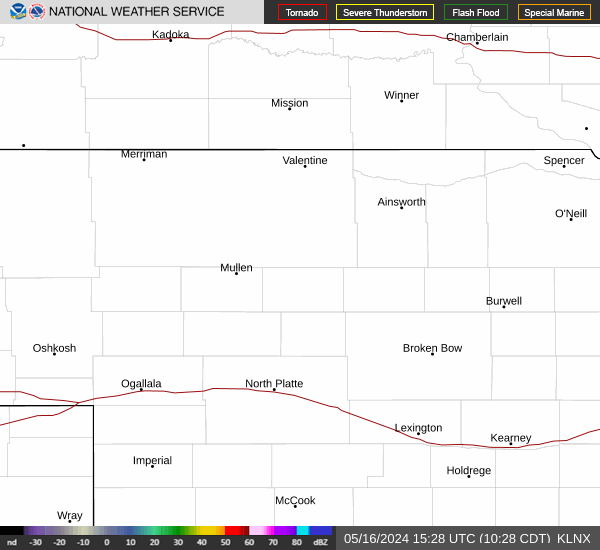 |
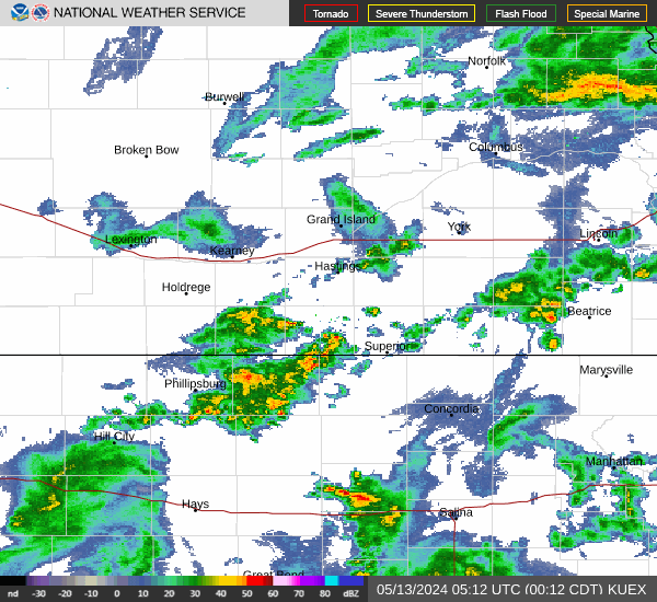 |
| Sioux Falls Radar | Des Moines Radar |
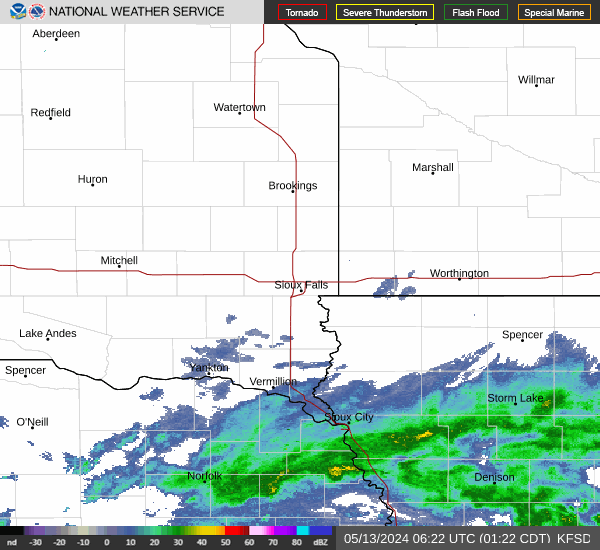 |
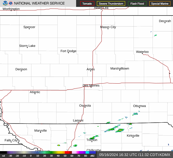 |
| Topeka Radar | Pleasant Hill Radar |
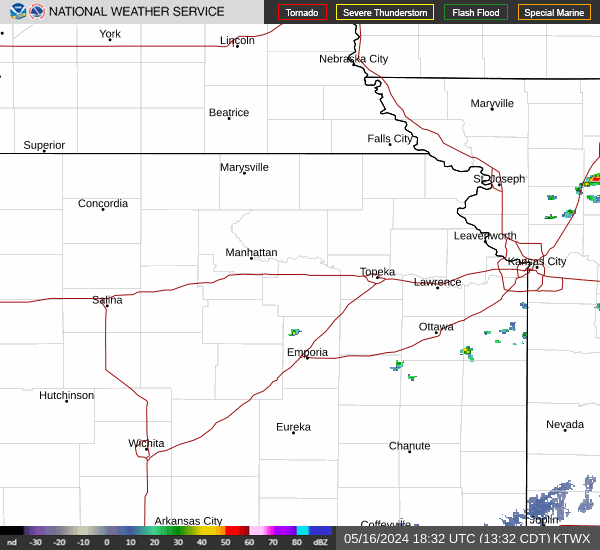 |
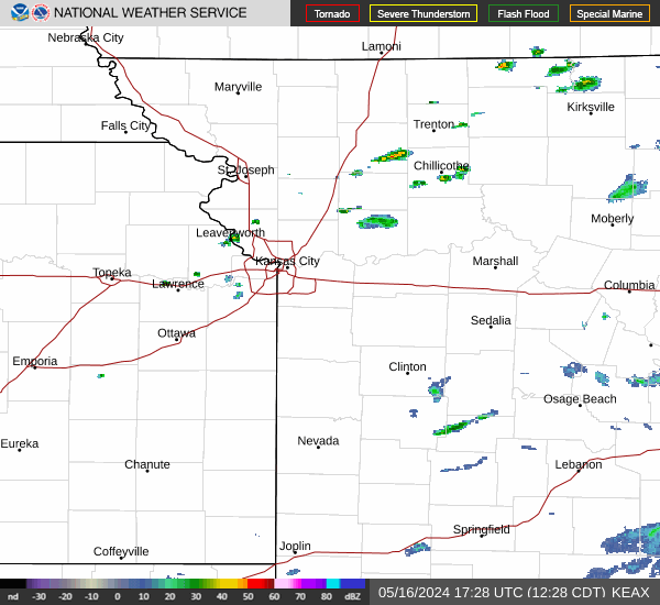 |
| Day 1 Outlook | Day 1 Tornado | Day 1 Wind | Day 1 Hail |
 |
 |
 |
 |
| Day 2 Outlook | Day 2 Probabilistic | Day 3 Outlook | Day 3 Probabilistic |
 |
 |
 |
 |
| Day 1 WFO Scale | Day 1 NE Scale | Day 1 IA Scale | Day 1 FEMA Scale |
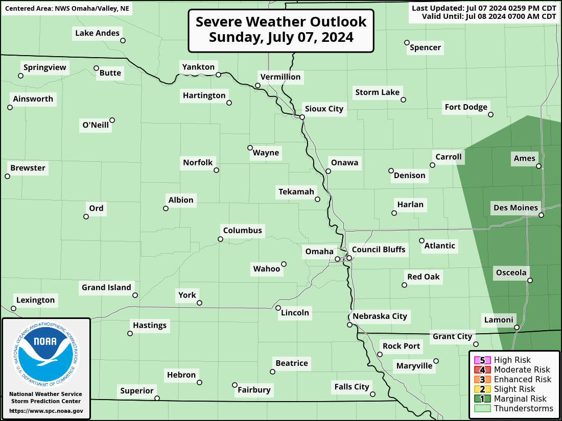 |
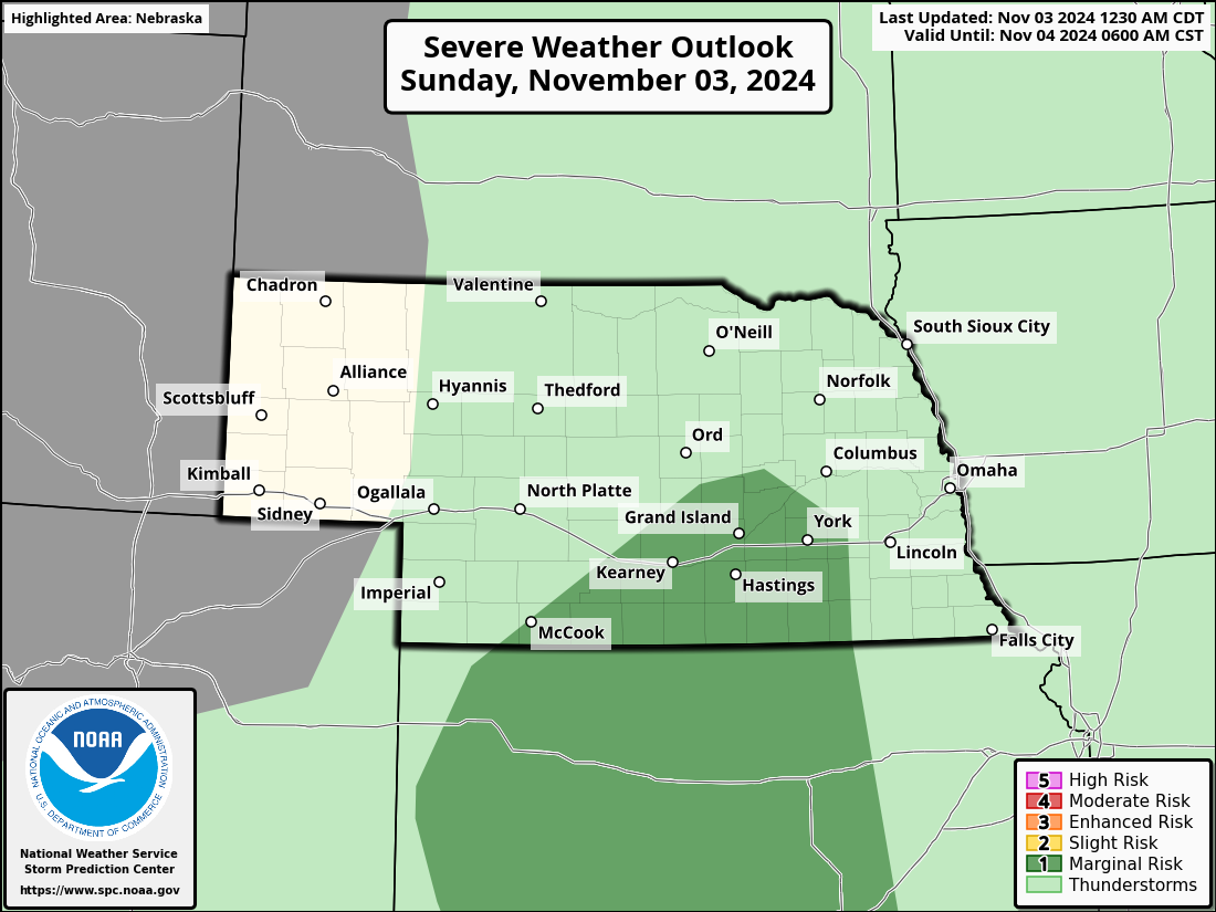 |
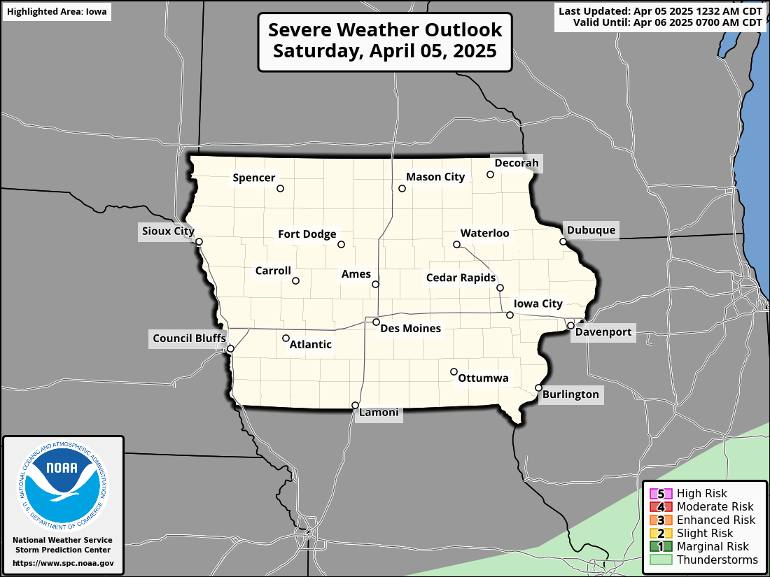 |
 |
| Day 2 WFO Scale | Day 2 NE Scale | Day 2 IA Scale | Day 2 FEMA Scale |
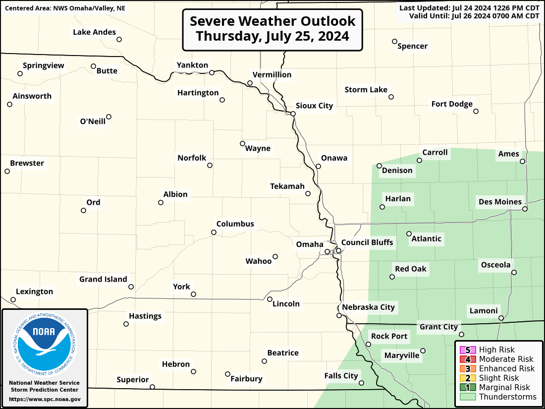 |
 |
 |
 |
| Day 3 WFO Scale | Day 3 NE Scale | Day 3 IA Scale | Day 3 FEMA Scale |
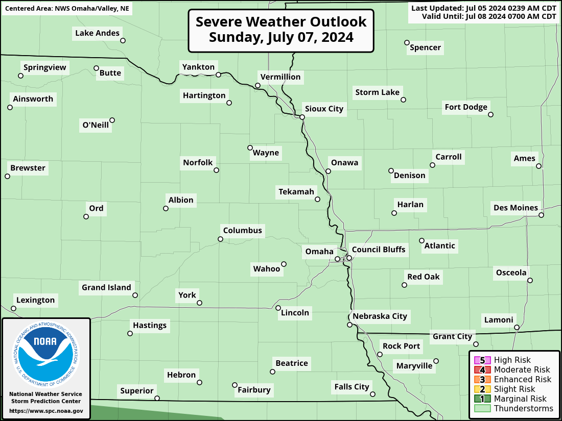 |
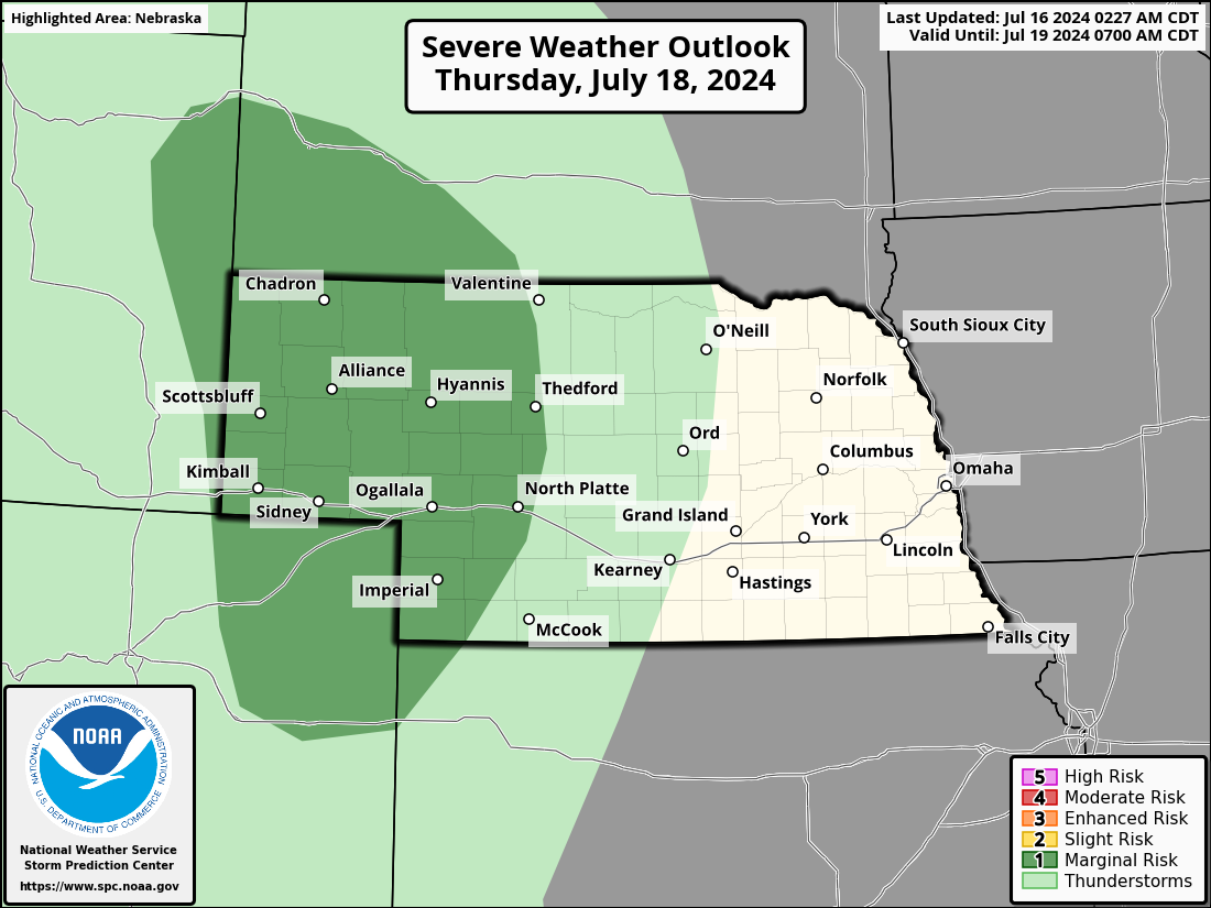 |
 |
 |
| Days 4-8 Outlook | MCDs | Today's Storm Reports | Yesterday's Reports |
 |
 |
 |
 |
| WWA | Current Watches | Reports in Last 3 Hours | |
 |
 |
 |
Day 1 Outlook
144
ACUS01 KWNS 161617
SWODY1
SPC AC 161616

Day 1 Convective Outlook
NWS Storm Prediction Center Norman OK
1116 AM CDT Wed Apr 16 2025

Valid 161630Z - 171200Z

...THERE IS A MARGINAL RISK OF SEVERE THUNDERSTORMS LATE THIS
AFTERNOON INTO TONIGHT FROM THE TEXAS PANHANDLE TO NORTHEAST KANSAS
AND VICINITY...

...SUMMARY...
Isolated large hail and strong-severe outflow gusts are possible
this evening into tonight from parts of the southern and central
Plains into the lower to mid Missouri Valley.

...TX Panhandle to northeast KS and vicinity through tonight...
Upper ridging that currently extends from the southern Plains into
eastern Manitoba/northwest Ontario is forecast to shift eastward
throughout the period. This eastward shift will occur as a shortwave
trough drops south-southeastward through the Pacific
Northwest/northern Rockies, phasing with the upper low off the
southern/central CA Coast as it does. This evolution will result in
strengthening southwesterly flow aloft from the Southwest into the
central Plains, which in turn will foster a deepening lee surface
trough across the High Plains and eventual surface cyclogenesis over
the central High Plains.

Moisture return will also increase across the southern Plains, with
upper 50s/low 60s dewpoints likely across much of OK by this
evening. Some thunderstorm development could occur during the late
afternoon/early evening where the western edge of this moisture
interacts with a dryline that extends south from the developing
central High Plains surface low. Convergence along this boundary
will be modest and convective initiation remains uncertain given the
warm mid-level temperatures and resultant capping. Even so, an
isolated storm or two appears possible from southwest KS into the
eastern TX Panhandle. Strong mid-level flow (and resulting long
hodographs) support a supercellular storm mode with any convection
that is also to deepen and persist. Large hail and damaging gusts
would be possible with any supercells.

Higher thunderstorm coverage is anticipated later tonight as the
surface low and any afternoon storms move eastward across
southwest/south-central KS into the greater low-level moisture, and
a strengthening low-level jet fosters increased warm-air advection.
Hail will likely be the primary risk with these storms, but the dry
subcloud layer in place could still support a few gusts to the
surface as well. Overall severe coverage is still expected to remain
low enough to keep 5%/Marginal probabilities.

..Mosier/Weinman.. 04/16/2025

$$
| Day 1 QPF | Day 2 QPF | Day 3 QPF |
 |
 |
 |
| Day 1 Excessive Rain | Day 2 Excessive Rain | Day 3 Excessive Rain |
 |
 |
 |
Day 1 Excessive Rain OAX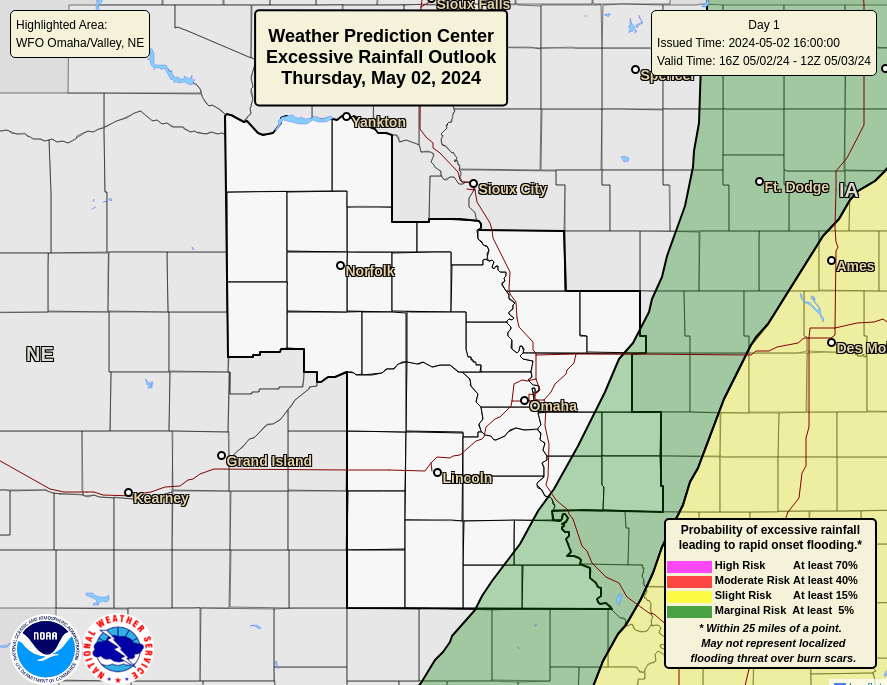 |
Day 2 Excessive Rain OAX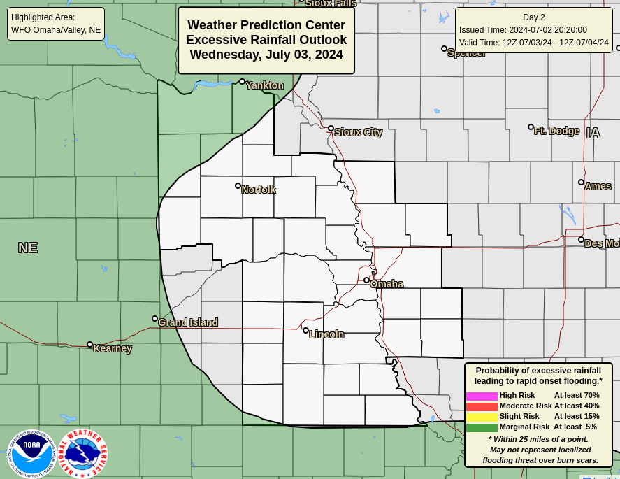 |
Day 3 Excessive Rain OAX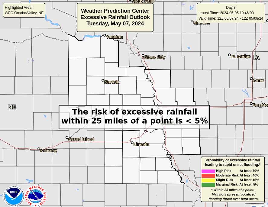 |
Day 1 Excessive Rain NE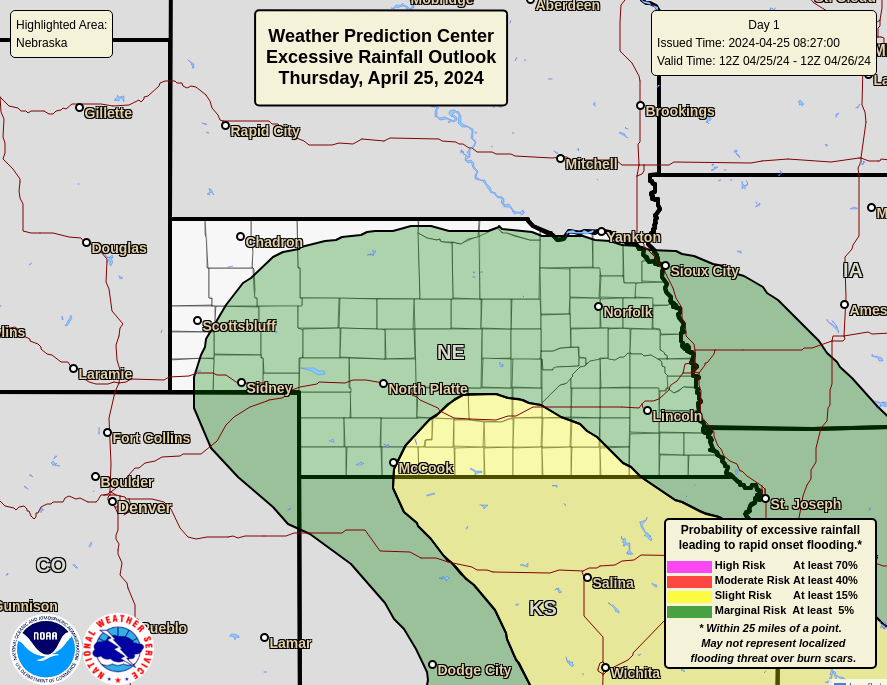 |
Day 2 Excessive Rain NE |
Day 3 Excessive Rain NE |
Day 1 Excessive Rain IA |
Day 2 Excessive Rain IA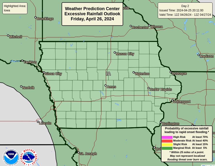 |
Day 3 Excessive Rain IA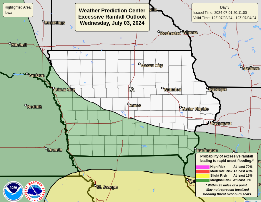 |
Day 1 Excessive Rain FEMA 7 |
Day 2 Excessive Rain FEMA 7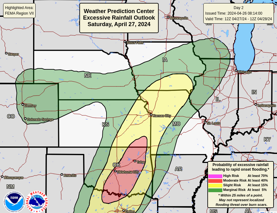 |
Day 3 Excessive Rain FEMA 7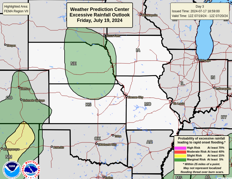 |
| Day 4/5 QPF | 5 Day Total QPF | Day 6/7 QPF |
 |
 |
 |
| 6-10 Day Temperature | 8-14 Day Temperature | 3-4 Week Temperature |
 |
 |
 |
| 6-10 Day Precipitation | 8-14 Day Precipitation | 3-4 Week Precipitation |
 |
 |
 |
| Mid Month Temp | End of Month Temp | Three Month Temperature |
 |
 |
 |
| Mid Month Precipitation | End of Month Precipitation | Three Month Precipitation |
 |
 |
 |
| All Temperature | All Precipitation | |
 |
 |
|
| Drought Monitor | OAX Drought | Drought Outlook |
 |
 |
 |
| Nebraska Drought | Iowa Drought | Precip Needed |
 |
 |
 |
 |
 |
| Day 1 Snow(>= 4 inches) | Day 2 Snow(>= 4 inches) | Day 3 Snow(>= 4 inches) |
 |
 |
 |
| Day 1 Snow(>= 8 inches) | Day 2 Snow(>= 8 inches) | Day 3 Snow(>= 8 inches) |
 |
 |
 |
| Day 1 Snow(>= 12 inches) | Day 2 Snow(>= 12 inches) | Day 3 Snow(>= 12 inches) |
 |
 |
 |
| Day 1 Probability Ice (>= 1/4 inch) | Day 2 Probability Ice (>= 1/4 inch) | Day 3 Probability Ice (>= 1/4 inch) |
 |
 |
 |
Day 4
 |
Day 5
 |
Day 6 Snow |
Day 7 Snow
 |
Overall WSSI for OAX - Winter Storm Severity Index - Archive
|
|||||||||||||||||||||||||||||||||
|
Day 1 Snow
 |
Day 2 Snow
 |
Day 3 Snow |
Day 4 Snow
 |
Day 1 Ice
 |
Day 2 Ice
 |
Day 3 Ice |
Day 4 Ice
 |


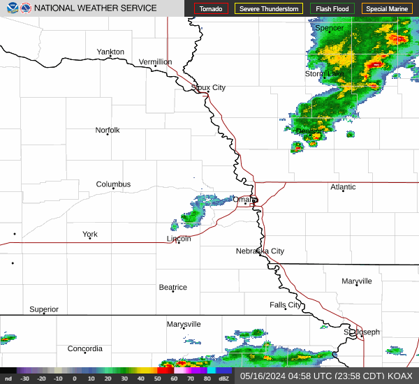
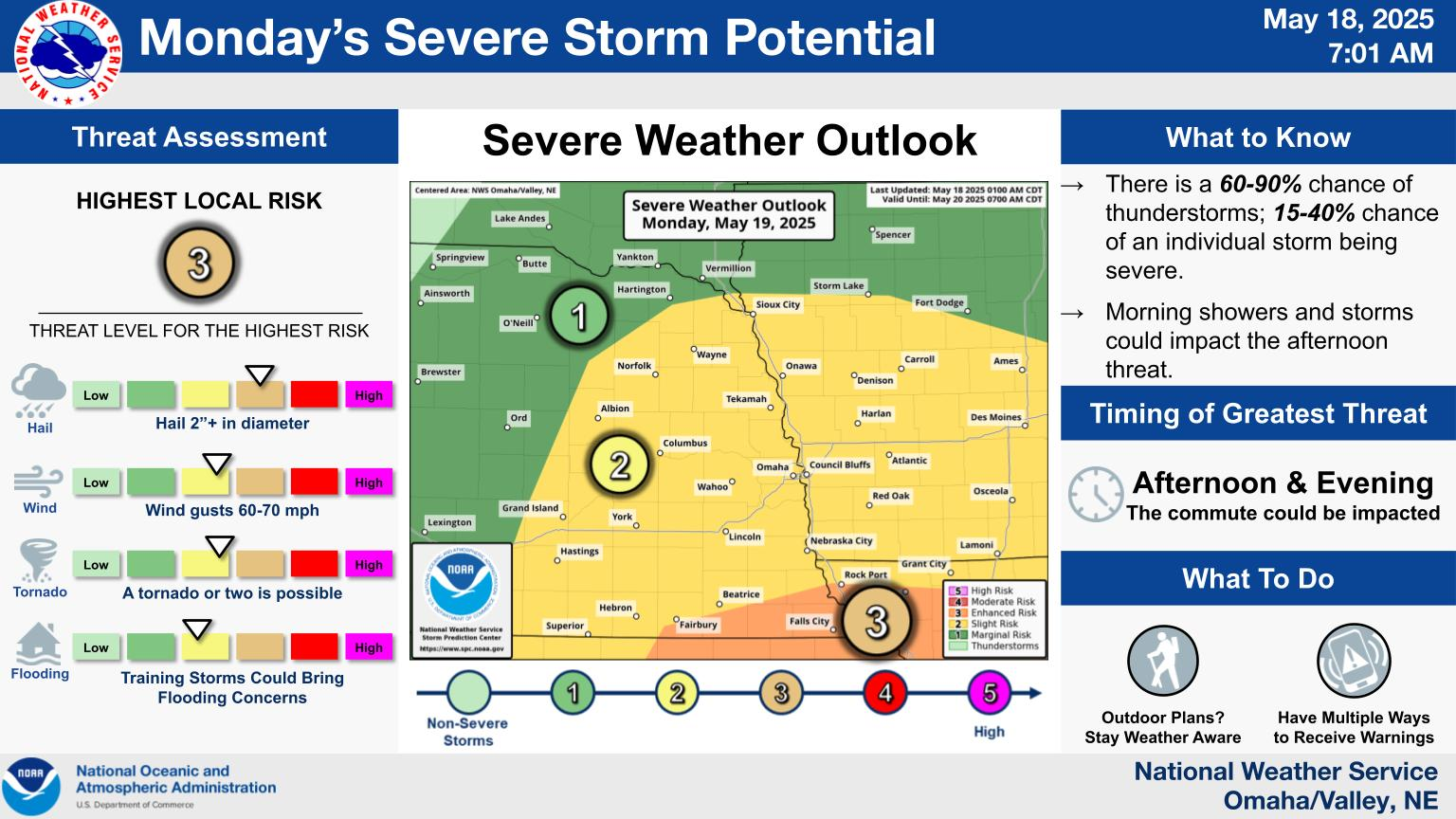

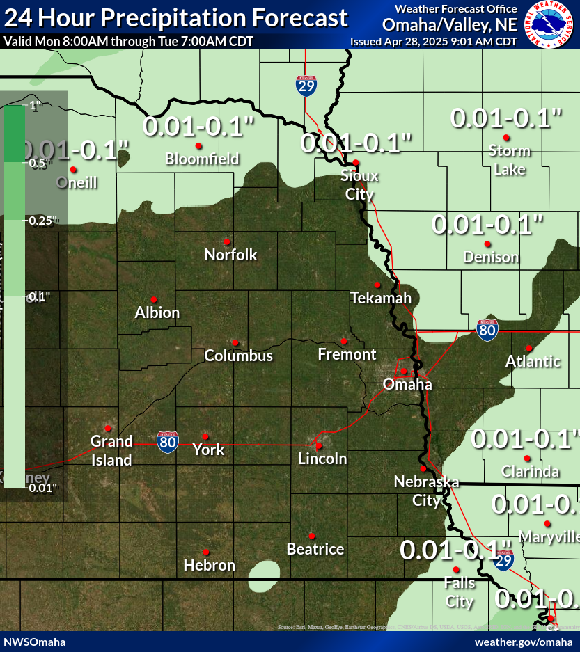


