A storm and trailing cold front will continue to slowly move through the Gulf Coast and Southeast U.S. through this weekend with widespread rain showers and isolated thunderstorms. A fast-moving clipper storm may bring several inches of snow to the north-central Plains, Midwest, eastern Great Lakes, and Northeast regions this weekend. Read More >
Overview
|
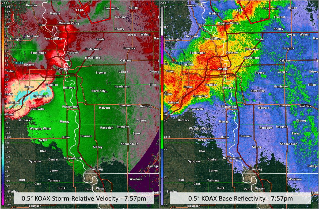
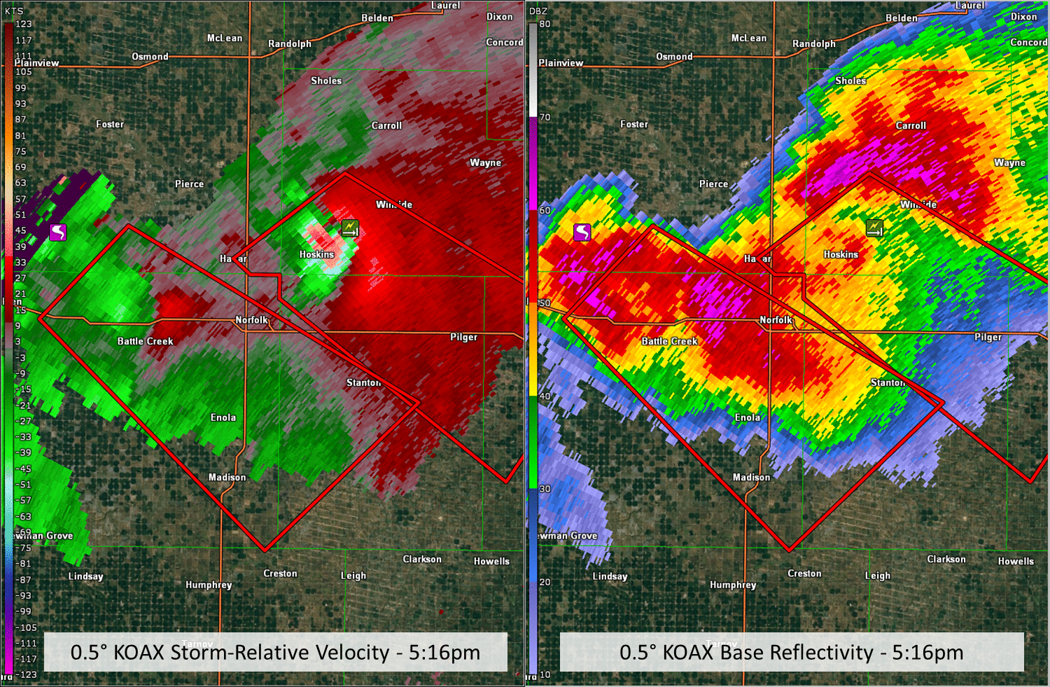
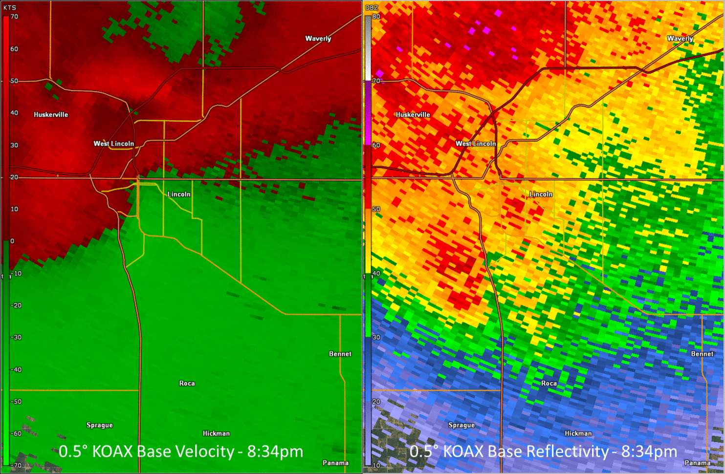
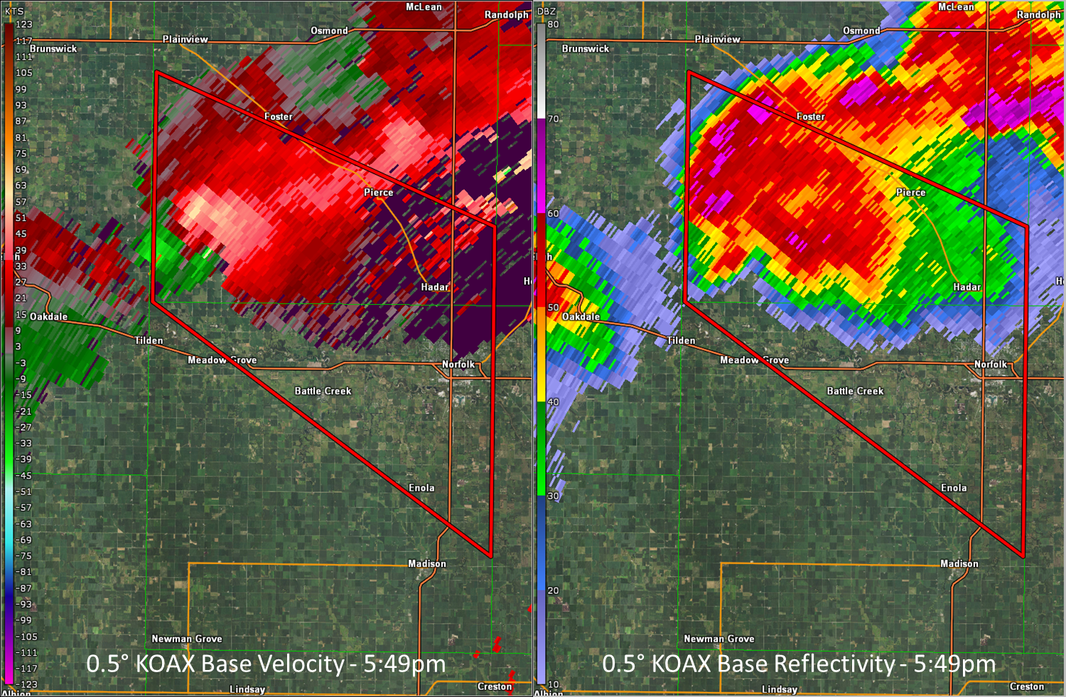
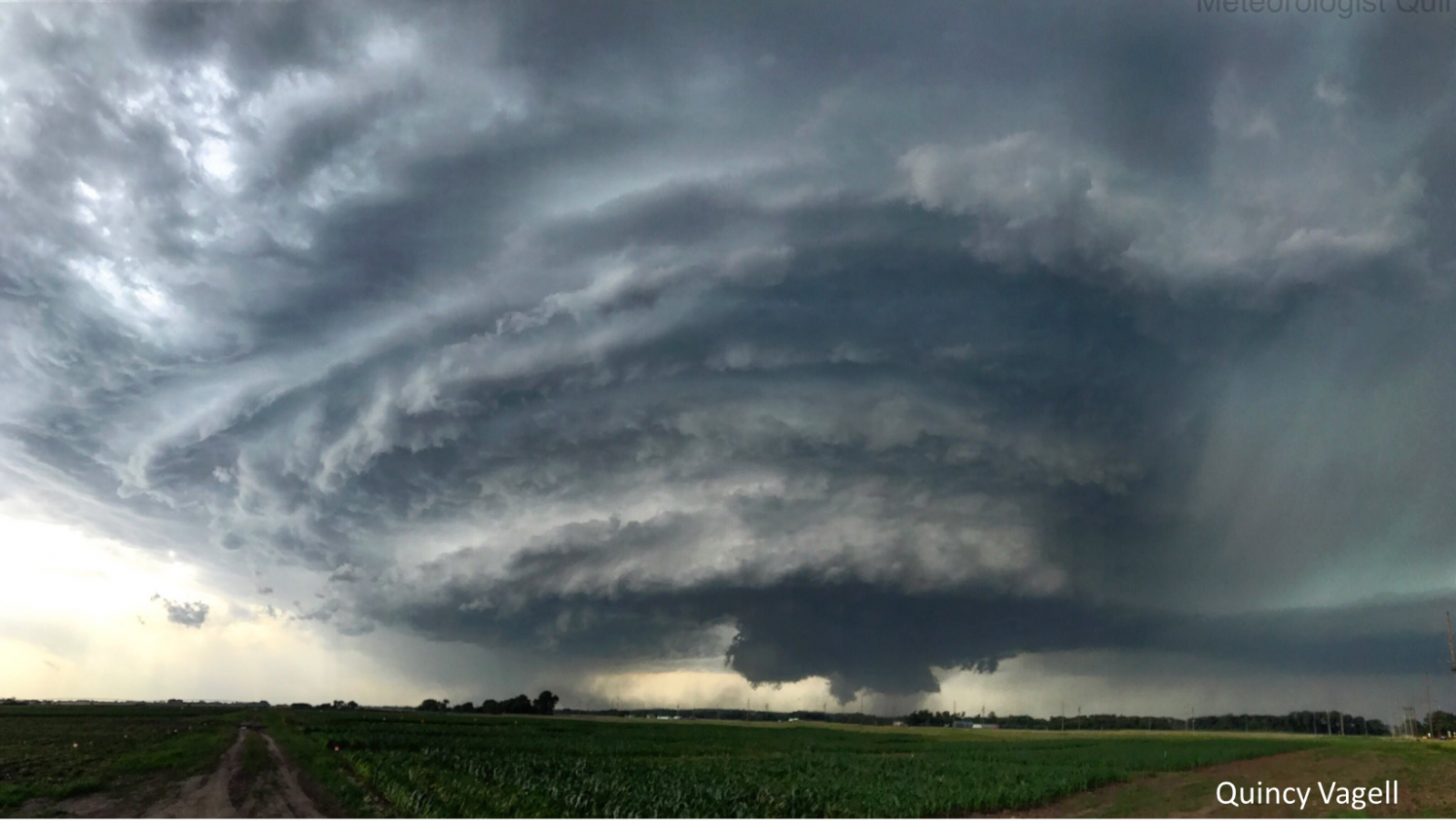
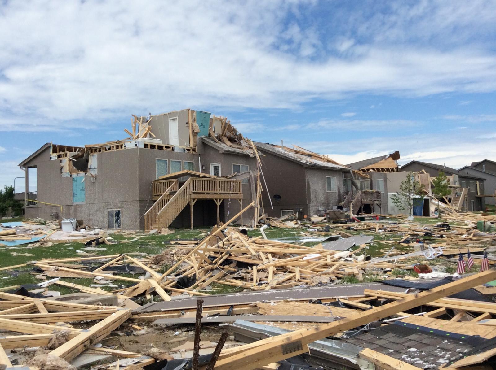
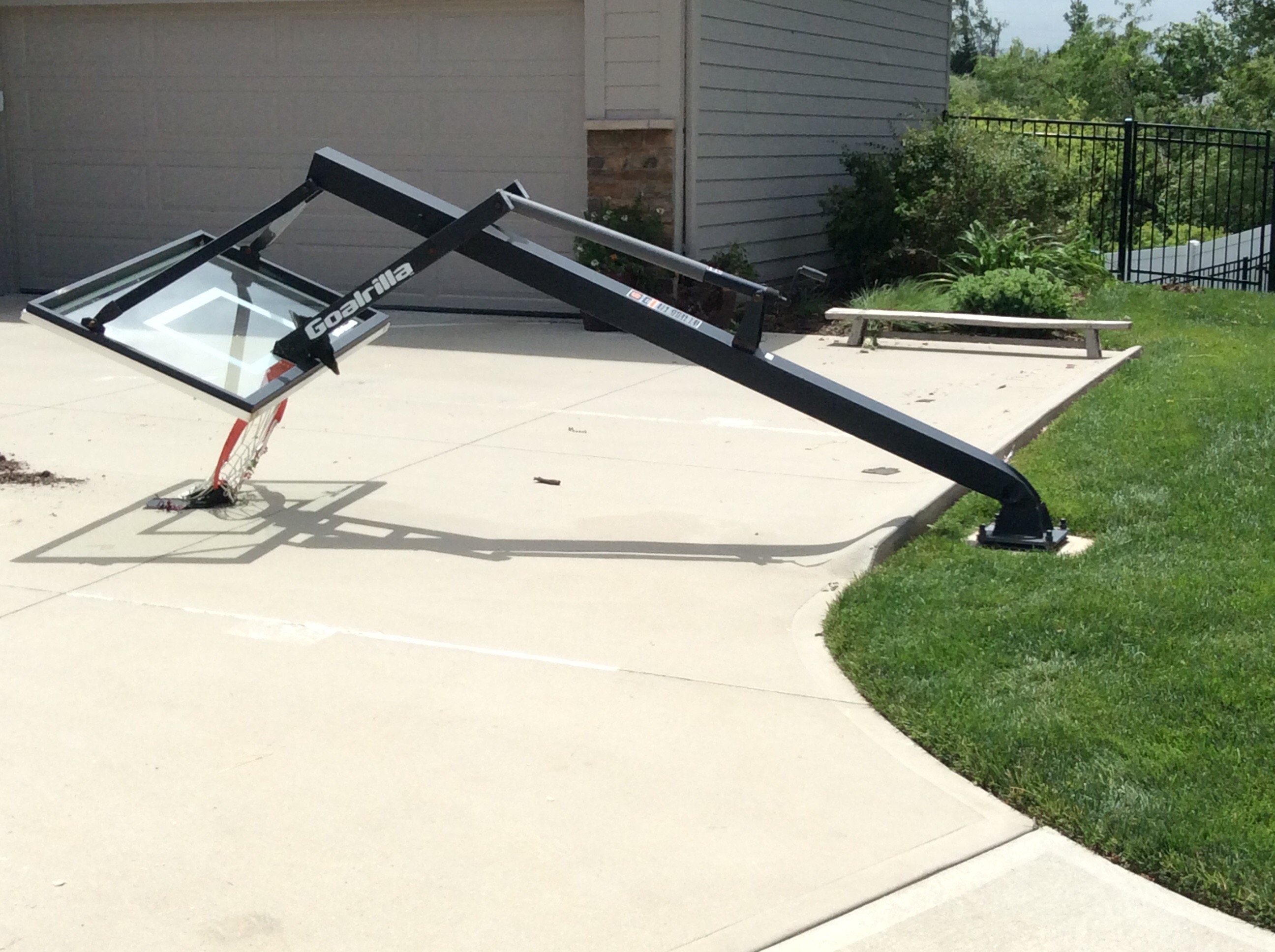
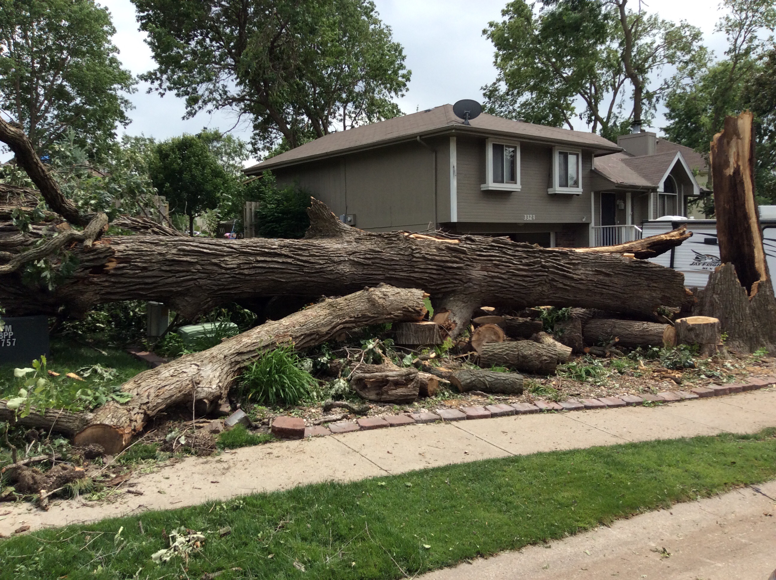
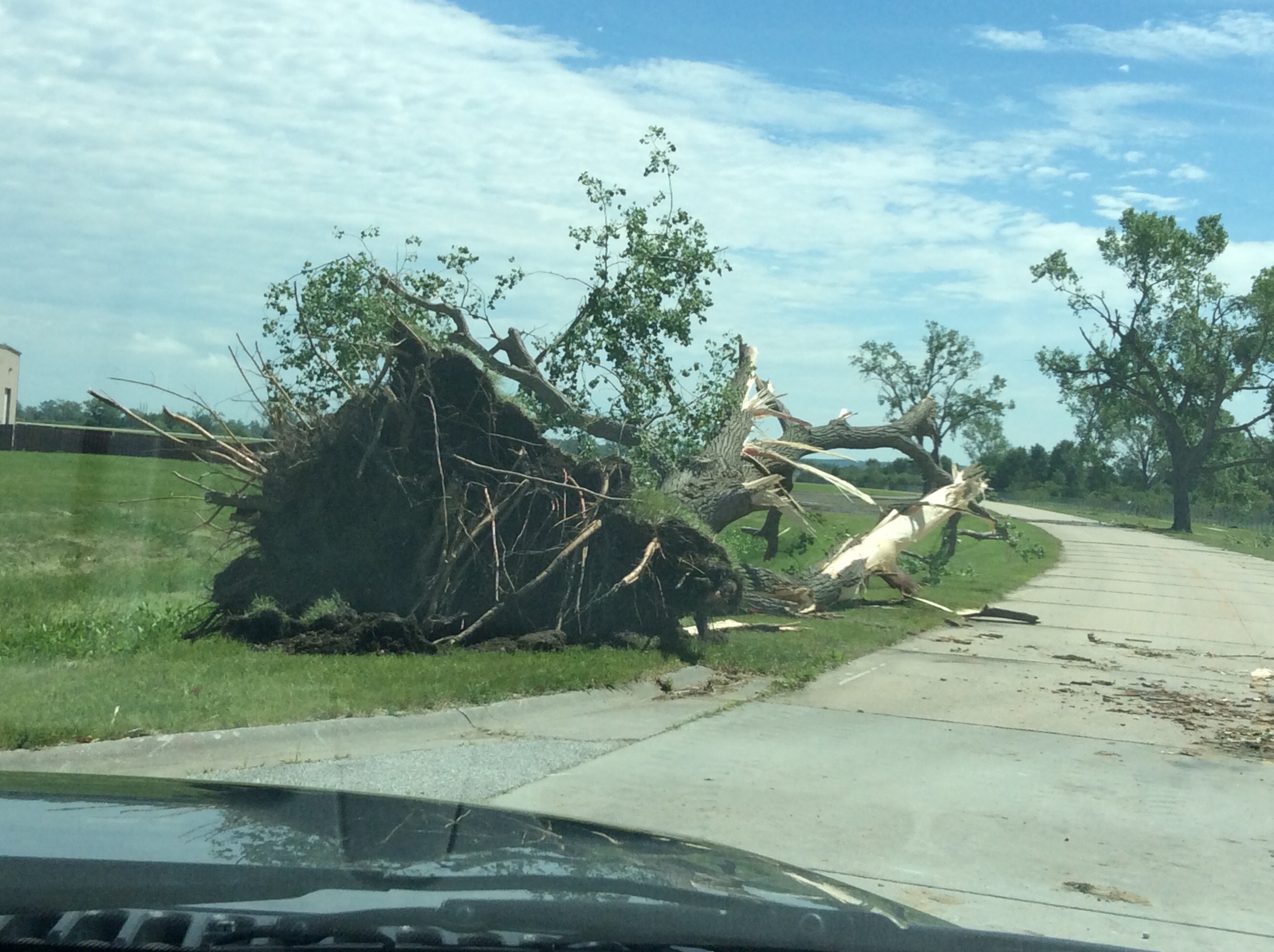
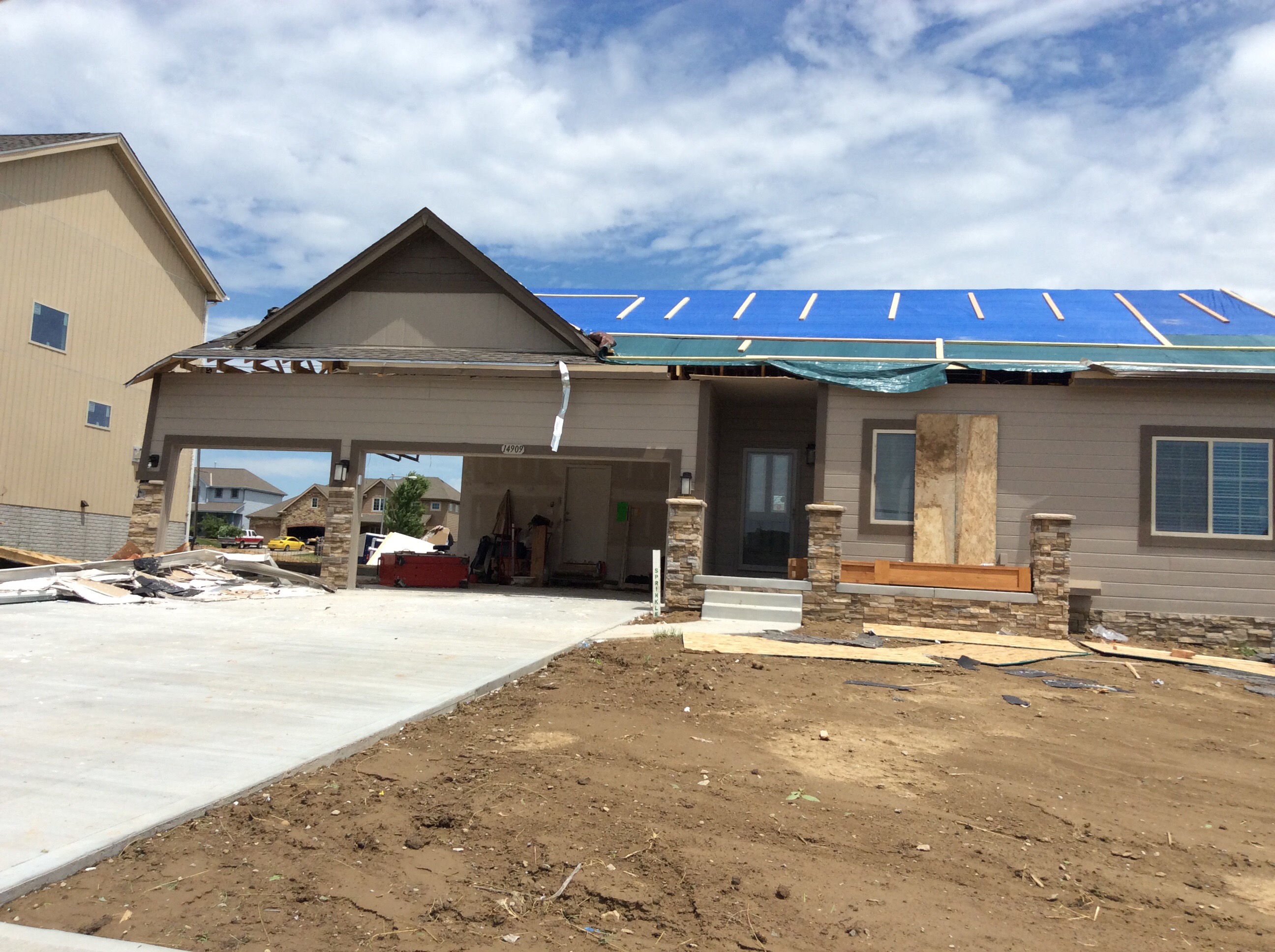
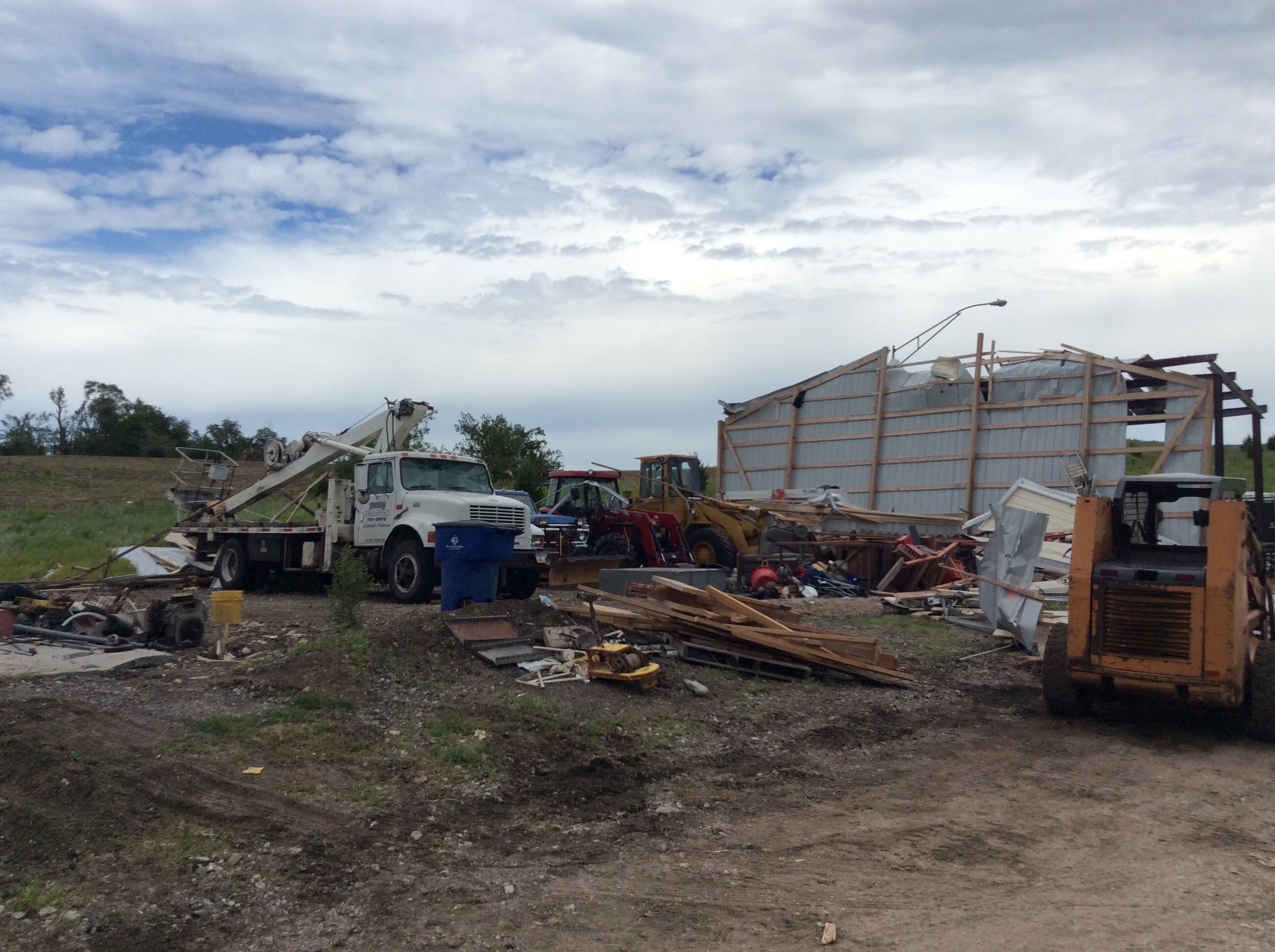
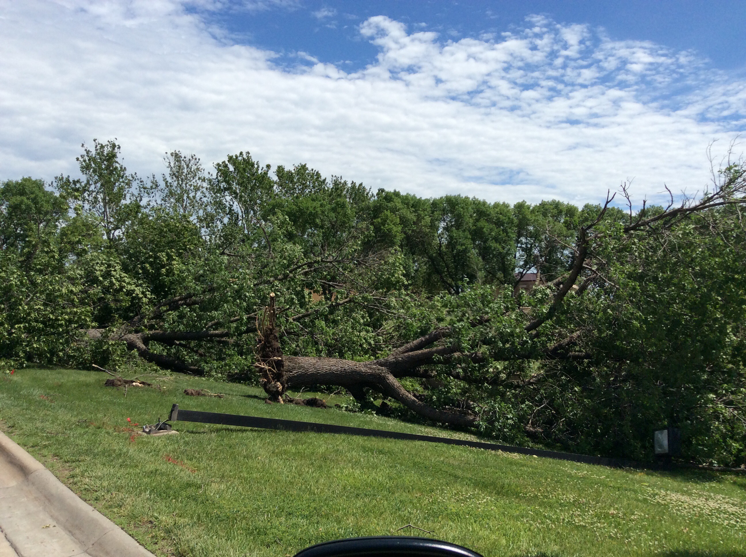
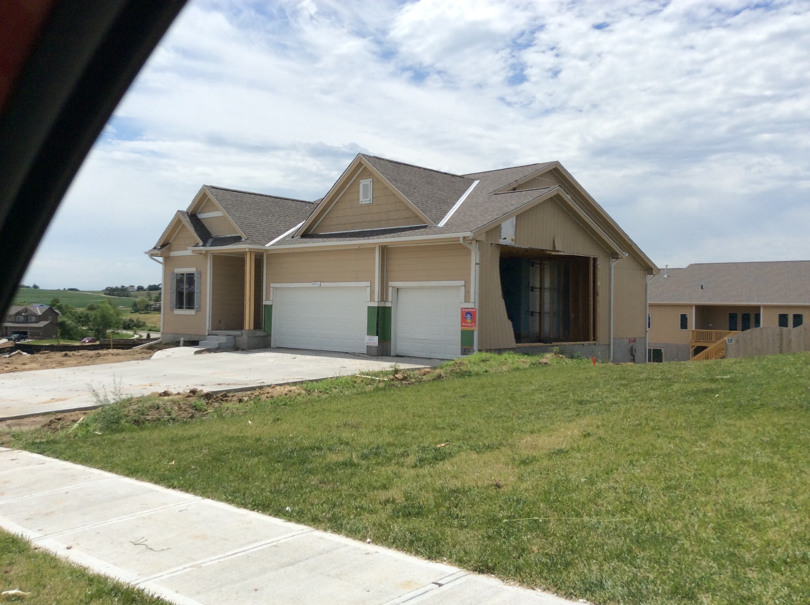
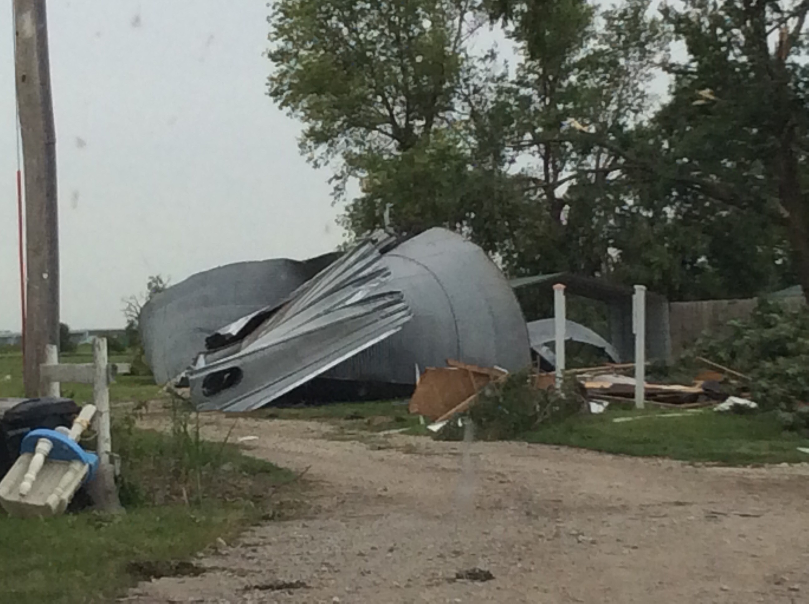
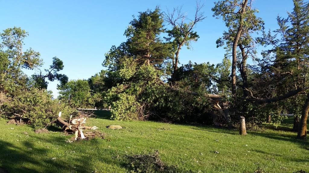
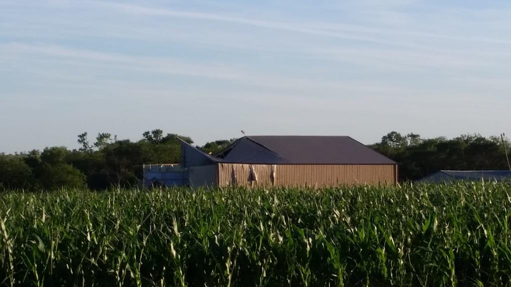
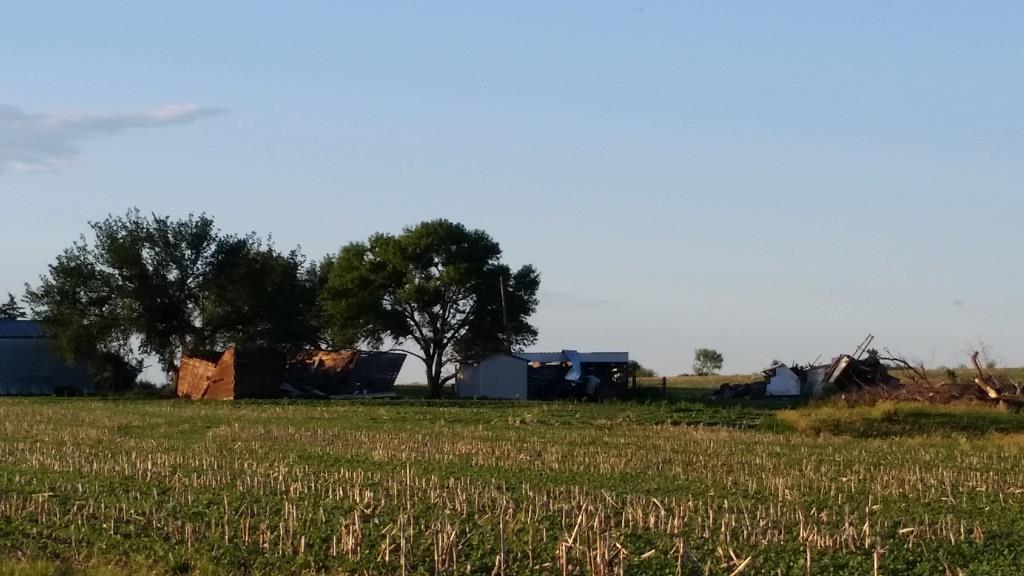
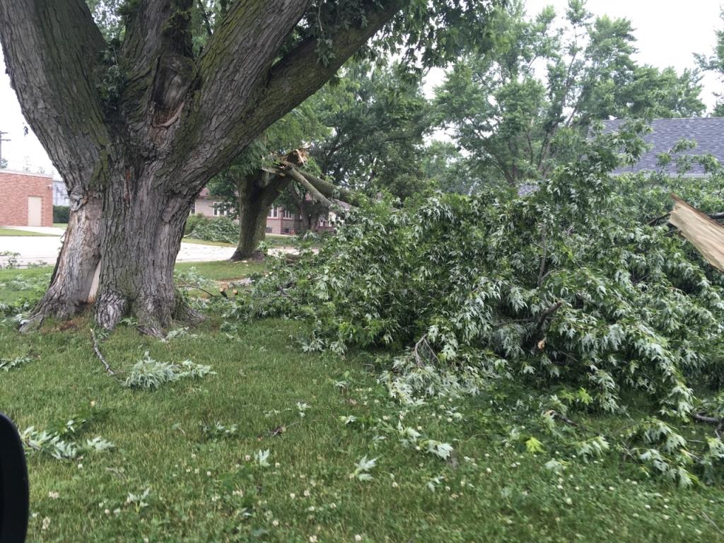
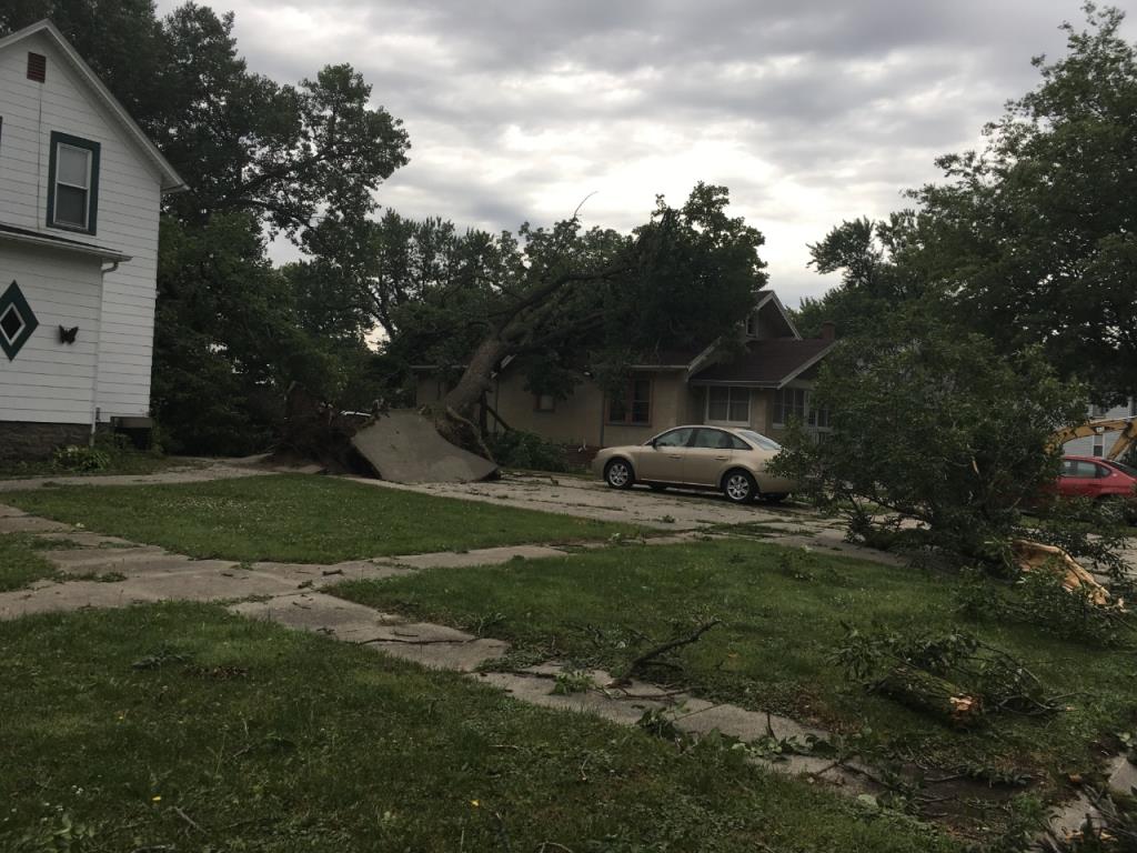
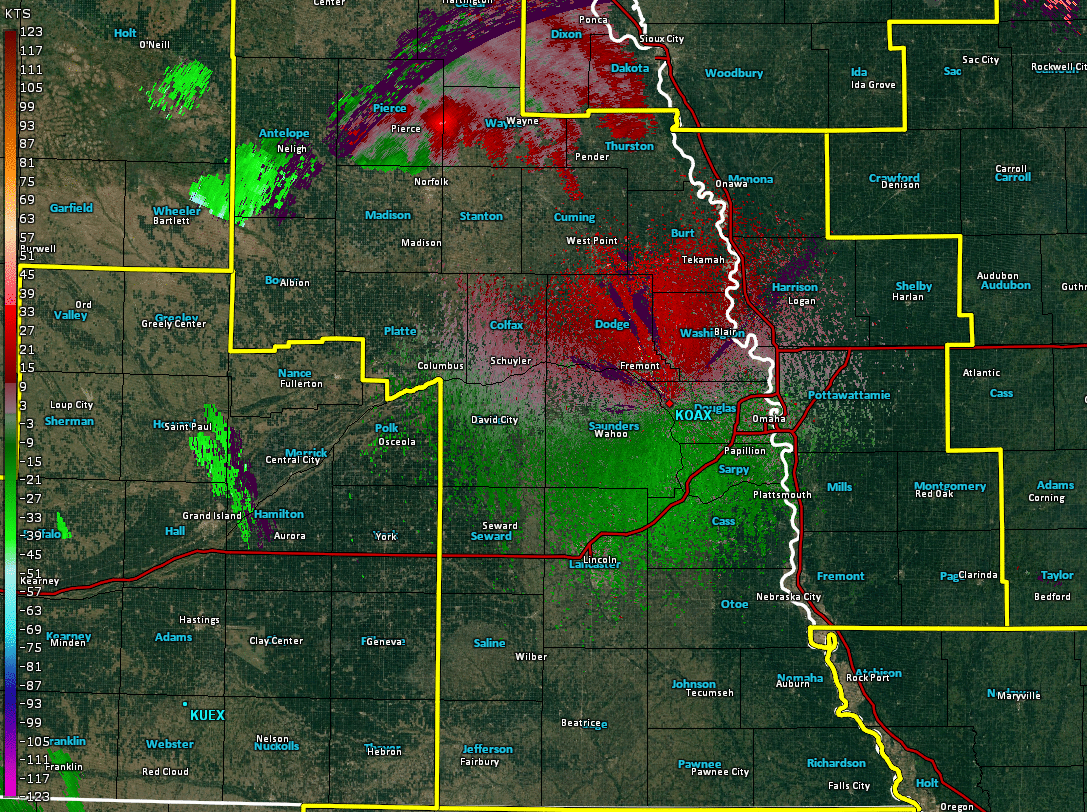
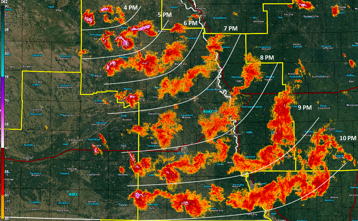
A line of intense supercell thunderstorms developed over northeast Nebraska during the afternoon hours of Friday, June 16. These storms progressed toward the south and east through the evening, progressively morphing into a sweeping line of storms with embedded areas of both supercells and intense bow echoes. While the entire line produced widespread reports of wind damage and hail across a large portion of southwest Iowa and eastern Nebraska, the most intense activity produced hurricane-force winds of 80-110 mph, hail larger than golf balls, and several tornadoes. Damage was reported in several counties across southwest Iowa and eastern Nebraska, with significant damage to homes impacted by tornadoes and widespread, substantial tree and crop damage.
|
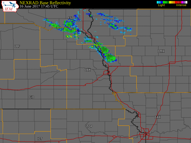 Radar Reflectivity Animation for the Event |
 |
 |
 |
| near Seward, Nebraska | near Battle Creek, Nebraska | near Bellevue, Nebraska |
Tornadoes:
|
|
||||||||||
|
||||||||||
|
Tornado #1 - Bellevue, Nebraska
Track Map 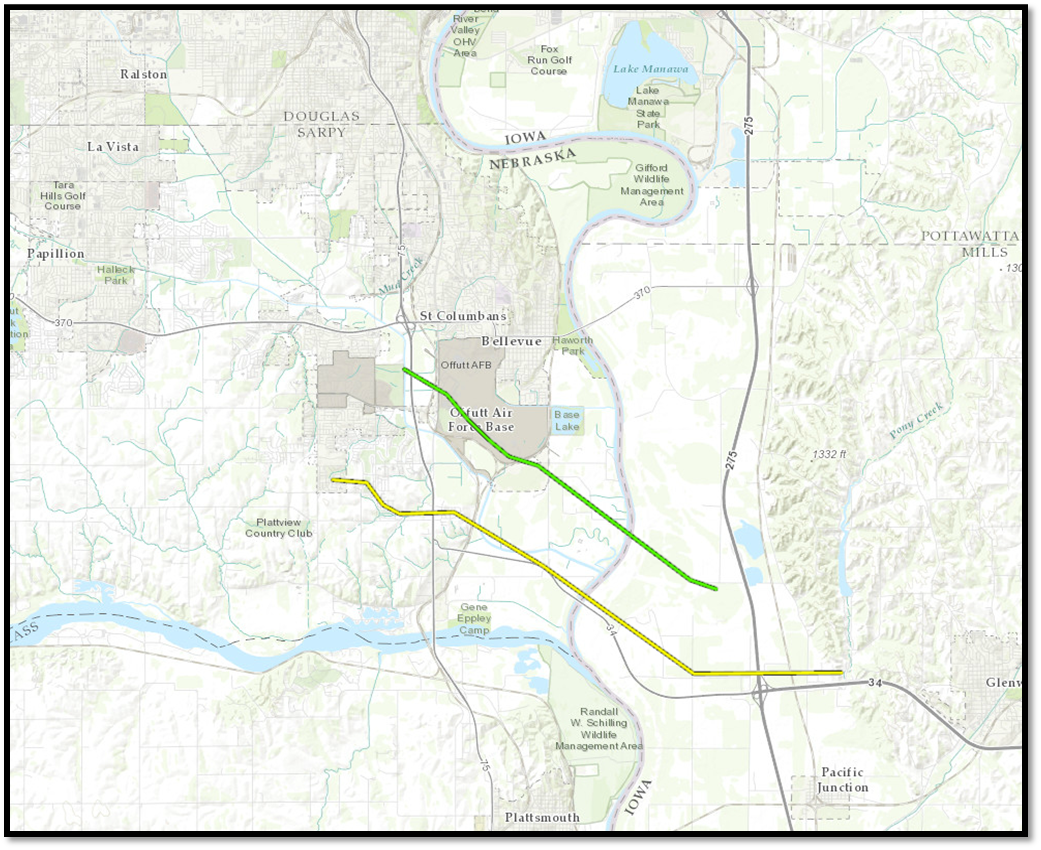  |
||||||||||||||||
|
||||||||||||||||
|
Tornado #2 - Offutt AFB, Nebraska
Track Map |
||||||||||||||||
|
||||||||||||||||
|
Tornado #3 - Hoskins, Nebraska
Track Map 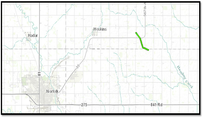 |
||||||||||||||||
|
||||||||||||||||
|
Tornado #4 - Madison, Nebraska
Track Map 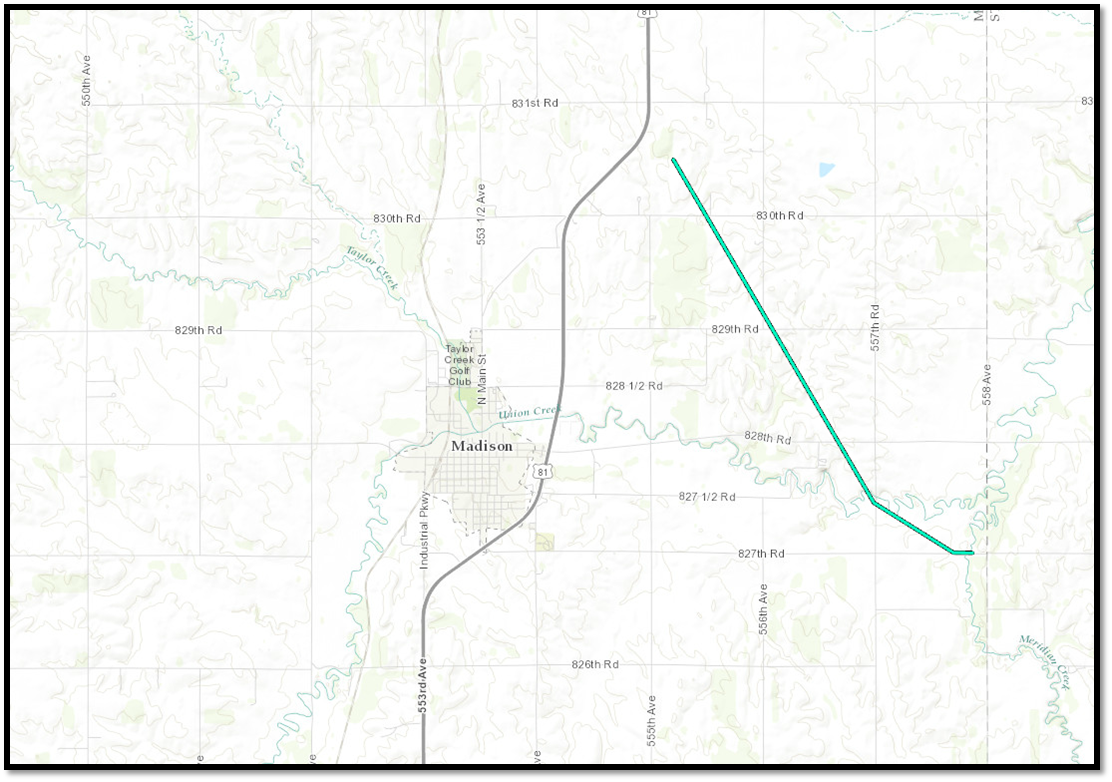 |
||||||||||||||||
|
||||||||||||||||
|
Tornado #5 - Lincoln, Nebraska
Track Map 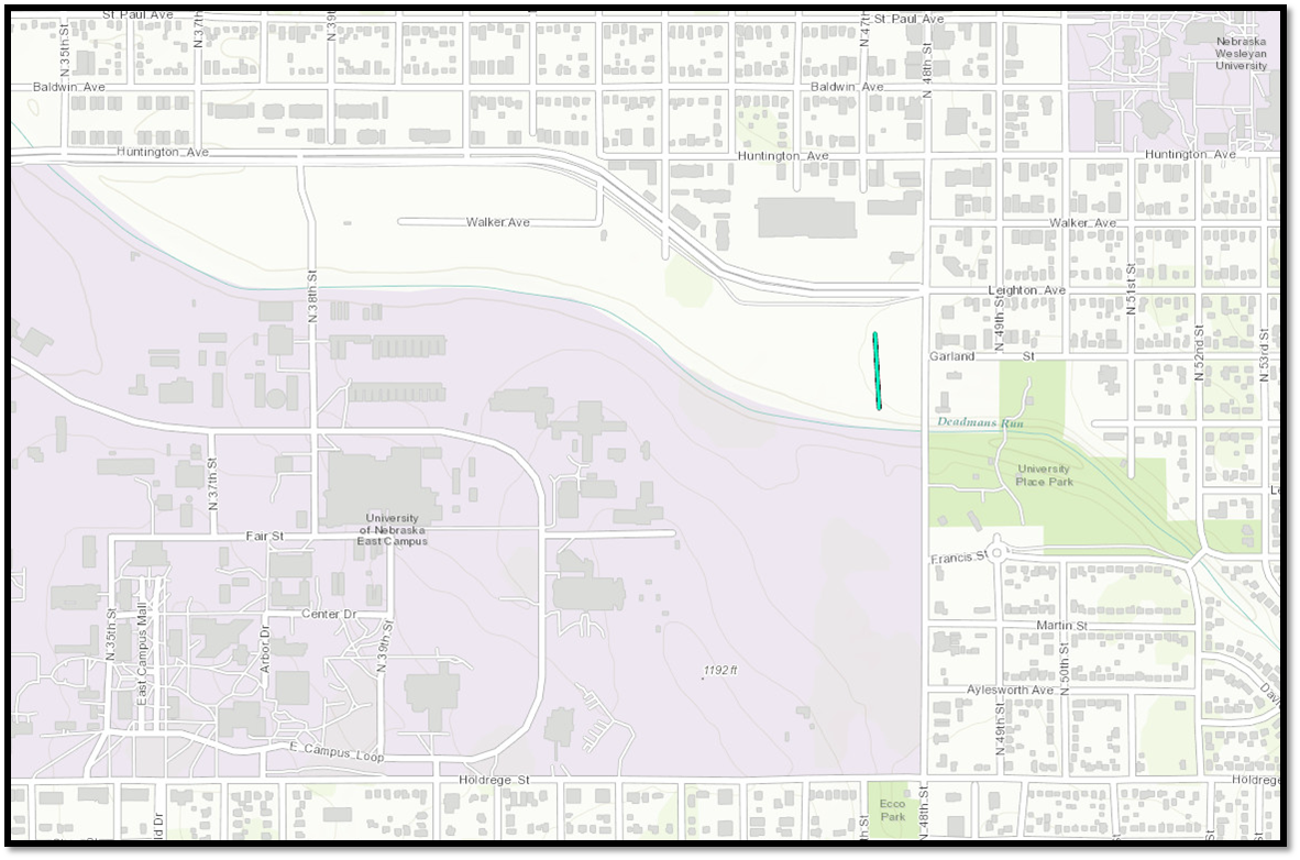 |
||||||||||||||||
|
||||||||||||||||
|
Tornado #6 - Meadow Grove, Nebraska
Track Map 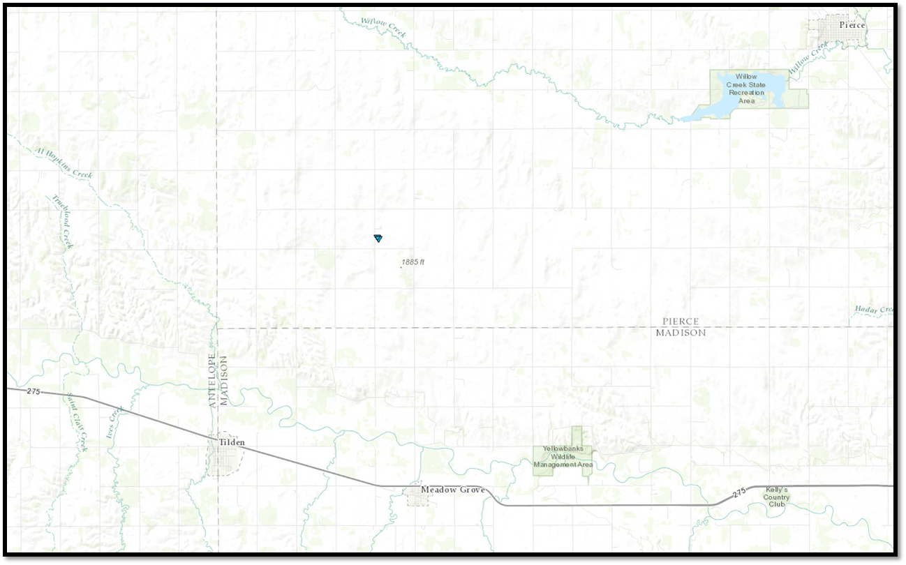 |
||||||||||||||||
|
||||||||||||||||
The Enhanced Fujita (EF) Scale classifies tornadoes into the following categories:
| EF0 Weak 65-85 mph |
EF1 Moderate 86-110 mph |
EF2 Significant 111-135 mph |
EF3 Severe 136-165 mph |
EF4 Extreme 166-200 mph |
EF5 Catastrophic 200+ mph |
 |
|||||
Wind & Hail:
Public Information Statement
National Weather Service Omaha/Valley NE
908 AM CDT Wed Jun 21 2017

...NWS DAMAGE SURVEY FOR JUNE 16, 2017 SEVERE THUNDERSTORM WIND
EVENT...

.Southern Sarpy County and Surrounding Areas Wind Damage...

Peak wind:              110-120 mph based on damage indicators
Direction:              From the Northwest
Fatalities:             0
Injuries:               0

Start date:             June 16, 2017
Start time:             7:40 PM CDT

End date:               June 16, 2017
End time:               8:30 PM CDT

A powerful group of thunderstorms produced widespread winds of 60 to
80 mph across much of the area surrounding southern Sarpy county.
Within that broad area of wind, several areas of very intense wind
damage occurred with damage indicators suggesting peak wind speeds
of 100 to 120 mph from the north and northwest.

Perhaps the most intense damage was noted from approximately 3 miles
northwest of Springfield to just west of Springfield to 3 miles south
of Springfield where very large grain bins were dislodged and tumbled
nearly a half mile, many power poles were snapped, and widespread
significant tree damage occurred. Peak winds in this area were likely
in the 110-120 mph range.

Another area of more intense damage occurred in and near the Maha Scout
Camp at 63rd street and the Platte River. Tree damage in this area
indicated smaller areas of locally intense microburst winds which likely
approached 110 mph. Approximately 50 campers were present during the
storm with no injuries reported.

Additional areas of very intense winds occurred in southeast Sarpy county
and adjacent northeast Cass county and western Mills county Iowa to the
south of the EF-2 tornado track. Winds in these areas likely exceeded
100 mph.

Special thanks to local emergency management for assisting NWS storm
damage survey efforts for this expansive severe weather event.

.Gage County and Southeast Saline County Wind Damage...

Peak wind:              100-115 mph based on damage indicators
Direction:              From the North and Northwest
Fatalities:             0
Injuries:               0

Start date:             June 16, 2017
Start time:             8:50 PM CDT

End date:               June 16, 2017
End time:               10:10 PM CDT

A very intense supercell thunderstorm tracked from eastern Saline county
southeast across Gage county. This storm produced 60-80 mph winds
throughout much of its track with a narrower band of 80-115 mph winds
associated with the western rear flank downdraft portion of the storm.
These most intense winds tracked from near Wilber to De Witt to west
Beatrice to Big Indian Creek Reservoir. Damage indicators and radar
data suggest that within this several-mile-wide track there were strong
pulses of wind which produced the most intense damage.

One of the most intense areas was on the southwest side of Wilber where
part of a roof was removed and blown more than 100 yards and a storm
spotter truck was blown sideways approximately 3 feet. Another area of
more intense damage was on the far west side of Beatrice where
substantial tree damage occurred as well as some roof damage to homes
and businesses. The final area of very intense damage occurred
approximately 3 miles northwest of Blue Springs where a barn was
destroyed, the roof of a large shed caved in, several power poles were
snapped, and significant tree damage occurred.

Special thanks to local emergency management for assisting NWS storm
damage survey efforts for this expansive severe weather event.

NOTE:
The information in this statement is PRELIMINARY and subject to
change pending final review of the events and publication in
NWS Storm Data.
 |
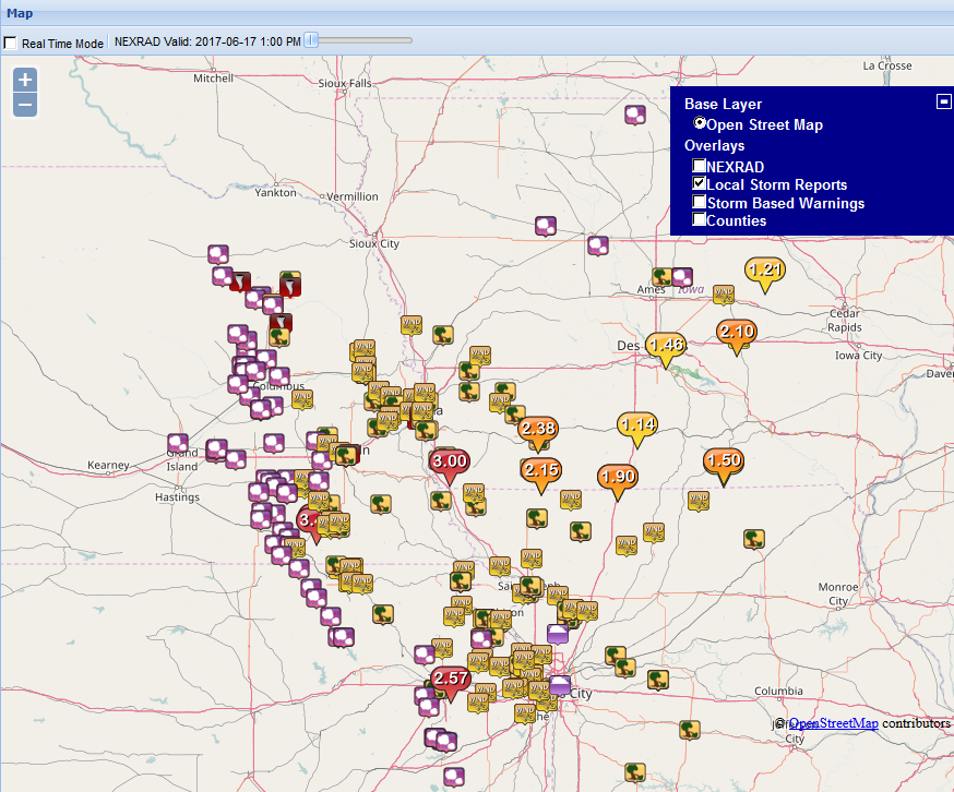 |
| Wind, Hail and Tornado Reports (from the SPC) |
PUBLIC INFORMATION STATEMENT
NATIONAL WEATHER SERVICE OMAHA/VALLEY NE
253 AM CDT SAT JUN 17 2017

..WIND REPORTS

LOCATION                     SPEED     TIME/DATE       LAT/LON/COMMENTS
2 NW FREMONT                110 MPH    0725 PM 06/16   MEASURED(CHASER)
OMAHA                       104 MPH    0725 PM 06/16   MEASURED(SPOTTER)
LINCOLN AIRPORT              87 MPH    0837 PM 06/16   40.85N/96.76W
VALLEY NWS                   87 MPH    0736 PM 06/16   MEASURED
BEATRICE AIRPORT             85 MPH    0955 PM 06/16   40.30N/96.75W
HOOPER                       80 MPH    0710 PM 06/16   ESTIMATED(SPOTTER)
BELLEVUE                     80 MPH    0810 PM 06/16   ESTIMATED(PUBLIC)
5 W BEATRICE                 80 MPH    0934 PM 06/16   MEASURED(SPOTTER)
2 WNW WEST POINT             74 MPH    0635 PM 06/16   41.85N/96.75W
NORFOLK AIRPORT              74 MPH    0538 PM 06/16   41.99N/97.43W
4 SSW GRETNA                 74 MPH    0779 PM 06/16   MEASURED
2 ENE AVOCA                  70 MPH    0850 PM 06/16   41.50N/95.29W
MALCOLM                      70 MPH    0835 PM 06/16   ESTIMATED(AMRADIO)
3 W MILLARD                  67 MPH    0800 PM 06/16   41.20N/96.22W
4 E NEBRASKA CITY            66 MPH    0902 PM 06/16   40.69N/95.78W
WILBER                       65 MPH    0913 PM 06/16   MEASURED(CHASER)
4 S DORCHESTER               63 MPH    0857 PM 06/16   MEASURED(CHASER)
HARLAN AIRPORT               62 MPH    0835 PM 06/16   41.59N/95.34W
OMAHA EPPLEY AIRFIELD        60 MPH    0804 PM 06/16   41.30N/95.89W
2 WSW FAIRBURY               58 MPH    1157 PM 06/16   40.13N/97.21W
GRETNA (4 ENE)               55 MPH    0757 PM 06/16   POWER WENT OUT
HARBINE                      55 MPH    0812 PM 06/16   40.19N/96.98W
MILLARD                      54 MPH    0759 PM 06/16   41.21N/96.17W
2 WSW OFFUTT AFB             53 MPH    0803 PM 06/16   41.10N/95.96W
1 S WASHINGTON               53 MPH    0755 PM 06/16   41.37N/96.21W
FREMONT AIRPORT              52 MPH    0715 PM 06/16   41.45N/96.52W
2 N FIRTH                    51 MPH    0915 PM 06/16   40.57N/96.61W
4 NNE MEMPHIS                51 MPH    0800 PM 06/16   41.16N/96.41W
4 WSW KENNARD                50 MPH    0725 PM 06/16   41.44N/96.27W
MILLARD AIRPORT              49 MPH    0755 PM 06/16   41.20N/96.12W
BLAIR AIRPORT                48 MPH    0755 PM 06/16   41.41N/96.11W
3 E FRIEND                   48 MPH    0849 PM 06/16   40.66N/97.22W
PISGAH                       48 MPH    0811 PM 06/16   41.83N/95.93W
NEBRASKA CITY AIRPORT        47 MPH    0915 PM 06/16   40.61N/95.87W
1 WNW DUNCAN                 47 MPH    0715 PM 06/16   41.40N/97.52W
OMAHA                        46 MPH    0814 PM 06/16   41.26N/96.01W
CLARINDA AIRPORT             46 MPH    0935 PM 06/16   40.72N/95.03W
3 E PLYMOUTH                 46 MPH    0935 PM 06/16   40.31N/96.93W
WAHOO AIRPORT                44 MPH    0730 PM 06/16   41.23N/96.60W
RED OAK AIRPORT              43 MPH    0855 PM 06/16   41.01N/95.26W
5 SSW BLENCOE                43 MPH    0650 PM 06/16   41.87N/96.10W
2 ENE GRETNA                 42 MPH    0755 PM 06/16   41.16N/96.19W
3 E JULIAN                   41 MPH    0915 PM 06/16   40.53N/95.80W
2 S MURRAY                   41 MPH    0820 PM 06/16   40.89N/95.93W
JULIAN                       40 MPH    0927 PM 06/16   40.51N/95.86W
COUNCIL BLUFFS AIRPORT       39 MPH    0815 PM 06/16   41.26N/95.76W
2 ESE OMAHA                  39 MPH    0810 PM 06/16   41.24N/95.97W
TEKAMAH AIRPORT              39 MPH    0716 PM 06/16   41.76N/96.18W
5 N ROCA                     38 MPH    0847 PM 06/16   40.73N/96.67W
SHENANDOAH AIRPORT           38 MPH    0855 PM 06/16   40.77N/95.41W
ALBION AIRPORT               37 MPH    0555 PM 06/16   41.73N/98.06W
3 NNE GRETNA                 37 MPH    0753 PM 06/16   41.18N/96.23W
2 E ITHACA                   37 MPH    0800 PM 06/16   41.15N/96.49W
2 SSE EAGLE                  36 MPH    0954 PM 06/16   40.78N/96.42W
FALLS CITY AIRPORT           36 MPH    1002 PM 06/16   40.08N/95.59W
PLATTSMOUTH AIRPORT          36 MPH    0815 PM 06/16   40.95N/95.92W


OBSERVATIONS ARE COLLECTED FROM A VARIETY OF SOURCES WITH VARYING
EQUIPMENT AND EXPOSURES. WE THANK ALL VOLUNTEER WEATHER OBSERVERS
FOR THEIR DEDICATION. NOT ALL DATA LISTED ARE CONSIDERED OFFICIAL.
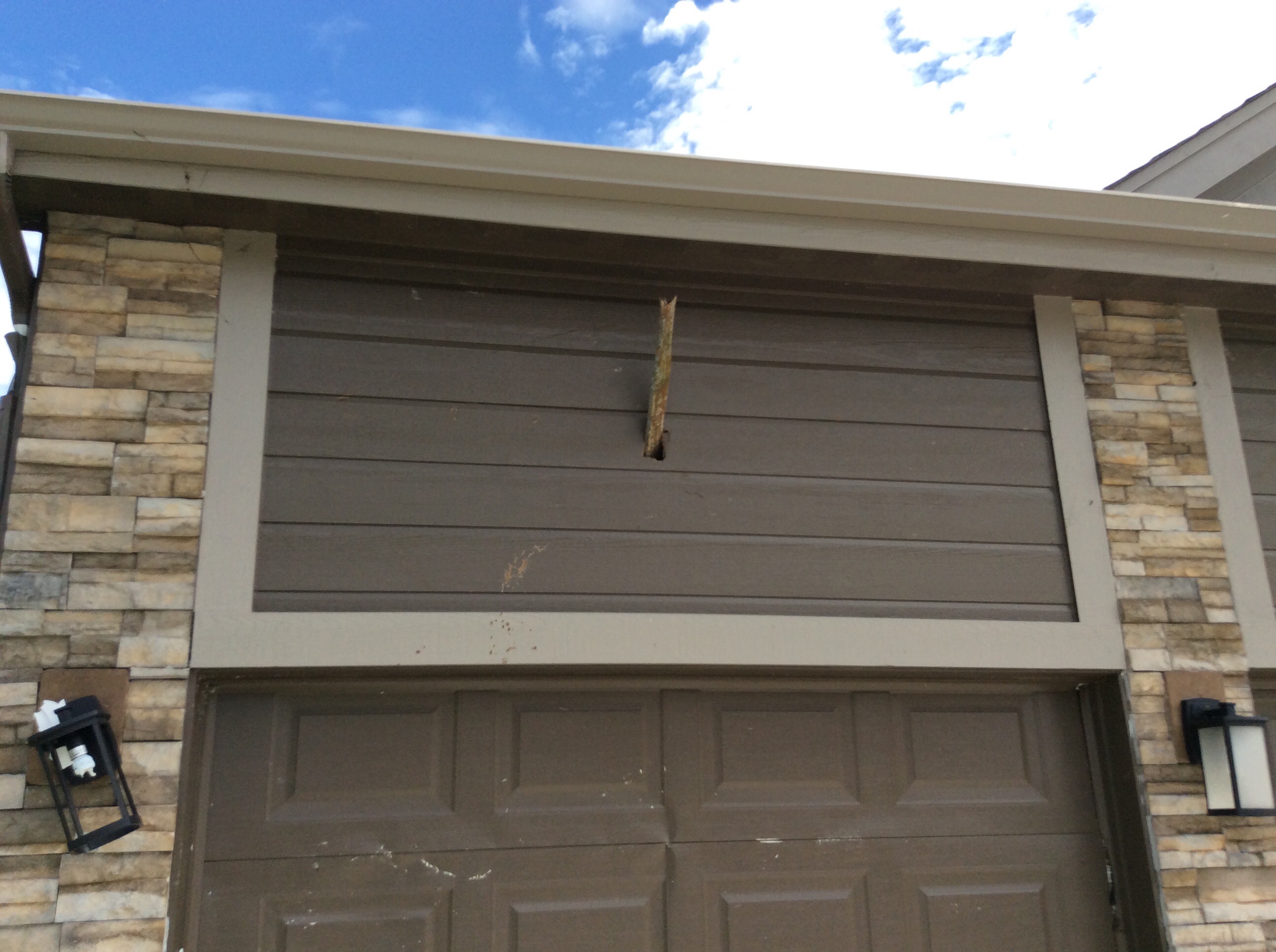
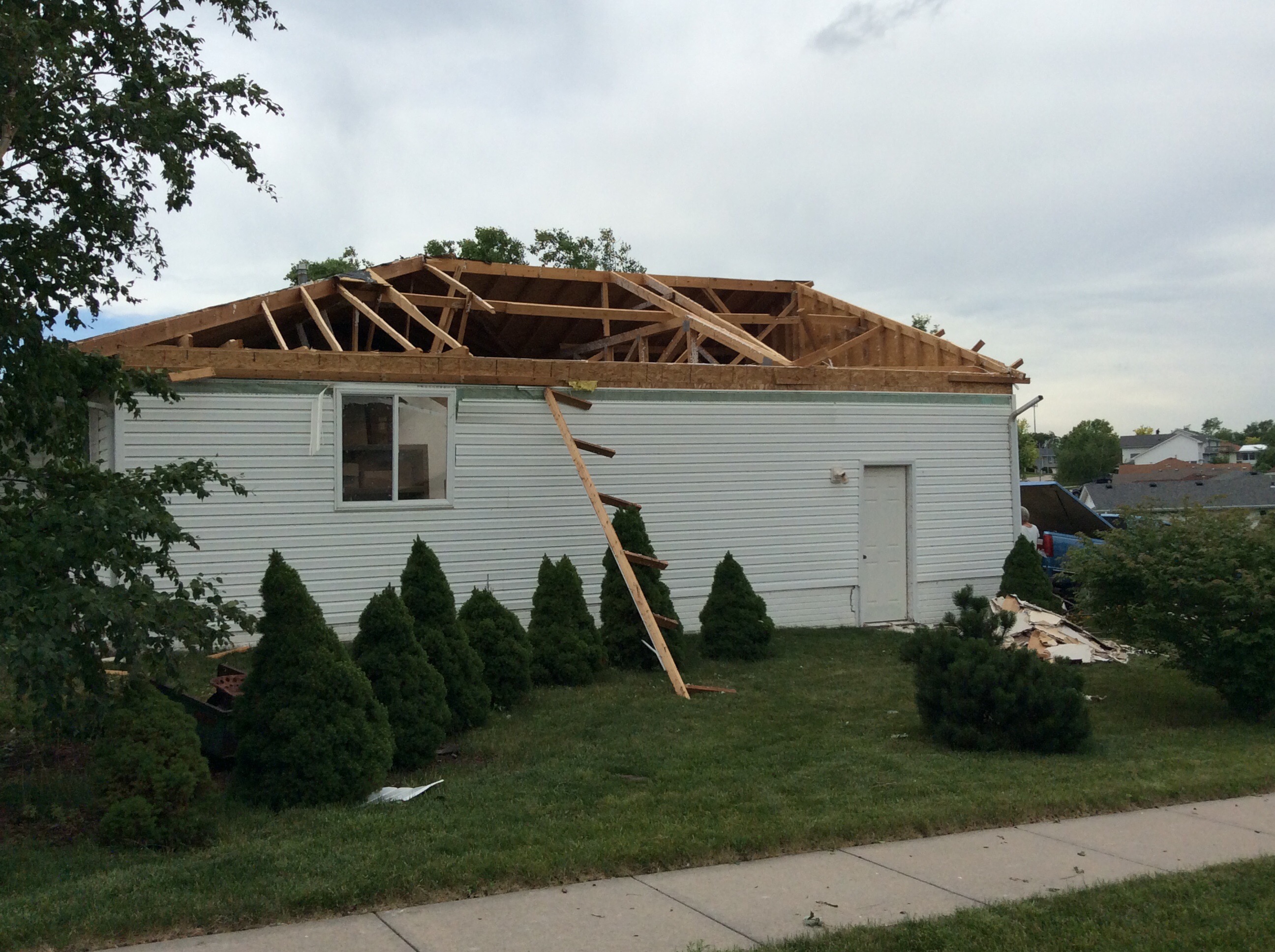
Photos
Sarpy and Mills County Damage Photos:
 |
 |
 |
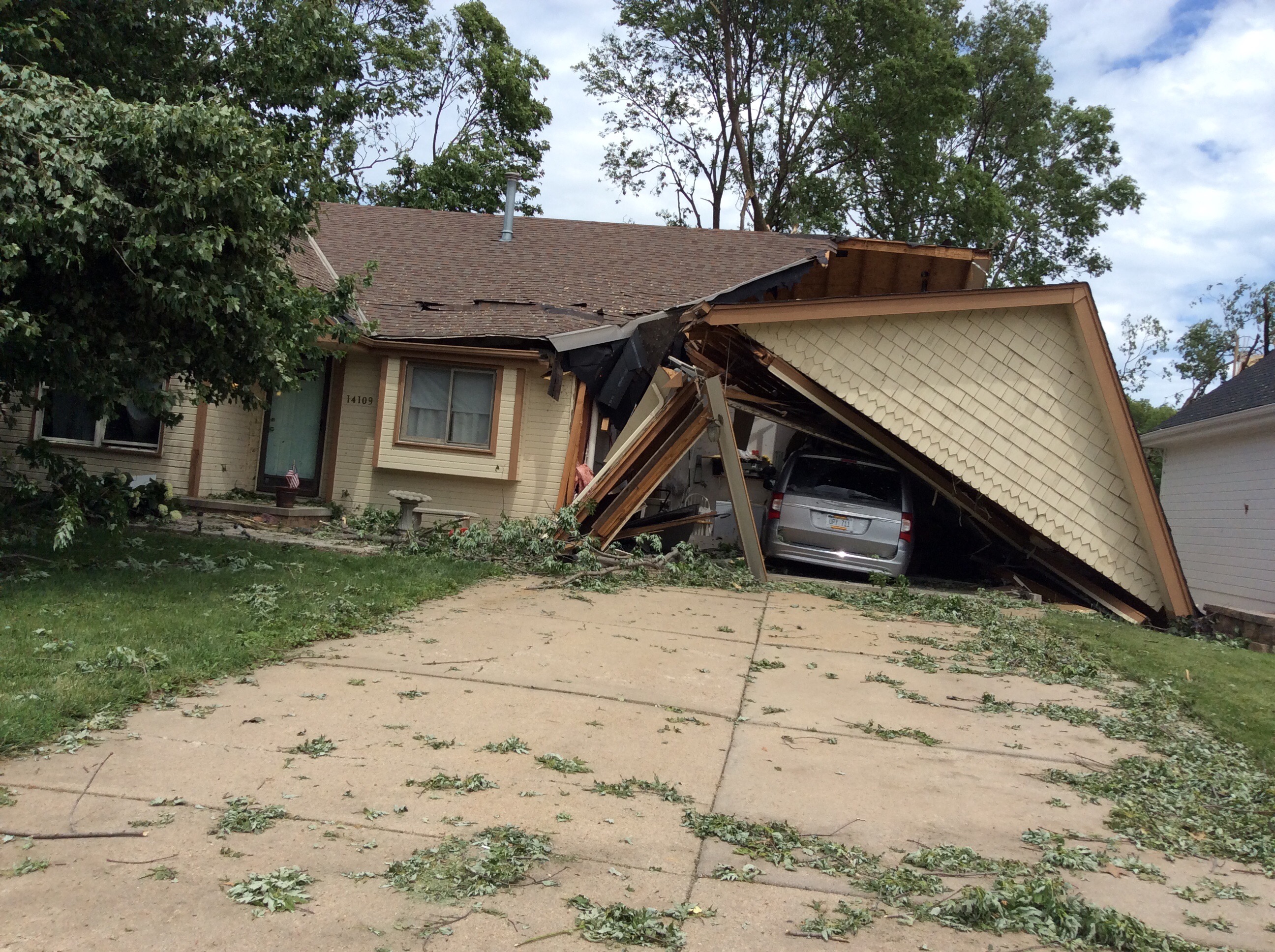 |
| (source: NWS Omaha) | (source: NWS Omaha) | (source: NWS Omaha) | (source: NWS Omaha) |
 |
 |
 |
 |
| (source: NWS Omaha) | (source: NWS Omaha) | (source: NWS Omaha) | (source: NWS Omaha) |
 |
 |
 |
 |
| (source: NWS Omaha) | (source: NWS Omaha) | (source: NWS Omaha) | (source: NWS Omaha) |
Wayne County (near Hoskins) Damage Photos:
 |
 |
 |
| (source: NWS Omaha) | (source: NWS Omaha) | (source: NWS Omaha) |
Gage County Damage Photos:
 |
 |
 |
| (source: NWS Omaha) | (source: NWS Omaha) | (source: NWS Omaha) |
 |
 |
|
| (source: NWS Omaha) |
Bin damage in Holmesville (source: NWS Omaha) |
Hooper Damage Photos:
 |
 |
| (source: NWS Omaha) | (source: NWS Omaha) |
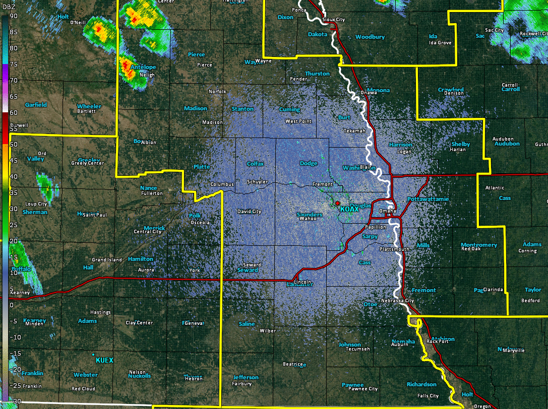
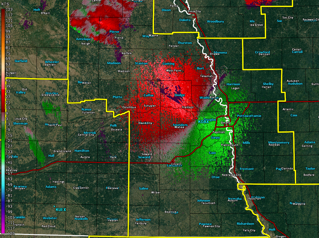
Radar Data
 |
 |
 |
 |
| Reflectivity Loop | Storm-Relative Velocity Loop | Base Velocity Loop | Reflectivity Mosaic |
GOES-16 Visible Satellite
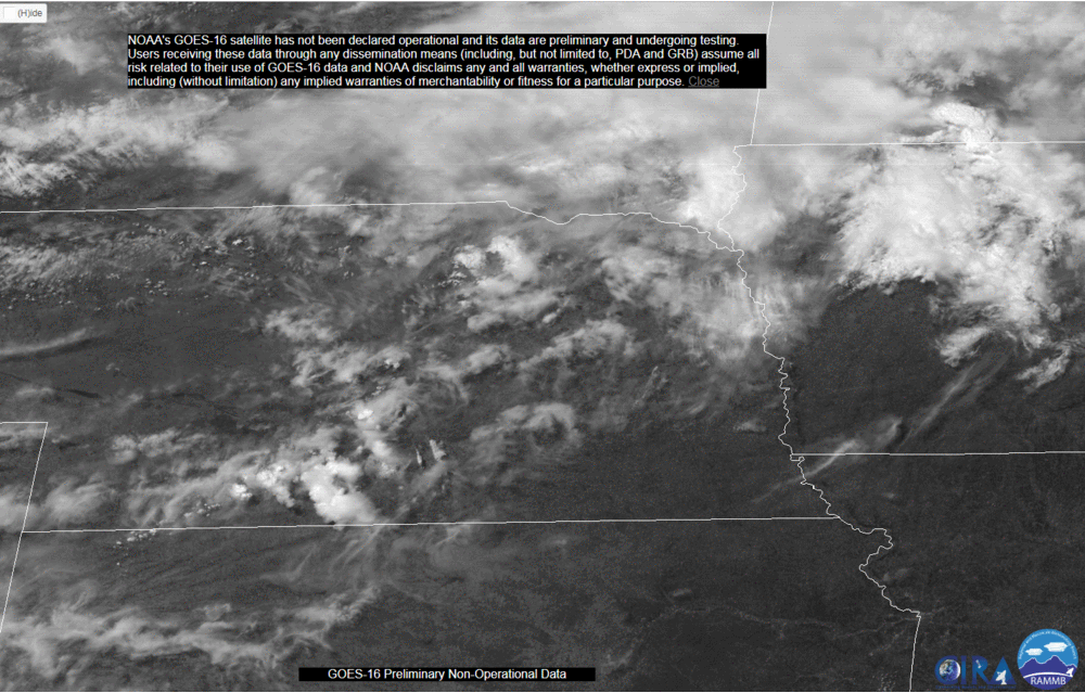 |
| GOES-16 visible satellite loop from 3 PM to just before 9 PM. These data are considered preliminary and non-operational. |
Storm Reports
PRELIMINARY LOCAL STORM REPORT...SUMMARY
NATIONAL WEATHER SERVICE OMAHA/VALLEY NEBRASKA
121 AM CDT SAT JUN 17 2017
..TIME... ...EVENT... ...CITY LOCATION... ...LAT.LON...
..DATE... ....MAG.... ..COUNTY LOCATION..ST.. ...SOURCE....
..REMARKS..
0423 PM HAIL BRUNSWICK 42.34N 97.97W
06/16/2017 M1.00 INCH ANTELOPE NE CO-OP OBSERVER
0447 PM TORNADO 8 N MEADOW GROVE 42.14N 97.75W
06/16/2017 PIERCE NE TRAINED SPOTTER
0458 PM HAIL 6 ENE NELIGH 42.18N 97.93W
06/16/2017 M1.25 INCH ANTELOPE NE STORM CHASER
0515 PM TSTM WND DMG 4 NE HOSKINS 42.15N 97.25W
06/16/2017 WAYNE NE PUBLIC
GRAIN BIN DESTROYED.
0518 PM HAIL 6 W NORFOLK 42.03N 97.54W
06/16/2017 M1.75 INCH MADISON NE TRAINED SPOTTER
0523 PM HAIL 1 N BATTLE CREEK 42.01N 97.60W
06/16/2017 M1.75 INCH MADISON NE TRAINED SPOTTER
0532 PM TORNADO 3 ESE HOSKINS 42.10N 97.25W
06/16/2017 WAYNE NE EMERGENCY MNGR
NEAR THE WAYNE/STANTON COUNTY LINE, FARM HIT AROUND 532
PM AND ENDED BY 537 PM. A SECOND TORNADO WAS SEEN TO THE
SOUTH IN PASTURE LAND BUT DID NOT SEEM TO HIT ANYTHING.
0537 PM TSTM WND GST 4 S NORFOLK 41.98N 97.43W
06/16/2017 M71.00 MPH MADISON NE ASOS
0538 PM TSTM WND GST 4 S NORFOLK 41.98N 97.43W
06/16/2017 M74.00 MPH MADISON NE ASOS
0549 PM HAIL 5 S NORFOLK 41.96N 97.42W
06/16/2017 M1.00 INCH MADISON NE STORM CHASER
0553 PM TORNADO 6 E MADISON 41.82N 97.35W
06/16/2017 STANTON NE STORM CHASER
0556 PM TORNADO 6 E MADISON 41.83N 97.34W
06/16/2017 STANTON NE STORM CHASER
INTERMITTENT VORTICES.
0615 PM HAIL NEWMAN GROVE 41.75N 97.78W
06/16/2017 E1.50 INCH MADISON NE PUBLIC
0618 PM HAIL 5 S LINDSAY 41.63N 97.69W
06/16/2017 M1.00 INCH PLATTE NE STORM CHASER
0623 PM TSTM WND DMG 1 N CRESTON 41.72N 97.36W
06/16/2017 PLATTE NE STORM CHASER
ROOF BLOWN OFF BUILDING. WINDS ESTIMATED AT 60 MPH.
0630 PM HAIL LINDSAY 41.70N 97.69W
06/16/2017 M1.00 INCH PLATTE NE NWS EMPLOYEE
0645 PM HAIL 8 NE MONROE 41.56N 97.49W
06/16/2017 E1.25 INCH PLATTE NE STORM CHASER
0649 PM HAIL 5 NNE GENOA 41.51N 97.70W
06/16/2017 M2.00 INCH PLATTE NE STORM CHASER
0650 PM HAIL 5 NNE GENOA 41.51N 97.70W
06/16/2017 M2.50 INCH PLATTE NE STORM CHASER
0654 PM HAIL MONROE 41.47N 97.60W
06/16/2017 M1.75 INCH PLATTE NE EMERGENCY MNGR
0700 PM HAIL COLUMBUS 41.43N 97.36W
06/16/2017 E1.00 INCH PLATTE NE PUBLIC
0710 PM TSTM WND GST HOOPER 41.61N 96.55W
06/16/2017 E80.00 MPH DODGE NE TRAINED SPOTTER
NUMEROUS STREET SIGNS BLOWN DOWN.
0712 PM TSTM WND GST HOOPER 41.61N 96.55W
06/16/2017 E75.00 MPH DODGE NE TRAINED SPOTTER
0714 PM TSTM WND DMG FREMONT 41.44N 96.49W
06/16/2017 DODGE NE TRAINED SPOTTER
TREE BRANCHES BLOWN DOWN.
0714 PM TSTM WND GST 3 ENE HOOPER 41.63N 96.50W
06/16/2017 E80.00 MPH DODGE NE STORM CHASER
0715 PM TSTM WND DMG 5 N FREMONT 41.51N 96.49W
06/16/2017 DODGE NE TRAINED SPOTTER
TREES AND POWER LINES BLOWN DOWN.
0717 PM TSTM WND GST FREMONT 41.44N 96.49W
06/16/2017 E60.00 MPH DODGE NE TRAINED SPOTTER
0723 PM TSTM WND DMG FREMONT 41.44N 96.49W
06/16/2017 DODGE NE TRAINED SPOTTER
SEVERAL TREES AND POWERLINES DOWN
0725 PM TSTM WND GST 2 NW FREMONT 41.46N 96.52W
06/16/2017 M110 MPH DODGE NE STORM CHASER
0732 PM TSTM WND GST 1 NW VALLEY 41.32N 96.36W
06/16/2017 M63.00 MPH DOUGLAS NE OFFICIAL NWS OBS
AT THE NWS OFFICE.
0735 PM TSTM WND DMG YUTAN 41.24N 96.40W
06/16/2017 SAUNDERS NE NWS EMPLOYEE
FENCE BLOWN DOWN.
0735 PM TSTM WND GST OMAHA 41.26N 96.01W
06/16/2017 M104 MPH DOUGLAS NE TRAINED SPOTTER
173RD AND F. NUMEROUS TREES DOWN AND TRANSFORMERS
0736 PM TSTM WND GST 1 NW VALLEY 41.32N 96.36W
06/16/2017 M88.00 MPH DOUGLAS NE OFFICIAL NWS OBS
AT THE NWS OFFICE.
0740 PM TSTM WND GST ELKHORN 41.28N 96.24W
06/16/2017 E70.00 MPH DOUGLAS NE NWS EMPLOYEE
0740 PM TSTM WND GST LITTLE SIOUX 41.81N 96.03W
06/16/2017 E60.00 MPH HARRISON IA CO-OP OBSERVER
0748 PM TSTM WND GST 3 NNE GRETNA 41.17N 96.21W
06/16/2017 E85.00 MPH SARPY NE PUBLIC
0750 PM TSTM WND DMG 2 W MILLARD 41.21N 96.19W
06/16/2017 DOUGLAS NE PUBLIC
TREES DOWN.
0750 PM TSTM WND GST DAVID CITY 41.25N 97.13W
06/16/2017 E50.00 MPH BUTLER NE EMERGENCY MNGR
0753 PM TSTM WND DMG ASHLAND 41.04N 96.37W
06/16/2017 SAUNDERS NE STORM CHASER
NUMEROUS TREES DOWN AND DAMAGE TO COUNTRY CLUB
0755 PM TSTM WND GST GRETNA 41.14N 96.24W
06/16/2017 E70.00 MPH SARPY NE NWS EMPLOYEE
0755 PM TSTM WND GST GRETNA 41.14N 96.24W
06/16/2017 E70.00 MPH SARPY NE TRAINED SPOTTER
0755 PM TSTM WND DMG OMAHA 41.26N 96.01W
06/16/2017 DOUGLAS NE TRAINED SPOTTER
132ND AND HARRISON AREA. BIG TREES DOWN ALONG WITH
SEVERAL FENCES IN THE NEIGHBOOD.
0755 PM TSTM WND DMG WOODBINE 41.74N 95.71W
06/16/2017 HARRISON IA EMERGENCY MNGR
ROOF BLOWN OFF INDUSTRIAL BUILDING. WIDESPREAD TREE
DAMAGE, IN TOWN, AND WEST OF TOWN.
0758 PM TSTM WND GST 1 S GRETNA 41.13N 96.24W
06/16/2017 E80.00 MPH SARPY NE TRAINED SPOTTER
0759 PM TSTM WND GST OMAHA 41.26N 96.01W
06/16/2017 M72.00 MPH DOUGLAS NE TRAINED SPOTTER
132ND AND CORNHUSKER
0759 PM TSTM WND GST 4 SSW GRETNA 41.09N 96.27W
06/16/2017 M74.00 MPH SARPY NE TRAINED SPOTTER
0800 PM TSTM WND DMG COUNCIL BLUFFS 41.24N 95.86W
06/16/2017 POTTAWATTAMIE IA PUBLIC
ROOF DAMAGED FROM 5 INCH LIMB BLOWN ONTO HOME.
0800 PM TSTM WND DMG PAPILLION 41.16N 96.04W
06/16/2017 SARPY NE TRAINED SPOTTER
WIDEPSREAD TREE AND FENCE DAMAGE.
0804 PM TSTM WND GST 5 NNW COUNCIL BLUFFS 41.30N 95.90W
06/16/2017 M60.00 MPH DOUGLAS NE ASOS
AT OMAHA AIRPORT.
0806 PM TSTM WND GST PAPILLION 41.16N 96.04W
06/16/2017 E70.00 MPH SARPY NE TRAINED SPOTTER
0810 PM TSTM WND DMG S OFFUTT AFB 41.11N 95.92W
06/16/2017 SARPY NE AMATEUR RADIO
TREES TOPPED AND CONSIDERABLE ROOF DAMAGE.
0810 PM TSTM WND DMG 1 SW OFFUTT AFB 41.10N 95.93W
06/16/2017 SARPY NE BROADCAST MEDIA
SIGNIFICANT DAMAGE TO MULTIPLE HOMES IN THE HYDA HILLS
NEIGHBORHOOD.
0810 PM TSTM WND GST BELLEVUE 41.16N 95.92W
06/16/2017 E80.00 MPH SARPY NE PUBLIC
0815 PM TSTM WND DMG BRANCHED OAK STATE RECR 40.97N 96.87W
06/16/2017 LANCASTER NE AMATEUR RADIO
MAJOR TREE DAMAGE.
0815 PM TSTM WND DMG PLATTSMOUTH 41.01N 95.89W
06/16/2017 CASS NE EMERGENCY MNGR
*** 4 INJ *** SUBSTANTIAL DAMAGE IN THE TOWN. TREES DOWN
ON MOST ROADS. POWERLINES BLOWN DOWN. NO POWER BETWEEN
LOUISVILLE AND PLATTSMOUTH AND WEEPING WATER. COUNTY
MAINTENANCE BUILDING DESTROYED. SEVERAL FARMSTEADS ALONG
HIGHWAY 66 DESTROYED. 3 INJURIES IN PLATTSMOUTH, 1 INJURY
AT LOUISVILLE STATE PARK. TIME ESTIMATED.
0815 PM TSTM WND DMG 3 W PACIFIC JUNCTION 41.02N 95.86W
06/16/2017 MILLS IA TRAINED SPOTTER
LARGE TREES BLOWN DOWN. WINDOWS ON HOUSE BROKEN.
0821 PM HAIL FRIEND 40.65N 97.28W
06/16/2017 M0.88 INCH SALINE NE EMERGENCY MNGR
0825 PM HAIL GARLAND 40.94N 96.99W
06/16/2017 M1.00 INCH SEWARD NE EMERGENCY MNGR
0835 PM TSTM WND DMG 2 S THURMAN 40.79N 95.75W
06/16/2017 FREMONT IA TRAINED SPOTTER
VERY LARGE TREES BLOCKING THE ROAD
0835 PM HAIL PLEASANT DALE 40.79N 96.93W
06/16/2017 M2.00 INCH SEWARD NE TRAINED SPOTTER
0835 PM TSTM WND GST MALCOLM 40.91N 96.87W
06/16/2017 E70.00 MPH LANCASTER NE AMATEUR RADIO
0835 PM TSTM WND GST 5 S HARLAN 41.58N 95.34W
06/16/2017 M62.00 MPH SHELBY IA AWOS
0837 PM TSTM WND GST 4 NW LINCOLN 40.86N 96.75W
06/16/2017 M87.00 MPH LANCASTER NE ASOS
AT THE LINCOLN AIRPORT.
0838 PM TSTM WND DMG 3 W OAKLAND 41.31N 95.45W
06/16/2017 POTTAWATTAMIE IA PUBLIC
TREES DOWN ONTO ROAD. TIME ESTIMATED
0840 PM HAIL LINCOLN 40.82N 96.69W
06/16/2017 E2.50 INCH LANCASTER NE EMERGENCY MNGR
ALSO 60 MPH WIND.
0840 PM TSTM WND DMG LINCOLN 40.82N 96.69W
06/16/2017 LANCASTER NE AMATEUR RADIO
SEVERAL SEMIS TIPPED OVER JUST EAST OF 27TH STREET ON
I-80. WATER OVER ROADS JUST SOUTH OF THERE AS WELL.
0848 PM HAIL LINCOLN 40.82N 96.69W
06/16/2017 M1.00 INCH LANCASTER NE PUBLIC
AT 48TH AND HIGHWAY 2. 60 MPH WINDS ALSO.
0849 PM TSTM WND DMG LINCOLN 40.82N 96.69W
06/16/2017 LANCASTER NE EMERGENCY MNGR
NUMEORUS REPORTS OF TREES AND POWER LINES DOWN.
0849 PM TSTM WND DMG 3 E THURMAN 40.82N 95.69W
06/16/2017 FREMONT IA TRAINED SPOTTER
SEVERAL TREES DOWN. ESTIMATED 60 MPH
0850 PM TSTM WND DMG LINCOLN 40.82N 96.69W
06/16/2017 LANCASTER NE AMATEUR RADIO
SEVERAL SEMIS FLIPPED IN LINCOLN.
0857 PM TSTM WND GST 4 S DORCHESTER 40.59N 97.11W
06/16/2017 M63.00 MPH SALINE NE STORM CHASER
0904 PM TSTM WND GST 5 S DORCHESTER 40.58N 97.11W
06/16/2017 E60.00 MPH SALINE NE STORM CHASER
0905 PM TSTM WND DMG WILBER 40.48N 96.96W
06/16/2017 SALINE NE EMERGENCY MNGR
TWO HOMES DAMAGED FROM WIND ON WEST SIDE OF TOWN. ALSO A
COUPLE OF HOMES HAD LIGHTNING DAMAGE.
0905 PM TSTM WND DMG CLATONIA 40.46N 96.85W
06/16/2017 GAGE NE EMERGENCY MNGR
MOBILE HOME LOST ROOF, NORTH SIDE OF TOWN. TIME
ESTIMATED.
0905 PM TSTM WND DMG GRANT 41.14N 94.99W
06/16/2017 MONTGOMERY IA EMERGENCY MNGR
TREES AND POWER LINES DOWN. TIME ESTIMATED
0906 PM HAIL CRETE 40.63N 96.96W
06/16/2017 M1.25 INCH SALINE NE PUBLIC
0913 PM TSTM WND GST WILBER 40.48N 96.96W
06/16/2017 M65.00 MPH SALINE NE STORM CHASER
0915 PM TSTM WND DMG 2 E STERLING 40.46N 96.34W
06/16/2017 JOHNSON NE TRAINED SPOTTER
VERY LARGE TREES UPROOTED. POWER LINES BLOWN DOWN.
0920 PM HAIL 8 S FRIEND 40.54N 97.28W
06/16/2017 M0.88 INCH SALINE NE TRAINED SPOTTER
UP TO NICKEL SIZE HAIL
0921 PM HAIL 8 S FRIEND 40.54N 97.28W
06/16/2017 E0.88 INCH SALINE NE TRAINED SPOTTER
0934 PM TSTM WND GST 5 W BEATRICE 40.27N 96.84W
06/16/2017 M80.00 MPH GAGE NE TRAINED SPOTTER
HALF INCH HAIL. SUBSTANTIAL TREE AND POWER LINE DAMAGE.
PIVOTS FLIPPED.
0935 PM TSTM WND DMG 5 NW BEATRICE 40.32N 96.81W
06/16/2017 GAGE NE STORM CHASER
TREES BLOWN DOWN ONTO THE ROAD.
0935 PM TSTM WND DMG BEATRICE 40.27N 96.75W
06/16/2017 GAGE NE EMERGENCY MNGR
TREE AND POWER LINE DAMAGE IN TOWN. TIME ESTIMATED
0939 PM TSTM WND GST 6 NW BEATRICE 40.33N 96.83W
06/16/2017 E100 MPH GAGE NE STORM CHASER
0940 PM TSTM WND DMG 6 E PLYMOUTH 40.30N 96.87W
06/16/2017 GAGE NE STORM CHASER
POWER POLES AND TREES SNAPPED.
0942 PM TSTM WND GST 6 E PLYMOUTH 40.30N 96.87W
06/16/2017 E80.00 MPH GAGE NE STORM CHASER
0942 PM HEAVY RAIN SIDNEY 40.75N 95.64W
06/16/2017 M3.00 INCH FREMONT IA TRAINED SPOTTER
0947 PM TSTM WND GST 3 N BEATRICE 40.31N 96.75W
06/16/2017 M85.00 MPH GAGE NE ASOS
0948 PM TSTM WND DMG PERU 40.48N 95.73W
06/16/2017 NEMAHA NE EMERGENCY MNGR
MEDIUM LIMBS BLOWN DOWN.
1011 PM HAIL 3 E ALEXANDRIA 40.25N 97.33W
06/16/2017 E1.75 INCH JEFFERSON NE TRAINED SPOTTER
1019 PM HAIL 6 NW FAIRBURY 40.20N 97.26W
06/16/2017 E1.75 INCH JEFFERSON NE EMERGENCY MNGR
1021 PM HAIL 6 W FAIRBURY 40.14N 97.29W
06/16/2017 M1.00 INCH JEFFERSON NE TRAINED SPOTTER
1026 PM HAIL 4 W FAIRBURY 40.14N 97.25W
06/16/2017 E1.75 INCH JEFFERSON NE EMERGENCY MNGR
1027 PM TSTM WND GST 2 SW FAIRBURY 40.12N 97.20W
06/16/2017 M58.00 MPH JEFFERSON NE EMERGENCY MNGR
CRYSTAL SPRINGS WEATHER STATION.
1045 PM HAIL REYNOLDS 40.06N 97.34W
06/16/2017 E2.75 INCH JEFFERSON NE TRAINED SPOTTER
GOLF BALL TO BASEBALL SIZE HAIL.
&&
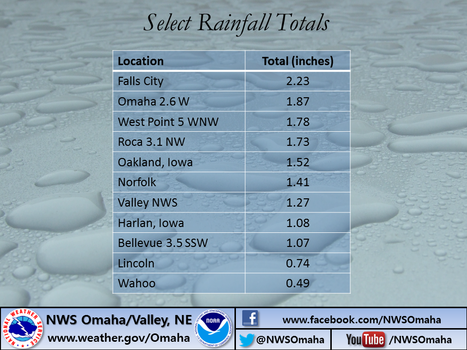
Rain Reports

Environment
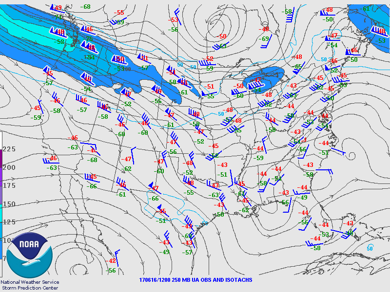
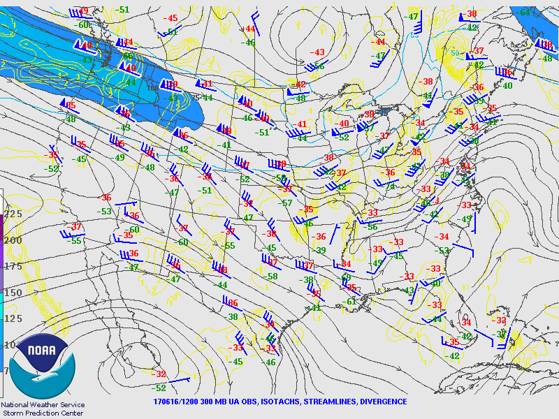
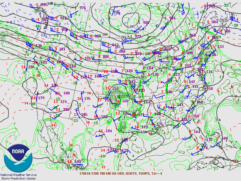
Synoptic Overview at 12z (courtesy of SPC)
 |
 |
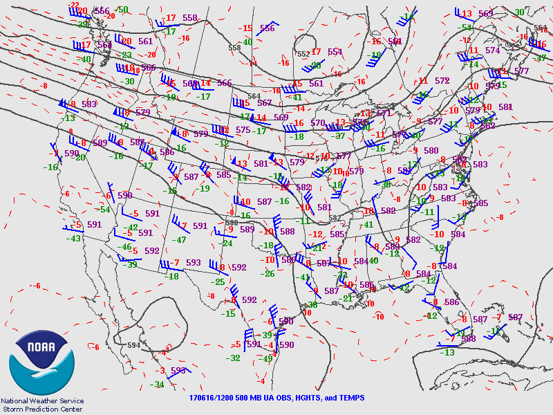 |
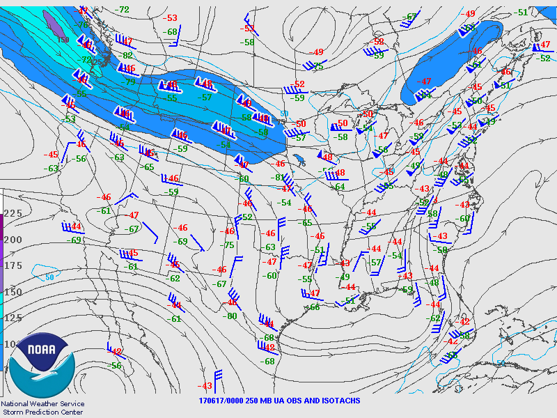
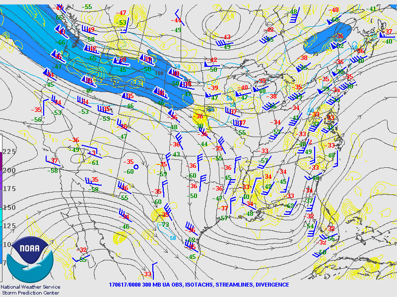
| Figure 1: 250-mb analysis | Figure 2: 300-mb analysis | Figure 3: 500-mb analysis |
 |
 |
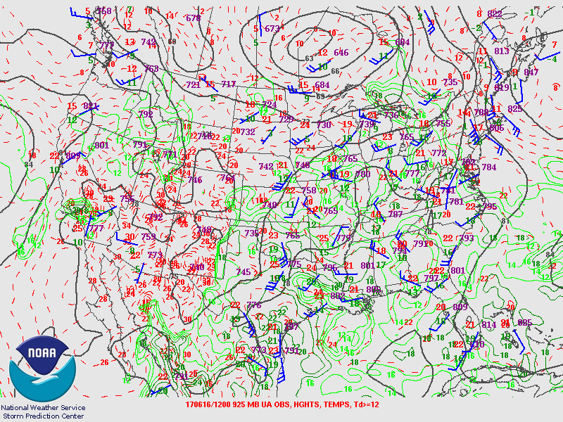 |
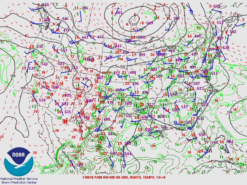
| Figure 4: 700-mb analysis | Figure 5: 850-mb analysis | Figure 6: 925-mb analysis |
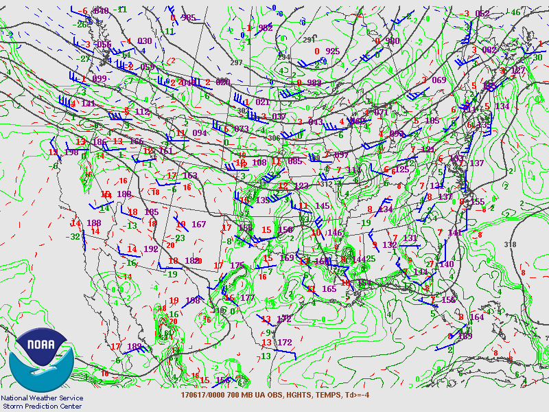
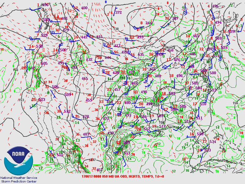
Synoptic Overview at 00z (courtesy of SPC)
 |
 |
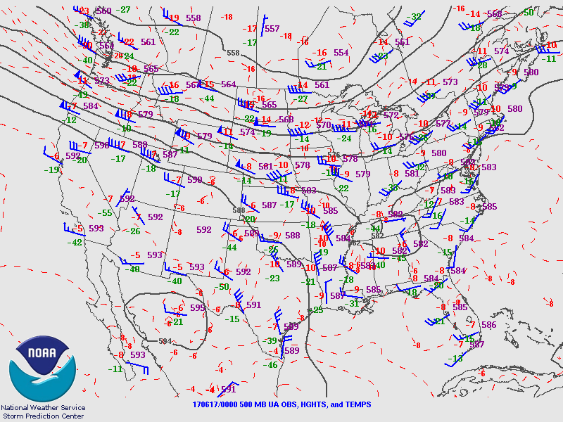 |
| Figure 7: 250-mb analysis | Figure 8: 300-mb analysis | Figure 9: 500-mb analysis |
 |
 |
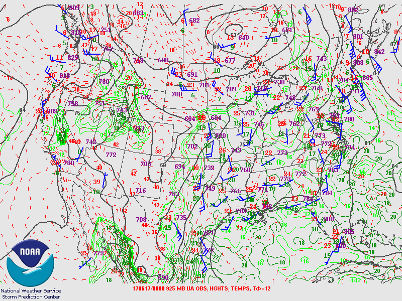 |
| Figure 10: 700-mb analysis | Figure 11: 850-mb analysis | Figure 12: 925-mb analysis |
Surface Map (courtesy of WPC)
 |
 |
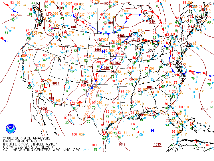 |
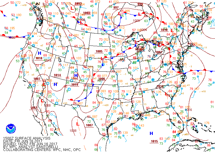
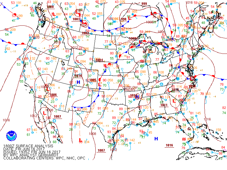
| Figure 13: 15z surface map | Figure 14: 18z surface map | Figure 15: 21z surface map |
 |
 |
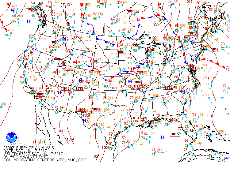 |
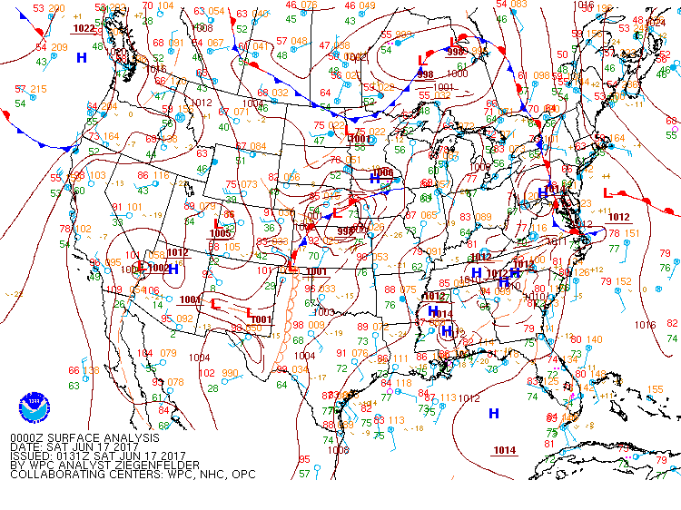
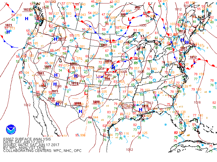
| Figure 16: 00z surface map | Figure 17: 03z surface map | Figure 18: 06z surface map |
 |
 |
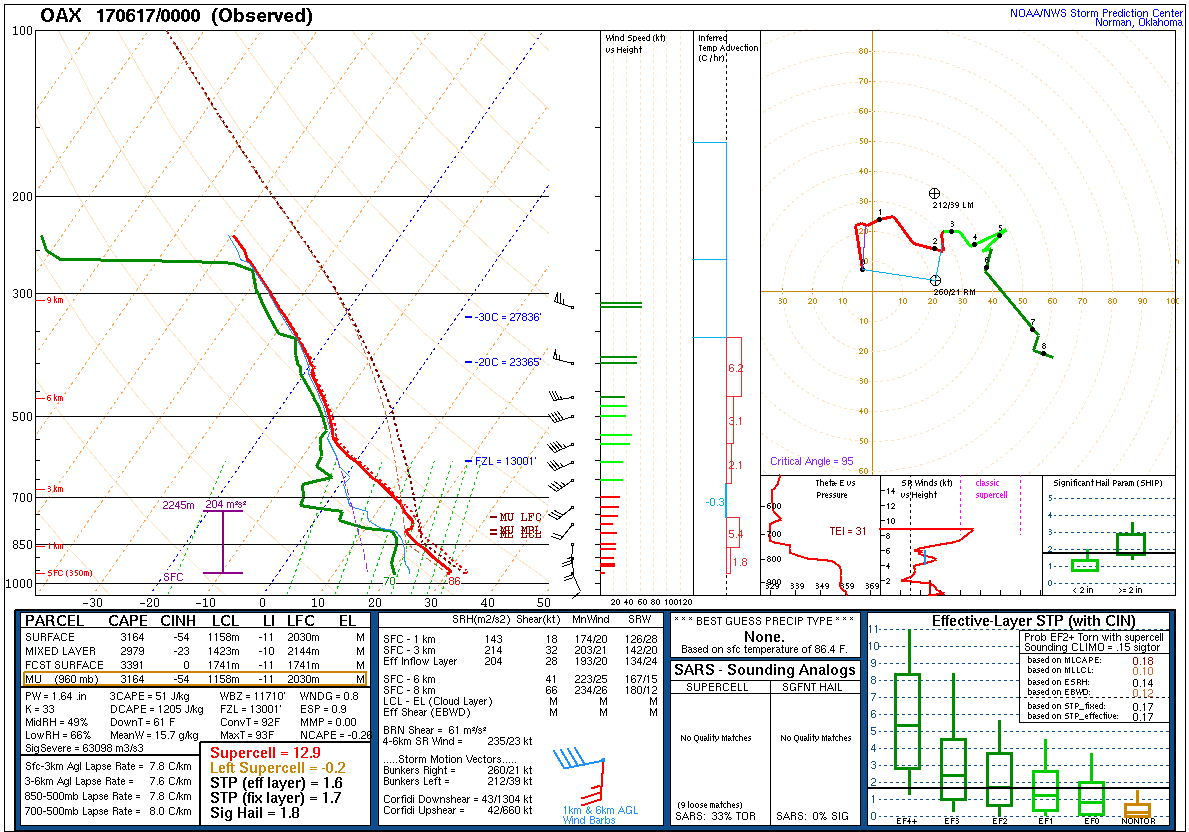 |
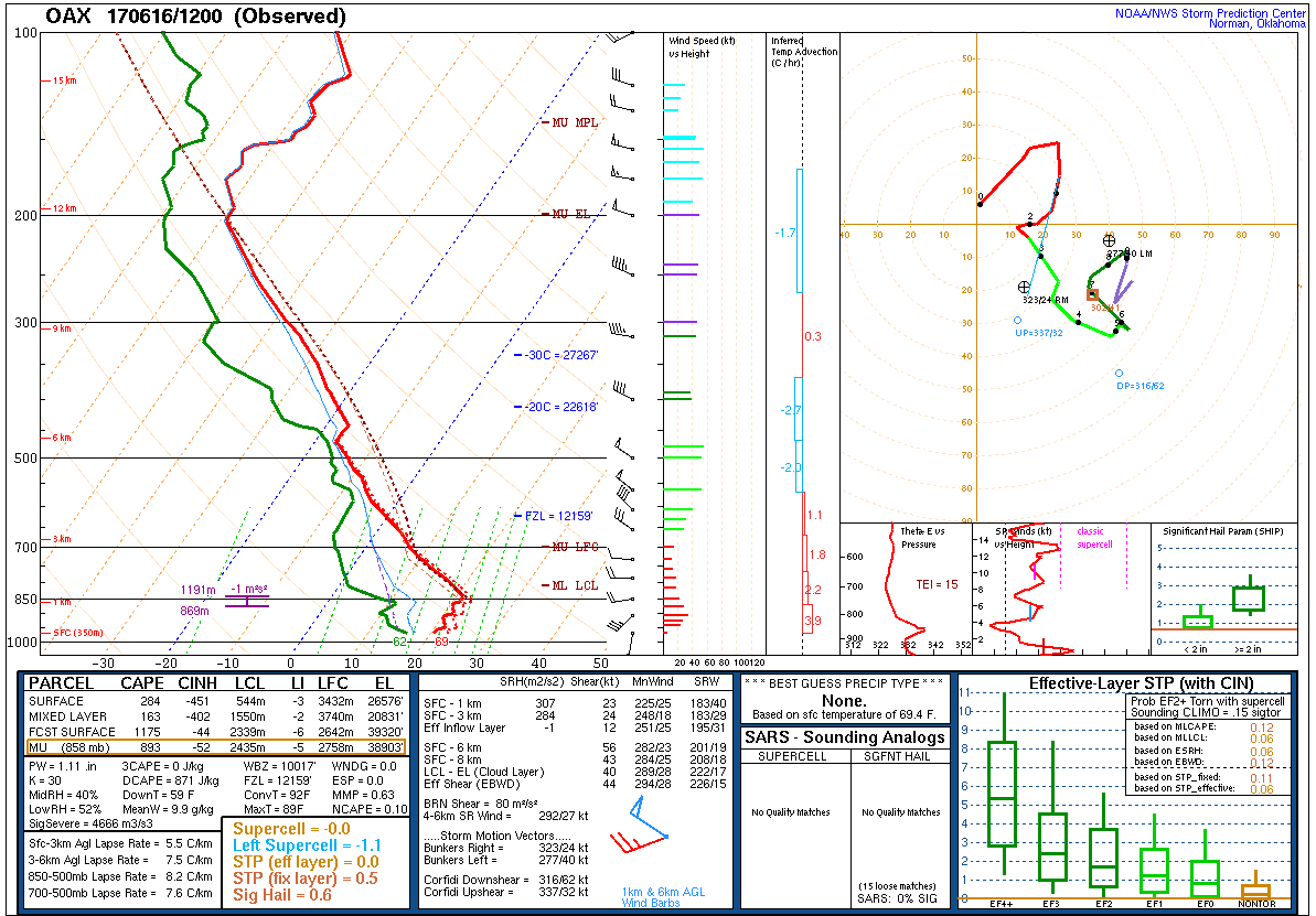
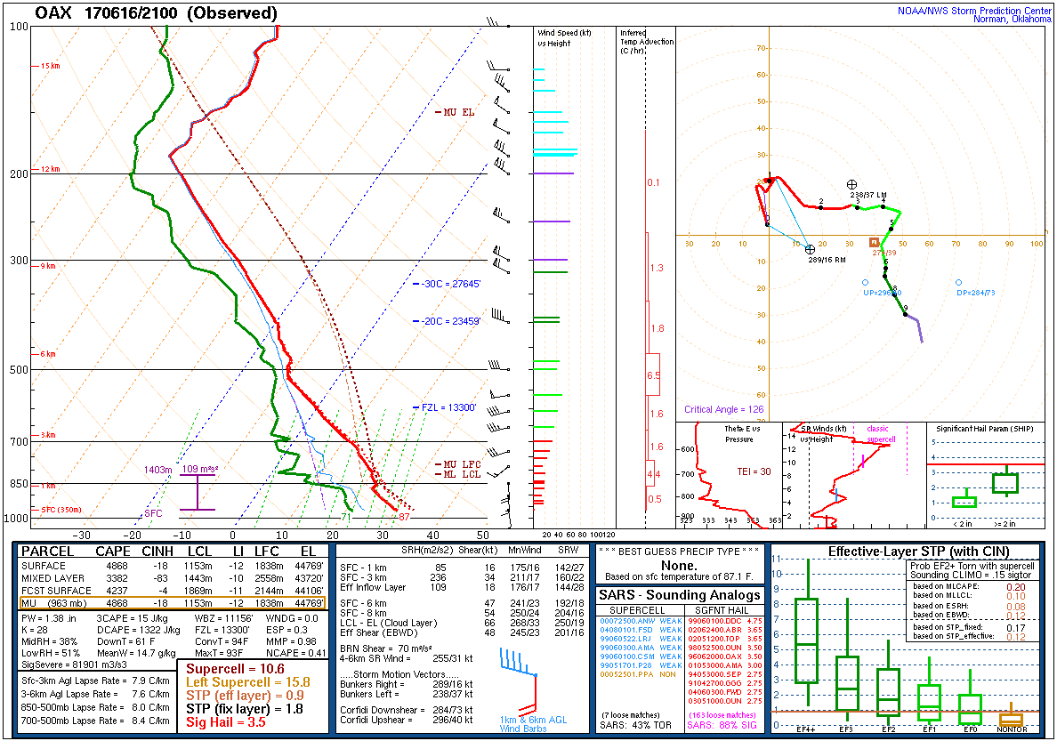
| Figure 19: 12z Omaha, NE sounding | Figure 20: 21z Omaha, NE sounding | Figure 21: 00z Omaha, NE sounding |
 |
 |
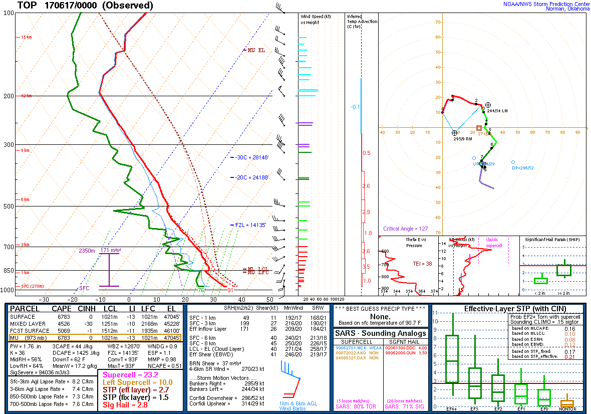 |
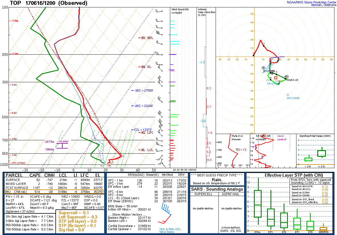
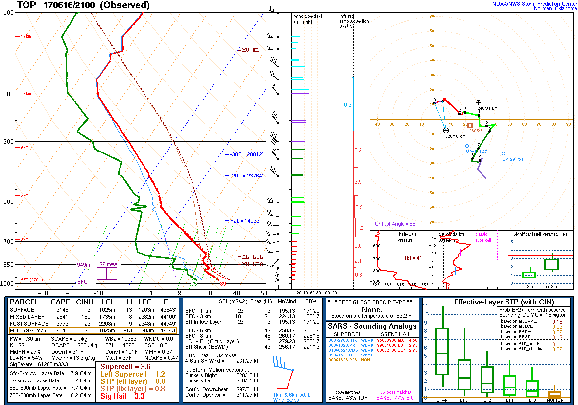
| Figure 22: 12z Topeka, KS sounding | Figure 23: 21z Topeka, KS sounding | Figure 24: 00z Topeka, KS sounding |
 |
 |
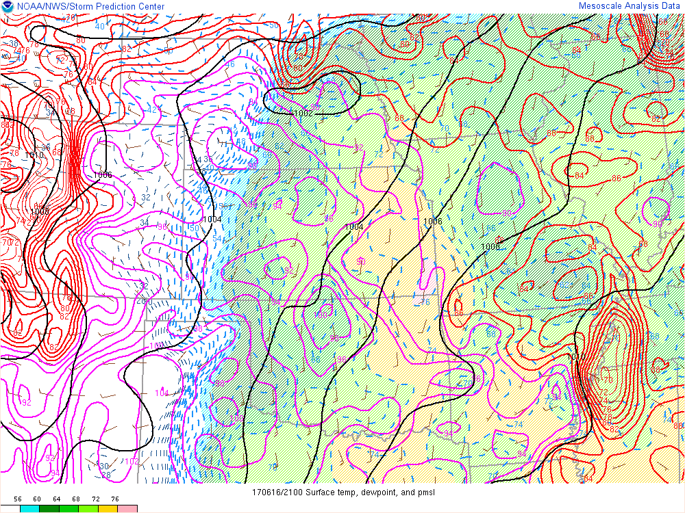 |
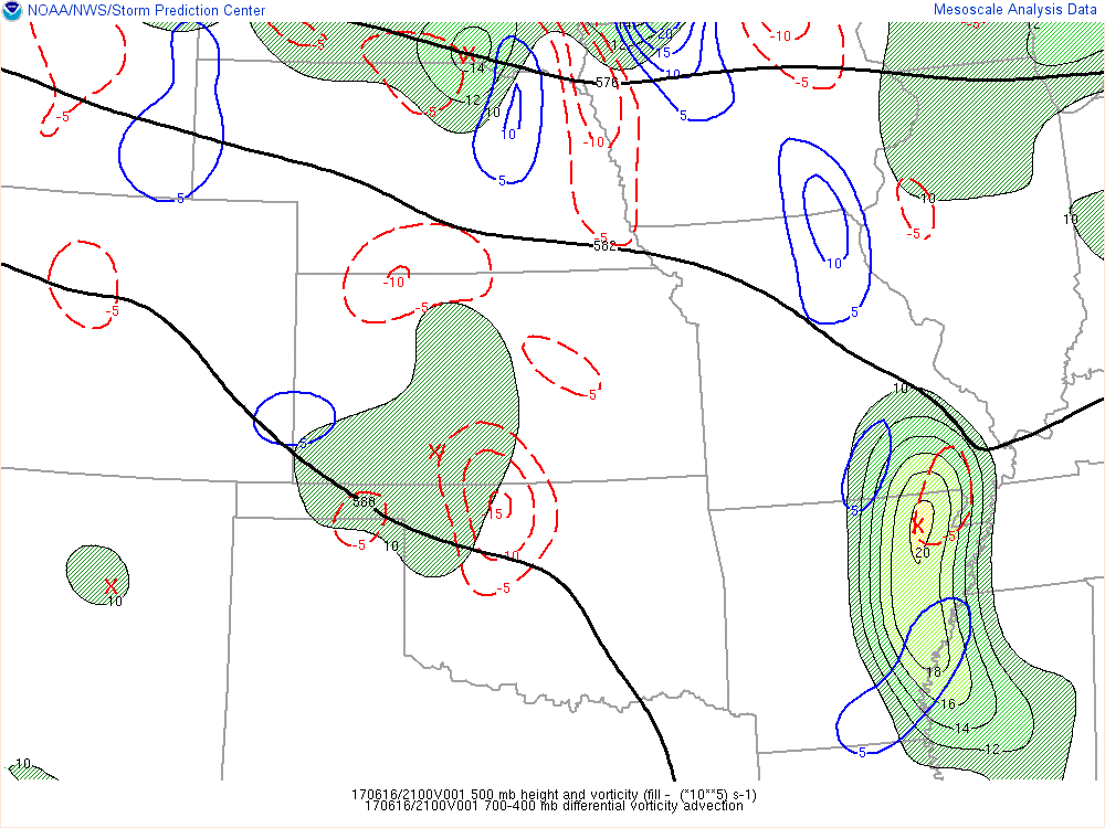
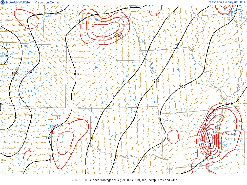
| Figure 25: 500-mb heights, vorticity, and vorticity advection at 21z. Note the weak impulse embedded in the northwest flow across southern SD into northern NE. | Figure 26: Surface pressure, wind, temperature and frontogenesis (red) at 21z. Storms initiated near the surface triple point over north-central NE. | Figure 27: Surface pressure, wind, temperature and dewpoint at 21z. Note the strong heating to the west of the dryline across western into central NE. This heating coupled with convergence along the boundaries and the influence of the mid-level impulse (Fig. 25) likely all contributed to the storm formation. |
 |
 |
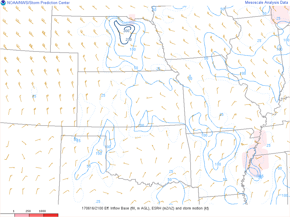 |
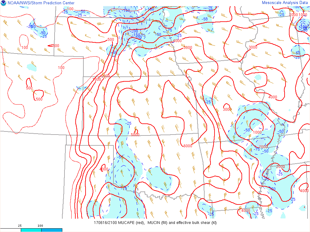
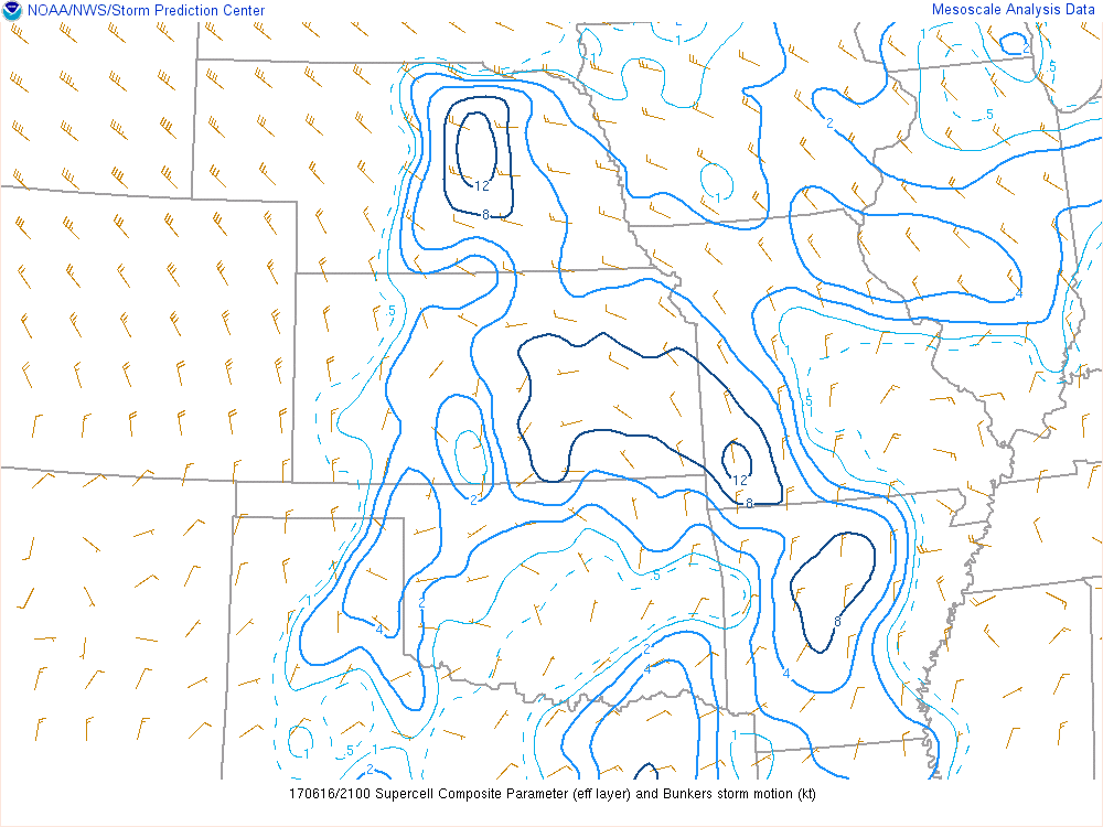
| Figure 28: muCAPE and effective bulk shear at 21z. Note the overlap of strong instability and vertical shear across much of eastern NE and southwest IA. | Figure 29: Supercell Composite Parameter (SCP) at 21z. The most favorable environment for supercells existed near the surface triple point at that time. | Figure 30: Effective storm-relative helicity at 21z. Low-level shear was maximized near the surface front where winds were locally backed. |
 |
Media use of NWS Web News Stories is encouraged! Please acknowledge the NWS as the source of any news information accessed from this site. |
|