
Strong to severe thunderstorms will continue tonight across portions of the Ohio Valley into the Mid-Atlantic. Heavy rains may bring an isolated flash flooding threat over the central Appalachians, particularly in West Virginia. Moderate to heavy snow will continue over portions of northern Minnesota and the Upper Peninsula of Michigan through Tuesday morning. Read More >
| About Skywarn | ||
|
SKYWARN, founded in the early 1970's is made up of a group of trained, dedicated amateur weather enthusiast who work in conjunction with the National Weather Service by observing and reporting adverse weather conditions to promote public safety and minimize property damage. In the advent of Doppler Radar, and other technologies, the art and science of weather forecasting has made great strides, but even with all the technology, the National Weather Service still is in need of 'ground truth' observers. It is through training that the NWS teaches interested volunteers to be safe, effective and accurate weather spotters who provide them with the needed ground truths. SKYWARN, generally speaking, is placed on stand-by when a severe weather watch is posted by the National Weather Service. Once that watch is upgraded to a warning, SKYWARN becomes activated and spotters are asked to make severe weather observations. After making an observation that is reportable, there are several ways to relay the information to the National Weather Forecast Office which include: telephone, amateur radio, and an online storm report form. Some of the reports are used to send out statements, warnings and short-term forecasts to the public via the media. The reports also go into "Storm Data", which is a publication that documents severe weather across the country and can be used to create a severe weather climatology database of a specific county, city or region of the country. |
||
 |
 |
Reporting Severe Weather
Reporting severe weather is essential! Regardless of the reporting method, each report must include the time & location of the event (and direction looking if applicable). Pictures tell a thousand words, but not when and where the weather occurred! If you do send photos, please let us know if you grant permission for us to use them in future spotter talks and outreach presentations.
How to Report:
Email: mso.media@noaa.gov - A great way to include pictures & video.
Online: https://inws.ncep.noaa.gov/report/ -Able to use on a mobile device or home computer.
Telephone: NWS Missoula Severe Weather 800 Number - Must have been through severe weather spotter training and belong to a spotter network to use this line! Refer to materials received during spotter training.
Or call 406-329-4840
Facebook: Visit our Facebook page and post a severe weather report to our wall.
Twitter: Tweet us your reports by including the #idwx or #mtwx hashtag or send them directly to @NWSMissoula.
mPing: Send reports from your location via a smartphone app
Amateur Radio: The National Weather Service group amateur radio call-sign is WX7MSO.
What to Report:
With any report, please include your location (city or distance from city, street intersection, lat./lon.), the time of the event, and who you are (public, spotter #, law enforcement, etc.)
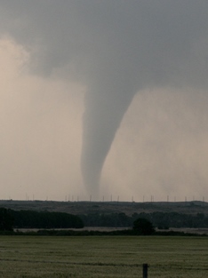
Tornadoes
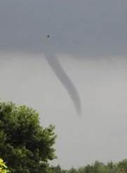
Wall Clouds & Funnel Clouds
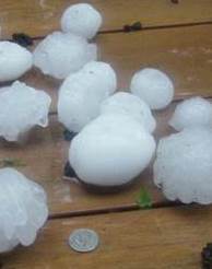
Hail
| Hail Size | Inches |
|---|---|
| Pea | 1/4 |
| Dime | 1/2 |
| Penny | 3/4 |
| Nickel | 7/8 |
| Quarter | 1 |
| Half Dollar | 1 1/4 |
| Ping Pong Ball | 1 1/2 |
| Golf Ball | 1 3/4 |
| Hen Egg | 2 |
| Tennis Ball | 2 1/2 |
| Baseball | 2 3/4 |
| Softball | 4 |
| Grapefruit | 4 1/2 |
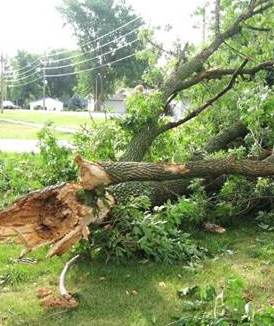
Damaging Winds
| Speed (mph) |
Designation | Description |
|---|---|---|
| <1 | Calm | Smoke rises vertically |
| 1-3 | Light air | Smoke drift indicates wind direction |
| 4-7 | Light breeze | Weather vane moves, leaves rustle |
| 8-12 | Light breeze | Leaves and twigs in constant motion |
| 13-18 | Mod breeze | Dust raised, small branches move |
| 19-24 | Fresh breeze | Small trees sway |
| 25-31 | Strong breeze | Large branches move |
| 32-38 | Moderate gale | Whole trees move, walking affected |
| 39-46 | Fresh gale | Twigs break off trees, walking difficult |
| 47-54 | Strong gale | Minor structural damage |
| 55-63 | Whole gale | Large tree branches break |
| 64-74 | Storm | Widespread damage |
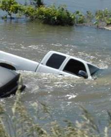
Flash Flooding & Heavy Rain
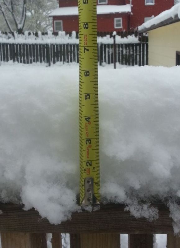
Snow & Ice
Outlooks, Watches & Warnings
Severe Weather Outlooks:
 |
 |
 |
 |
| Day 1 Outlook | Day 2 Outlook | Day 3 Outlook | Days 4-8 Outlooks |
 |
 |
 |
 |
| Idaho Day 1 Outlook | Montana Day 1 Outlook | Idaho Day 2 Outlook | Montana Day 2 Outlook |
Severe Weather Discussion, Watches, and Environmental Data:
 |
 |
 |
 |
| Mesoscale Discussions | Active Watches | Outlook, Watches & Radar | Mesoanalysis Data |
Northern Rockies Weather and Storm Reports:
 |
 |
 |
 |
| Current Radar & Warnings | Weather Story | Today's Storm Reports | Yesterday's Storm Reports |
Spotter Resources
The National Weather Service (NWS) hosts a combination of in-person and webinar-based spotter training classes across the Northern Rockies every year. For more information on these classes, please see the Spotter Training tab above.
In addition to live National Weather Service spotter training presentations, there are several online training opportunities available.
Online Resources
Other Training Resources
Public Reports Series |
Why We Need Spotters
|
Winter Safety Tips |
Lightning Safety
|
Compressed Spotter Training |
2020 Spotter Training
|

