Overview
Two main rounds of rain and thunderstorms moved across southern Wisconsin from September 6th through the 7th. Two day rainfall totals were mainly in the 1 to 3 inch range, though some locations received up to 7 inches of rain! This heavy rain led to some localized flooding in locations such as Mayville, Milwaukee, West Allis and Rock Springs.
Flooding
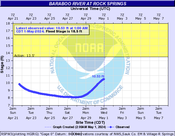
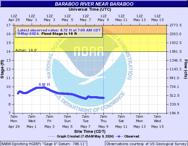
Hydrographs
 |
 |
 |
|
| Baraboo River at Rock Springs | Baraboo River near Baraboo | Baraboo River at Reedsburg |
Radar Rainfall Estimates
 |
 |
|
| 48 Hour Observed Rain Totals | NWS MKX 48Hr Estimate |
Photos:
 |
 |
 |
 |
| Mayville - Flooding At Parkview Elementary School (Credit: Rikki Via TMJ 4 Milwaukee) |
Mayville - Flooding And Sandbagging Next To St. John's Lutheran School (Credit: Brian Via TMJ 4 Milwaukee) |
Mayville - Flooding And Sandbagging Next To St. John's Lutheran School (Credit: Rikki Via TMJ 4 Milwaukee) |
Mayville - Flooding And Sandbagging Next To St. John's Lutheran School (Credit: Lindsey Via WISN 12 Milwaukee) |
 |
 |
 |
 |
| Mayville - During Flooding (bottom) And Receding Water (top) Next To St. John's Lutheran School (Credit: Lindsey Via WISN 12 Milwaukee) |
Mayville - Sandbags With Receded Water Next To St. John's Lutheran School (Credit: Kyle Via CBS 58 Milwaukee) |
Milwaukee - Flooding At 56th St And Mitchell St (Credit: Madeline Via WISN 12 Milwaukee) |
Waukesha - Flooding At Intersection Of Highway 59 And 164 (Credit: Ben Via NWS Milwaukee) |
 |
 |
 |
 |
| West Allis - Flooding Near 43rd St And Kinnickinnic Parkway (Credit: Ben Via WISN 12 Milwaukee) |
West Allis - Flooding On Highway 100 Between Lincoln Ave and Greenfield Ave (Credit: Amber Via FOX 6 Milwaukee) |
West Allis - Flooding Near 77th St And Oklahoma Ave (Credit: Rebecca Via TMJ 4 Milwaukee) |
West Allis - Large Tree Branch Down At 57th St And Rita Ave (Credit: Matt Via NWS Milwaukee) |
 |
 |
 |
 |
| West Milwaukee - Tree Branches Down At 54th And Lincoln Ave (Credit: Matt Via NWS Milwaukee) |
Hartford - Large Tree Branch Down 1 Mile North Of Hartford (Credit: Jake Via NWS Milwaukee) |
Milwaukee - Large Tree Branch Down Near 94th St And Howard Ave (Credit: Jodi Via WISN 12 Milwaukee) |
West Allis - Large Tree Down (Credit: Jessie Via TMJ 4 Milwaukee) |
Radar:
 |
| Radar Loop From 5 AM To 8 PM CDT Wednesday, September 7, 2016. Image Interval Is About Every 20 Minutes. |
Rain Reports
...48 Hour Rainfall Reports...

Location                     Amount    Time/Date       Lat/Lon

...Wisconsin...

...Columbia County...
1 NNW Pardeeville            4.58 in   0214 AM 09/08   43.56N/89.31W
Portage                      4.26 in   0223 AM 09/08   43.54N/89.46W
Arlington                    3.23 in   0225 AM 09/08   43.34N/89.39W
2 E Lake Wisconsin           2.17 in   0220 AM 09/08   43.37N/89.52W
Cambria                      1.56 in   0225 AM 09/08   43.54N/89.11W

...Dane County...
2 NNE Sun Prairie            3.34 in   0222 AM 09/08   43.22N/89.22W
1 SSW Sun Prairie            2.96 in   0215 AM 09/08   43.17N/89.24W
Sun Prairie                  2.89 in   0225 AM 09/08   43.19N/89.22W
Madison-Dane County Airport  2.47 in   0653 PM 09/07   43.14N/89.34W
Waunakee                     2.46 in   0216 AM 09/08   43.19N/89.46W
2 NE Verona                  1.21 in   0217 AM 09/08   43.02N/89.50W
Oregon                       1.10 in   0207 AM 09/08   42.92N/89.39W
4 SW Black Earth             1.08 in   0211 AM 09/08   43.08N/89.78W

...Dodge County...
3 NW Kekoskee                4.61 in   0128 AM 09/08   43.57N/88.61W
2 N Watertown                1.34 in   0217 AM 09/08   43.23N/88.73W

...Fond du Lac County...
Fond Du Lac-mid              2.71 in   1200 AM 09/08   43.63N/88.45W
Fond Du Lac Airport          2.21 in   0653 PM 09/07   43.77N/88.49W
1 NNW Fond Du Lac            1.80 in   0200 AM 09/08   43.80N/88.46W

...Green Lake County...
1 S Berlin                   1.66 in   0100 AM 09/08   43.95N/88.95W

...Iowa County...
4 N Dodgeville               1.32 in   0211 AM 09/08   43.02N/90.14W
Mineral Point                0.92 in   0216 AM 09/08   42.85N/90.18W

...Jefferson County...
Jefferson                    1.62 in   0141 AM 09/08   43.02N/88.82W

...Kenosha County...
Kenosha-Water Pollution Cont 1.29 in   1200 AM 09/08   42.55N/87.81W
2 ESE Bohners Lake           1.22 in   0200 AM 09/08   42.61N/88.23W

...Lafayette County...
2 NW Council Hill            3.10 in   0130 AM 09/08   42.51N/90.38W

...Milwaukee County...
West Allis                   3.87 in   0223 AM 09/08   43.00N/88.02W
1 S West Allis               3.20 in   0210 AM 09/08   42.98N/88.03W
1 SW Glendale                2.03 in   0222 AM 09/08   43.12N/87.94W
1 NNW Saint Francis          1.66 in   0220 AM 09/08   42.99N/87.88W
1 ENE Greendale              1.59 in   0219 AM 09/08   42.94N/87.98W
Brown Deer                   1.52 in   0221 AM 09/08   43.18N/87.98W
1 ESE Saint Francis          1.43 in   0221 AM 09/08   42.96N/87.85W
Oak Creek                    0.91 in   0222 AM 09/08   42.90N/87.90W

...Racine County...
Wind Lake                    1.06 in   0115 AM 09/08   42.81N/88.14W
Rochester                    0.85 in   0145 AM 09/08   42.74N/88.22W

...Sauk County...
1 NE Baraboo                 3.19 in   0224 AM 09/08   43.49N/89.72W
Lone Rock-Airport            2.60 in   0656 PM 09/07   43.21N/90.19W

...Sheboygan County...
Random Lake                  4.89 in   0140 AM 09/08   43.55N/87.95W
Plymouth                     2.41 in   0219 AM 09/08   43.75N/87.97W
Howards Grove                2.11 in   0220 AM 09/08   43.82N/87.84W
3 NNE Kohler                 1.86 in   0203 AM 09/08   43.78N/87.77W

...Washington County...
4 SW Kewaskum                6.99 in   0222 AM 09/08   43.47N/88.30W
4 WNW West Bend              4.73 in   0217 AM 09/08   43.45N/88.26W
1 ESE West Bend              3.27 in   0224 AM 09/08   43.41N/88.15W
Jackson                      2.18 in   0208 AM 09/08   43.32N/88.17W

...Waukesha County...
Waukesha                     2.36 in   0223 AM 09/08   43.00N/88.23W
2 SSE Wales                  2.00 in   0224 AM 09/08   42.97N/88.36W
Delafield                    1.97 in   0210 AM 09/08   43.07N/88.40W
2 SE Eagle                   1.82 in   0225 AM 09/08   42.85N/88.44W
Okauchee Lake                1.80 in   0224 AM 09/08   43.11N/88.44W
1 NNW Muskego                1.68 in   0225 AM 09/08   42.92N/88.13W
Brookfield                   1.55 in   0216 AM 09/08   43.06N/88.14W
Oconomowoc 2sw               1.48 in   0500 PM 09/07   43.09N/88.51W
2 NE Wind Lake               1.03 in   0145 AM 09/08   42.85N/88.13W
Mukwonago                    0.21 in   0438 PM 09/07   42.86N/88.33W

Observations are collected from a variety of sources with varying
equipment and exposures. Not all data listed are considered official.
 |
Media use of NWS Web News Stories is encouraged! Please acknowledge the NWS as the source of any news information accessed from this site. |
|

