
A storm system developing across the Plains may cause locally severe weather in western Kansas and southwestern Nebraska today, with isolated flash flooding possible in portions of eastern Montana and western North Dakota. Frost and Freeze Warnings are in effect for portions of the central Rockies and central Appalachians tonight into Friday morning. Read More >
Overview
|
Two rounds of thunderstorms rolled through southern Wisconsin on Wednesday. The first round steadily marched across the area as a north-to-south oriented line from 1230 pm until 6 pm. There were a few storms embedded within the line that produced stronger wind gusts of 40 to 50 mph. In between the two rounds, one storm developed in southwest Wisconsin and tracked across Sauk County. That storm produced hail at least the size of quarters and damaging winds up to 70 mph. The second round of storms evolved from discrete supercells in northeast Iowa that congealed into a line and expanded into southwest Wisconsin during the mid evening. That line sagged southeast through the area and exited around 3 am.
The first round of storms produced damaging winds when it was back in southeast Minnesota and northeast Iowa Wednesday morning, but gradually weakened as it tracked across southern Wisconsin in the afternoon. After a break in the rain during the early evening, more humid and unstable air with better wind shear surged into the area and the environment became primed for severe storms. A tornado watch was issued for an area of northeast Iowa, southwest and south central Wisconsin, and northeast Illinois Wednesday evening. There were confirmed tornadoes in northeast Iowa in that favorable environment, and a few rotating storms made it into southern Wisconsin and produced heavy rain and a few damaging wind gusts. However, no tornadoes were confirmed in southern Wisconsin. |
 Radar Loop 745 AM 14 July 2021 to 600 AM 15 July 2021 |
Wind & Hail:
Wind
Sporadic wind damage occurred with the two rounds of storms that tracked across southern Wisconsin on Wednesday. There were many picturesque shelf clouds with the line of storms that moved through Wednesday afternoon.
 |
 |
 |
 |
| Shelf Cloud Near Beaver Dam (photo credit: Charlie Bourdo) |
Wind Damage in Dekorra Township between Portage and Poynette on the Wisconsin River (photo credit: Andrea Christofferson) |
A large tree fell on a house in Baraboo. There were several reports of trees on houses in the Baraboo area. | Large tree branches fell on a garage in Beloit. There were several reports tree damage in southwest Beloit. |
 |
|
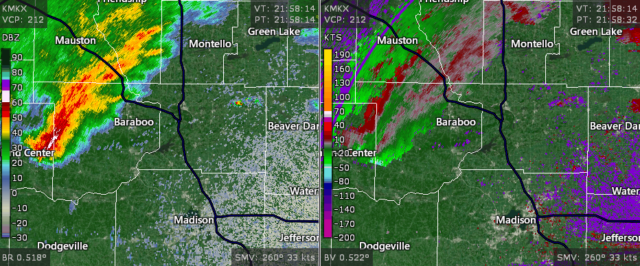
MKX radar loop zoomed into the storm that tracked through Baraboo in Sauk County Wednesday evening This storm produced damaging wind and large hail |
Hail
The storm that tracked through Sauk County Wednesday afternoon dropped hail at least the size of quarters in the North Freedom and Baraboo areas.
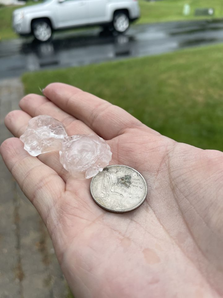 |
| Quarter-size Hail in Baraboo at 5:28 PM |
Radar / Rainfall:
 |
|
Estimated Rainfall Totals for Southern Wisconsin Wednesday and Wednesday Night |
Storm Reports
PRELIMINARY LOCAL STORM REPORT...SUMMARY
NATIONAL WEATHER SERVICE MILWAUKEE/SULLIVAN WI
224 PM CDT THU JUL 15 2021

..TIME...   ...EVENT...      ...CITY LOCATION...     ...LAT.LON...
..DATE...   ....MAG....      ..COUNTY LOCATION..ST.. ...SOURCE....
            ..REMARKS..

0528 PM     HAIL             1 NW BARABOO            43.48N 89.75W
07/14/2021  E1.00 INCH       SAUK               WI   BROADCAST MEDIA

            REPORT RELAYED VIA SOCIAL MEDIA. TIME
            ESTIMATED VIA RADAR.

0530 PM     TSTM WND DMG     BARABOO                 43.47N 89.74W
07/14/2021                   SAUK               WI   911 CALL CENTER

            MULTIPLE REPORTS OF DOWNED TREES, LIMBS, AND
            POWERLINES ACROSS BARABOO AND THE
            SURROUNDING AREAS. TIME ESTIMATED BASED ON
            RADAR.

0545 AM     HEAVY RAIN       3 ESE BARABOO           43.46N 89.68W
07/15/2021  M2.28 INCH       SAUK               WI   COCORAHS

            COCORAHS STATION WI-SK-26 BARABOO 3.2 ESE.

0700 AM     HEAVY RAIN       6 SE LAKE DELTON        43.54N 89.68W
07/15/2021  M2.20 INCH       SAUK               WI   COCORAHS

            COCORAHS STATION WI-SK-17 BARABOO 6.0 NNE.

1247 AM     TSTM WND DMG     BELOIT                  42.52N 89.02W
07/15/2021                   ROCK               WI   911 CALL CENTER

            MULTIPLE REPORTS OF TREES AND POWER LINES
            DOWN IN THE BELOIT AREA. TIME ESTIMATED FROM
            RADAR.

0505 AM     HEAVY RAIN       1 NE BERLIN             43.98N 88.94W
07/15/2021  M3.83 INCH       GREEN LAKE         WI   MESONET

            MESONET STATION BERLN BERLIN.

0644 AM     HEAVY RAIN       5 ESE BLANCHARDVILLE    42.79N 89.76W
07/15/2021  M1.14 INCH       GREEN              WI   COCORAHS

            COCORAHS STATION WI-GN-11 BLANCHARDVILLE 5.4
            ESE.

0630 AM     HEAVY RAIN       1 W BRODHEAD            42.62N 89.39W
07/15/2021  M1.54 INCH       GREEN              WI   CO-OP OBSERVER

            CO-OP OBSERVER STATION BROW3 BRODHEAD.

0641 AM     HEAVY RAIN       2 ENE BELLEVILLE        42.87N 89.50W
07/15/2021  M1.02 INCH       DANE               WI   MESONET

            MESONET STATION BKNW3 BROOKLYN.

0700 AM     HEAVY RAIN       4 NNW DUNDEE            43.71N 88.20W
07/15/2021  M1.61 INCH       FOND DU LAC        WI   COCORAHS

            COCORAHS STATION WI-DL-24 CAMPBELLSPORT 8.7
            NNE.

0705 AM     HEAVY RAIN       3 SW GERMANTOWN         43.20N 88.16W
07/15/2021  M1.27 INCH       WASHINGTON         WI   MESONET

            MESONET STATION FW6268 COLGATE.

0702 AM     HEAVY RAIN       3 NNE RILEY             43.06N 89.60W
07/15/2021  M1.20 INCH       DANE               WI   MESONET

            MESONET STATION AS276 4 SE CROSS PLAINS.

0128 AM     TSTM WND DMG     1 N DELAVAN             42.64N 88.63W
07/15/2021                   WALWORTH           WI   TRAINED SPOTTER

            MEDIUM SIZED TREE BRANCHES FALLEN AROUND
            NEIGHBORHOOD.

0705 AM     HEAVY RAIN       2 ENE DELAVAN LAKE      42.62N 88.58W
07/15/2021  M1.19 INCH       WALWORTH           WI   MESONET

            MESONET STATION FW8173 DELAVAN.

0655 AM     HEAVY RAIN       3 N WEST BARABOO        43.52N 89.77W
07/15/2021  M2.02 INCH       SAUK               WI   AWOS

            AWOS STATION KDLL DELLS BARABOO.

0511 AM     HEAVY RAIN       4 N DODGEVILLE          43.02N 90.14W
07/15/2021  M1.04 INCH       IOWA               WI   MESONET

            MESONET STATION DLEW3 DODGEVILLE.

0700 AM     HEAVY RAIN       3 SSE EDGERTON          42.79N 89.06W
07/15/2021  M1.04 INCH       ROCK               WI   MESONET

            MESONET STATION EW5754 EDGERTON.

0557 AM     HEAVY RAIN       3 ESE ROSENDALE         43.79N 88.62W
07/15/2021  M3.31 INCH       FOND DU LAC        WI   COCORAHS

            COCORAHS STATION WI-DL-18 ELDORADO 2.3 S.

0700 AM     HEAVY RAIN       2 ESE FOND DU LAC       43.77N 88.41W
07/15/2021  M3.60 INCH       FOND DU LAC        WI   COCORAHS

            COCORAHS STATION WI-DL-17 FOND DU LAC 1.7 E.

0653 AM     HEAVY RAIN       2 SW FOND DU LAC        43.77N 88.48W
07/15/2021  M2.37 INCH       FOND DU LAC        WI   ASOS

            ASOS STATION KFLD FOND DU LAC AIRPORT.

0700 AM     HEAVY RAIN       5 SW FORT ATKINSON      42.87N 88.91W
07/15/2021  M1.00 INCH       JEFFERSON          WI   COCORAHS

            COCORAHS STATION WI-JF-18 FORT ATKINSON 5.4
            SW.

0709 AM     HEAVY RAIN       GENOA CITY              42.50N 88.32W
07/15/2021  M1.06 INCH       WALWORTH           WI   MESONET

            MESONET STATION CW8307 GENOA CITY.

0333 PM     TSTM WND GST     2 SE GERMANTOWN         43.22N 88.09W
07/14/2021  E45 MPH          WASHINGTON         WI   TRAINED SPOTTER

            TREES ARE BENDING AND POWER IS FLICKERING.

0700 AM     HEAVY RAIN       1 E GREEN LAKE          43.84N 88.94W
07/15/2021  M2.77 INCH       GREEN LAKE         WI   COCORAHS

            COCORAHS STATION WI-GL-4 GREEN LAKE 0.8 E.

0630 AM     HEAVY RAIN       4 NW KEKOSKEE           43.57N 88.61W
07/15/2021  M1.47 INCH       DODGE              WI   MESONET

            MESONET STATION MAYW3 HORICON.

0700 AM     HEAVY RAIN       HOWARDS GROVE           43.83N 87.83W
07/15/2021  M2.98 INCH       SHEBOYGAN          WI   MESONET

            MESONET STATION FW1977 HOWARDS GROVE.

0700 AM     HEAVY RAIN       3 W JANESVILLE          42.68N 89.08W
07/15/2021  M1.25 INCH       ROCK               WI   COCORAHS

            COCORAHS STATION WI-RK-12 JANESVILLE 3.1 W.

0456 AM     HEAVY RAIN       6 SW JANESVILLE         42.62N 89.09W
07/15/2021  M2.06 INCH       ROCK               WI   COCORAHS

            COCORAHS STATION WI-RK-18 JANESVILLE 6.0 SW.

0700 AM     HEAVY RAIN       1 ENE LAKE GENEVA       42.59N 88.42W
07/15/2021  M1.15 INCH       WALWORTH           WI   COCORAHS

            COCORAHS STATION WI-WW-2 LAKE GENEVA 0.6
            ENE.

0525 PM     TSTM WND DMG     2 SSW LOGANVILLE        43.42N 90.05W
07/14/2021                   SAUK               WI   911 CALL CENTER

            *** 1 INJ ***
            REPORT OF ROOF DAMAGE TO A GARAGE ALONG WITH
            TREES DOWN ON SPRING VALLEY RD. TIME
            ESTIMATED VIA RADAR.

0700 AM     HEAVY RAIN       1 SSW MIDDLETON         43.08N 89.52W
07/15/2021  M1.01 INCH       DANE               WI   COCORAHS

            COCORAHS STATION WI-DA-46 MADISON 6.4 W.

0615 AM     HEAVY RAIN       3 N KEKOSKEE            43.57N 88.57W
07/15/2021  M1.15 INCH       DODGE              WI   COCORAHS

            COCORAHS STATION WI-DD-18 MAYVILLE 4.9 NNW.

0700 AM     HEAVY RAIN       1 NNE GREENFIELD        42.98N 88.00W
07/15/2021  M1.02 INCH       MILWAUKEE          WI   MESONET

            MESONET STATION FW7576 MILWAUKEE.

1155 PM     HEAVY RAIN       1 N GREENFIELD          42.98N 88.00W
07/14/2021  M1.25 INCH       MILWAUKEE          WI   COCORAHS

            COCORAHS STATION WI-MW-67 MILWAUKEE 6.0 SSW.

0706 AM     HEAVY RAIN       1 NNE MONONA            43.06N 89.33W
07/15/2021  M1.20 INCH       DANE               WI   MESONET

            MESONET STATION FW3620 MONONA.

0655 AM     HEAVY RAIN       3 ENE MONROE            42.62N 89.60W
07/15/2021  M1.17 INCH       GREEN              WI   AWOS

            AWOS STATION KEFT MONROE.

0515 AM     HEAVY RAIN       2 WSW MOUNT CALVARY     43.82N 88.28W
07/15/2021  M4.45 INCH       FOND DU LAC        WI   COCORAHS

            COCORAHS STATION WI-DL-5 MOUNT CALVARY 1.6
            WSW.

0705 AM     HEAVY RAIN       1 W MUSKEGO             42.89N 88.14W
07/15/2021  M1.05 INCH       WAUKESHA           WI   MESONET

            MESONET STATION AR976 MUSKEGO.

0500 AM     HEAVY RAIN       4 NW PRINCETON          43.90N 89.18W
07/15/2021  M2.92 INCH       MARQUETTE          WI   COCORAHS

            COCORAHS STATION WI-MQ-5 NESHKORO 5.0 SSE.

0700 AM     HEAVY RAIN       1 ESE NEW BERLIN        42.97N 88.12W
07/15/2021  M1.00 INCH       WAUKESHA           WI   COCORAHS

            COCORAHS STATION WI-WK-35 NEW BERLIN 0.6
            ESE.

0522 PM     TSTM WND DMG     NORTH FREEDOM           43.46N 89.86W
07/14/2021                   SAUK               WI   BROADCAST MEDIA

            MULTIPLE TREES DOWN IN NORTH FREEDOM. TIME
            ESTIMATED VIA RADAR.

0514 AM     HEAVY RAIN       2 N PARDEEVILLE         43.56N 89.31W
07/15/2021  M1.97 INCH       COLUMBIA           WI   MESONET

            MESONET STATION PEEW3 PARDEEVILLE.

0608 AM     HEAVY RAIN       1 ESE PELL LAKE         42.53N 88.33W
07/15/2021  M1.26 INCH       WALWORTH           WI   CO-OP OBSERVER

            CO-OP OBSERVER STATION PLLW3 1.4 E PELL
            LAKE.

0700 AM     HEAVY RAIN       4 WSW HOWARDS GROVE     43.81N 87.91W
07/15/2021  M2.47 INCH       SHEBOYGAN          WI   COCORAHS

            COCORAHS STATION WI-SB-18 PLYMOUTH 5.4 NE.

0545 PM     TSTM WND DMG     6 SW PORTAGE            43.48N 89.54W
07/14/2021                   COLUMBIA           WI   911 CALL CENTER

            REPORTS OF DOWNED TREES AND LIMBS AROUND THE
            CALEDONIA AREA IN COLUMBIA COUNTY. TIME
            ESTIMATED VIA RADAR.

0600 AM     HEAVY RAIN       6 WSW PORTAGE           43.51N 89.57W
07/15/2021  M2.10 INCH       COLUMBIA           WI   COCORAHS

            COCORAHS STATION WI-CB-4 PORTAGE 5.7 WSW.

0700 AM     HEAVY RAIN       7 SW PORTAGE            43.48N 89.57W
07/15/2021  M2.17 INCH       COLUMBIA           WI   COCORAHS

            COCORAHS STATION WI-CB-5 PORTAGE 7.2 SW.

0555 PM     TSTM WND DMG     1 NE POYNETTE           43.40N 89.40W
07/14/2021                   COLUMBIA           WI   911 CALL CENTER

            REPORTS OF DOWNED TREES AND LIMBS AROUND THE
            POYNETTE AREA. TIME ESTIMATED VIA RADAR.

0525 AM     HEAVY RAIN       1 N REEDSBURG           43.55N 90.00W
07/15/2021  M2.74 INCH       SAUK               WI   COCORAHS

            COCORAHS STATION WI-SK-15 REEDSBURG 1.3 N.

0706 AM     HEAVY RAIN       1 SW RIPON              43.84N 88.85W
07/15/2021  E2.75 INCH       FOND DU LAC        WI   PUBLIC


0700 AM     HEAVY RAIN       2 NW ROCK SPRINGS       43.50N 89.94W
07/15/2021  M2.43 INCH       SAUK               WI   COCORAHS

            COCORAHS STATION WI-SK-24 ROCK SPRINGS 1.6
            NW.

0700 AM     HEAVY RAIN       3 WSW ROCK SPRINGS      43.46N 89.97W
07/15/2021  M1.97 INCH       SAUK               WI   COCORAHS

            COCORAHS STATION WI-SK-2 ROCK SPRINGS 2.8
            WSW.

0600 AM     HEAVY RAIN       1 W SHEBOYGAN           43.75N 87.72W
07/15/2021  M1.53 INCH       LMZ643             WI   COCORAHS

            COCORAHS STATION WI-SB-27 SHEBOYGAN 0.6 NNE.

0700 AM     HEAVY RAIN       3 N KOHLER              43.78N 87.77W
07/15/2021  M3.25 INCH       SHEBOYGAN          WI   COCORAHS

            COCORAHS STATION WI-SB-12 SHEBOYGAN 3.2 NW.

0700 AM     HEAVY RAIN       3 SSE KOHLER            43.70N 87.75W
07/15/2021  M1.21 INCH       SHEBOYGAN          WI   COCORAHS

            COCORAHS STATION WI-SB-31 SHEBOYGAN 3.3 SSW.

0653 AM     HEAVY RAIN       3 SSW HOWARDS GROVE     43.78N 87.85W
07/15/2021  M3.04 INCH       SHEBOYGAN          WI   ASOS

            ASOS STATION KSBM SHEBOYGAN-AIRPORT.

0652 AM     HEAVY RAIN       6 N SHIRLAND            42.53N 89.21W
07/15/2021  M2.32 INCH       ROCK               WI   PUBLIC


0504 AM     HEAVY RAIN       SHOREWOOD               43.09N 87.88W
07/15/2021  M1.43 INCH       MILWAUKEE          WI   MESONET

            MESONET STATION SORWD SHOREWOOD.

1200 AM     HEAVY RAIN       2 ESE SOUTH BYRON       43.63N 88.45W
07/15/2021  M2.13 INCH       FOND DU LAC        WI   CO-OP OBSERVER

            CO-OP OBSERVER STATION FDCW3 1.8 E SOUTH
            BYRON.

0600 AM     HEAVY RAIN       4 SSW SOUTH WAYNE       42.51N 89.90W
07/15/2021  M1.58 INCH       LAFAYETTE          WI   COCORAHS

            COCORAHS STATION WI-LF-6 SOUTH WAYNE 3.9
            SSW.

0610 AM     HEAVY RAIN       ST. PETER               43.83N 88.35W
07/15/2021  M4.30 INCH       FOND DU LAC        WI   CO-OP OBSERVER

            CO-OP OBSERVER STATION TAHW3 ST. PETER.

0706 AM     HEAVY RAIN       2 ESE MAPLE BLUFF       43.10N 89.33W
07/15/2021  M1.14 INCH       DANE               WI   MESONET

            MESONET STATION EW4463 SUN PRAIRIE.

0700 AM     HEAVY RAIN       THERESA                 43.52N 88.45W
07/15/2021  M1.14 INCH       DODGE              WI   COCORAHS

            COCORAHS STATION WI-DD-14 THERESA 0.1 ESE.

0700 AM     HEAVY RAIN       THERESA                 43.51N 88.46W
07/15/2021  M1.18 INCH       DODGE              WI   COCORAHS

            COCORAHS STATION WI-DD-6 THERESA 0.5 SSW.

0700 AM     HEAVY RAIN       6 WNW LA VALLE          43.63N 90.24W
07/15/2021  M2.02 INCH       SAUK               WI   COCORAHS

            COCORAHS STATION WI-SK-25 WONEWOC 2.0 SSW.
 |
Media use of NWS Web News Stories is encouraged! Please acknowledge the NWS as the source of any news information accessed from this site. |
|

