Hurricane Ophelia - September 14-15, 2005
Event Overview
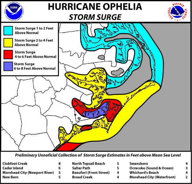
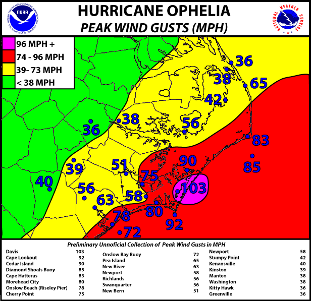
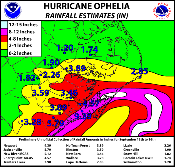
On September 14-15, 2005 Hurricane Ophelia raked the southeast North Carolina coast from Cape Fear north to the Outer Banks. Although the eye never came ashore, the eyewall stayed over much of the coast for up to 24-36 hours. The strong winds in the eyewall caused significant damage in coastal areas such as Morehead City, Beaufort, Atlantic Beach, Emerald Isle, the rest of Bogue Banks and downeast Carteret County. Wind damage was primarily limited to Carteret County where winds partially destroyed a few structures, ripped off roofs, shingles, and knocked down trees and fences. Winds gusted to 83 mph at Cape Hatteras (KHSE), 93 mph at Cedar Island, 63 mph in Beaufort (KMRH) (before ASOS outage), 75 mph at Cherry Point (KNKT), 51 mph in New Bern (KEWN), 63 mph in Jacksonville (KNCA), 92 mph at Cape Lookout (CLKN7), 72 mph at the Onslow Bay Buoy (41035), 78 mph at Frying Pan Buoy (41013) and 85 mph at the Diamond Buoy (41025). Off-Duty NWS employees estimated that winds along Bogue Banks (in Emerald Isle, about 4 miles east of the Hwy 58 bridge to mainland Carteret County) were 60-70 mph sustained with gusts to 80 mph, primarily between 7:00-9:00 pm EDT on Wednesday, September 14th. Flooding from excessive rainfall was minimal and primarily limited to ponding of water in low-lying areas. Storm total rainfall amounts from Tuesday 9/13/05 through Friday 9/16/05 were likely between 5 and 10". 9.39" of rain fell at the NWS Weather Forecast Office in Newport. Storm total rainfall amounts of up to a foot were likely in isolated locations. Flooding from storm surge was more significant, inundating many portions of the coast, especially in areas on the western side of the Pamlico Sound and along the Neuse, Pamlico and Newport rivers. Water levels in Beaufort County (near Washington) along the Pamlico River reached 4 feet above normal. New Bern reached 5 feet above normal. Locations along the lower Neuse River in Craven County reported water levels of 8-9 feet above normal. Areas along the Newport River just north of Morehead City experienced water levels 4-5 feet above normal, while portions of Beaufort had water levels about 4 feet above normal and the Morehead City waterfront saw a 2 foot surge. Salter Path along Bogue Banks saw a 5 foot sound-side surge. The winds and flooding observed in Hurricane Ophelia were below that seen in Hurricane Isabel on September 18, 2003. However, areas along Bogue Banks from Emerald Isle east to Atlantic Beach experienced higher winds than in Isabel.
Ophelia's History
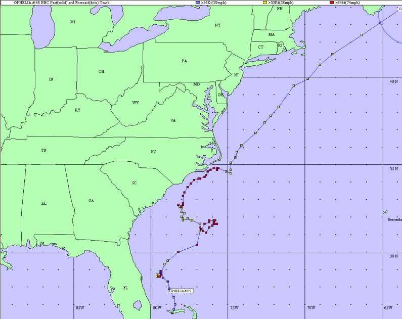
Hurricane Ophelia began off the coast of Florida in the northwestern Bahamas as Tropical Depression 16 on Tuesday, September 6, 2005. By 2:00 am Wednesday, September 7, 2005, Tropical Depression 16 officially became Tropical Storm Ophelia with sustained winds of 40 mph and a central pressure of 1003 mb. At 5:00 pm on Thursday, September 8, 2005 Ophelia became the 7th hurricane of the season with maximum sustained winds of 75 mph and a central pressure of 985 mb. Ophelia continued to meander off the FL coast through Friday September 9, weakening to a Tropical Storm by the 2:00 am advisory with maximum sustained winds of 65 mph and a minimum central pressure of 991 mb. By 5:00 pm on the same day, Ophelia regained Hurricane strength and it was headlined in the National Hurricane Center forecast that Ophelia could become a threat to the Southeast U.S. coast as she continued to meander off the FL/SC coast. At 5:00 am Saturday, September 10 Ophelia again weakened to a Tropical Storm with 70 mph sustained winds and a minimum central pressure of 984 mb. Ophelia regained Hurricane strength by 11:00 am the same morning. At 2:00 pm on Saturday afternoon a Hurricane Watch was issued for the southeast U.S. coast from the Savannah River in SC north to Cape Lookout, NC. Ophelia continuned to meander with a slow WNW motion off the SC coast on Sunday, September 11th as a Category 1 Hurricane with sustained winds of 75 mph and a minimum central pressure of 978 mb. At 5:00 pm on Sunday a Tropical Storm Warning was issued from the South Santee River in SC north to Cape Lookout, NC. As Ophelia continued to meander off the SC coast, she again weakened to a Tropical Storm on Monday, September, 12th at 11:00 am. At 11:00 pm on Monday, a Hurricane Warning was issued for the South Santee River in SC north to Cape Lookout, NC. Although Ophelia was a strong Tropical Storm still at this time, she was expected to strengthen over the next 24 hours, and, indeed, she did. At 5:30 pm on Tuesday, September 13th, Ophelia regained Hurricane strength over the Gulf Stream off the SC/NC coast and the Hurricane Warning was extended north to Oregon Inlet along the northern Outer Banks.
By 2:00 am on Wednesday, September 14th, Ophelia was located 100 miles south of Wilmington, NC. By 8:00 am, Ophelia was located 60 miles south of Wilmington, NC or 110 miles southwest of Cape Lookout, NC with maximum sustained winds of 80 mph. The eye of Hurricane Ophelia passed directly over buoy 41013 around this time The eyewall of Ophelia subsequently rotated along southeast North carolina from Wilmington north to Cape Hatteras over the next 24-36 hours. By 2:00 pm on Wednesday, sustained winds had increased to 85 mph and Ophelia was an impressive Category 1 Hurricane with good satellite and radar representation and a minimum central pressure of 979 mb. The large eye of Opehlia stayed offshore and never crossed over land. Hurricane-force or near hurricane-force sustained winds and gusts to 85-90 mph were seen in many locations along Bogue Banks and downeast Carteret County north to Cape Hatteras. Ophelia continued to lash the NC coast through the day on Thursday, September 15, with winds finally subsiding from Surf City north to Bogue Banks and downeast Carteret County by early [Thursday 09/15/05] afternoon. However, Ophelia continued to affect areas from Cape Lookout north to Oregon Inlet through Thursday (9/15/05) evening and into early Friday (9/16/05) morning.
Click HERE for other information on Hurricane Ophelia from NOAA.
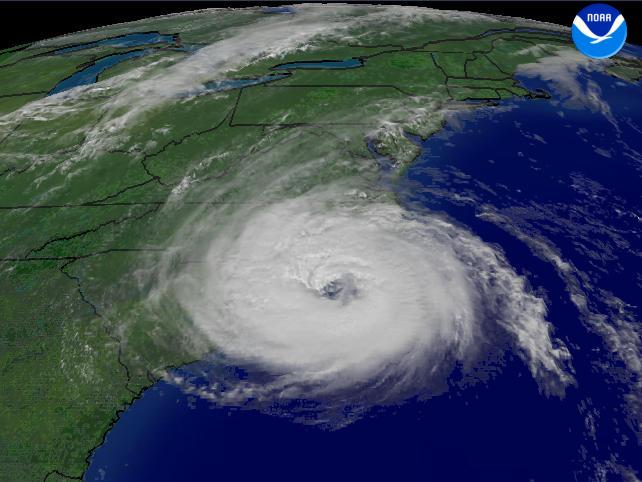
Hazard Graphics - Geographical maps portraying Hurricane Ophelia's track (first), the highest storm surge (second), wind gusts (third) and rainfall (fourth) from 09/14/05 through 09/15/05 throughout the NWS Newport/Morehead City County Warning Area (CWA) are shown below. A table containing the date and time of max wind gusts, sustained winds, minimum barometric pressure and rainfall amounts for all land-based stations, buoys and COOP sites in the NWS MHX CWA is also linked below.
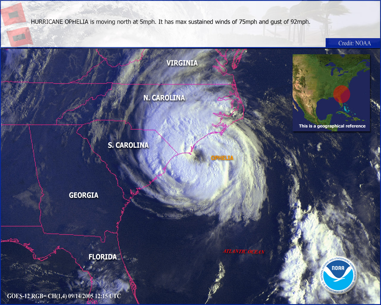
Satellite Imagery - Visible satellite imagery from 1215Z (8:15 am EDT) September 14, 2005.
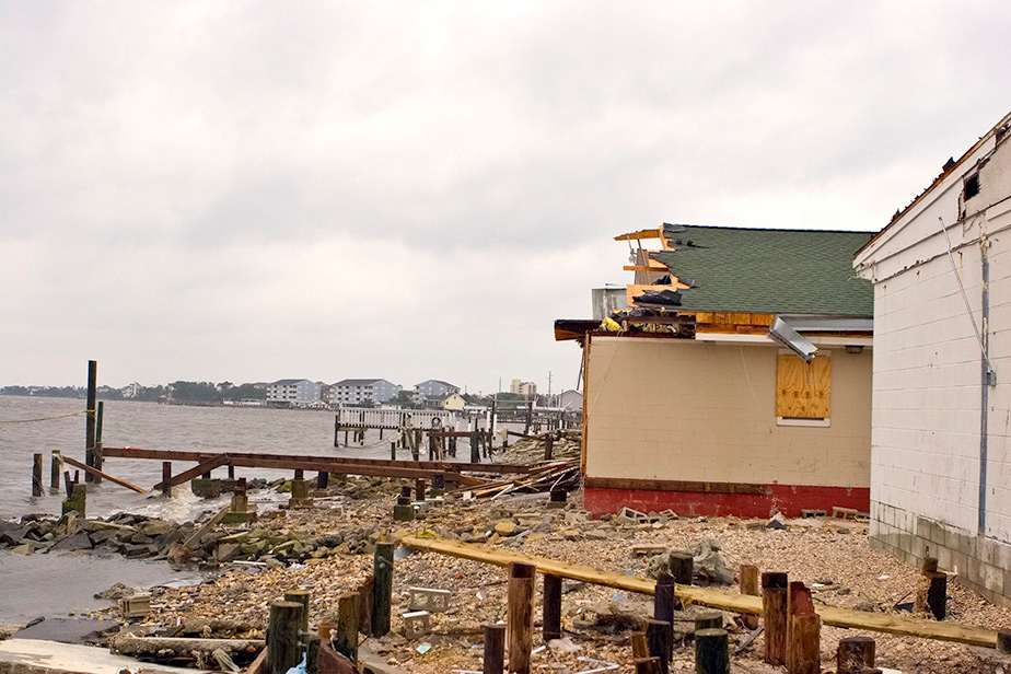
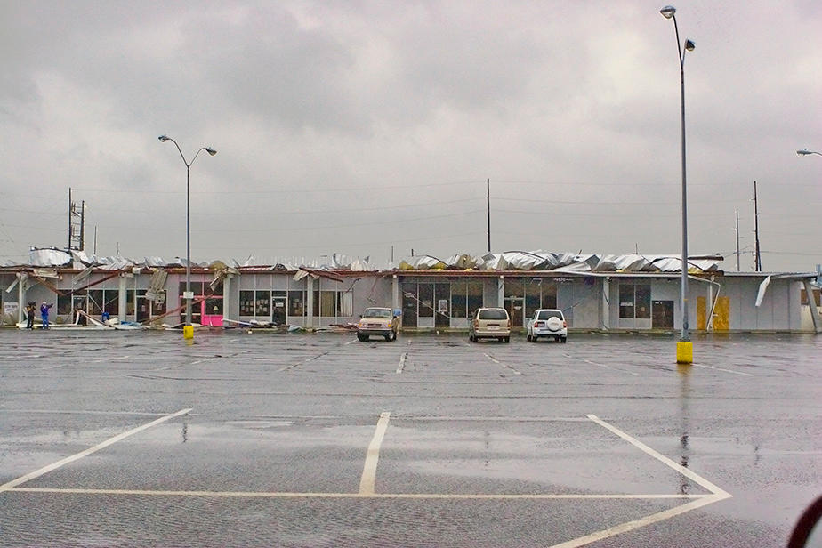
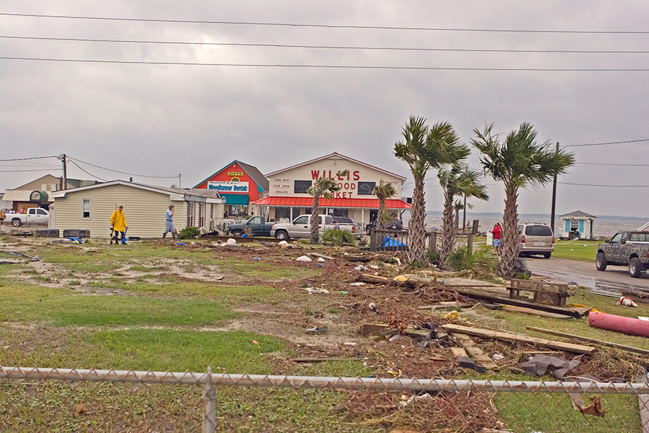
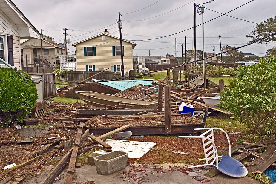
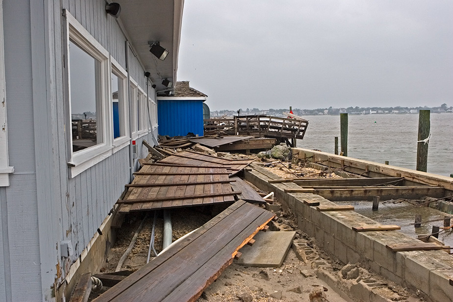
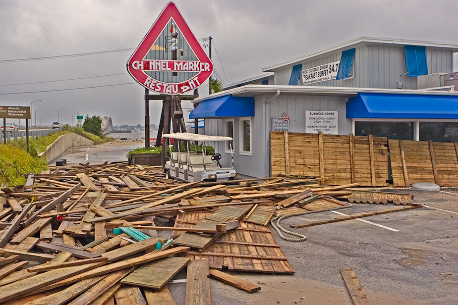
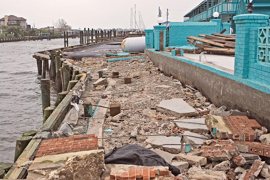
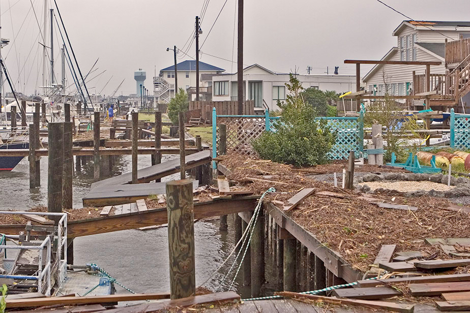
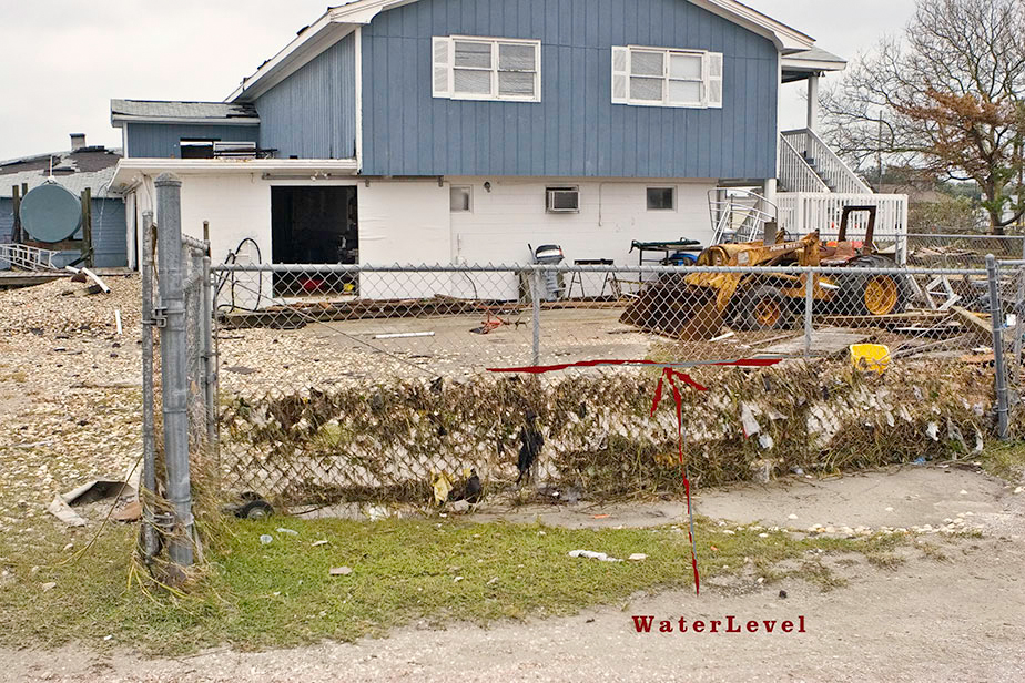
Damage Pictures from central and eastern Bogue Banks area
Photos courtesy of Gil Wagi and Rich Bandy, NWS MHX


Case Study Team:
Brandon Vincent
Rich Bandy


.png) Surf Forecast/Rip Currents
Surf Forecast/Rip Currents Map View
 Weather Hazard Briefing (when applicable)
 Forecaster Discussion
 Marine
 Text Products
.png) Skywarn
Skywarn Submit Storm Reports
 Coastal Flood
 Follow us on YouTube