Event Overview
Shallow convection during the early evening hours of March 27, 2009 produced a pair of tornadoes in the coastal plain portion of the NWS weather forecast office in Newport/Morehead City’s (WFO MHX) County Warning Area (CWA). The storms formed south of a slow moving frontal boundary that had assisted in producing widespread rain over the area much of the morning and early afternoon hours. The main area of rain that affected the area early in the day had largely moved over the counties adjacent to the Albemarle Sound by late in the afternoon. This led to some gaps in the clouds especially over Duplin, Onslow, Jones, Greene, Craven, and Carteret Counties mainly after 2:00 pm EDT. The filtered sunshine helped produce an area of enhanced instability over the SW part of the WFO MHX CWA. This combined with increasing low level shear, low LCL’s, the frontal boundary, and an approaching upper level disturbance helped trigger the tornadoes that occurred over Greene and Pitt counties.
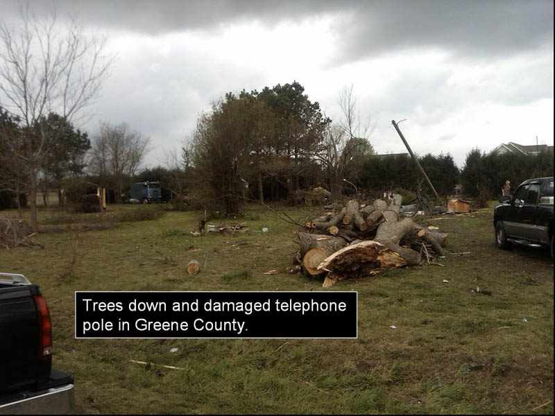
An NWS damage survey team concluded that an EF-1 tornado with winds estimated between 105 to 110 MPH touched down approximately 2 miles west of Hookerton in Greene county, and had a path length around 1 ½ mile. Several homes received minor to moderate roof damage, pine trees were snapped, windows were blown out of residences, and a light truck was spun around. The team estimated that a separate EF1 tornado with winds at 85 to 90 mph touched down in Pitt County near Firetower Road near Greenville, and had a path length between ¼ to ½ mile. This tornado caused minor damage to approximately 40 homes and downed some small trees. Luckily, no deaths or injuries were reported.
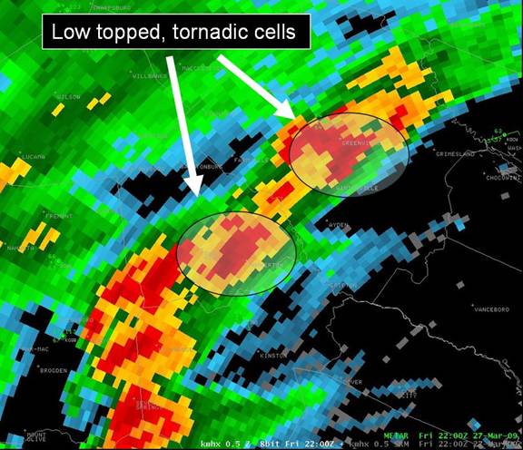
Figure 1. 0.5 degree base reflectivity from KMHX at 22Z 27 March 2009.
Synoptic and Mesoscale Overview
A. The Main Players
A cold front moved south into eastern North Carolina during the morning hours of March 27, 2009. The boundary then stalled across the area generally between the Central Outer Banks and Pitt County during the afternoon and evening hours (Figure 2). Aloft, the area was initially influenced by short wave ridging within mean SW flow. However, a well defined mid level short wave trough approached the area late in the afternoon from the SW (Figure 3). Lift ahead of this feature associated with positive vorticity advection undoubtedly enhanced vertical motion over eastern North Carolina.
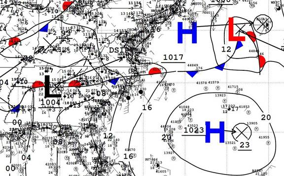
Figure 2. NCEP Unified Surface Analysis from 00Z March 28 2009 showing slow moving front over eastern North Carolina.
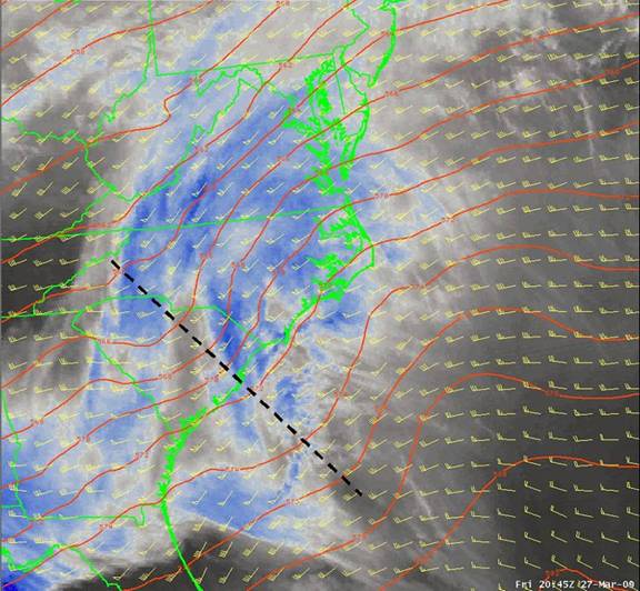
Figure 3. Water Vapor imagery at 20:45Z Friday 27 March 2009. NAM 12 (18z run 3/27/09) 500mb heights overlaid in red and wind vectors in yellow. Dashed black line is mean location of short wave trough axis.
B. Instability and Shear
Minimal instability affected the WFO MHX CWA most of the day given widespread cloudiness over the area. The atmosphere was marginally unstable just offshore near the Gulf Stream most of the morning and afternoon, but no thunderstorms developed in this region. An area of light to moderate precipitation affected much of the northern half of the WFO MHX CWA before 3pm, then pushed NE over the Northern Outer Banks, areas near the Albemarle sound, and eventually offshore into the Atlantic. The dense cloudiness thinned in wake of this precipitation and led to some filtered sunshine over much of Duplin, Greene, Onslow, Jones, Carteret, and Craven counties late in the afternoon. This same area was in the warm sector south of the stalled frontal boundary noted in Figure 2. As a result, surface based lifted indices diminished from near zero to between -2 to -4 after 20Z (Figure 4). Surface based CAPE meanwhile increased to 400-600 J/kg (Figure 5). The available computer model guidance was much more stable at this time frame.
Even though instability increased, it was still marginal and significant convection was not anticipated. However, shear parameters were more than sufficient to promote rotating updrafts. Low level shear (0-1km) increased steadily between 18z-00Z from 15-20 kt to 25-35 kt (Figure 6). LAPS surface helicity values also increased into the 150-200 m2/s2 range (Figure 5). In addition, LCL values were below 1500 ft. This environment was favorable for the low topped super cells and corresponding tornadoes that developed.
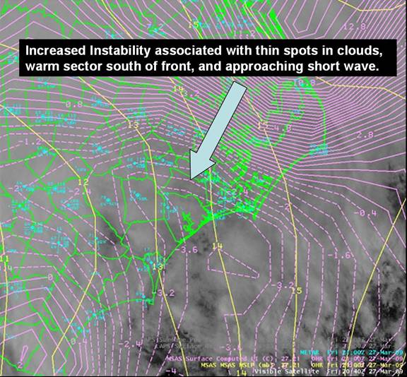
Figure 4. Visible Satellite Imagery and MSAS Lifted Index (pink lines) and mean sea level pressure (yellow lines) from 2040Z.
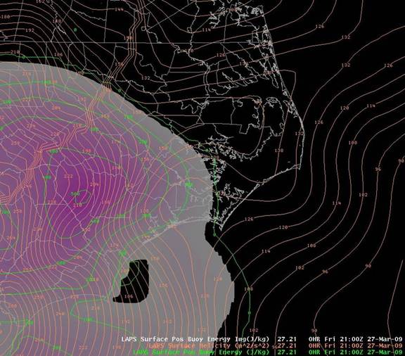
Figure 5. LAPS surface CAPE (shaded) and Helicity (orange countours) from 21Z 27 March 2009.
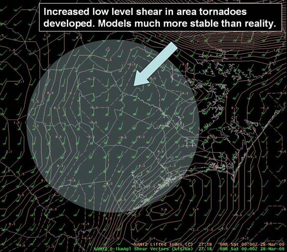
Figure 6. NAM12 lifted indices and 0-1km shear vectors from 00Z 28 March 2009.
C. Radar Data
Convective showers increased in coverage and intensity across eastern South Carolina and SE North Carolina after 3pm (19Z) due to the features discussed in sections A and B above. Very little lightning was observed given the marginal instability across the area, and echo tops generally did not exceed 20-25 kft. However, individual cells occasionally exhibited supercell characteristics. Pronounced low level couplets associated with the Greene and Pitt county tornadoes were observed from both the Raleigh and Morehead City/Newport radars between approximately 2140-2240Z. The strongest rotational couplets and gate to gate shear was noted at 22Z (Figure 7). Tornado warnings were issued for both of these storms prior to any damage reports or tornado touchdown visuals received. It should be noted that upstream reports of confirmed tornadoes in adjacent CWA’s just prior to this event were very helpful in the warning process.
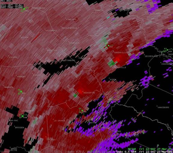
Figure 7. 0.5 degree Storm Relative Velocity from KMHX at 22Z 27 March 2009 showing strong rotational couplets just west of Hookerton in Greene County and just S of Greenville in Pitt County.
Damage Survey
The NWS WFO MHX damage survey team determined that both tornadoes during the evening hours of March 27, 2009 were EF1's. The tornado that affected Greene County touched down approximately 2 miles west of Hookerton along the intersection of Shady Grove Church Road and SR 1436. It moved northeast for 1.5 miles to near the intersection of Dixon Farm Road and SR 1437. This was a high end EF1 with winds estimated from damage of 105 to 110 mph. Several homes received minor to moderate roof damage, pines trees layed down and snapped, one large hardwood tree down, windows were blown out of residences, and a light truck was spun around. There were no deaths or injuries. An interview conducted with a resident of a manufactured home took refuge in an interior closet during the tornado. His blue truck was spun around and home was damaged.
The Pitt County Tornado that affected communities near Greenville was determined to be a low end EF1 with winds estimated from damage of 85 to 90 mph. This tornado struck a more populated area causing minor damage to approximately 40 homes. Shingles were off roofs, debris blown into roofs, siding taken off homes, and some small trees were down. This tornado started out at Dudleys Grant Road, crossed Firetower Road. moving northeast, and affected a subdivision along Ashcroft Drive. The tornado damage path was approximately 100 yards wide, and was on the ground for 1/4 to 1/2 mile. Damages were estimated at $200,000. There were no deaths or injuries.
In addition to archived radar data, the Google Earth based rotational track product produced by the National Severe Storms Laboratory (NSSL) in Norman, OK proved invaluable in the damage review (Figure 8). This and damage pictures are shown below.
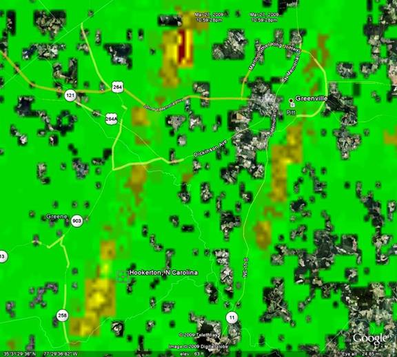
Figure 8. NSSL rotational track product from March 27, 2009.
Damage Pictures from Greene and Pitt Counties: March 27, 2009
Photos Courtesy of John Cole, WCM WFO MHX.


Case Study Team
John Cole
Bob Frederick
Jeremy Schulz
Jim Merrell
Mark Willis


.png) Surf Forecast/Rip Currents
Surf Forecast/Rip Currents Map View
 Weather Hazard Briefing (when applicable)
 Forecaster Discussion
 Marine
 Text Products
.png) Skywarn
Skywarn Submit Storm Reports
 Coastal Flood
 Follow us on YouTube