Event Overview
Widespread large hail was observed over Eastern North Carolina during the late afternoon hours of Monday June 12, 2006. The severe weather lasted from roughly 3:30 pm to 6 pm, with Craven and Pamlico Counties being particularly hard hit. Softball sized hail, up to 4.25 inches in diameter, was observed in the New Bern area causing widespread damage, especially to vehicles. The storm also hit agriculture hard with Pamlico County Extension Service reporting damage to 879 acres. The crops affected included corn, tobacco, cotton and soybeans. There were additionally reports of minor wind damage across the region. These severe reports were part of a larger area of severe weather that covered a large portion of the Carolinas (Figure 1).
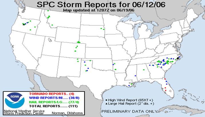
Figure 1. Severe Weather Reports from June 12, 2006
Synoptic Overview
As of 12Z Monday June 12, 2006, the 500 mb analysis (Figure 2) showed a mid-level trough moving east from the Appalachians east-southeastward across the Carolinas. At the surface, an east-west oriented cold front was slowly drifting across Eastern North Carolina at late morning (Figure 3). The 12Z Newport/Morehead City upper-air sounding showed a moist, unstable pre-storm environment (Figure 4). The low levels continued to warm/destabilize south of the boundary with surface dewpoints in the 70s and CAPE (Convective Available Potential Energy) values ranging from 1500 to 2500 J/kg. This instability led to a Severe Thunderstorm Watch being issued at 1:45 pm effective through 8 pm in the evening (Figure 5). In addition to the instability, a band of 35 to 50 knot mid-level flow above the surface frontal zone provided sufficient vertical shear for organized severe storms to develop. In fact, the scattered convection developed into a large mesoscale convective system (MCS) with numerous large hail and wind reports.
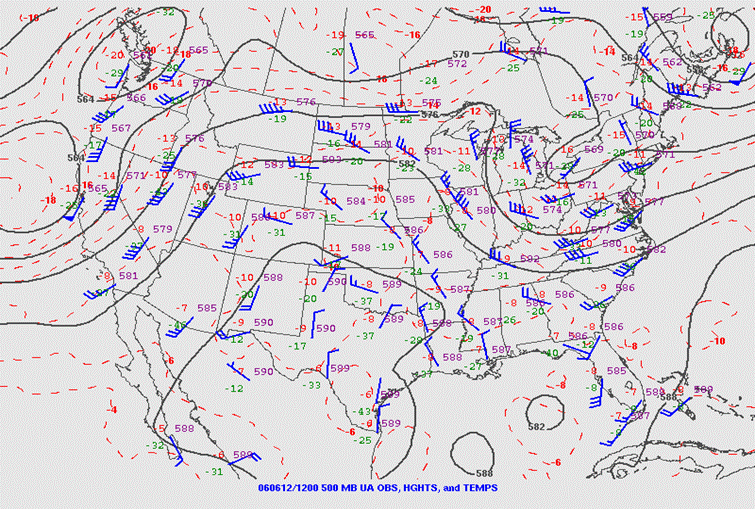
Figure 2. 500 mb Analysis at 12Z June 12, 2006 showing a mid-level trough moving from the Appalachians across the Carolinas.
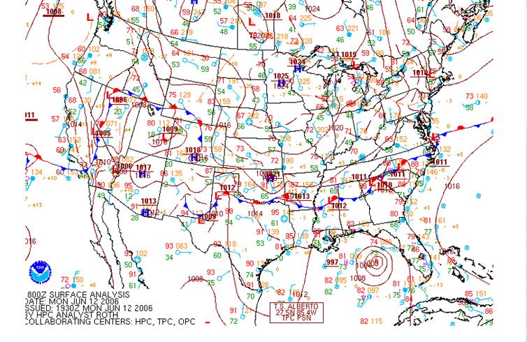
Figure 3. Surface Map at 15Z June 12, 2006 showing slow-moving cold front across Eastern North Carolina.
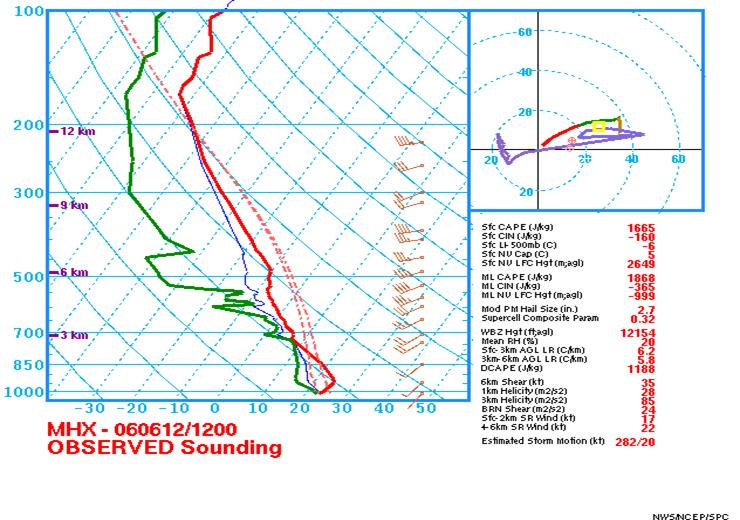
Figure 4. The 12Z Newport/Morehead City upper-air sounding showed a moderately unstable pre-storm environment.
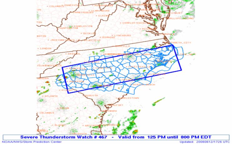
Figure 5. A Severe Thunderstorm Watch was issued at 1:25 pm June 12, 2006, for most of Eastern North Carolina.
Radar Analysis
The initial report of dime-sized hail came from Richlands in Onslow County at 3:33 pm and hail reports continued to come in through 6 pm. Five reports of hail of greater than 2 inches were received with the largest being a very rare 4.25 inch (softball-sized) hail report from James City in Craven County around 4:55 pm. One of the best indicators of large hail is the Vertically Intergrated Liquid (VIL) product from the WSR-88D NEXRAD radar. Vertically Integrated Liquid is an estimate of the total mass of precipitation in the clouds. Higher VIL values are usually well-correlated with large hail. VIL values in excess of 70 kg/m2 were observed near New Bern/James City as the softball sized hail was reported (Figure 6). High reflectivity cores were observed at multiple elevation angles throughout the storm (Figure 7). The storm also exhibited a tilted updraft as shown in this reflectivity cross section (Figure 8). This was due to unidirectional wind shear, which enabled the storm to remain severe, producing large hail, throughout its track.
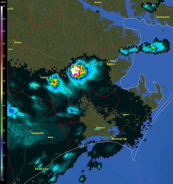
Figure 6. Newport/Morehead City radar depiction of Vertically Integrated Liquid (VIL). Higher values of VIL typically correlate well with large hail. Note the large area of VIL over 70 kg/m2 near New Bern around 2045Z June 12, 2006.
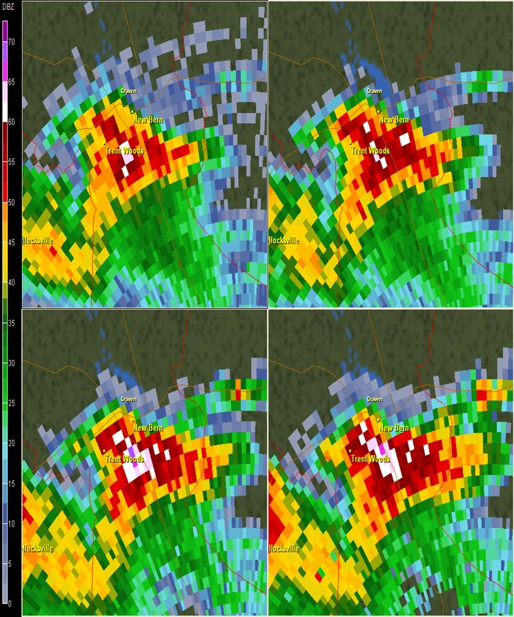
Figure 7. A four-panel reflectivity view from the Newport/Morehead City WSR-88D radar showing high reflectivity values at 0.5, 1.5, 2.4 and 3.4 degrees elevation slices.
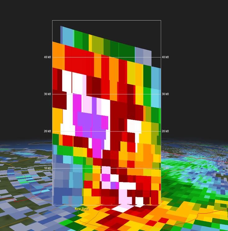
Figure 8. Radar cross-section showing a tilted updraft and a 70 dbZ core in excess of 35000 ft, indicative of a severe supercell storm.
PRELIMINARY LOCAL STORM REPORT...SUMMARY
NATIONAL WEATHER SERVICE NEWPORT/MOREHEAD CITY NC
1012 PM EDT MON JUN 12 2006
..TIME... ...EVENT... ...CITY LOCATION... ...LAT.LON...
..DATE... ....MAG.... ..COUNTY LOCATION..ST.. ...SOURCE....
..REMARKS..
0333 PM HAIL RICHLANDS 34.90N 77.55W
06/12/2006 E0.75 INCH ONSLOW NC PUBLIC
0334 PM HAIL RICHLANDS 34.90N 77.55W
06/12/2006 E0.88 INCH ONSLOW NC PUBLIC
0345 PM HAIL RICHLANDS 34.90N 77.55W
06/12/2006 E0.75 INCH ONSLOW NC PUBLIC
0413 PM HAIL ROSE HILL 34.83N 78.03W
06/12/2006 E0.25 INCH DUPLIN NC PUBLIC
0441 PM HAIL TRENT WOODS 35.08N 77.10W
06/12/2006 E0.88 INCH CRAVEN NC TRAINED SPOTTER
0442 PM HAIL JAMES CITY 35.07N 77.02W
06/12/2006 E1.00 INCH CRAVEN NC PUBLIC
0444 PM HAIL TRENT WOODS 35.08N 77.10W
06/12/2006 E0.75 INCH CRAVEN NC PUBLIC
0445 PM HAIL NEW BERN 35.12N 77.08W
06/12/2006 E1.75 INCH CRAVEN NC PUBLIC
0445 PM HAIL 3 S NEW BERN 35.08N 77.08W
06/12/2006 E1.75 INCH CRAVEN NC TRAINED SPOTTER
0445 PM HAIL TRENT WOODS 35.08N 77.10W
06/12/2006 E0.25 INCH CRAVEN NC PUBLIC
0446 PM HAIL TRENT WOODS 35.08N 77.10W
06/12/2006 E0.88 INCH CRAVEN NC PUBLIC
0449 PM HAIL NEW BERN 35.12N 77.08W
06/12/2006 E1.50 INCH CRAVEN NC NWS EMPLOYEE
0449 PM HAIL 3 S NEW BERN 35.08N 77.08W
06/12/2006 E1.00 INCH CRAVEN NC PUBLIC
0449 PM HAIL NEW BERN 35.12N 77.08W
06/12/2006 E1.00 INCH CRAVEN NC TRAINED SPOTTER
0450 PM HAIL NEW BERN 35.12N 77.08W
06/12/2006 E0.88 INCH CRAVEN NC PUBLIC
0450 PM HAIL NEW BERN 35.12N 77.08W
06/12/2006 E1.00 INCH CRAVEN NC PUBLIC
0450 PM HAIL NEW BERN 35.12N 77.08W
06/12/2006 E1.00 INCH CRAVEN NC PUBLIC
0450 PM HAIL NEW BERN 35.12N 77.08W
06/12/2006 E1.00 INCH CRAVEN NC PUBLIC
0452 PM HAIL NEW BERN 35.12N 77.08W
06/12/2006 E1.75 INCH CRAVEN NC PUBLIC
0453 PM HAIL TRENT WOODS 35.08N 77.10W
06/12/2006 E0.88 INCH CRAVEN NC PUBLIC
0454 PM HAIL NEW BERN 35.12N 77.08W
06/12/2006 E2.00 INCH CRAVEN NC LAW ENFORCEMENT
0455 PM HAIL JAMES CITY 35.07N 77.02W
06/12/2006 E4.25 INCH CRAVEN NC PUBLIC
0455 PM HAIL JAMES CITY 35.07N 77.02W
06/12/2006 E2.75 INCH CRAVEN NC PUBLIC
0455 PM HAIL NEW BERN 35.12N 77.08W
06/12/2006 E1.75 INCH CRAVEN NC TRAINED SPOTTER
0456 PM HAIL NEW BERN 35.12N 77.08W
06/12/2006 E1.75 INCH CRAVEN NC PUBLIC
0457 PM HAIL NEW BERN 35.12N 77.08W
06/12/2006 E2.50 INCH CRAVEN NC PUBLIC
0507 PM HAIL 4 E OLYMPIA 35.14N 76.90W
06/12/2006 E2.75 INCH PAMLICO NC PUBLIC
0508 PM HAIL 2 E OLYMPIA 35.14N 76.93W
06/12/2006 E1.75 INCH PAMLICO NC PUBLIC
0510 PM TSTM WND DMG 2 E OLYMPIA 35.14N 76.93W
06/12/2006 PAMLICO NC LAW ENFORCEMENT
POWER LINES DOWN NEAR REELSBORO.
0510 PM HAIL BRIDGETON 35.12N 77.02W
06/12/2006 E1.75 INCH CRAVEN NC PUBLIC
0512 PM HAIL E BRIDGETON 35.12N 77.02W
06/12/2006 E1.00 INCH CRAVEN NC PUBLIC
0531 PM HAIL AURORA 35.30N 76.79W
06/12/2006 E2.75 INCH BEAUFORT NC PUBLIC
0600 PM HAIL 1 NW SWANQUARTER 35.41N 76.33W
06/12/2006 E0.50 INCH HYDE NC PUBLIC
0600 PM TSTM WND GST 1 NW SWANQUARTER 35.41N 76.33W
06/12/2006 E60.00 MPH HYDE NC PUBLIC
TREE LIMBS DOWN ON THE ROADWAY BETWEEN ROSE BAY AND
SWANQUARTER.
&&
Sources
Storm Prediction Center
New Bern Sun Journal Newspaper
GR2 Analyst Software
Damage Pictures from Craven County
Photos courtesy of: Stanley Kite, Craven County EM, and Jamie Arnold, WITN TV.


Case Review Team:
Chris


.png) Surf Forecast/Rip Currents
Surf Forecast/Rip Currents Map View
 Weather Hazard Briefing (when applicable)
 Forecaster Discussion
 Marine
 Text Products
.png) Skywarn
Skywarn Submit Storm Reports
 Coastal Flood
 Follow us on YouTube