Hurricane Bob, August 18-19, 1991
Hurricane Bob was the second named storm and first hurricane of the 1991 Atlantic Hurricane Season. Bob developed from an area of low pressure near The Bahamas on August 16. The depression steadily intensified, and became Tropical Storm Bob late on August 16. Bob curved north-northwestward as a tropical storm, but recurved to the north-northeast after becoming a hurricane on August 17 (Figure 1). The storm would brush the Outer Banks on August 18 and August 19, and subsequently intensified into a major Category 3 hurricane. After peaking in intensity with Maximum Sustained Winds of 115 mph, Bob weakened slightly as it approached the coast of New England.
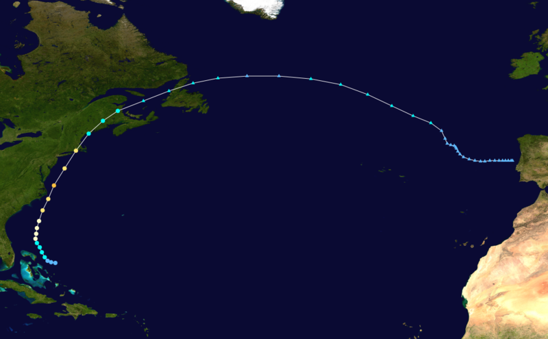
Figure 1. Track of Hurricane Bob, August 16-20, 1991.
IMPACTS ON EASTERN NORTH CAROLINA
Bob originated from the remnants of a frontal trough. Showers and thunderstorms increased along this frontal trough just south and southeast of Bermuda on August 12, 1991. The area of disturbed weather moved toward the southwest and west during the next few days. Surface analyses indicated that a weak (1015 mb) low had formed within the area of disturbed weather, a couple of hundred nautical miles to the east of Bahamas. However, animation of high resolution visible satellite imagery during that period revealed only a broad, poorly-defined cyclonic circulation of low clouds near a band of convection with little curvature.
The area of disturbed weather was more organized on satellite imagery the next day. In addition, a closed circulation at a flight level of 1500 feet, and a maximum wind of 37 mph were reported by the U.S. Air Force Reserve unit aboard the first reconnaissance flight into the system. Based on these data, it is estimated that the area of disturbed weather became the third tropical depression of the Atlantic hurricane season at on August 15, while centered 175 nautical miles east of Nassau in the Bahamas. Visible satellite pictures on the 16th showed further development, including a more-curved convective band wrapping around the west and south quadrants of a well-defined low-level cloud-system center that was moving west-northwest at about 6 miles.
Both the reconnaissance data on August 16, which included a 59 mile wind at the 1500-feet flight level and a surface pressure of 1005 mb, and satellite intensity estimates from the NESDIS Synoptic Analysis Branch supported upgrading the depression to Tropical Storm Bob at that time. Bob was then centered 120 nautical miles northeast of Nassau. The storm continued strengthening and began moving more toward the northwest under the influence of the deep layer mean flow.
On August 17, satellite imagery showed increased convective banding around a central dense overcast. An Air Force reconnaissance plane encountered 82 mph winds at the 1500-feet flight level, and a surface pressure of 987 mb was reported. The onboard Air reconnaissance Weather Officer estimated surface winds at 75 miles. Based on these reports, Bob was upgraded to a hurricane at 2 PM EDT on the 17th, while centered 205 nautical miles east of Daytona Beach, Florida. The hurricane began turning toward the north and then northeast at an increasing forward speed. The steering flow was the result of the combined effects of the subtropical high pressure ridge over the Atlantic and a mid to upper-level trough over the southeastern united States.
Deep convection became more concentrated near the center of the hurricane and a well-defined eye appeared in satellite pictures late on August 18. Bob continued intensifying and the eye became even more distinct as it passed 25 to 30 nautical miles east of Cape Hatteras early on the 19th. An Air Force reconnaissance plane August 19 encountered 137 mile winds at the 700 mb flight level and a surface pressure of 950 mb was measured. These reports are the basis for showing the maximum surface wind of 115 mph while Bob was located about 90 nautical miles east-southeast of Norfolk, Virginia. Bob was a Category 3 hurricane on the Saffir/Simpson Hurricane Scale at this time and was moving toward the north-northeast near 23 miles.
Bob continued to move toward the north-northeast, steered by the flow between a mid to upper-level cut-off low near the Great Lakes, and a strong Atlantic subtropical high pressure ridge. In this steering flow, Bob moved parrellel to the United States mid-Atlantic coast and headed toward New England on a track similar to the tracks of Hurricanes Carol and Edna 1954.
Bob weakened while accelerating the north-northeast over waters which became significantly cooler off of the mid-Atlantic coast. The eye was partially filled with clouds when it passed just east of Long Island, New York. The west side of a weakened eyewall passed over Montauk Point on the eastern tip of the island. The eye passed over Block Island and moved over Newport, Rhode Island. Aircraft reconnaissance personnel were unable to report an eye just prior to this landfall, because less than 50% of the center was surrounded by an eyewall. By the time of landfall on Rhode Island, Bob was moving toward the north-northeast at 32 miles with maximum sustained winds of a Category 2 hurricane.
Bob crossed Rhode Island and Massachusetts, with the center moving between Boston and Scituate. It then moved over Massachusetts Bay. The hurricane continued to weaken and began losing tropical characteristics as it passed just offhore of the southern coast of Maine and made landfall as a tropical storm near Rockland, Maine on August 20. Bob turned more toward the northeast and crossed Maine and New Brunswick. Bob exited New Brunswick near Chatham and became extratropical over the Gulf of St. Lawrence. It then crossed northern Newfoundland, and the central North Atlantic, before moving southeastward and dissipating near the coast of Portugal on August 29.
Shortly before Bob was upgraded to a hurricane on August 17, the National Hurricane Center issued a hurricane watch for coastal areas of North Carolina between Little River Inlet northward to Virginia Beach, Virginia. Roughly four hours after this watch, it was upgraded to a hurricane warning. Mandatory evacuation orders were declared for the Outer Banks. Local police assisted significant traffic as an estimated 50,000 to 100,000 people left the region. At the height of the evacuations, delays in some places exceeded three hours. Several bridges in the area were shut down prior to Bob's arrival as hurricane-force winds were likely to create life-threatening conditions on them. The National Park Service also shut down campgrounds across the Outer Banks. An evacuation shelter was also opened in Carteret County.
On August 18, 1991, Hurricane Bob brushed the Outer Banks of North Carolina, bringing strong winds and heavy rains. Although a maximum of 5.30 inches of rain fell at the National Weather Service office building at Buxton, little heavy rain fell inland of the Outer Banks. One person was killed in the state due to Bob, and damage from the storm was estimated at $8 million. The community of Duck, North Carolina, received the highest recorded onshore sustained winds in the state, 62 miles per hour, whereas the highest gusts reached 74 miles per hour at Cape Hatteras. Diamond Shoals Light recorded a sustained wind of 97.8 mph with a gust of 122.8 mph and a minimum pressure of 962.1 millibars on the evening of 18/19 August, 1991. Cape Hatteras also recorded a storm surge of 2.6 to 4.6 ft.
Flooding was reported throughout the Outer Banks in relation to the heavy rains and storm surge of the storm. The storm required the shutdown of North Carolina Highway 12, the only highway connecting the area to the mainland, isolating those who decided to stay behind. Many residents lost power as numerous power lines fell from strong winds. Six brief tornadoes, ranging between F0 and F1 on the Fujita scale, struck the state within squall lines in the outer rainbands of Hurricane Bob were recorded. Four tornadoes in Dare County caused $256,000 in damage. Near Cape Hatteras, wind severely damaged one structure, which lost its roof and some siding.

Hurricane Bob at its maximum intensity in the Mid Atlantic, August 19, 1991.
SOURCES
National Hurricane Center
Wikipedia


.png) Surf Forecast/Rip Currents
Surf Forecast/Rip Currents Map View
 Weather Hazard Briefing (when applicable)
 Forecaster Discussion
 Marine
 Text Products
.png) Skywarn
Skywarn Submit Storm Reports
 Coastal Flood
 Follow us on YouTube