Event Overview
Scattered thunderstorms during the late morning and early afternoon hours of August 12th produced wind damage and large hail in portions of eastern North Carolina. Wind gusts were estimated as high as 70 to 80 mph, and golf ball sized hail fell in the strongest thunderstorms. One building (Figure 1.), near Beautancus in northwest Duplin county, was completely destroyed by strong winds.
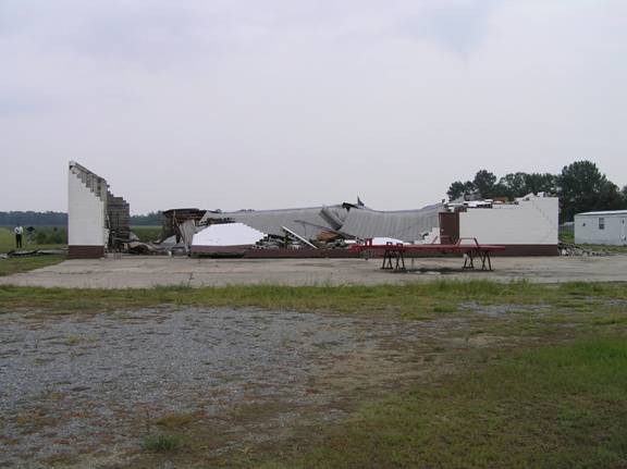
Figure 1. Welding shop near Beautancus destroyed.
Synoptic Overview
Surface analysis at the time of the thunderstorm outbreak (Figure 4.) showed an easterly wind flow over eastern North Carolina circulating around high pressure to the north. A trough extending northeast into the coastal plain from a low pressure center over eastern Georgia was evident. The low pressure trough helped focus severe thunderstorms that occurred during the early afternoon over Greene and Duplin counties. These storms produced mainly wind damage to trees and power lines, but also resulted in some structural damage in northwest Duplin County. A severe thunderstorm that developed near Jacksonville in Onslow County and produced quarter size hail, likely developed on outflow from a previous, nearly stationary thunderstorm in southwest Onslow County earlier that morning. This thunderstorm produced hail to the size of golfballs and significant crop damage as it moved to near Pollocksville in Jones County during the afternoon.
Thunderstorms were able to become develop and become severe due to the presence of several meteorological factors that came together during midday of August 12th. First and foremost was the presence of the right rear quadrant of an exiting 90 knot jet maximum (Figure 2.) over the area. This in turn produced strong upper level diffluence which allowed thunderstorms to grow and sustain strong updrafts. Secondly, was the occurrence of a low level (850 MB) dew point axis (Figure 3.) which maintained a moisture rich lower atmosphere.Third was the presence of low level boundaries, the aforementioned outflow and surface low pressure trough (Figure 4.) upon which storms were able to focus and gain strength. All of the above factors coming together at the right time resulted in severe thunderstorms over eastern North Carolina during the late morning and early afternoon of August 12th.
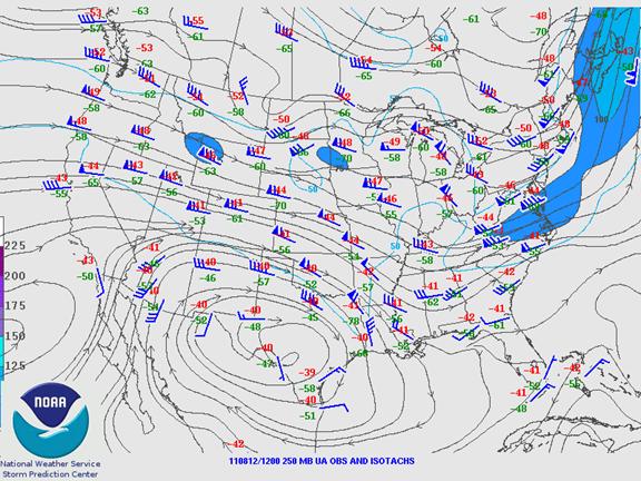
Figure 2. 250 MB Jet Analysis 8 am 12 Aug
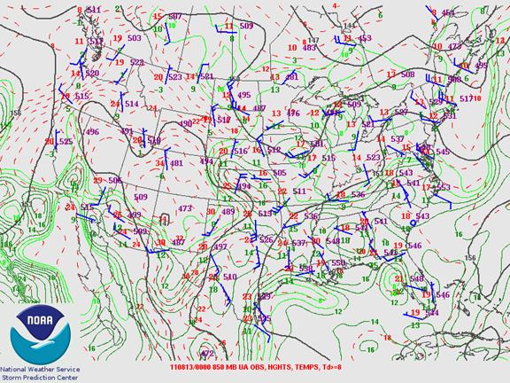
Figure 3. 850 MB Analysis 8 pm 12 Aug
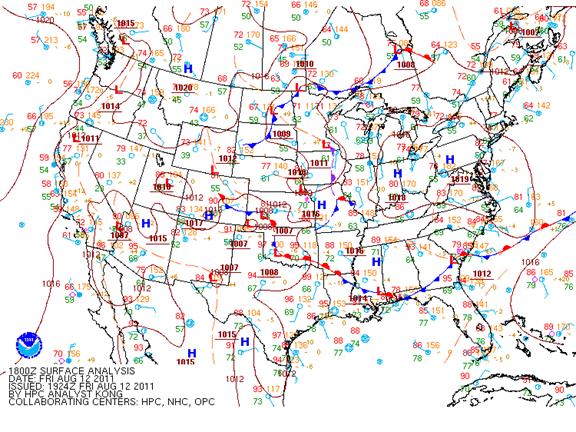
Figure 4. Surface Fronts and Pressures 2 pm 12 Aug
Radar Imagery -
Base Reflectivity (Figure 5.) from the severe thunderstorm that produced golfball size hail west of Pollocksville (video below). Note the very high reflectivity cores (70+ DBZ) in the area.

Figure 5. MHX WSR-88D 12/1619Z Base Reflectivity
Base Velocity (Figure 6.) from the severe thunderstorm that blew down the building northeast of Beautancus (picture above). Note the very high values (50+ knots) just west of the area where the building was destroyed.

Figure 6. MHX WSR-88D 12/1720Z Base Velocity
Case Study Team:
Brian Cullen
Hal Austin
Jeremy Schulz


.png) Surf Forecast/Rip Currents
Surf Forecast/Rip Currents Map View
 Weather Hazard Briefing (when applicable)
 Forecaster Discussion
 Marine
 Text Products
.png) Skywarn
Skywarn Submit Storm Reports
 Coastal Flood
 Follow us on YouTube