Event Overview
On 12 August 2009, flooding rains hit a small portion of northern Carteret and southern Craven Counties. The rains were associated with regenerative warm-topped convection along a stalled sea breeze boundary and a weak frontal boundary extending along portions of Onslow, Carteret, and Craven Counties. The convergence-locked convection over Havelock resulted in almost 10 inches of rain between noon and 4 pm. Rainfall rates were as high as 5.7 inches per hour according to measurements from the Cherry Point MCAS ASOS (see table 1). In the town of Havelock, the hardest hit area, roads were closed, water inundated into several homes and businesses, and local schools and the Cherry Point Marine Air Station locked down for several hours until the flood waters receded.
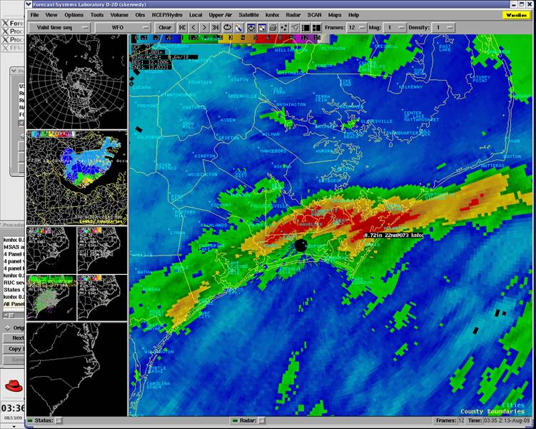
Figure 1: Morehead City (MHX) Doppler Radar storm total rainfall for August 12, 2009
Synoptic Overview
The rains were associated with an upper level trough over the Eastern U.S., digging south into the mid-Atlantic. A vorticity max on the back side of the trough moved slowly down and strengthened as it rounded the base of the trough mid morning of the 12th. Meanwhile, the right front entrance region of the upper level jet slid south out of the Ohio River Valley towards the mid-Atlantic by Wednesday morning. The position of these features put eastern North Carolina under the best support aloft.
At the surface, a weak frontal boundary lingered over the coastal plains. There was no notable change in pressure, though the gradient over the affected area strengthened slightly through the day on the 12th. The surface dewpoints were extremely moist, mainly in the mid-70's throughout the region. The precipitable water amounts were around 2.25 inches, particularly high for a non-tropical environment in mid August (see figure 2). This was the result of several days of a strong moisture feed off the Gulf of Mexico, evident by water vapor satellite imagery showing a plume of high water content over the southeast including eastern North Carolina. The 12Z
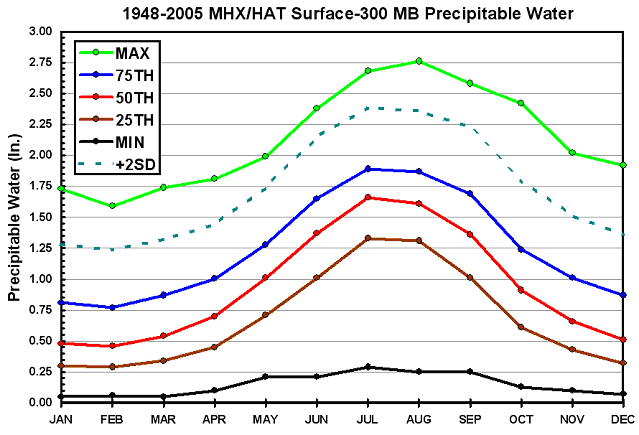
Figure 2: Climatology of perceptible water values based on MHX upper air soundings for August show that the 8/12/09 event was 2 standard deviations above normal with a value of 2.25”.
Scattered showers began developing throughout the morning, with little overall organization or coverage in any one area. The focus for thunderstorms became more defined as the front shifted south slightly, and stalled along the southern or Crystal Coast region by mid morning. The convection began to produced periods of heavy rainfall, but forecasters noted a high bias of 0.6-0.75 (assumes radar is overestimating) when monitoring earlier storms. As the seabreeze developed around noon, surface convergence can be noted along a line from Onslow to Carteret Counties, with light northwest winds over the majority of the area, and southwest over the Crystal Coast. The western edge of this line of convection shifted slightly, preventing training and significant flooding over Onslow or western Carteret Counties. The central and eastern end of the convection lingered over southern Craven and eastern Carteret Counties from around noon through 5 pm before sliding south and offshore.
Radar showed heavy rains developing along the seabreeze boundary, with localized rates as high as 3 inches per hour, and averaging 1 to 2 inches per hour elsewhere. A flood advisory was issued at 218 pm for Craven and Onslow Counties as radar event total quantitative precipitation estimates (QPE) of 2 to 4 inches were observed. The flood advisory was upgraded to a flood warning around 3 PM for both Craven and Onslow Counties as radar indicated rainfall amounts totaling 3 to 5 inches with excessive rainfall rates around 4 inches per hour. The warning included wording for event total rainfall amounts upwards of 8 inches. Another flood warning was issued at 349 pm for eastern Carteret County. Doppler radar indicated an event total rainfall for Havelock around 7 inches, though ASOS and other unofficial readings of 8 to 10 inches were reported (see figure 3).
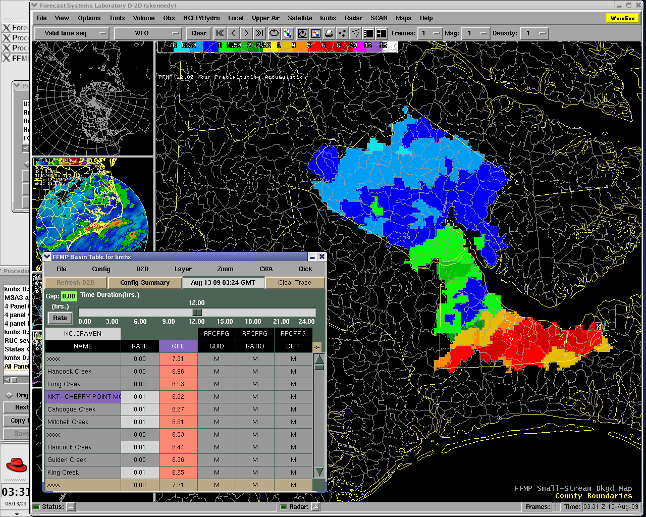
Figure 3: Flash Flood Monitoring and Prediction (FFMP) based primarily on radar data indicated storm total rainfall amounts around 7 inches over the Havelock area.
|
Table 1. |
|
|
|
|
|
NKT ASOS |
|
|
|
|
|
Cherry Point MCAS |
August 12 Precipitation Observations |
|||
|
Time Recorded (Z) |
Time Recorded ( |
Rainfall (inches) |
Rainfall Rates (inches per hour) |
|
|
1654 |
11:54 PM |
0.00 |
|
|
|
1709 |
12:09 PM |
0.18 |
0.72 |
|
|
1716 |
12:16 PM |
0.57 |
3.34 |
|
|
1723 |
12:23 PM |
1.09 |
4.45 |
|
|
1733 |
12:33 PM |
1.32 |
1.38 |
|
|
1740 |
12:40 PM |
1.44 |
1.02 |
|
|
1750 |
12:50 PM |
1.94 |
3.00 |
|
|
1754 (Hourly Total) |
12:54 PM |
2.21 |
2.21 |
|
|
1804 |
1:04 PM |
0.47 |
2.82 |
|
|
1830 |
1:30 PM |
2.02 |
3.58 |
|
|
1846 |
1:46 PM |
3.11 |
4.09 |
|
|
1854 (Hourly Total) |
1:54 PM |
3.49 |
3.49 |
|
|
1946 |
2:46 PM |
2.52 |
2.90 |
|
|
1954 (Hourly Total) |
2:54 PM |
2.93 |
2.93 |
|
|
1958 |
2:28 PM |
0.30 |
4.50 |
|
|
2003 |
3:03 PM |
0.68 |
5.70 |
|
|
2054 (Hourly Total) |
3:54 PM |
1.02 |
1.02 |
|
|
2101 |
4:01 PM |
0.00 |
0.00 |
|
|
2154 (Hourly Total) |
4:54 PM |
0.03 |
0.03 |
|
|
2254 (Hourly Total) |
5:54 PM |
0.02 |
0.02 |
|
|
|
|
|
|
|
|
Event Total Rainfall |
9.70” |
Event Average Rainfall Rate |
2.97” per hour |
|
|
Table 2 |
||
|
COCORAHS PRECIPITATION REPORTS |
||
|
Station Number |
Location |
Precipitation |
|
NC-CR-4 |
HARKERS ISLAND 4.8 NNE |
6.03 |
|
NC-CR-20 |
HARKERS ISLAND 3.2 NE |
4.57 |
|
NC-PM-2 |
ORIENTAL 2.1 WSW |
3.96 |
|
NC-CR-18 |
NEWPORT 2.0 WSW |
3.50 |
|
NC-CN-12 |
Havelock 2.7 S |
8.98 Notes: My home was an Island with water 3 inches from entering my front |
|
NC-CN-1 |
Havelock 3.1 NW |
5.11 Notes: Radio stations reported 10 inches somewhere in this town and with |
|
|
|
|
|
|
|
|
MHX started receiving calls around 3 pm of heavy rain and ponding of water on local roads in the Havelock area. Critical in warning decision during this event was the near real-time observations from the Cherry Point MCAS ASOS (NKT), which validated the anomalous rainfall rates and amounts indicated by the radar. The flood warning was extended through the evening hours, to account for the slow receding of the flood waters though the rain had ended around 5 pm. A survey of the impacts was conducted by the hydrology focal point along with local law enforcement on the 13th, and determined that the flooding was localized to the eastern portions of Havelock and the grounds of Cherry Point MCAS. What prevented this event from becoming a more significant flooding situation was the combination of dry antecedent conditions and a well channeled drainage system ending along the Slocum Creek. However, due to excessive rainfall rates and rainfall totals of almost 10 inches in less than 4 hours, minor flooding to businesses and some apartments did occur.
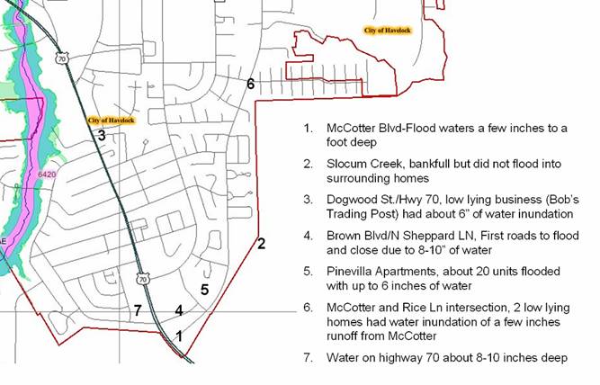
Figure 4: North Carolina State Floodplain Mapping inundation map for Havelock. Locations and extent of flooding listed.
|
Table 3. Event Flood Impacts |
Time |
Location |
|
CRAVEN COUNTY |
|
|
|
Water inundates from culverts into roads at end of ‘C’ St and 6th St. |
2-3 PM |
Cherry Point MCAS |
|
'C' Street was completely closed due to flooding toward the Roosevelt end that made it impassable. |
3-4 PM |
Cherry Point MCAS |
|
A parking lot off 6th Street (near the 'G' Street intersection) flooded so quickly that many cars were under water just sitting the parking lot. |
3-4 PM |
Cherry Point MCAS |
|
Brown BLVD Closed, minor flooding |
245 PM |
Havelock |
|
Water starting to flood Slocum Shopping Center |
245 PM |
Havelock |
|
Most of McCotter BLVD under water upwards of a foot, worse conditions at intersection with Tarheel Rd and Rice LN |
400 PM |
Havelock |
|
Shepard Street flooded, water up to the houses |
415 PM |
Havelock |
|
Pinevilla Apartments on Brown and McCotter flooded with as much as 6 inches of water |
430 PM |
Havelock |
|
8-10 inches of water on Highway 70 across from Hardees near McCotter and Shepard Rd |
400 PM |
Havelock |
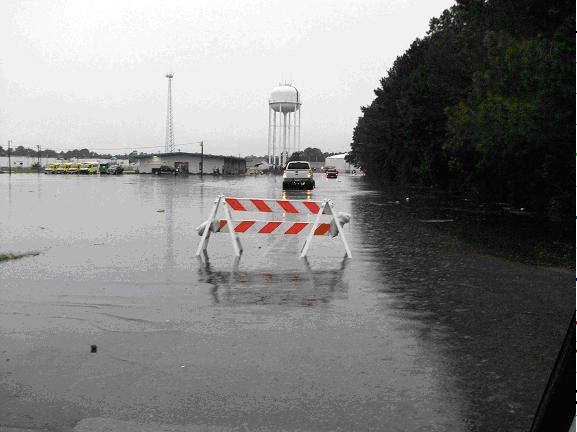
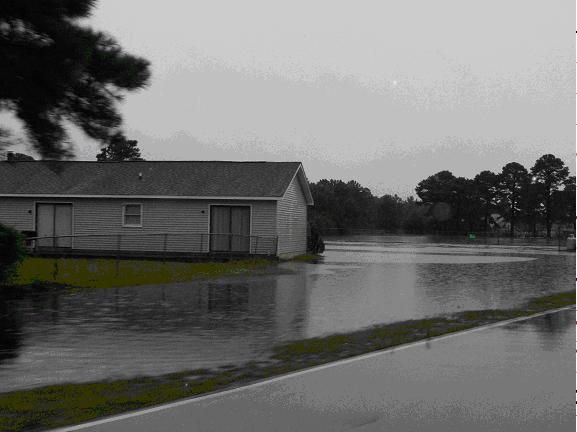
Damage Pictures from Havelock in Craven County
Photos courtesy of: Havelock Police Department


Case Study Team:
Sarah Jamison
Mark Willis
Brian Cullen
Bob Frederick
Scott Kennedy


.png) Surf Forecast/Rip Currents
Surf Forecast/Rip Currents Map View
 Weather Hazard Briefing (when applicable)
 Forecaster Discussion
 Marine
 Text Products
.png) Skywarn
Skywarn Submit Storm Reports
 Coastal Flood
 Follow us on YouTube