
Event Overview
On the afternoon of April 28, 2011, strong thunderstorms moved across Eastern North Carolina producing 3 confirmed tornadoes and reports of large hail (Figure 1). The tornadoes destroyed a hog farm, damaged numerous other structures, and knocked down numerous trees in Duplin County, produced downed trees and power lines near Vanceboro in Craven County, and produced minor damage at Plymouth in Washington County. These storms were part of a larger complex of severe weather that produced over 100 tornadoes and more than 300 deaths the previous day over Mississippi, Alabama, Tennessee and Georgia.
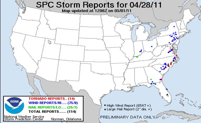
Figure 1. Severe Weather Reports from April 28, 2011
Synoptic Overview
A vigorous mid-level trough moved from the northern Plains April 27 to the Western Great Lakes by 12Z on April 28, 2011 (Figure 2). This advancing system was responsible for the worst tornado outbreak in the United States since 1974 with over 100 tornadoes and over 300 deaths reported on April 27. As result of the previous day’s tornado outbreak, awareness was high for tornadoes over the Region. As this system advanced eastward on the morningof April 28, deep moisture was advected north at 850 mb (Figure 3) with a 60 knot jet maximum poised just west of the area at 12Z. At the surface, a cold front pushed slowly across the state and was approaching from central North Carolina at 21Z (Figure 4), with very moist air over eastern North Carolina with dewpoint temperatures in the lower and middle 70s. Deep layer south to southwest wind shear and CAPE (Convective Available Potential Energy) values of 1000 to 2000 j/kg were enough to overcome the relatively weak mid level lapse rates. The 12Z Newport/Morehead City sounding (Figure 5) showed conditions favorable for tornadic development with 0 to 1 kilometer helicity values of 287 m2s2, and a right-turning hodograph indicative of strong low-level wind shear. Conditions also favored large hail with the wet bulb zero height around 9570 feet.
The initial tornado report was from Warsaw in southwestern Duplin County and came in shortly after 3 pm (19Z) with the MHX radar showing strong rotation at the lowest levels (Figure 6). This same supercell thunderstorm would continue to the northeast and produce another tornado touchdown near Fort Barnwell in Craven County (Figure 7). A supercell that formed to the east of this storm would later produce a tornado with minor damage over Plymouth in Washington County.
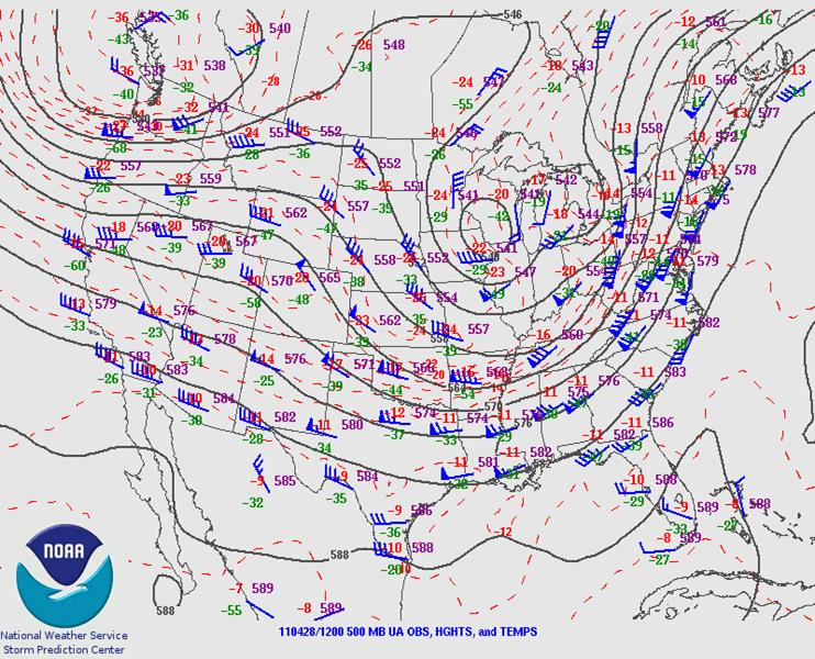
Figure 2. 500 mb Analysis at 12Z April 28 showing a broad mid-level trough advancing east.
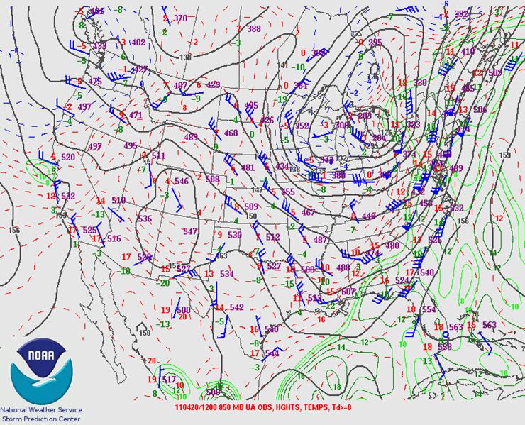
Figure 3. 850 mb Analysis at 12Z April 28 showing warm moist air being drawn northward into eastern North Carolina with a 60-knot jet maximum approaching from the west.
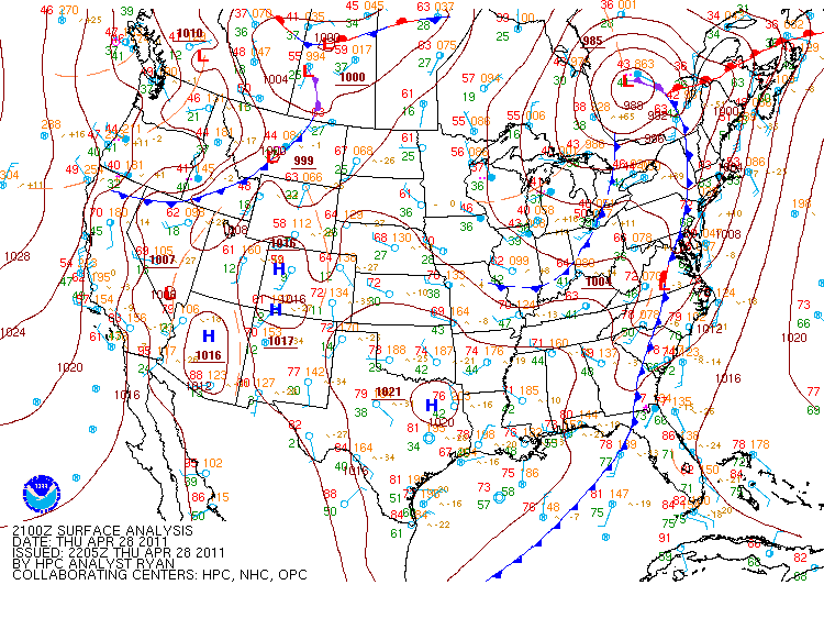
Figure 4. Surface Analysis at 21Z showing cold front approaching from the west. Dewpoints were in the 70s over Eastern North Carolina ahead of the front.
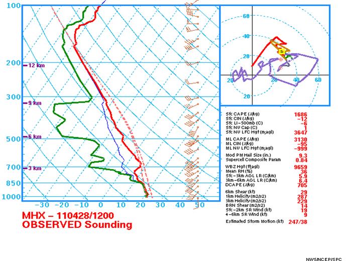
Figure 5. The 12Z Newport/Morehead City Sounding showed conditions favorable for tornadic and large hail development on April 28.
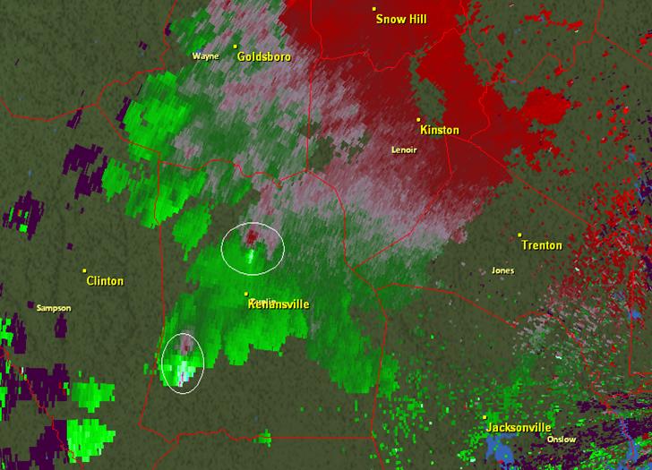
Figure 6. Newport/Morehead City Doppler radar indicated two areas of intense rotation over Duplin County shortly after 3 pm April 28. Warsaw in Western Duplin County, northwest of Kenansville reported the first tornado touchdown of the day.
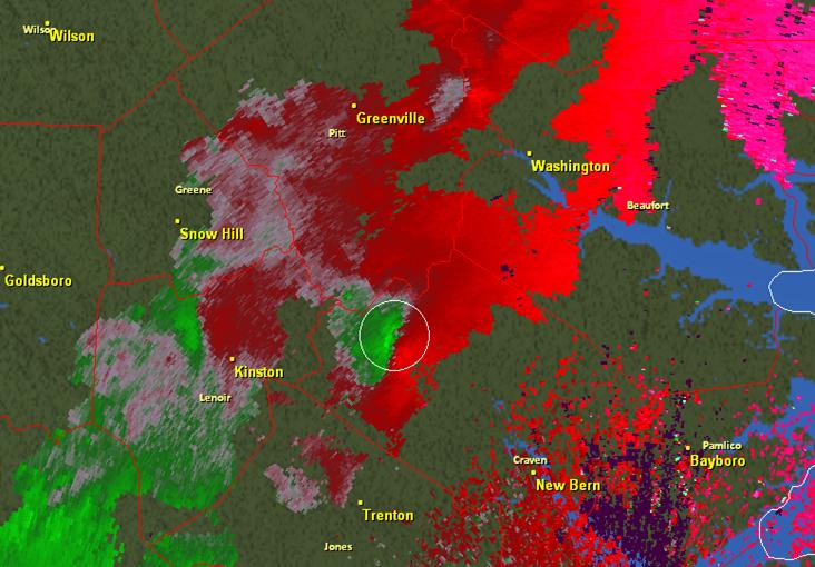
Figure 7. Newport/Morehead City Doppler radar indicated strong but broad rotation over northern Craven County around 430 pm April 28.
PRELIMINARY LOCAL STORM REPORT...SUMMARY
NATIONAL WEATHER SERVICE NEWPORT/MOREHEAD CITY NC
1211 PM EDT FRI APR 29 2011
..TIME... ...EVENT... ...CITY LOCATION... ...LAT.LON...
..DATE... ....MAG.... ..COUNTY LOCATION..ST.. ...SOURCE....
..REMARKS..
0252 PM TSTM WND DMG TEACHEY 34.77N 78.01W
04/28/2011 DUPLIN NC PUBLIC
SEVERAL TREES DOWN. TIME ESTIMATED BY RADAR.
0301 PM TSTM WND DMG 5 SE MAGNOLIA 34.84N 77.99W
04/28/2011 DUPLIN NC FIRE DEPT/RESCUE
TURKEY BARNS AND OUTBUILDINGS DAMAGED. TREES DOWN. NEAR
NC903 AND HALLS POND RD.
0310 PM TORNADO 8 SE WARSAW 34.92N 77.99W
04/28/2011 DUPLIN NC EMERGENCY MNGR
HOG FARM AND TREES SNAPPED IN A 150 TO 200 FT WIDE PATH
APPROX 0.5 MILES LONG.
0343 PM HAIL 1 N FARMVILLE 35.61N 77.59W
04/28/2011 E0.75 INCH PITT NC TRAINED SPOTTER
0345 PM HAIL 1 N PINK HILL 35.07N 77.74W
04/28/2011 E1.00 INCH LENOIR NC PUBLIC
0415 PM TSTM WND DMG 3 SE WILLIAMSTON 35.82N 77.02W
04/28/2011 MARTIN NC PUBLIC
TWO TREES DOWN ON A SHED ON BELLTOWN RD. TIME ESTIMATED
BASED ON RADAR.
0435 PM HAIL 3 NE VANCEBORO 35.34N 77.12W
04/28/2011 E2.75 INCH CRAVEN NC EMERGENCY MNGR
0435 PM TSTM WND DMG 1 E FORT BARNWELL 35.27N 77.31W
04/28/2011 CRAVEN NC EMERGENCY MNGR
TREES AND POWERLINES DOWN ON BELLTOWN ROAD.
0440 PM HAIL 1 SE WILMAR 35.39N 77.14W
04/28/2011 E1.00 INCH CRAVEN NC PUBLIC
RELAYED FROM 911 CENTER
0500 PM TORNADO PLYMOUTH 35.86N 76.75W
04/28/2011 WASHINGTON NC PUBLIC
TREE DOWN ON GARAGE. TIME ESTIMATED BY RADAR.
0500 PM TORNADO PLYMOUTH 35.86N 76.75W
04/28/2011 WASHINGTON NC PUBLIC
TREE DOWN ON PORCH ON MAIN ST.
0506 PM TSTM WND DMG PLYMOUTH 35.86N 76.75W
04/28/2011 WASHINGTON NC PUBLIC
POWERLINES DOWN ON CHERRY ST
0530 PM TSTM WND DMG WENONA 35.73N 76.63W
04/28/2011 WASHINGTON NC LAW ENFORCEMENT
TREES DOWN ON PIKE ROAD IN ADDITION TO 1 INCH HAIL
0620 PM FUNNEL CLOUD 3 SSW COLUMBIA 35.88N 76.27W
04/28/2011 TYRRELL NC LAW ENFORCEMENT
REPORTED OVER NEWLANDS ROAD HEADING NE TOWARD COLUMBIA.
RELAYED FROM 911 CENTER
&&
Sources –
Storm Prediction Center
GR2 Analyst Software


.png) Surf Forecast/Rip Currents
Surf Forecast/Rip Currents Map View
 Weather Hazard Briefing (when applicable)
 Forecaster Discussion
 Marine
 Text Products
.png) Skywarn
Skywarn Submit Storm Reports
 Coastal Flood
 Follow us on YouTube