Overview
A line of thunderstorms crossed parts of eastern North Carolina during the early morning hours of April 5th. One tornado occurred along with several reports of damaging winds.
Pre-Storm Conditions
Severe weather had been occurring over central North Carolina during the evening hours of April 4th…focused mainly on a warm front that was west of Raleigh. The Storm Prediction Center (SPC) had a tornado watch box out until 1 am for most of central North Carolina. As the initial batch of thunderstorms moved east of Raleigh, they began to weaken and no severe weather was anticipated as the latest analysis showed very limited instability. A second batch of showers and thunderstorms developed in northern South Carolina and south central North Carolina after 1 am and lifted east-northeast toward eastern North Carolina. This convection was associated with a weak impulse aloft with strong diffluence in the right rear of the upper jet. There was also an area of moisture convergence over the region ahead of a weak surface low over the central part of the state. The storms showed little organization as they lifted through far southeast North Carolina. SPC’s mesoanalysis webpage showed moderate low level shear with 0 -1km values around 30 kts. Although instability was meager, it was surface-based with observations showing temperatures inland around 70 with dew points in the mid 60s. Lifted Condensation Level (LCL) heights were fairly low around 750m. Low level shear was decreasing with the convection moving into a minimum in 0 to 1 km helicity.
Warning Event
As the thunderstorms approached Duplin County they became more organized with a decent line forming. Although beam angles were mainly above 4000 ft, regional radars began to show some enhanced base velocity signatures, and a severe thunderstorm warning was issued for parts of Cumberland and Sampson counties shortly after 230 am. As the short line of storms began to enter Duplin County, radar showed a strong reflectivity gradient on the leading edge with continued good inbound base velocities. Given these trends, a severe thunderstorm warning was issued for most of Duplin County at 318 am. At 335 am, the first report of damage was received when a tree was blown down near Albertson in Duplin County. Later on, the convective line of storms looked impressive across Lenoir County with strong inbound velocities of near 60 kts. The tornado occurred along the southern part of the line where weak and rather broad low level rotation was seen. The convective line turned into an impressive bow shape as it crossed northern Jones and parts of Craven County before it weakened. Reports of damage to trees and an outbuilding were received in Lenoir and Jones counties between 350 and 400 am. The last damage report was of a tree blown down near the Bayview ferry dock south of Bath at 450 am.
Damage Survey Report
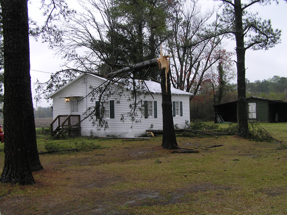
Damage associated with a weak EF1 tornado was assessed in southern Lenoir County with winds estimated at 90 mph. The tornado occurred just before 4 am and damage was approximately 10 miles south of Kinston between Highways 11 and 258 South. The initial damage occurred 2 miles east of Highway 11 on Jonestown Rd. Damage to two structures occurred there, most of a roof was blown off a home, a tobacco barn destroyed, and there was tree and power line damage. A couple of miles to the east-northeast along Nobles Mill Rd, additional damage occurred with an outbuilding moved off its block foundation and completely destroyed. Additional damage in this area included large pine trees snapped and a pine fell on a manufactured home. A mile or so east-northeast of that location, pine tree damage was encountered along 258 South just south of Nobles Mill Rd. The tornado seemed to skip along to the east-northeast for approximately 3 miles causing sporadic damage. The damage width was between 50 and 100 yds. There were no injuries or fatalities.
Damage Photos from Lenoir County
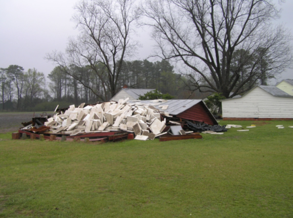
Out Building Destroyed on Nobles Mill Rd.
Tree Blown Down on Noble Mills Rd
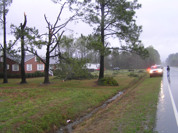
Downed Trees on Hwy 258 S
Case Study Team:
WFO MHX


.png) Surf Forecast/Rip Currents
Surf Forecast/Rip Currents Map View
 Weather Hazard Briefing (when applicable)
 Forecaster Discussion
 Marine
 Text Products
.png) Skywarn
Skywarn Submit Storm Reports
 Coastal Flood
 Follow us on YouTube