
Heavy to excessive rainfall is forecast for eastern Louisiana into central Alabama which could bring flash, urban, and riverine flooding Friday. Scattered severe thunderstorms with a few tornadoes, very large hail, and damaging winds are possible across parts of the Gulf Coast States Friday and Friday night. Read More >
Terry Huber and John Pendergrast
Introduction
Over the years, National Weather Service (NWS) and Department of Defense (DOD) meteorologists have issued many tornado warnings. The decision to issue a tornado warning can often be difficult. Until recently, analyzing reflectivity-based data was the primary tool available to radar operators to assist them during this most challenging situation. Prior to the introduction of the WSR-88D, radar operators relied on their ability to identify "characteristic signatures" in the reflectivity data as indicators of an imminent or occurring tornado. With the nationwide deployment of the WSR-88D, radar operators are no longer restricted to reflectivity data; rather, they now have velocity-based data to analyze as well.
Four cases will be presented where WSR-88D data were used to examine mesocyclone rotational velocity (VR) trends in supercells which produced tornadoes. Based on these case studies, a simple tool will be introduced for tracking VR trends. If used, this simple tool could aid NWS and DOD meteorologists during the tornado-warning decision process.
History
Considerable research has been conducted on the relationship between mesocyclones and tornado development. A complete treatment of this topic is beyond the scope of this paper; however, a brief summary of some relevant work on tornado generation is presented.
With the fine-scale analyses of portable Doppler radar and the ability to conduct post-event analysis using archived WSR-88D data, recent studies have shown mixed results concerning the nature of tornado development. Trapp and Mitchell (1995) found only 50 percent of mesocyclone tornadogenesis in 16 selected southern US tornadoes resulted from a descending mesocyclone core. The other 50 percent formed uniformly over several kilometers of vertical depth, or only appeared at the lowest levels. Brandes (1993) showed that mesocyclone intensification at the lowest levels could be a factor in tornado development. Local environmental conditions (i.e. shear/helicity or mesoscale wind and moisture fields) dictate to a large degree conditions that enhance tornado-development processes. Some pre-storm environments may not necessarily favor tornado development initially; however, storm-scale contribution from local parameters such as storm-relative inflow can drastically change the storm environment to become more favorable for tornado formation (Morgan 1997).
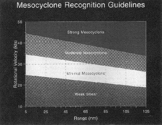
Historically, VR has been used to define mesocyclone core strength (Keighton et al. 1995). Although the WSR-88D has the capability of calculating and displaying numerical shear values at the Principal User Processor (PUP), shear values were not used for this study as shear can fluctuate artificially from volume scan to volume scan (Keighton et. al. 1995).
Data and Methodology
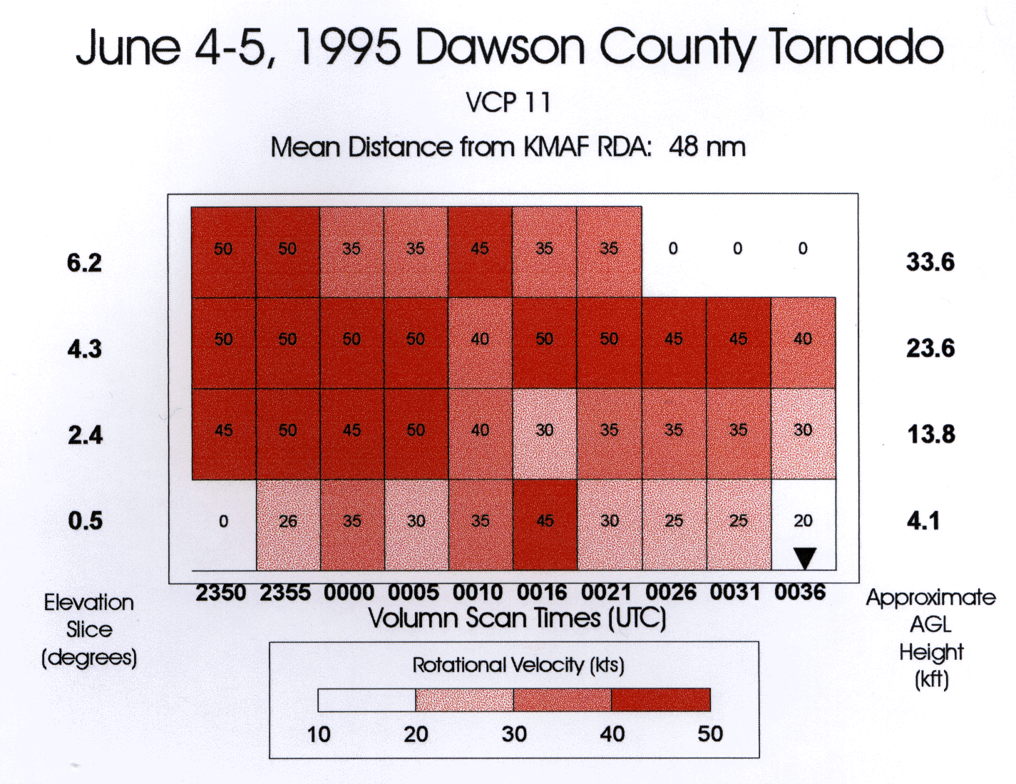
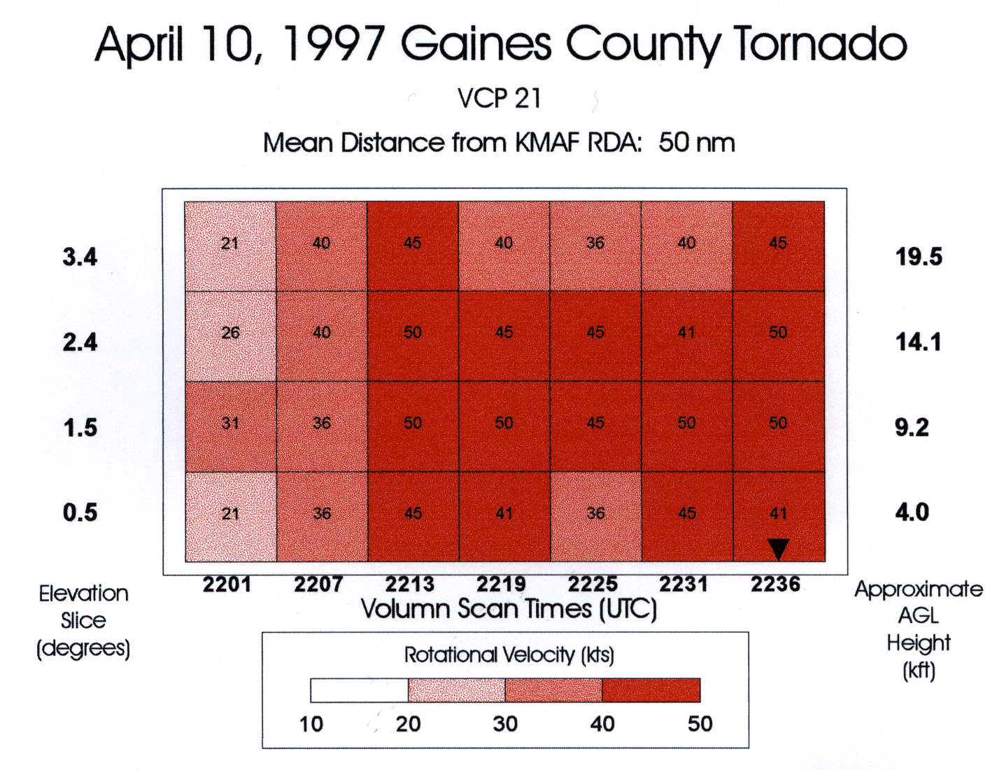
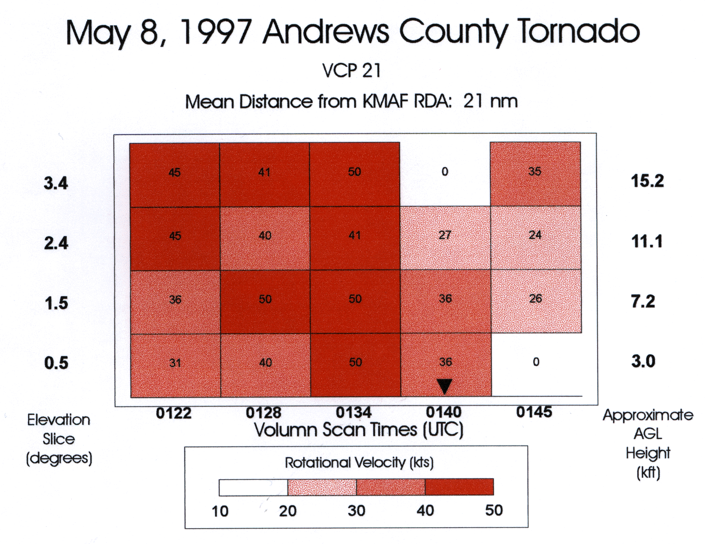
Four tornado events, which occurred in the NWSO Midland/Odessa County Warning Area between June 1995 and May 1997, were selected for this study. Post-event analyses of KMAF WSR-88D Archive IV data were performed using Storm Relative Mean Radial Velocity Map (SRM) products. In each case, a time series of mesocyclone couplets were identified. Based on the mean distance of each couplet from the KMAF Radar Data Acquisition site, it was determined that the four lowest elevation slices of the SRM products were most appropriate for examination. The VR/shear calculation function, introduced with PUP software build 8.0, was used to calculate the VR for each couplet. Wilken (1997) has shown in a recent study that VR values of 40 to 45 knots are good indicators of tornado formation. In each of the four cases used in this study, a persistent mesocyclone preceded a ground-verified tornado. Additional studies will need to be conducted for tornadogenesis under different conditions (i.e. bow echo, squall line, landspout, etc).
Following the calculation of VR for each couplet on each of the four elevations, spectral charts were created to show vertical and temporal trends of VR (Figs. 1, 2, 3, and 4). Spectral legends, included below each chart, were constructed with four intervals corresponding closely to the four intervals on the Mesocyclone Recognition Guidelines nomogram (Fig. 5). The legend intervals correspond roughly to the weak shear, minimal mesocyclone, moderate mesocyclone, and the strong mesocyclone areas of Figure 5.
Referring to Figures 1, 2, 3, and 4 each case shows a general downward trend of a VR maxima from higher to lower levels. In each of the four cases, the time of lowest descent of the VR maximum occurred prior to tornado touchdown. A small inverted triangle can be seen over the volume scan time closest to the tornado touchdown time. Considering the downward trend of VR maximum, a Tornado Warning issued for a VR value equal to or greater than 40 knots at the lowest elevation slice in each figure would produce lead times ranging from four minutes for Figure 4 to over 20 minutes for Figure 2. Although three of the four cases occurred within the 55nm threshold of the WSR-88D Tornado Vortex Signature (TVS) Algorithm range envelope, only the Dawson county tornado (Fig. 1) produced a TVS alarm.
 |
 |
 |
 |
 |
Summary
It is crucial for NWS and DOD meteorologists to track VR trends of mesocyclones. These four cases clearly demonstrate how spatial and temporal trends in VR maxima could be followed in real time, in an operational setting, to enhance the warning-decision process. The attached VR trends tracking log (Fig. 6) represents a simple tool which could be used by meteorologists when tracking VR trends of mesocyclones.
This log may be especially helpful when simultaneous VR trends of several mesocyclones are tracked, as monitoring VR trends of a single mesocyclone can be an extremely challenging task. When combined with the capability of the PUP to quickly calculate and display VR values, the log could aid meteorologists during the warning-decision process to produce increased lead times during tornado events, especially in classic-supercell storms.
Acknowledgments
The Authors would like to thank Brian Francis, SOO, NWSO Midland/Odessa and Loren Phillips, SOO, NWSFO Lubbock for input and review of this paper.
References
Brandes, Edward A., 1993: Tornadic Thunderstorm Characteristics Determined with Doppler Radar. The Tornado: Its Structure, Dynamics, Prediction and Hazards, Washington, DC, Amer. Geophysical Union, 143-159.
Keighton, Steve and Medlin, Jeff, 1995: The WSR-88D Operators Guide to Mesocyclone Recognition and Diagnosis, Operational Support Facility, Norman, OK, 17-19.
Morgan, Carl R., 1997: Effects of Storm Motion on a high CAPE-Low Shear Environment During the Central Texas Tornado Outbreak of May 27, 1997, Technical Attachment Southern Topics, National Weather Service Southern Region Hqts.
Trapp, Jeffery and Mitchell, E. Dewayne, 1995: Characteristics of Tornado Vortex Signatures Detected by WSR-88-D Radars, NOAA/ERL/National Severe Storms Laboratory.
Wilken, George R., 1997: Using WSR-88D Shear Products During Severe Storm Events, Technical Attachment Southern Topics, National Weather Service Southern Region Hqts.

