.jpg)
The arrival of a cold front combined with a very moist atmosphere combined to produce widespread shower and thunderstorm activity across the West Texas South Plains Tuesday afternoon and evening. The strongest storms were located across the far southern Texas Panhandle, where they produced severe wind gusts and torrential rain. The town of Tulia in Swisher County was hit particularly hard with up to four inches of rain and wind gusts in the 60s. Those storms produced an outflow boundary which moved south and picked up some blowing dust. Additional storms developed along the outflow and also produced pockets of heavy rain and severe wind gusts, especially across eastern Hockley and western Lubbock Counties.
The satellite image below shows the height of the activity around 6 pm Monday evening.

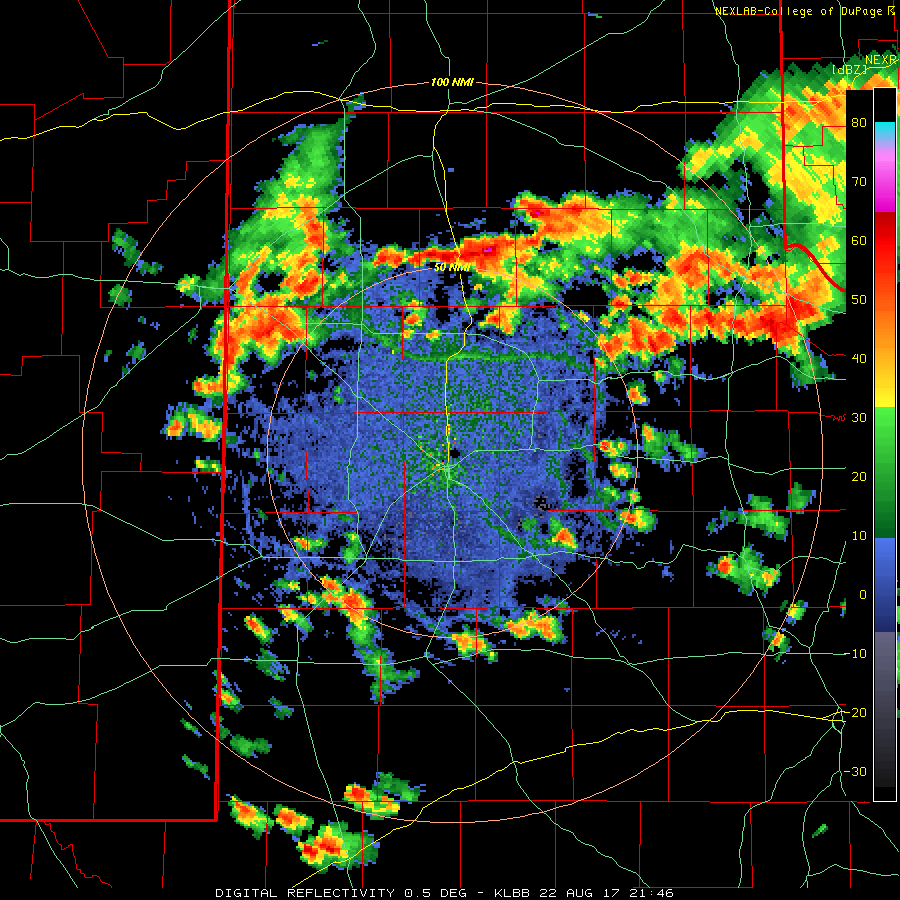
The radar loop below shows how the storms developed late Tuesday. The outflow boundary and additional storm development can be tracked by the radar.
Here is a map of the estimated 24-hour rainfall across the area. pockets of heavy rain were scattered across the whole region:
 |
|
|
24-hour rainfall analysis from 7 am CDT Monday, the 22nd to 7 am CDT Tuesday, the 23rd. Rainfall is calculated from radar estimates and gauge reports. Click on the image to enlarge it.
|
After the storms exited the Lubbock area in the evening, a brilliant rainbow developed:
.jpg) |
|
|
Looking east from Lubbock at a double-rainbow behind the exiting storms. Click on the image to enlarge it.
|
Another view of the rainbow below:
 |
|
|
Another photograph of the rainbow over Lubbock. Click on the image to enlarge it.
|
Here are the preliminary storm reports from the event:
LSRLUB

PRELIMINARY LOCAL STORM REPORT...SUMMARY
NATIONAL WEATHER SERVICE LUBBOCK TX
1046 PM CDT TUE AUG 22 2017

..TIME...   ...EVENT...      ...CITY LOCATION...     ...LAT.LON...
..DATE...   ....MAG....      ..COUNTY LOCATION..ST.. ...SOURCE....
            ..REMARKS..

0505 PM     TSTM WND GST     2 ENE TULIA             34.54N 101.74W
08/22/2017  M63 MPH          SWISHER            TX   MESONET

            REPORTED BY THE TEXAS TECH WEST TEXAS MESONET.

0515 PM     FLASH FLOOD      TULIA                   34.54N 101.77W
08/22/2017                   SWISHER            TX   POLICE DEPT

            UNDERPASS AT JUNCTION OF US 87 AND SH 86 CLOSED.
            TRAFFIC BEING DIVERTED IN PARTS OF TOWN. MANY YARDS
            FLOODED WITH RUNOFF INTO STREETS.

0700 PM     TSTM WND DMG     LUBBOCK                 33.58N 101.88W
08/22/2017                   LUBBOCK            TX   PUBLIC

            DAMAGE TO OUTDOOR CANOPY. TIME ESTIMATED.

0714 PM     FLASH FLOOD      6 SE LEVELLAND          33.52N 102.29W
08/22/2017                   HOCKLEY            TX   LAW ENFORCEMENT

            WATER AND MUD FLOWING OVER PORTIONS OF FM ROAD 1585
            WEST OF CR 168. FM 3261 CLOSED DUE TO HIGH WATER.

0728 PM     TSTM WND GST     3 NNE TAHOKA            33.21N 101.78W
08/22/2017  M62 MPH          LYNN               TX   MESONET

            ALSO MEASURED GUSTS TO 58 AND 59 MPH AT 727 PM AND 734
            RESPECTIVELY.

