Overview
During the early afternoon of March 31st, 2023, a strong low pressure system entered the Mid-Mississippi Valley. Within the warm sector of that system ahead of a dry line and strong cold front, discrete supercells formed during the late morning across western Missouri and tracked east into the National Weather Service St. Louis County Warning Area. In the presence of abundant instability and strong mid-level lapse rates, large (and in some cases, destructive) hail formed in several of these thunderstorms during the early and mid-afternoon. Hail varying in size from 1.00" to 3.50" was observed from Columbia, Missouri to Brown County, Illinois.
A second wave of severe thunderstorms tracked northeast from southwest Missouri and northern Arkansas, featuring large hail and the potential for tornadoes, given the impressive low-level shear. Despite this, no tornadoes were reported in Missouri during this event. As the cold front crossed the region during the evening of March 31st, the storms directly ahead of it grew upscale into a linear structure. By the time it reached St. Louis and southwest Illinois, it was producing severe wind gusts that uprooted/snapped trees in St. Louis and damaged a few structures in Illinois. Later that evening ahead of this line, the discrete thunderstorms became surface-based as they crossed into Illinois. One supercell produced a tornado in Marion County, IL that caused EF-1 damage in Salem, IL.
Below is a summary of this event, with pictures of damage. Credit to Iowa Environmental Mesonet for the accompanying GIF of radar reflectivity and warnings.
Tornado
|
Tornado - Salem, IL
|
||||||||||||||||
|
||||||||||||||||
The Enhanced Fujita (EF) Scale classifies tornadoes into the following categories:
| EF0 Weak 65-85 mph |
EF1 Moderate 86-110 mph |
EF2 Significant 111-135 mph |
EF3 Severe 136-165 mph |
EF4 Extreme 166-200 mph |
EF5 Catastrophic 200+ mph |
 |
|||||
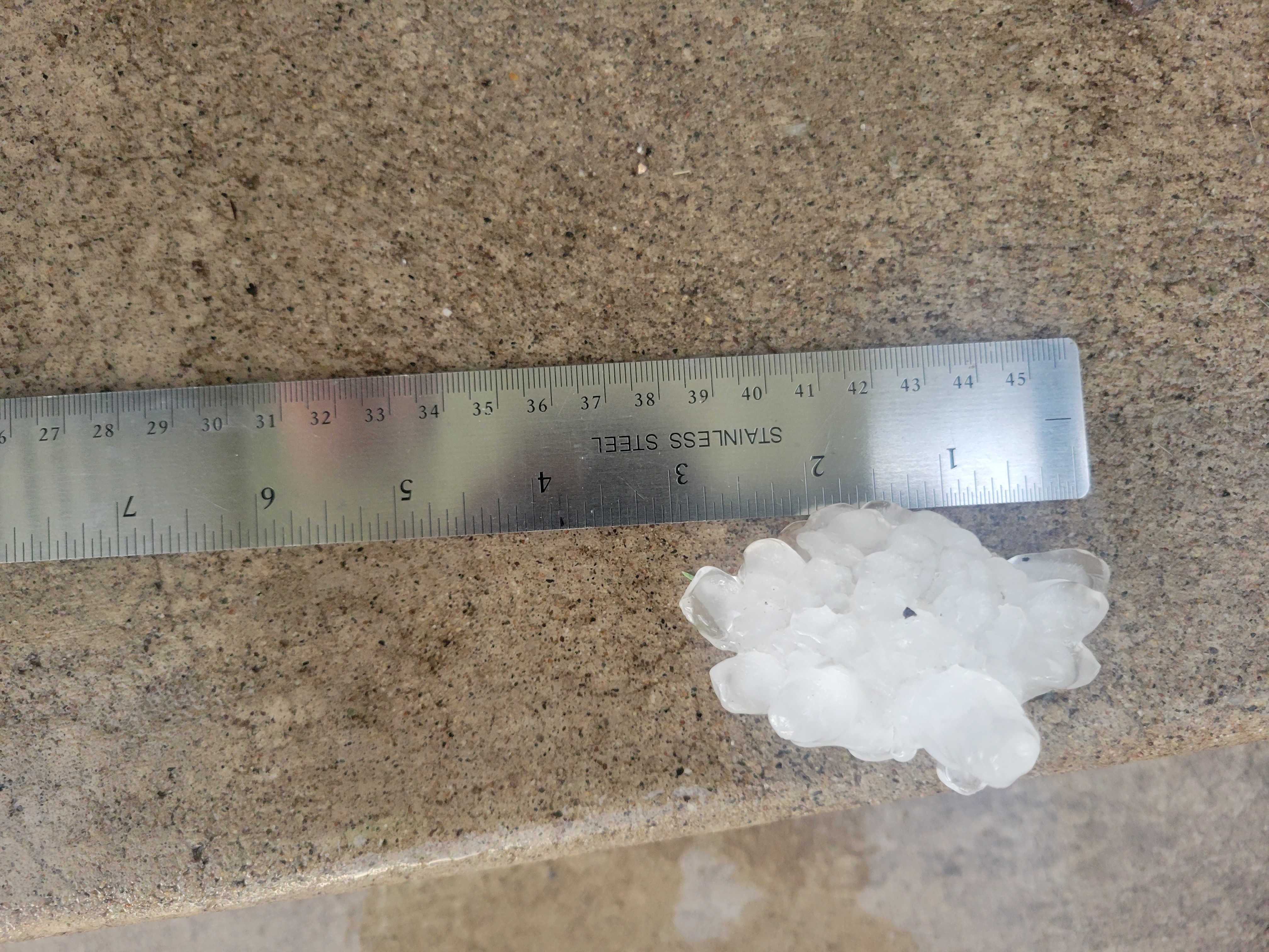
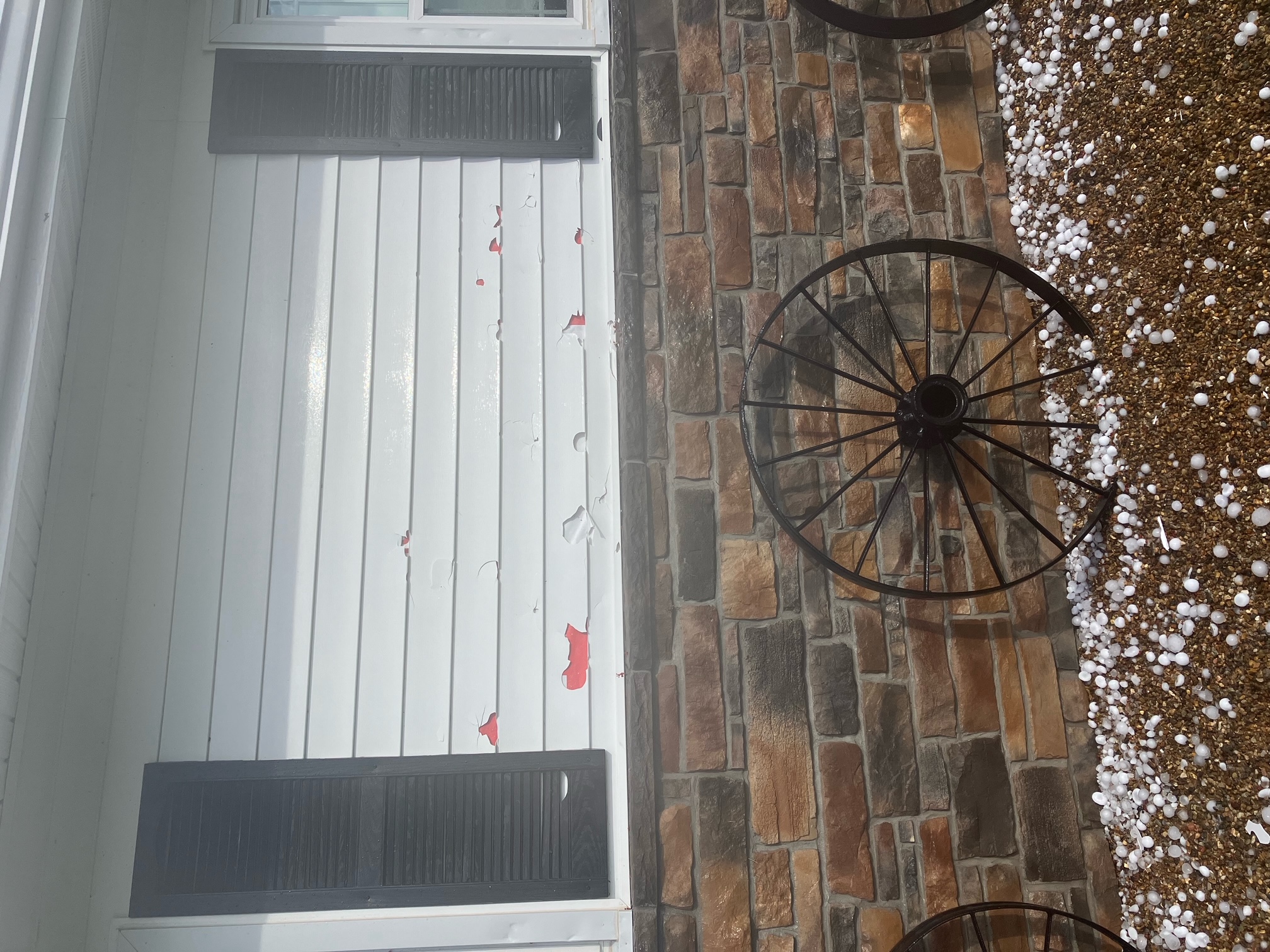
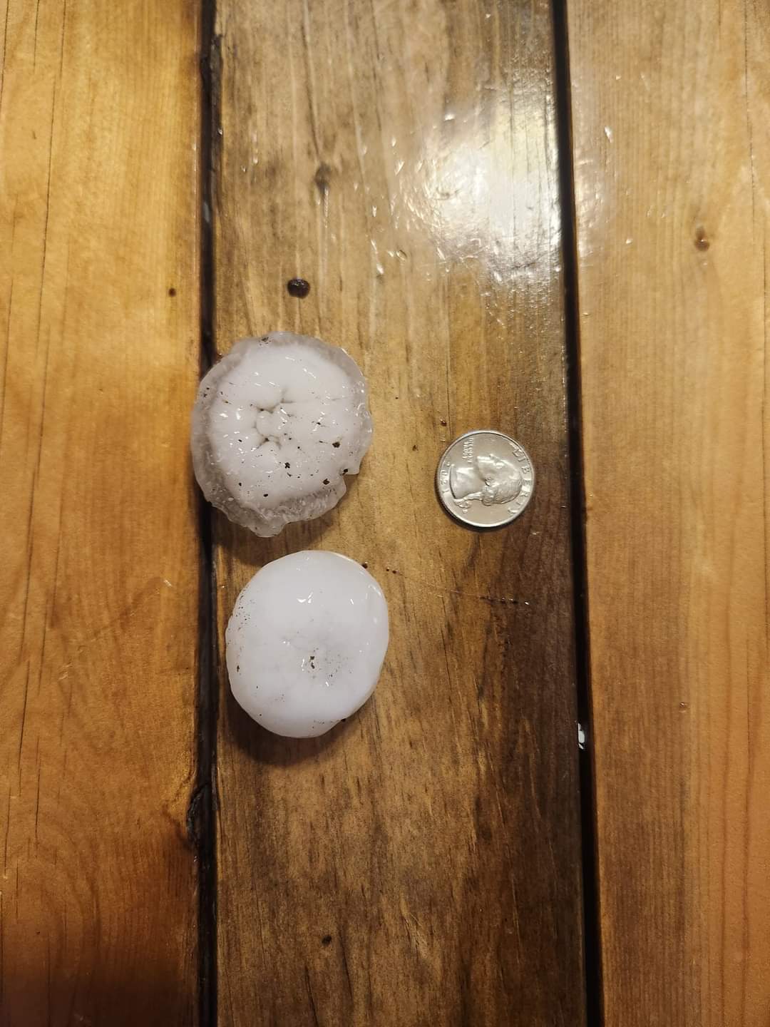
Large Hail and Wind Damage Pictures
 |
 |
 |
.jpg) |
| Hailstone measured to be 3 inches in diameter from Liberty, IL. (Bill Lantz) | Damage to the side of a house due to large hail in Laddonia, MO. (Brian and Susan Erdel) | Large hail measured to be approximately 2 inches in diameter from Laddonia, MO. (Chris Newbrough) | Hail measured to be 1.50 inches in diameter from O'Fallon, IL. (Bob Lilianstrom) |
 |
 |
 |
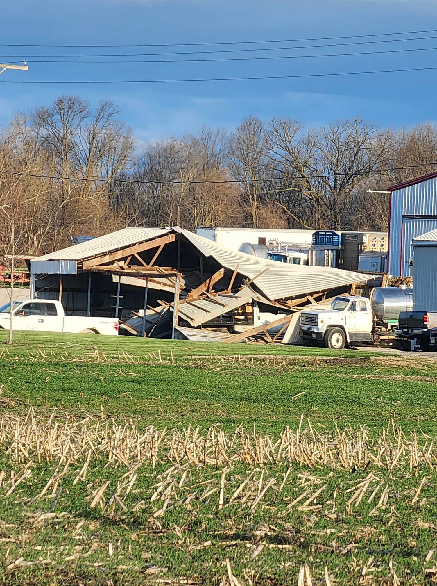 |
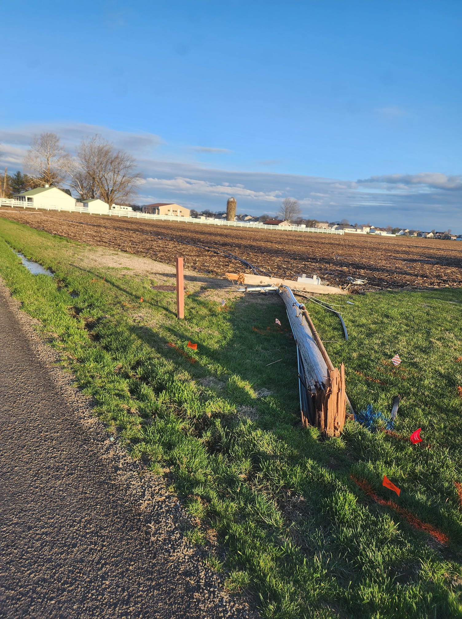
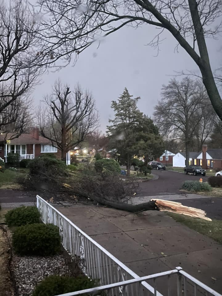
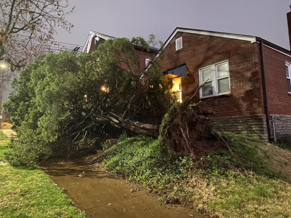
| A power pole snapped at the base by straight-line winds on Roosevelt Dr. in Bethalto, IL. (Tim Bertels) | A large tree snapped near the base, falling on several cars in the Tower Grove East neighborhood of St. Louis. (Abbey Wharton) | A large branch of a tree snapped on Watson Rd. in Shrewsbury, MO. (Morgan Halstead) | An outbuilding heavily damaged by straight-line winds on Fields Dr. in Moro, IL. (Tim Bertels) |
 |
 |
 |
 |
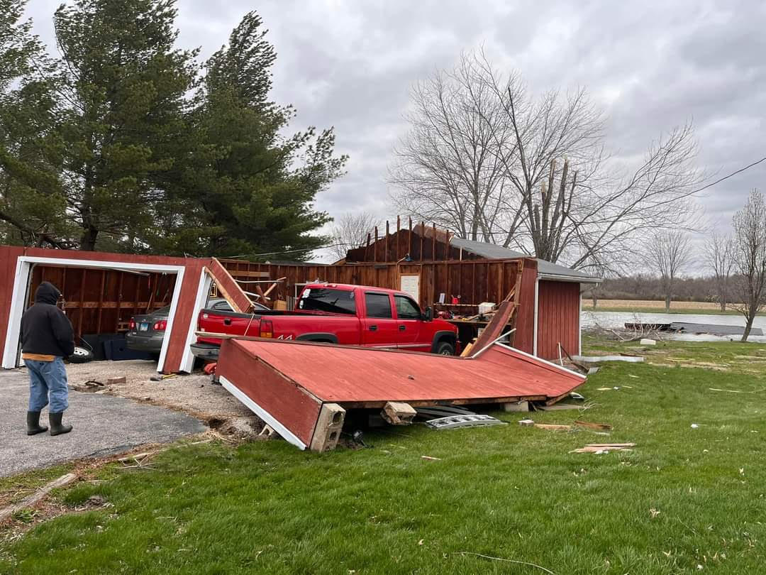
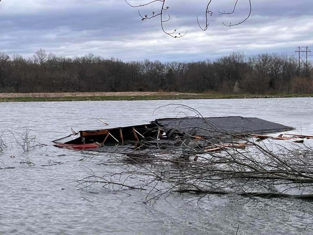
| A garage was damaged by straight-line winds in Prairietown, IL. (Amy Roe) | The roof of a garage was torn off and thrown into a nearby body of water by straight-line winds in Prairietown, IL. (Amy Roe) | A tree was uprooted by straight-line winds in the Tower Grove South neighborhood of St. Louis, MO. (Sarita Elliott) | A machine shed was damaged by straight-line winds in Dorsey, IL. (Lavada Belchik) |
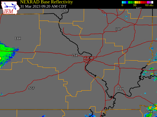
Radar
|
Northeast Missouri/West-Central Illinois Large Hail |
|
|
|
|
| A 4-panel image of radar data from KLSX as a severe thunderstorm crosses through southern Brown County, IL at 4:24 pm. Clockwise from the top left: 0.5° Reflectivity, 0.5° Storm-Relative Velocity, 0.5° Correlation Coefficient (CC), and 0.5° Base Velocity. Note the very high reflectivity values (pink) collocated with lower CC values, a few factors in determining large hail existed in this thunderstorm. | A 4-panel image of radar data from KLSX as a severe thunderstorm crosses through southern Brown County, IL at 4:24 pm. Clockwise from the top left: 4.0° Reflectivity, 4.0° Storm-Relative Velocity, 4.0° Correlation Coefficient, and 4.0° Base Velocity. Looking higher in the storm can give us a sense of the depth of the hail core, and how large the hail may be. These data show a hail core up to roughly 30,000ft (evident by the high reflectivity and near-zero differential reflectivity, which isn't shown). There is also a "three-body scatter spike" evident in the CC data (see the blue lines extending north from the storm), which can be an indicator of large hail. |
|
Salem, IL Tornado
|
| A 4-panel image of radar data from KVWX as a tornado crossed U.S. Route 50 in Salem, IL at 8:18 pm. Clockwise from the top left: 0.5° Reflectivity, 0.5° Storm-Relative Velocity, 0.5° Correlation Coefficient (CC), and 0.5° Base Velocity. Note the tornadic debris signature (TDS) where lower CC values are coincident with high reflectivity and rotation in the thunderstorm. |
Storm Reports
1225 PM HAIL 3 NW GRANVILLE 39.60N 92.13W
03/31/2023 M0.50 INCH MONROE MO TRAINED SPOTTER
1245 PM HAIL 3 ENE SPAULDING 39.63N 91.46W
03/31/2023 E1.25 INCH RALLS MO PUBLIC
DELAYED REPORT.
1248 PM HAIL 4 ENE SPAULDING 39.63N 91.46W
03/31/2023 E1.25 INCH RALLS MO PUBLIC
1250 PM HAIL 4 NNW NEW LONDON 39.64N 91.44W
03/31/2023 E1.00 INCH RALLS MO PUBLIC
REPORT FROM MPING: QUARTER (1.00 IN.).
1250 PM HAIL 1 S HANNIBAL 39.69N 91.38W
03/31/2023 E1.75 INCH MARION MO PUBLIC
1254 PM HAIL 1 N HANNIBAL 39.73N 91.38W
03/31/2023 U1.00 INCH MARION MO PUBLIC
REPORT FROM MPING: QUARTER (1.00 IN.).
1255 PM HAIL 1 NW HANNIBAL 39.72N 91.39W
03/31/2023 M0.80 INCH MARION MO TRAINED SPOTTER
1255 PM HAIL 1 N HANNIBAL 39.72N 91.38W
03/31/2023 M1.00 INCH MARION MO TRAINED SPOTTER
1256 PM HAIL HANNIBAL 39.71N 91.38W
03/31/2023 M1.75 INCH MARION MO LAW ENFORCEMENT
LAW ENFORCEMENT RELAYED REPORTS OF HAIL
RANGING FROM PEA TO GOLF BALL SIZE.
1259 PM HAIL 1 E HANNIBAL 39.71N 91.36W
03/31/2023 M1.00 INCH MARION MO BROADCAST MEDIA
PUBLIC REPORT RELAYED BY MEDIA.
0100 PM HAIL HANNIBAL 39.70N 91.39W
03/31/2023 M1.00 INCH MARION MO TRAINED SPOTTER
0100 PM HAIL 1 SW HANNIBAL 39.70N 91.39W
03/31/2023 E1.00 INCH MARION MO PUBLIC
0100 PM HAIL 1 ESE PAYSON 39.81N 91.22W
03/31/2023 E0.25 INCH ADAMS IL PUBLIC
0110 PM HAIL 2 N RICHFIELD 39.84N 91.11W
03/31/2023 E0.25 INCH ADAMS IL PUBLIC
0130 PM HAIL 2 NE QUINCY 39.95N 91.37W
03/31/2023 M1.00 INCH ADAMS IL TRAINED SPOTTER
TIME ESTIMATED BY RADAR.
0130 PM HAIL 1 NE QUINCY 39.94N 91.38W
03/31/2023 E1.00 INCH ADAMS IL BROADCAST MEDIA
PUBLIC REPORT RELAYED BY BROADCAST MEDIA.
0131 PM HAIL 5 SSE URSA 40.01N 91.35W
03/31/2023 U1.00 INCH ADAMS IL PUBLIC
REPORT FROM MPING: QUARTER (1.00 IN.) TIME
ESTIMATED FROM RADAR.
0211 PM HAIL 2 NE LIBERTY 39.90N 91.08W
03/31/2023 U1.00 INCH ADAMS IL EMERGENCY MNGR
REPORT OF DAMAGED SIDING AND WINDOW FRAMES
DUE TO HAIL. HAIL SIZE IS UNKNOWN AT THE
LOCATION. SURROUNDING REPORTS WERE AROUND
ONE INCH.
0310 PM HAIL 5 NNW STURGEON 39.30N 92.30W
03/31/2023 E1.50 INCH AUDRAIN MO EMERGENCY MNGR
REPORT RELAYED BY EMERGENCY MANAGEMENT. TIME
ESTIMATED BY RADAR.
0320 PM HAIL 6 S MADISON 39.39N 92.21W
03/31/2023 E1.00 INCH MONROE MO PUBLIC
DELAYED REPORT.
0326 PM HAIL 4 S STOUTSVILLE 39.50N 91.86W
03/31/2023 M0.70 INCH MONROE MO TRAINED SPOTTER
0333 PM HAIL MCBAINE 38.89N 92.45W
03/31/2023 M1.75 INCH BOONE MO EMERGENCY MNGR
0333 PM HAIL 4 W FLORIDA 39.49N 91.87W
03/31/2023 M1.75 INCH MONROE MO TRAINED SPOTTER
TRAINED SPOTTER CALLED TO REPORT GOLF BALL
SIZE HAIL WAS FALLING. HAIL IS RESULTING IN
BROKEN WINDOWS AT THE RESIDENCE.
0333 PM HAIL 4 S COLUMBIA 38.90N 92.34W
03/31/2023 M0.88 INCH BOONE MO EMERGENCY MNGR
NICKEL SIZE HAIL REPORTED OFF S. COMMERCIAL
DRIVE.
0335 PM HAIL 4 S COLUMBIA 38.90N 92.34W
03/31/2023 M1.75 INCH BOONE MO EMERGENCY MNGR
0335 PM HAIL 3 SSE COLUMBIA 38.91N 92.31W
03/31/2023 M2.00 INCH BOONE MO PUBLIC
0335 PM HAIL 3 S COLUMBIA 38.92N 92.33W
03/31/2023 E1.25 INCH BOONE MO PUBLIC
DELAYED REPORT.
0336 PM HAIL 2 SE COLUMBIA 38.93N 92.30W
03/31/2023 M1.00 INCH BOONE MO EMERGENCY MNGR
0338 PM HAIL 2 NW TIPTON 38.67N 92.81W
03/31/2023 E0.88 INCH MONITEAU MO EMERGENCY MNGR
0338 PM HAIL 3 SSE COLUMBIA 38.92N 92.30W
03/31/2023 E2.00 INCH BOONE MO PUBLIC
0340 PM HAIL 3 SSE COLUMBIA 38.91N 92.31W
03/31/2023 M1.00 INCH BOONE MO TRAINED SPOTTER
0340 PM HAIL 2 ESE COLUMBIA 38.94N 92.30W
03/31/2023 M1.50 INCH BOONE MO PUBLIC
0341 PM HAIL 4 ENE COLUMBIA 38.97N 92.26W
03/31/2023 E1.00 INCH BOONE MO EMERGENCY MNGR
0344 PM NON-TSTM WND GST 3 NNE ASHLAND 38.82N 92.22W
03/31/2023 M59 MPH BOONE MO ASOS
0345 PM HAIL 3 N THE LANDING 39.60N 91.67W
03/31/2023 M1.00 INCH RALLS MO TRAINED SPOTTER
0345 PM HAIL 2 ENE COLUMBIA 38.96N 92.29W
03/31/2023 E1.25 INCH BOONE MO PUBLIC
0345 PM HAIL 4 NE MURRY 39.09N 92.13W
03/31/2023 E1.75 INCH BOONE MO PUBLIC
0346 PM HAIL 3 SSE COLUMBIA 38.92N 92.30W
03/31/2023 U1.25 INCH BOONE MO PUBLIC
REPORT FROM MPING: HALF DOLLAR (1.25 IN.).
0348 PM HAIL 4 S COLUMBIA 38.90N 92.32W
03/31/2023 M1.75 INCH BOONE MO EMERGENCY MNGR
REPORT FROM SOUTH COLUMBIA.
0358 PM HAIL 3 ENE COLUMBIA 38.97N 92.27W
03/31/2023 U1.00 INCH BOONE MO PUBLIC
REPORT FROM MPING: QUARTER (1.00 IN.).
0359 PM HAIL 3 NE RENSSELAER 39.70N 91.50W
03/31/2023 M2.75 INCH MARION MO TRAINED SPOTTER
HOUSE WAS BEING HEAVILY DAMAGED BY BASEBALL
SIZE HAIL.
0359 PM HAIL 5 E RENSSELAER 39.67N 91.46W
03/31/2023 U1.50 INCH RALLS MO PUBLIC
REPORT FROM MPING: PING PONG BALL (1.50
IN.).
0400 PM HAIL 1 NW MEXICO 39.17N 91.88W
03/31/2023 M1.00 INCH AUDRAIN MO TRAINED SPOTTER
0400 PM HAIL 2 ESE HANNIBAL 39.70N 91.35W
03/31/2023 E1.50 INCH MARION MO PUBLIC
0400 PM HAIL 3 W HANNIBAL 39.71N 91.44W
03/31/2023 E2.00 INCH MARION MO LAW ENFORCEMENT
TIME ESTIMATED FROM RADAR.
0401 PM HAIL HANNIBAL 39.72N 91.39W
03/31/2023 E1.75 INCH MARION MO TRAINED SPOTTER
0401 PM HAIL 5 E RENSSELAER 39.67N 91.46W
03/31/2023 U1.75 INCH RALLS MO PUBLIC
REPORT FROM MPING: GOLF BALL (1.75 IN.).
0401 PM HAIL HANNIBAL 39.71N 91.38W
03/31/2023 E0.50 INCH MARION MO TRAINED SPOTTER
0402 PM HAIL 1 WSW MEXICO 39.16N 91.89W
03/31/2023 U1.00 INCH AUDRAIN MO PUBLIC
REPORT FROM MPING: QUARTER (1.00 IN.).
0402 PM HAIL HANNIBAL 39.71N 91.39W
03/31/2023 U1.00 INCH MARION MO PUBLIC
REPORT FROM MPING: QUARTER (1.00 IN.).
0403 PM HAIL HANNIBAL 39.70N 91.38W
03/31/2023 E1.00 INCH MARION MO TRAINED SPOTTER
0403 PM HAIL HANNIBAL 39.71N 91.38W
03/31/2023 M1.50 INCH MARION MO TRAINED SPOTTER
0403 PM HAIL 1 WSW MEXICO 39.16N 91.89W
03/31/2023 E1.00 INCH AUDRAIN MO PUBLIC
0404 PM HAIL HANNIBAL 39.71N 91.39W
03/31/2023 M1.25 INCH MARION MO TRAINED SPOTTER
0404 PM HAIL 5 NW NEW HARTFORD 39.26N 91.34W
03/31/2023 E1.75 INCH PIKE MO PUBLIC
0405 PM HAIL HANNIBAL 39.70N 91.38W
03/31/2023 M2.50 INCH MARION MO TRAINED SPOTTER
0405 PM HAIL 1 WNW MEXICO 39.17N 91.89W
03/31/2023 E1.75 INCH AUDRAIN MO TRAINED SPOTTER
0405 PM HAIL MEXICO 39.17N 91.87W
03/31/2023 M0.88 INCH AUDRAIN MO 911 CALL CENTER
AUDRAIN COUNTY 911 DISPATCH REPORTED NICKEL
SIZE HAIL.
0405 PM HAIL 1 WSW MEXICO 39.16N 91.89W
03/31/2023 M1.00 INCH AUDRAIN MO OTHER FEDERAL
0405 PM HAIL 3 NE HATTON 39.05N 91.98W
03/31/2023 M1.75 INCH CALLAWAY MO TRAINED SPOTTER
HAIL GETTING BIGGER.
0405 PM HAIL 3 W AUXVASSE 39.02N 91.94W
03/31/2023 E1.50 INCH CALLAWAY MO PUBLIC
0405 PM HAIL 1 E HANNIBAL 39.71N 91.36W
03/31/2023 E1.75 INCH MARION MO PUBLIC
0406 PM HAIL 1 S HANNIBAL 39.69N 91.39W
03/31/2023 E1.25 INCH MARION MO PUBLIC
0406 PM HAIL HANNIBAL 39.71N 91.38W
03/31/2023 M1.75 INCH MARION MO TRAINED SPOTTER
0406 PM HAIL 1 ESE VANDIVER 39.16N 91.83W
03/31/2023 U1.00 INCH AUDRAIN MO PUBLIC
REPORT FROM MPING: QUARTER (1.00 IN.).
0407 PM HAIL 2 SSE HANNIBAL 39.69N 91.37W
03/31/2023 M1.25 INCH MARION MO TRAINED SPOTTER
0408 PM HAIL 2 ENE VANDIVER 39.17N 91.82W
03/31/2023 E1.50 INCH AUDRAIN MO PUBLIC
0408 PM HAIL 2 SW RUSH HILL 39.19N 91.75W
03/31/2023 M1.75 INCH AUDRAIN MO EMERGENCY MNGR
0409 PM HAIL 2 SW HANNIBAL 39.69N 91.40W
03/31/2023 E2.00 INCH MARION MO TRAINED SPOTTER
0410 PM HAIL 4 E RENSSELAER 39.68N 91.47W
03/31/2023 M2.00 INCH RALLS MO PUBLIC
DELAYED REPORT.
0411 PM HAIL 1 NW HANNIBAL 39.71N 91.39W
03/31/2023 E1.75 INCH MARION MO TRAINED SPOTTER
UP TO GOLF BALL SIZED HAIL, ENDED AT THE
TIME OF THE CALL. VERY HEAVY RAIN FALLING
NOW.
0411 PM HAIL 2 ESE SEEHORN 39.75N 91.23W
03/31/2023 E2.00 INCH PIKE IL FIRE DEPT/RESCUE
TIME ESTIMATED FROM RADAR.
0413 PM HAIL 3 WSW BENTON CITY 39.13N 91.82W
03/31/2023 E1.00 INCH AUDRAIN MO TRAINED SPOTTER
0415 PM HAIL 1 SW HANNIBAL 39.70N 91.39W
03/31/2023 M2.00 INCH MARION MO PUBLIC
0415 PM HAIL FARBER 39.28N 91.58W
03/31/2023 E1.00 INCH AUDRAIN MO PUBLIC
DELAYED REPORT.
0416 PM HAIL LADDONIA 39.24N 91.64W
03/31/2023 E1.50 INCH AUDRAIN MO PUBLIC
REPORT FROM MPING: PING PONG BALL (1.50
IN.).
0417 PM HAIL LADDONIA 39.24N 91.64W
03/31/2023 M1.50 INCH AUDRAIN MO LAW ENFORCEMENT
REPORTED BY COUNTY DISPATCH.
0419 PM HAIL LADDONIA 39.25N 91.64W
03/31/2023 E1.25 INCH AUDRAIN MO PUBLIC
TIME ESTIMATED FROM RADAR.
0420 PM HAIL LADDONIA 39.24N 91.64W
03/31/2023 U1.75 INCH AUDRAIN MO PUBLIC
REPORT FROM MPING: GOLF BALL (1.75 IN.).
0420 PM HAIL 1 E RICHFIELD 39.82N 91.09W
03/31/2023 M1.50 INCH ADAMS IL TRAINED SPOTTER
0421 PM HAIL 1 E LADDONIA 39.24N 91.62W
03/31/2023 M1.25 INCH AUDRAIN MO TRAINED SPOTTER
0422 PM HAIL 3 S RICHFIELD 39.78N 91.11W
03/31/2023 M1.50 INCH ADAMS IL TRAINED SPOTTER
0425 PM HAIL 2 ESE HANNIBAL 39.70N 91.35W
03/31/2023 E1.75 INCH MARION MO PUBLIC
MPING REPORT, TIME ESTIMATED FROM RADAR.
0427 PM HAIL KINGSTON 39.82N 91.03W
03/31/2023 E2.00 INCH ADAMS IL PUBLIC
CORRECTS PREVIOUS HAIL REPORT FROM KINGSTON.
TIME ESTIMATED.
0430 PM HAIL 3 ESE LIBERTY 39.86N 91.06W
03/31/2023 M2.50 INCH ADAMS IL PUBLIC
TIME ESTIMATED VIA RADAR.
0430 PM HAIL 1 ENE KINGSTON 39.82N 91.01W
03/31/2023 E2.50 INCH ADAMS IL PUBLIC
0430 PM HAIL VANDALIA 39.31N 91.49W
03/31/2023 E1.50 INCH AUDRAIN MO PUBLIC
0433 PM HAIL 2 ENE KINGSTON 39.82N 90.99W
03/31/2023 M1.50 INCH ADAMS IL AMATEUR RADIO
DELAYED REPORT. TIME ESTIMATED BY RADAR.
0434 PM HAIL 1 E RICHFIELD 39.82N 91.09W
03/31/2023 M3.00 INCH ADAMS IL TRAINED SPOTTER
CONFIRMED WITH PICTURE OF HAIL AND RULER.
0435 PM HAIL 2 NNE BEVERLY 39.82N 90.98W
03/31/2023 M3.50 INCH ADAMS IL PUBLIC
VIA TWITTER WITH PICTURES. ON EAST 2775TH
STREET JUST NORTH OF INTERSECTION WITH
ILLINOIS ROUTE 104.
0438 PM HAIL 2 W BUCKHORN 39.94N 90.88W
03/31/2023 E0.50 INCH BROWN IL PUBLIC
REPORT FROM MPING: HALF-INCH (0.50 IN.).
0445 PM HAIL 3 WSW MONTGOMERY CITY 38.96N 91.56W
03/31/2023 M1.00 INCH MONTGOMERY MO PUBLIC
DELAYED REPORT.
0448 PM HAIL MONTGOMERY CITY 38.98N 91.50W
03/31/2023 M1.00 INCH MONTGOMERY MO CO-OP OBSERVER
INITIALLY PEA SIZED HAIL AT 4:15. QUARTER
SIZE AT 4:48 PM. FINAL TIME ESTIMATED FROM
RADAR.
0448 PM HAIL MONTGOMERY CITY 38.98N 91.51W
03/31/2023 E0.88 INCH MONTGOMERY MO TRAINED SPOTTER
0448 PM TSTM WND DMG 5 W VERSAILLES 39.89N 90.76W
03/31/2023 BROWN IL EMERGENCY MNGR
DELAYED REPORT. MINOR ROOF DAMAGE TO
SHINGLED AND METAL PANEL ROOF. TIME
ESTIMATED FROM RADAR.
0448 PM TSTM WND DMG 3 W VERSAILLES 39.88N 90.71W
03/31/2023 BROWN IL EMERGENCY MNGR
DELAYED REPORT, TIME ESTIMATED FROM RADAR.
OPEN SIDED CAR PORT FLIPPED OVER.
0450 PM HAIL 5 W VERSAILLES 39.88N 90.76W
03/31/2023 E2.00 INCH BROWN IL EMERGENCY MNGR
DELAYED REPORT, TIME ESTIMATED FROM RADAR.
0451 PM HAIL MONTGOMERY CITY 38.98N 91.51W
03/31/2023 M0.70 INCH MONTGOMERY MO PUBLIC
0451 PM HAIL MOUNT STERLING 39.98N 90.76W
03/31/2023 E1.25 INCH BROWN IL PUBLIC
DELAYED REPORT.
0452 PM HAIL 4 E BUCKHORN 39.93N 90.76W
03/31/2023 M1.75 INCH BROWN IL EMERGENCY MNGR
0453 PM HAIL 3 NW VERSAILLES 39.92N 90.70W
03/31/2023 E2.00 INCH BROWN IL EMERGENCY MNGR
CORRECTS PREVIOUS HAIL REPORT FROM 3 NW
VERSAILLES. DELAYED REPORT, TIME ESTIMATED
FROM RADAR.
0453 PM HAIL MOUNT STERLING 39.99N 90.77W
03/31/2023 E2.00 INCH BROWN IL EMERGENCY MNGR
CORRECTS PREVIOUS HAIL REPORT FROM MOUNT
STERLING. DELAYED REPORT, TIME ESTIMATED
FROM RADAR.
0454 PM NON-TSTM WND GST NOVELTY 40.02N 92.20W
03/31/2023 M47 MPH KNOX MO MESONET
UNIVERSITY OF MISSOURI MESONET.
0455 PM HAIL MOUNT STERLING 39.98N 90.76W
03/31/2023 M1.75 INCH BROWN IL EMERGENCY MNGR
0506 PM NON-TSTM WND GST 3 N ORCHARD FARMS 38.93N 90.43W
03/31/2023 M63 MPH ST. CHARLES MO ASOS
NON-THUNDERSTORM WIND GUST FROM SMART FIELD
ASOS.
0513 PM HAIL 1 NE SAINT CLOUD 38.19N 91.20W
03/31/2023 U0.75 INCH CRAWFORD MO PUBLIC
TIME ESTIMATED FROM RADAR. REPORT FROM
MPING: DIME (0.75 IN.).
0514 PM HAIL SULLIVAN 38.22N 91.17W
03/31/2023 E0.75 INCH FRANKLIN MO TRAINED SPOTTER
0515 PM HAIL SULLIVAN 38.22N 91.17W
03/31/2023 E1.25 INCH FRANKLIN MO TRAINED SPOTTER
SPOTTER CALLED BACK WITH AN UPDATE OUT OF
SULLIVAN. LARGEST HAIL THE SPOTTER OBSERVED
WAS SLIGHTLY LARGER THAN A QUARTER. TIME
ESTIMATED BY RADAR.
0516 PM HAIL SULLIVAN 38.22N 91.17W
03/31/2023 M1.75 INCH FRANKLIN MO TRAINED SPOTTER
ALSO REPORTED ROTATING WALL CLOUD.
0516 PM HAIL SULLIVAN 38.21N 91.17W
03/31/2023 E0.50 INCH FRANKLIN MO PUBLIC
REPORT FROM MPING: HALF-INCH (0.50 IN.).
0522 PM HAIL 1 WSW TROY 38.97N 91.00W
03/31/2023 M0.75 INCH LINCOLN MO TRAINED SPOTTER
0523 PM HAIL 3 ENE DAVIS 39.08N 90.97W
03/31/2023 M0.88 INCH LINCOLN MO TRAINED SPOTTER
0525 PM HAIL TROY 38.98N 90.98W
03/31/2023 E1.00 INCH LINCOLN MO EMERGENCY MNGR
0535 PM HAIL ELSBERRY 39.17N 90.79W
03/31/2023 E0.50 INCH LINCOLN MO PUBLIC
0538 PM HAIL 1 SW LATTY 37.97N 90.90W
03/31/2023 E0.88 INCH WASHINGTON MO TRAINED SPOTTER
0544 PM HAIL 1 S KAMPSVILLE 39.30N 90.63W
03/31/2023 E0.70 INCH CALHOUN IL TRAINED SPOTTER
TIME ESTIMATED BY RADAR.
0553 PM NON-TSTM WND GST 3 NNE ASHLAND 38.82N 92.22W
03/31/2023 M59 MPH BOONE MO ASOS
NON-THUNDERSTORM GUST FROM THE ASOS AT
COLUMBIA REGIONAL AIRPORT.
0556 PM NON-TSTM WND GST 8 ESE COLUMBIA 38.90N 92.20W
03/31/2023 M49 MPH BOONE MO MESONET
UNIVERSITY OF MISSOURI MESONET.
0600 PM HAIL POTOSI 37.94N 90.78W
03/31/2023 E0.70 INCH WASHINGTON MO AMATEUR RADIO
RELAYED REPORT.
0610 PM HAIL 3 W DE SOTO 38.14N 90.61W
03/31/2023 E0.70 INCH JEFFERSON MO PUBLIC
0610 PM HAIL DE SOTO 38.14N 90.56W
03/31/2023 U0.50 INCH JEFFERSON MO PUBLIC
REPORT FROM MPING: HALF-INCH (0.50 IN.).
0610 PM HAIL 1 ESE DE SOTO 38.13N 90.55W
03/31/2023 E1.00 INCH JEFFERSON MO PUBLIC
DELAYED REPORT, TIME ESTIMATED FROM RADAR.
0611 PM HAIL 3 W DE SOTO 38.14N 90.61W
03/31/2023 U0.75 INCH JEFFERSON MO PUBLIC
REPORT FROM MPING: DIME (0.75 IN.).
0618 PM HAIL LADDONIA 39.24N 91.64W
03/31/2023 E1.75 INCH AUDRAIN MO PUBLIC
0618 PM HAIL 1 NNW FESTUS 38.24N 90.41W
03/31/2023 U1.75 INCH JEFFERSON MO PUBLIC
REPORT FROM MPING: GOLF BALL (1.75 IN.).
0619 PM HAIL 1 N CRYSTAL CITY 38.24N 90.38W
03/31/2023 E1.00 INCH JEFFERSON MO PUBLIC
DELAYED REPORT.
0619 PM HAIL 1 N CRYSTAL CITY 38.24N 90.38W
03/31/2023 U1.00 INCH JEFFERSON MO PUBLIC
DELAYED REPORT. REPORT FROM MPING: QUARTER
(1.00 IN.).
0619 PM HAIL 1 N CRYSTAL CITY 38.24N 90.38W
03/31/2023 E1.50 INCH JEFFERSON MO PUBLIC
DELAYED REPORT, TIME ESTIMATED FROM RADAR.
0620 PM HAIL 2 ESE DE SOTO 38.12N 90.53W
03/31/2023 M1.00 INCH JEFFERSON MO TRAINED SPOTTER
0627 PM TSTM WND GST 1 S FESTUS 38.21N 90.40W
03/31/2023 E60 MPH JEFFERSON MO TRAINED SPOTTER
SPOTTER WAS SOUTH OF EXIT 175 OFF OF I-55
AND ESTIMATED WINDS APPROACHED 60 MPH.
0631 PM HAIL 2 ESE HEMATITE 38.19N 90.44W
03/31/2023 M1.00 INCH JEFFERSON MO TRAINED SPOTTER
0632 PM HAIL CRYSTAL CITY 38.23N 90.38W
03/31/2023 E1.50 INCH JEFFERSON MO TRAINED SPOTTER
DELAYED REPORT.
0634 PM HAIL 2 N MILLSTADT 38.48N 90.10W
03/31/2023 E0.88 INCH ST. CLAIR IL TRAINED SPOTTER
0634 PM HAIL MILLSTADT 38.46N 90.09W
03/31/2023 U0.75 INCH ST. CLAIR IL PUBLIC
DELAYED REPORT. TIME ESTIMATED FROM RADAR.
REPORT FROM MPING: DIME (0.75 IN.).
0636 PM HAIL 4 N MILLSTADT 38.51N 90.09W
03/31/2023 E1.00 INCH ST. CLAIR IL PUBLIC
DELAYED REPORT. REPORT FROM MPING: QUARTER
(1.00 IN.).
0637 PM HAIL 3 WNW BELLEVILLE 38.55N 90.05W
03/31/2023 M1.75 INCH ST. CLAIR IL TRAINED SPOTTER
0637 PM HAIL 1 ENE VALMEYER 38.31N 90.29W
03/31/2023 E1.00 INCH MONROE IL PUBLIC
0638 PM HAIL 1 ESE BELLEVILLE 38.52N 89.98W
03/31/2023 M1.00 INCH ST. CLAIR IL TRAINED SPOTTER
0638 PM HAIL 2 SSW BELLEVILLE 38.50N 90.01W
03/31/2023 U1.00 INCH ST. CLAIR IL PUBLIC
DELAYED REPORT. REPORT FROM MPING: QUARTER
(1.00 IN.).
0639 PM HAIL VALMEYER 38.30N 90.31W
03/31/2023 M1.50 INCH MONROE IL TRAINED SPOTTER
0639 PM HAIL 3 WNW BELLEVILLE 38.55N 90.05W
03/31/2023 E1.50 INCH ST. CLAIR IL PUBLIC
REPORT FROM MPING: PING PONG BALL (1.50
IN.).
0639 PM HAIL 1 NNW BELLEVILLE 38.54N 90.01W
03/31/2023 M1.00 INCH ST. CLAIR IL PUBLIC
DELAYED REPORT.
0640 PM HAIL 1 WNW SWANSEA 38.55N 90.01W
03/31/2023 M1.25 INCH ST. CLAIR IL PUBLIC
REPORT VIA FACEBOOK WITH PICTURE.
0640 PM HAIL BELLEVILLE 38.53N 90.00W
03/31/2023 E0.88 INCH ST. CLAIR IL PUBLIC
DIME TO NICKEL SIZE HAIL FALLING IN
BELLEVILLE.
0641 PM HAIL 1 W SHILOH 38.55N 89.93W
03/31/2023 U1.00 INCH ST. CLAIR IL PUBLIC
DELAYED REPORT, TIME ESTIMATED FROM RADAR.
REPORT FROM MPING: QUARTER (1.00 IN.).
0642 PM HAIL 1 WNW SWANSEA 38.55N 90.01W
03/31/2023 M1.00 INCH ST. CLAIR IL TRAINED SPOTTER
CORRECTS PREVIOUS HAIL REPORT FROM 1 WNW
SWANSEA.
0642 PM HAIL BELLEVILLE 38.53N 90.00W
03/31/2023 M1.50 INCH ST. CLAIR IL TRAINED SPOTTER
0642 PM HAIL O'FALLON 38.60N 89.91W
03/31/2023 E1.25 INCH ST. CLAIR IL PUBLIC
DELAYED REPORT, TIME ESTIMATED FROM RADAR.
REPORT FROM MPING: HALF DOLLAR (1.25 IN.).
0644 PM HAIL 2 NW SWANSEA 38.56N 90.01W
03/31/2023 M1.25 INCH ST. CLAIR IL PUBLIC
DELAYED REPORT, TIME ESTIMATED FROM RADAR.
0646 PM HAIL FAIRVIEW HEIGHTS 38.60N 90.00W
03/31/2023 E0.70 INCH ST. CLAIR IL TRAINED SPOTTER
0647 PM HAIL 3 E JERSEYVILLE 39.12N 90.27W
03/31/2023 M0.88 INCH JERSEY IL EMERGENCY MNGR
0647 PM HAIL O'FALLON 38.59N 89.91W
03/31/2023 M0.88 INCH ST. CLAIR IL TRAINED SPOTTER
0647 PM HAIL JERSEYVILLE 39.12N 90.33W
03/31/2023 M0.70 INCH JERSEY IL TRAINED SPOTTER
0653 PM HAIL 3 WNW BELLEVILLE 38.55N 90.05W
03/31/2023 M1.50 INCH ST. CLAIR IL PUBLIC
REPORTED VIA FACEBOOK WITH PICTURE.
0654 PM HAIL 1 SSE O'FALLON 38.58N 89.91W
03/31/2023 E1.50 INCH ST. CLAIR IL TRAINED SPOTTER
SPOTTER OBSERVED QUARTER SIZE HAIL WITH A
FEW STONE SLIGHTLY SMALLER THAN GOLF BALLS.
0654 PM HAIL 1 N O'FALLON 38.61N 89.91W
03/31/2023 M1.00 INCH ST. CLAIR IL TRAINED SPOTTER
SPOTTER OBSERVED ONE INCH HAIL AND MEASURED
65 MPH GUST WITH A HANDHELD ANEMOMETER.
0654 PM HAIL 1 SE COLLINSVILLE 38.67N 89.99W
03/31/2023 M0.88 INCH MADISON IL TRAINED SPOTTER
0655 PM HAIL 1 NE SHILOH 38.56N 89.90W
03/31/2023 M0.25 INCH ST. CLAIR IL TRAINED SPOTTER
0656 PM HAIL LEBANON 38.60N 89.81W
03/31/2023 M0.25 INCH ST. CLAIR IL TRAINED SPOTTER
0659 PM TSTM WND DMG 3 WNW CLARKSON VALLEY 38.65N 90.65W
03/31/2023 ST. LOUIS MO PUBLIC
TREE SNAPPED AT BASE THAT CAUSED POWER LINES
DOWN.
0714 PM NON-TSTM WND GST 1 SSE COLUMBIA 38.94N 92.31W
03/31/2023 M46 MPH BOONE MO MESONET
UNIVERSITY OF MISSOURI MESONET SANBORN
FIELD.
0722 PM HAIL GRUBVILLE 38.29N 90.75W
03/31/2023 M0.25 INCH JEFFERSON MO TRAINED SPOTTER
0725 PM HAIL DITTMER 38.33N 90.68W
03/31/2023 E0.70 INCH JEFFERSON MO TRAINED SPOTTER
TIME ESTIMATED BY RADAR.
0727 PM TSTM WND DMG DORSEY 38.97N 90.00W
03/31/2023 MADISON IL PUBLIC
MACHINE SHED DESTROYED, TIME ESTIMATED VIA
RADAR.
0727 PM TSTM WND DMG DORSEY 38.97N 90.00W
03/31/2023 MADISON IL PUBLIC
10FT X 10FT SHED PULLED OUT OF THE GROUND,
FLIPPED, AND MOVED 20 FT. TIME ESTIMATED
FROM RADAR.
0730 PM TSTM WND DMG 1 ENE BETHALTO 38.91N 90.03W
03/31/2023 MADISON IL PUBLIC
POWER POLES SNAPPED ALONG ROOSEVELT DR.,
PICTURE VIA FACEBOOK AND TIME ESTIMATED FROM
RADAR.
0730 PM TSTM WND DMG 1 ESE SHREWSBURY 38.58N 90.32W
03/31/2023 ST. LOUIS MO PUBLIC
LARGE TREE BRANCH OVER 8 INCHES IN DIAMETER
BROKEN OFF TREE.
0731 PM TSTM WND GST 2 E MAPLEWOOD 38.61N 90.28W
03/31/2023 E50 MPH ST. LOUIS CITY MO TRAINED SPOTTER
0732 PM TSTM WND DMG 2 S SAINT LOUIS 38.60N 90.24W
03/31/2023 ST. LOUIS CITY MO PUBLIC
REPORT VIA FACEBOOK OF TREE SNAPPED AND
DAMAGING A CAR, TIME ESTIMATED VIA RADAR.
0732 PM TSTM WND DMG 3 S SAINT LOUIS 38.59N 90.25W
03/31/2023 ST. LOUIS CITY MO PUBLIC
A FEW LARGE TREES UPROOTED, CAUSING POWER
LINE DAMAGE. PICTURE SUBMITTED VIA FACEBOOK.
0732 PM HAIL 1 SSE CRESTWOOD 38.54N 90.37W
03/31/2023 M0.70 INCH ST. LOUIS MO TRAINED SPOTTER
DIME SIZE HAIL AND WIND GUSTS ESTIMATED NEAR
40 MPH.
0733 PM HAIL WEBSTER GROVES 38.59N 90.35W
03/31/2023 M0.25 INCH ST. LOUIS MO TRAINED SPOTTER
0738 PM TSTM WND DMG 3 ENE BETHALTO 38.91N 89.99W
03/31/2023 MADISON IL PUBLIC
DAMAGE REPORTED VIA FACEBOOK OF A GRAIN SILO
DAMAGED AND COLLAPSED OUTBUILDING. TIME
ESTIMATED VIA RADAR.
0741 PM TSTM WND DMG 1 NNW EDWARDSVILLE 38.81N 89.97W
03/31/2023 MADISON IL LAW ENFORCEMENT
TREE SNAPPED AT THE BASE, REPORT VIA
FACEBOOK FROM LOCAL LAW ENFORCEMENT. TIME
ESTIMATED FROM RADAR.
0741 PM TSTM WND GST 1 E CAHOKIA 38.56N 90.16W
03/31/2023 M53 MPH ST. CLAIR IL ASOS
KCPS.
0743 PM HAIL 1 S ARNOLD 38.42N 90.37W
03/31/2023 M0.25 INCH JEFFERSON MO TRAINED SPOTTER
0744 PM TSTM WND DMG 1 NE EDWARDSVILLE 38.81N 89.95W
03/31/2023 MADISON IL LAW ENFORCEMENT
UPROOTED TREE AT LOGAN PL. REPORTED VIA
FACEBOOK FROM LOCAL LAW ENFORCEMENT. TIME
ESTIMATED VIA RADAR.
0745 PM TSTM WND DMG 1 NE PEVELY 38.30N 90.39W
03/31/2023 JEFFERSON MO PUBLIC
DELAYED REPORT. TIME ESTIMATED FROM RADAR.
LARGE TREE DOWN ACROSS ROAD.
0746 PM TSTM WND GST 1 S BETHALTO 38.89N 90.05W
03/31/2023 M73 MPH MADISON IL ASOS
ASOS WIND GUST AT ST. LOUIS REGIONAL
AIRPORT.
0747 PM TSTM WND DMG 1 WSW HILLSBORO 39.16N 89.50W
03/31/2023 MONTGOMERY IL PUBLIC
CORRECTS PREVIOUS TSTM WND DMG REPORT FROM 1
WSW HILLSBORO. SEVERAL TREES UPROOTED AND
SNAPPED AT OAK GROVES CEMETERY, SOME SNAPPED
12FT OFF THE GROUND.
0747 PM TSTM WND DMG 1 WSW HAMEL 38.89N 89.86W
03/31/2023 MADISON IL PUBLIC
DELAYED REPORT. TIME ESTIMATED FROM RADAR.
REPORT FROM MPING: 3-INCH TREE LIMBS BROKEN;
POWER POLES BROKEN.
0758 PM TSTM WND GST BELLEVILLE 38.53N 90.00W
03/31/2023 E60 MPH ST. CLAIR IL TRAINED SPOTTER
SPOTTER ESTIMATE A 60 MPH GUST AT THE
LEADING EDGE OF THE LINE OF THUNDERSTORMS.
0806 PM TSTM WND GST SCOTT AFB 38.54N 89.85W
03/31/2023 M61 MPH ST. CLAIR IL AWOS
0811 PM TORNADO 1 SSE SALEM 38.62N 88.95W
03/31/2023 MARION IL NWS STORM SURVEY
EF1 TORNADO, 5.96 MILE PATH LENGTH, MAX PATH
WIDTH 250 YARDS. FROM 811 PM TO 818 PM, 3.3
MILES WSW OF SALEM, IL TO 2.7 MILES EAST OF
SALEM, IL.
0813 PM TSTM WND GST 1 E GREENVILLE 38.89N 89.38W
03/31/2023 M64 MPH BOND IL TRAINED SPOTTER
64.4 WIND GUSTS AND PEA SIZED HAIL.
0814 PM TSTM WND GST 1 SSE ALMA 38.71N 88.90W
03/31/2023 M73 MPH MARION IL PUBLIC
DELAYED REPORT. TIME ESTIMATED FROM RADAR.
0816 PM TSTM WND GST 3 ENE DUDLEYVILLE 38.84N 89.37W
03/31/2023 M67 MPH BOND IL AWOS
AWOS OBSERVATION FROM GREENVILLE AIRPORT.
0818 PM TSTM WND DMG AVISTON 38.61N 89.61W
03/31/2023 CLINTON IL PUBLIC
SHINGLES BLOWN OFF BUILDING.
0830 PM TSTM WND DMG 1 NNE PATOKA 38.76N 89.09W
03/31/2023 MARION IL PUBLIC
LARGE WEIGHTED PATIO TABLE BLOWN INTO TWO
TRUCKS, DAMAGING THEM.
0844 PM HAIL 2 S SAINT ELMO 39.00N 88.85W
03/31/2023 M0.25 INCH FAYETTE IL TRAINED SPOTTER
0910 PM TSTM WND GST CHESTER 37.92N 89.82W
03/31/2023 M60 MPH RANDOLPH IL EMERGENCY MNGR
PEA SIZED HAIL ALSO OCCURRED.
 |
Media use of NWS Web News Stories is encouraged! Please acknowledge the NWS as the source of any news information accessed from this site. |
|


 Weather Story
 Weather Map
 Local Radar