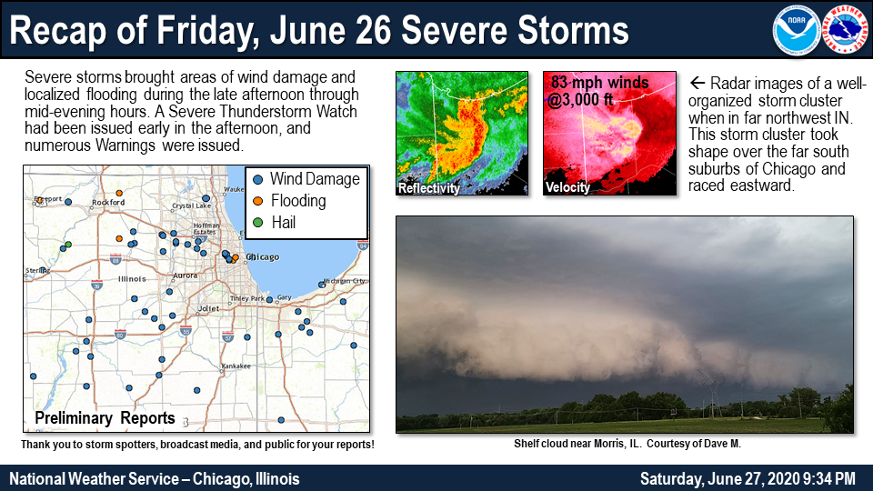
Overview
|
Fast Facts:
For detailed information about the flash flooding that impacted Kentland, IN, see Rainfall Analysis of the June 27th, 2020, Flash Flood in the Vicinity of Kentland, IN, a NWS Technical Paper. |
|
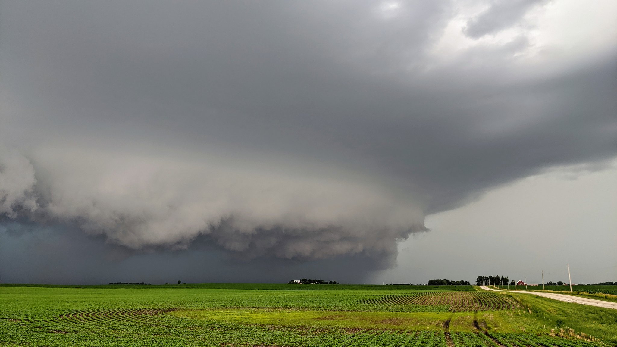
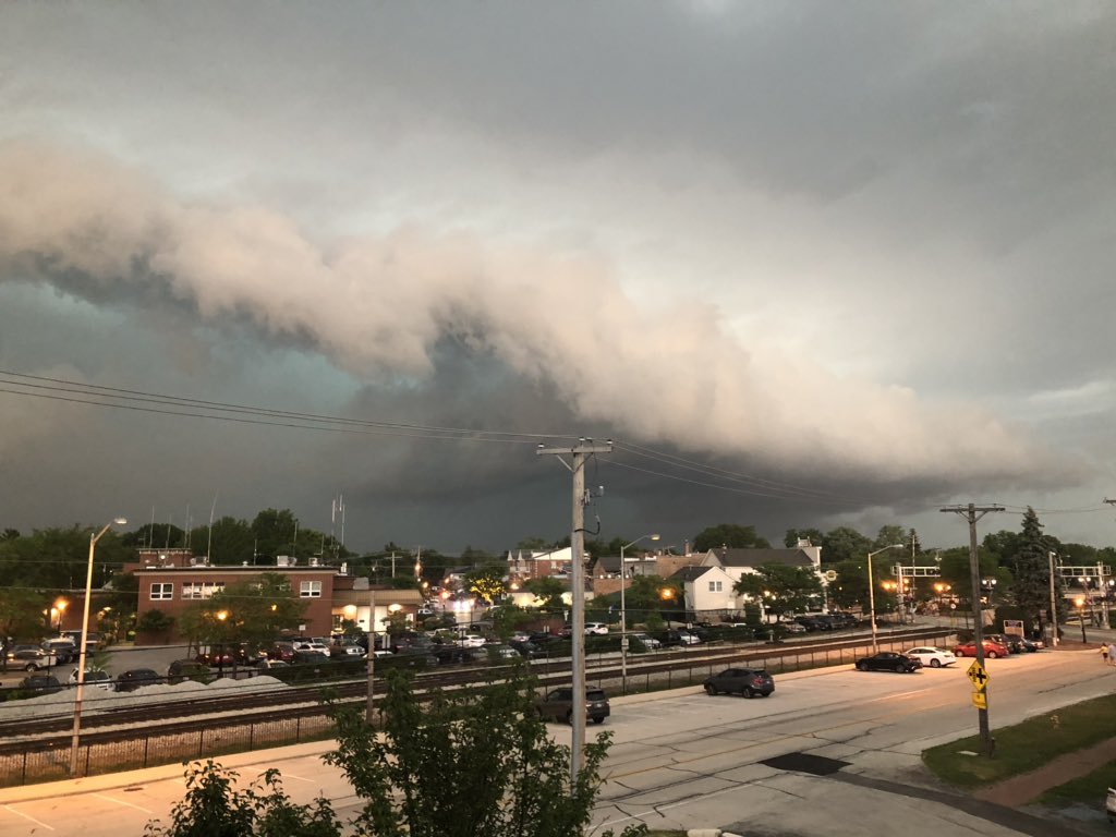
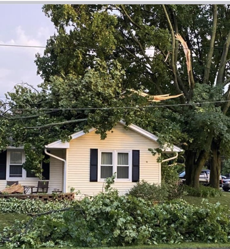
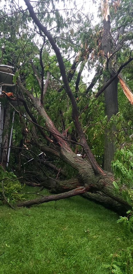
June 26 Wind Damage
 |
 |
| Somonauk, IL courtesy of Bob Waszak | Tinley Park, IL courtesy of Colleen Longoria |
 |
 |
| Grayslake, IL courtesy of Melanie Bruce | Elgin, IL courtesy of Lori Stevens |
PRELIMINARY LOCAL STORM REPORT...SUMMARY
NATIONAL WEATHER SERVICE CHICAGO IL
846 PM CDT SAT JUN 27 2020

..TIME...   ...EVENT...      ...CITY LOCATION...     ...LAT.LON...
..DATE...   ....MAG....      ..COUNTY LOCATION..ST.. ...SOURCE....
            ..REMARKS..

0255 PM     TSTM WND DMG     SLEEPY HOLLOW           42.09N 88.31W
06/26/2020                   KANE               IL   TRAINED SPOTTER

            CORRECTS PREVIOUS REPORT FROM SLEEPY HOLLOW.
            DAMAGE OCCURRED WITH A STORM DURING THE
            EARLY AFTERNOON. AT LEAST TWO UTILITY POLES
            WERE SNAPPED. TIME ESTIMATED.

0520 PM     HAIL             2 ESE OREGON            42.01N 89.30W
06/26/2020  M1.50 INCH       OGLE               IL   PUBLIC

            TIME AND LOCATION ESTIMATED.

0545 PM     TSTM WND DMG     3 SSW OREGON            41.98N 89.35W
06/26/2020                   OGLE               IL   LAW ENFORCEMENT

            SHERIFF REPORTS TREES DOWN NEAR CASTLE ROCK
            STATE PARK IN THE BROOKS ISLAND AREA.

0600 PM     FLOOD            POPLAR GROVE            42.37N 88.82W
06/26/2020                   BOONE              IL   TRAINED SPOTTER

            CREEKS AND DITCHES WERE FULL WITH WATER OVER
            ROADWAYS IN LOW LYING AREAS.

0601 PM     TSTM WND DMG     GENOA                   42.10N 88.69W
06/26/2020                   DE KALB            IL   PUBLIC

            REPORT OF LARGE TREES DOWN RECEIVED VIA
            SOCIAL MEDIA. TIME ESTIMATED BASED ON RADAR.

0608 PM     TSTM WND DMG     2 NW SYCAMORE           42.01N 88.71W
06/26/2020                   DE KALB            IL   TRAINED SPOTTER

            NUMEROUS LARGE TREE LIMBS BLOWN DOWN NEAR
            FREED AND PEACH ROADS. TIME ESTIMATED.

0609 PM     TSTM WND DMG     2 NNE SYCAMORE          42.02N 88.68W
06/26/2020                   DE KALB            IL   TRAINED SPOTTER

            REPORT OF NUMEROUS TREES DOWN BETWEEN
            SYCAMORE AND GENOA WITH A UTILITY POLE ON
            FIRE. TIME AND LOCATION ESTIMATED BASED ON
            RADAR.

0610 PM     TSTM WND DMG     3 WSW DIXON             41.83N 89.54W
06/26/2020                   LEE                IL   EMERGENCY MNGR

            TREES DOWN, INCLUDING ONE ON A HOUSE, IN
            CASTELLAN SUBDIVISION. POWER ALSO OUT IN
            NELSON AREA.

0620 PM     TSTM WND GST     PINGREE GROVE           42.07N 88.41W
06/26/2020  M65 MPH          KANE               IL   TRAINED SPOTTER


0626 PM     TSTM WND DMG     1 N PINGREE GROVE       42.08N 88.42W
06/26/2020                   KANE               IL   PUBLIC

            REPORT FROM MPING: 1-INCH TREE LIMBS BROKEN;
            SHINGLES BLOWN OFF.

0628 PM     FUNNEL CLOUD     1 S PECATONICA          42.29N 89.36W
06/26/2020                   WINNEBAGO          IL   TRAINED SPOTTER

            SPOTTER REPORTED FUNNEL CLOUD 1 MILE SOUTH
            OF PECATONICA. LATER CONFIRMED ON VIDEO.

0629 PM     TSTM WND DMG     2 ESE GRAYSLAKE         42.33N 88.01W
06/26/2020                   LAKE               IL   PUBLIC

            NUMEROUS LARGE LIMBS DOWN IN GRAYSLAKE. TIME
            ESTIMATED BY RADAR.

0630 PM     TSTM WND DMG     2 NNW CAMPTON HILLS     41.96N 88.41W
06/26/2020                   KANE               IL   PUBLIC

            KANE CO ARES SPOTTER REPORT - CAMPTON HILLS
            NEAR BURLINGTON AND EMPIRE, POWER OUT WITH
            LARGE TREE BRANCHES (MAPLE) AND SMALL TREES
            DOWN. TIME ESTIMATED BASED ON RADAR.

0634 PM     TSTM WND DMG     1 SSW ELGIN             42.03N 88.29W
06/26/2020                   KANE               IL   TRAINED SPOTTER

            A 1 FOOT DIAMETER TREE WAS BLOWN DOWN ONTO A
            HOUSE ON OAK STREET.

0635 PM     TSTM WND DMG     1 SE PECATONICA         42.30N 89.34W
06/26/2020                   WINNEBAGO          IL   TRAINED SPOTTER

            TREES DOWN AND POWER OUTAGES REPORTED
            SOUTHEAST OF PECATONICA. TIME ESTIMATED BY
            RADAR.

0644 PM     TSTM WND DMG     1 SW STREAMWOOD         42.01N 88.18W
06/26/2020                   COOK               IL   PUBLIC

            SPOTTER NETWORK REPORT OF A ROUGHLY 6 INCH
            DIAMETER TREE LIMB DOWN ON A CAR. TIME
            ESTIMATED BY.

0647 PM     TSTM WND DMG     ROSELLE                 41.98N 88.09W
06/26/2020                   DUPAGE             IL   TRAINED SPOTTER

            A LARGE TREE WAS SNAPPED ALONG MAPLE AVENUE.
            TIME ESTIMATED.

0647 PM     TSTM WND GST     SCHAUMBURG              42.03N 88.08W
06/26/2020  E60 MPH          COOK               IL   PUBLIC

            WIND GUSTS ESTIMATED BETWEEN 50 MPH AND 60
            MPH.

0651 PM     TSTM WND GST     2 NW ADDISON            41.95N 88.03W
06/26/2020  M71 MPH          DUPAGE             IL   TRAINED SPOTTER

            MEASURED GUST TO 71 MPH NEAR ROUTE 53 AND
            ROUTE 20.

0705 PM     TSTM WND GST     N SOMONAUK              41.63N 88.68W
06/26/2020  E60 MPH          DE KALB            IL   PUBLIC

            AT LEAST 60 MPH WIND GUSTS JUST NORTH OF
            SOMONAUK.

0705 PM     TSTM WND DMG     1 SSW NORRIDGE          41.95N 87.83W
06/26/2020                   COOK               IL   PUBLIC

            POWER LINES WERE BLOWN DOWN NEAR PIONEER AND
            GRACE STREETS. TIME ESTIMATED.

0706 PM     TSTM WND DMG     1 N ELMWOOD PARK        41.93N 87.81W
06/26/2020                   COOK               IL   PUBLIC

            LARGE TREE DOWN ON A CAR AT DIVERSEY AND
            75TH.

0708 PM     TSTM WND DMG     SOMONAUK                41.63N 88.68W
06/26/2020                   DE KALB            IL   PUBLIC

            CORRECTS TIME FROM PREVIOUS REPORT FROM
            SOMONAUK. A 1 TO 2 FOOT DIAMETER TREE WAS
            BLOWN DOWN BLOCKING A ROAD.

0708 PM     TSTM WND DMG     1 S DUNNING - CHICAGO   41.94N 87.81W
06/26/2020                   COOK               IL   PUBLIC

            A TREE WAS BLOWN DOWN ONTO POWER LINES NEAR
            OCONTO AND BARRY AVENUES.

0710 PM     TSTM WND DMG     1 S DUNNING - CHICAGO   41.94N 87.81W
06/26/2020                   COOK               IL   PUBLIC

            TREE DOWN ON POWER LINES.

0711 PM     TSTM WND DMG     1 NNE RIVER GROVE       41.94N 87.83W
06/26/2020                   COOK               IL   PUBLIC

            TWITTER REPORT OF A TREE DOWN BLOCKING THE
            STREET AT PITTSBURGH AND ADDISON. TIME
            ESTIMATED BASED ON RADAR.

0719 PM     TSTM WND DMG     2 NW TROY GROVE         41.48N 89.11W
06/26/2020                   LA SALLE           IL   LAW ENFORCEMENT

            REPORTED ALONG EAST 3RD ROAD. ALSO SPORADIC
            TREE DAMAGE TO THE WEST OF THERE ALONG IL
            251 AND SOUTHEAST OF HERE INTO TROY GROVE.

0721 PM     TSTM WND DMG     2 ESE ELMWOOD PARK      41.91N 87.79W
06/26/2020                   COOK               IL   PUBLIC

            TREES AND WIRES DOWN ON A CAR. TIME
            ESTIMATED BASED ON TWEET AND RADAR DATA.

0723 PM     TSTM WND GST     OSWEGO                  41.68N 88.35W
06/26/2020  E70 MPH          KENDALL            IL   PUBLIC

            WIND GUSTS WERE ESTIMATED BETWEEN 60 MPH AND
            70 MPH.

0723 PM     TSTM WND DMG     1 N OAK PARK            41.90N 87.79W
06/26/2020                   COOK               IL   PUBLIC

            NUMEROUS REPORTS OF TREES AND WIRES DOWN.
            TIME AND LOCATION BASED ON TWEET AND RADAR
            DATA.

0726 PM     MARINE TSTM WIND 3 NE NAVY PIER          41.92N 87.57W
06/26/2020  M54 MPH          LMZ741             IL   PUBLIC

            MEASURED GUST TO 54 MPH AT THE
            HARRISON-DEVER CRIB.

0738 PM     FLOOD            2 N CLARE               42.05N 88.82W
06/26/2020                   DE KALB            IL   FIRE DEPT/RESCUE

            REPORT OF 6 INCHES OF WATER OVER AULT AND
            ALDRICH ROADS SOUTHEAST OF KIRKLAND.

0741 PM     TSTM WND GST     PERU                    41.33N 89.13W
06/26/2020  M72 MPH          LA SALLE           IL   BROADCAST MEDIA

            MEASURED WIND GUST TO 72 MPH AT WLPO.

0741 PM     TSTM WND DMG     PERU                    41.33N 89.13W
06/26/2020                   LA SALLE           IL   BROADCAST MEDIA

            LARGE TREE BLOWN DOWN AND CORN STALKS BENT
            OVER.

0745 PM     TSTM WND DMG     NEWARK                  41.54N 88.58W
06/26/2020                   KENDALL            IL   EMERGENCY MNGR

            TREES DOWN AND POWER OUT FOR A SIGNIFICANT
            PORTION OF NEWARK.

0752 PM     TSTM WND DMG     LISBON                  41.49N 88.49W
06/26/2020                   KENDALL            IL   EMERGENCY MNGR

            A TREE WAS BLOWN DOWN ACROSS ROUTE 52. TIME
            ESTIMATED.

0758 PM     TSTM WND DMG     1 W TONICA              41.22N 89.09W
06/26/2020                   LA SALLE           IL   PUBLIC

            LARGE TREE LIMB BLOWN DOWN PARTIALLY
            BLOCKING A ROAD.

0800 PM     FLASH FLOOD      1 NNE AUSTIN - CHICAGO  41.90N 87.75W
06/26/2020                   COOK               IL   PUBLIC

            REPORT OF SEVERAL CARS STUCK IN FLOODED
            VIADUCTS NEAR DIVISION AND CICERO. REPORT
            RELAYED VIA TWITTER.

0800 PM     FLASH FLOOD      HERMOSA - CHICAGO       41.92N 87.73W
06/26/2020                   COOK               IL   PUBLIC

            REPORT RELAYED VIA TWITTER OF CARS STUCK IN
            FLOODED VIADUCTS NEAR DIVISION AND CICERO.

0801 PM     TSTM WND DMG     3 ESE PLATTVILLE        41.51N 88.32W
06/26/2020                   KENDALL            IL   NWS EMPLOYEE

            ONE FOOT DIAMETER TREE DOWN BLOCKING THE
            RIGHT LANE ON ROUTE 52, TWO MILES WEST OF
            RIDGE ROAD.

0810 PM     MARINE TSTM WIND 4 NE TOWN OF PINES      41.73N 86.92W
06/26/2020  M44 MPH          LMZ745             IN   C-MAN STATION

            38 KT GUST RECORDED AT THE MICHIGAN CITY
            C-MAN STATION.

0813 PM     TSTM WND GST     GARY AIRPORT            41.62N 87.41W
06/26/2020  M58 MPH          LAKE               IN   AWOS

            MEASURED WIND GUST TO 58 MPH AT THE GARY
            AIRPORT.

0815 PM     TSTM WND GST     MORRIS AIRPORT          41.43N 88.42W
06/26/2020  M71 MPH          GRUNDY             IL   AWOS

            MEASURED GUST TO 71 MPH AT THE MORRIS
            AIRPORT.

0840 PM     MARINE TSTM WIND 4 NE TOWN OF PINES      41.73N 86.91W
06/26/2020  M47 MPH          LMZ745             IN   C-MAN STATION

            41 KT GUST RECORDED AT THE MICHIGAN CITY
            C-MAN STATION.

0845 PM     TSTM WND DMG     2 N BEECHER             41.36N 87.62W
06/26/2020                   WILL               IL   AMATEUR RADIO

            A 25-30 FOOT TALL TREE WAS BLOWN OVER ONTO A
            FENCE. WINDS ESTIMATED TO 65 MPH.

0847 PM     TSTM WND GST     3 SE CROWN POINT        41.38N 87.33W
06/26/2020  M65 MPH          LAKE               IN   AMATEUR RADIO

            ESTIMATED WIND GUST TO 65 MPH NEAR 129TH AND
            DELAWARE STREETS.

0859 PM     TSTM WND DMG     3 S MAZON               41.20N 88.42W
06/26/2020                   GRUNDY             IL   EMERGENCY MNGR

            REPORTS OF 10 TO 12 UTILITY POLES SNAPPED
            FROM EARLIER STORMS BETWEEN PRAIRIE AND
            GRINTER ROADS ALONG ROUTE 47. TIME ESTIMATED
            BY CALL TIME AND RADAR.

0900 PM     TSTM WND GST     SOUTH HAVEN             41.54N 87.14W
06/26/2020  E70 MPH          PORTER             IN   PUBLIC


0900 PM     TSTM WND DMG     SOUTH HAVEN             41.54N 87.14W
06/26/2020                   PORTER             IN   TRAINED SPOTTER

            REPORT OF 2-INCH DIAMETER TREE LIMBS DOWN.

0902 PM     TSTM WND DMG     4 SW VALPARAISO         41.43N 87.11W
06/26/2020                   PORTER             IN   911 CALL CENTER

            TREES ON THE ROAD BLOCKING DIVISION AND S
            200 W STREET. TIME ESTIMATED BASED ON RADAR.

0902 PM     TSTM WND DMG     VALPARAISO              41.47N 87.06W
06/26/2020                   PORTER             IN   911 CALL CENTER

            TREES DOWN IN VALPARAISO. TIME ESTIMATED
            BASED ON RADAR. RELAYED BY PORTER COUNTY
            DISPATCH.

0902 PM     TSTM WND DMG     CORNELL                 41.00N 88.73W
06/26/2020                   LIVINGSTON         IL   911 CALL CENTER

            LIVINGSTON DISPATCH RELAYS REPORTS OF
            NUMEROUS TREES AND POWER LINES DOWN
            THROUGHOUT AND IMMEDIATELY NORTH OF CORNELL.
            TIME AND LOCATION ESTIMATES BASED ON CALL
            TIME AND RADAR.

0906 PM     TSTM WND DMG     5 N KOUTS               41.39N 87.03W
06/26/2020                   PORTER             IN   911 CALL CENTER

            NUMEROUS TREES DOWN AND BLOCKING VARIOUS
            ROADWAYS THROUGHOUT MORGAN TOWNSHIP. TIME
            ESTIMATED BASED ON RADAR. RELAYED BY PORTER
            COUNTY DISPATCH.

0910 PM     TSTM WND DMG     1 W DWIGHT              41.09N 88.45W
06/26/2020                   LIVINGSTON         IL   911 CALL CENTER

            LIVINGSTON COUNTY DISPATCH RELAYED REPORTS
            OF AT LEAST 2 SEMIS ROLLED JUST WEST OF
            DWIGHT DUE TO THUNDERSTORMS. TIME ESTIMATED
            BASED ON CALL LOG TIME AND RADAR.

1215 AM     TSTM WND DMG     GOODLAND                40.77N 87.30W
06/27/2020                   NEWTON             IN   911 CALL CENTER

            REPORTS OF POWERLINES AND TREES DOWN NEAR
            NEWTON STREET AND WAYLAND AVENUE RELAYED BY
            NEWTON COUNTY SO. TIME ESTIMATED BASED ON
            RADAR AND CALL LOG TIME.


&&

$$
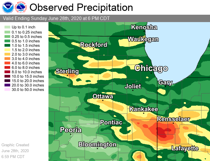
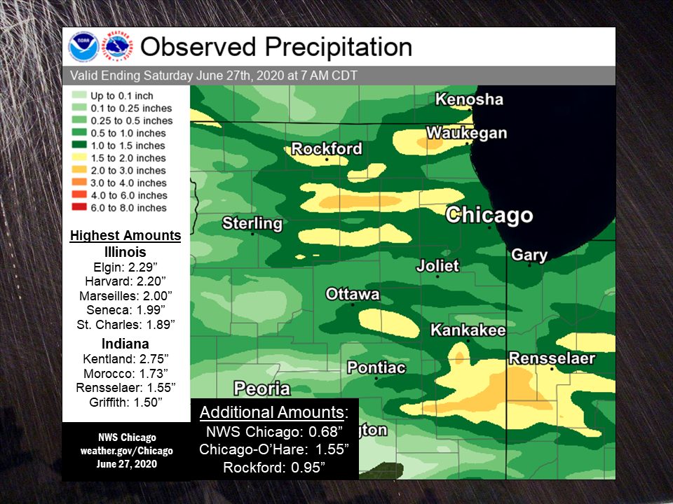
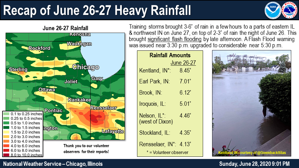
June 26-27 Rain Reports
 |
 |
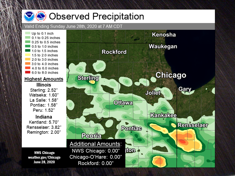 |
| Rainfall on the day and night of Friday-Saturday, June 26-27. | Rainfall on the day and night of Friday, June 26. | Rainfall on the day and night of Saturday, June 27. |
Friday, June 26:

Public Information Statement
National Weather Service Chicago IL
1129 AM CDT Sat Jun 27 2020

...Friday, June 26 2020 Rainfall Totals...

   The following are rain amounts for the previous 24-hours
   as measured in the morning by NWS Cooperative Observers
   and CoCoRaHS observers.
   Observations are usually taken between 6 AND 8 AM.

   24-hour rainfall amounts
       for Saturday(06/27/20)...


Illinois                                       Rain
  Location (County):                           fall (inches)

  Elgin 2W (Kane)..............................2.29
  Harvard 3SSE (McHenry).......................2.20
  Elgin (Kane).................................2.11
  Elgin 1S (Kane)..............................2.11
  Marseilles Lock & Dam (La Salle).............2.00
  Seneca 1NNE (La Salle).......................1.99
  St. Charles 6NW (Kane).......................1.89
  Round Lake 2WNW (Lake).......................1.89
  Ashkum 5.6E (Iroquois).......................1.85
  Lake Villa 2WSW (Lake).......................1.85
  Waukegan (Lake)..............................1.85
  Chebanse (Kankakee)..........................1.80
  Genoa (De Kalb)..............................1.79
  Hebron (McHenry).............................1.79
  Countryside 1ENE (Cook)......................1.79
  Elgin (Kane).................................1.70
  Woodstock 5nw (McHenry)......................1.70
  Oak Park 1NNE (Cook).........................1.69
  Sugar Grove 1ENE (Kane)......................1.69
  Batavia 1WSW (Kane)..........................1.68
  Gurnee 2W (Lake).............................1.65
  Arlington Heights 1SW (Cook).................1.62
  Naperville 2ESE (Du Page)....................1.61
  Woodstock 4SW (McHenry)......................1.60
  Villa Park 1NW (Du Page).....................1.57
  Aurora (Kane)................................1.56
  Streamwood 1W (Cook).........................1.56
  Sugar Grove 1NE (Kane).......................1.56
  Winthrop Harbor (Lake).......................1.56
  Midway (Cook)................................1.56
  Bridgeview 1NNW (Cook).......................1.55
  Bartlett 1SE (Du Page).......................1.55
  Bull Valley 2WNW (McHenry)...................1.55
  Ohare Airport (Cook).........................1.55
  Kingston 2WNW (De Kalb)......................1.54
  Romeoville (Will)............................1.54
  Chicago 6ESE (Cook)..........................1.53
  Roselle 1ESE (Du Page).......................1.53
  Steward (Lee)................................1.53
  Lansing (Cook)...............................1.52
  Schaumburg 2E (Cook).........................1.52
  Lakemoor 2NW (McHenry).......................1.52
  Channahon 2SSE (Will)........................1.51
  Chicago 6NNE (Cook)..........................1.50
  St Anne (Kankakee)...........................1.50
  Batavia (Kane)...............................1.49
  Hoffman Estates 2SE (Cook)...................1.49
  Park Ridge 1WNW (Cook).......................1.45
  Rockford 2ENE (Winnebago)....................1.45
  Rogers Park 2SW (Cook).......................1.44
  Harwood Heights (Cook).......................1.44
  Lincolnwood 2E (Cook)........................1.44
  North Aurora 2NE (Kane)......................1.44
  Wheaton 2NNE (Du Page).......................1.42
  Manhattan 2SE (Will).........................1.42
  Morris 5NNW (Grundy).........................1.40
  Crystal Lake 1WSW (McHenry)..................1.40
  McHenry (Stratton Lock & Dam) (McHenry)......1.40
  Arlington Heights 1S (Cook)..................1.39
  Hoffman Estates 5W (Cook)....................1.38
  Ravenswood Manor (Cook)......................1.38
  Sterling 4NE (Lee)...........................1.38
  Schaumburg (Du Page).........................1.37
  Aurora (Kane)................................1.37
  Glen Ellyn 1WSW (Du Page)....................1.35
  Elmhurst (Du Page)...........................1.35
  Watseka 6.9WNW (Iroquois)....................1.35
  Flossmoor 1ESE (Cook)........................1.34
  Oak Park 1SW (Cook)..........................1.34
  Aurora 4SE (Du Page).........................1.33
  Naperville 1NW (Du Page).....................1.32
  Dwight 4NNW (Grundy).........................1.32
  Amboy (Lee)..................................1.30
  Kankakee (Kankakee)..........................1.30
  Geneva 4WSW (Kane)...........................1.30
  Midway Coop (Cook)...........................1.30
  Lisle (Du Page)..............................1.29
  Bolingbrook 3NE (Du Page)....................1.27
  Minooka (Grundy).............................1.27
  Elmhurst 2SE (Du Page).......................1.25
  Elk Grove Village 2WSW (Cook)................1.24
  Herscher 3E (Kankakee).......................1.24
  Manhattan 1ESE (Will)........................1.24
  Ottawa (La Salle)............................1.24
  Park Ridge (Cook)............................1.23
  Elk Grove Village 1ESE (Cook)................1.23
  Pontiac 1SE (Livingston).....................1.23
  Batavia 2WNW (Kane)..........................1.21
  Chatsworth (Livingston)......................1.20
  Aurora 4SE (Du Page).........................1.20
  Batavia 1WNW (Kane)..........................1.19
  Palos Park 1SW (Cook)........................1.18
  Geneva 1SSW (Kane)...........................1.18
  De Kalb (De Kalb)............................1.17
  Roscoe 2ESE (Winnebago)......................1.17
  Roscoe 2se (Winnebago).......................1.17
  Bourbonnais (Kankakee).......................1.16
  Homewood (Cook)..............................1.15
  Oak Park 2S (Cook)...........................1.12
  Waukegan 2N (Lake)...........................1.11
  Lemont (Cook)................................1.10
  Buckley (Iroquois)...........................1.10
  Capron (Boone)...............................1.09
  Palatine 1NNE (Cook).........................1.08
  Lincolnwood 3E (Cook)........................1.07
  Midlothian (Cook)............................1.07
  Glencoe (Cook)...............................1.07
  Wheeling (Cook)..............................1.05
  Lombard 1NNW (Du Page).......................1.04
  Ottawa (La Salle)............................1.04
  Willow Springs (Cook)........................1.02
  Ottawa 1NW (La Salle)........................1.01
  Barrington (Lake)............................0.98
  Burr Ridge 2SW (Du Page).....................0.98
  Montgomery 1SSE (Kendall)....................0.98
  Channahon 1NNE (Will)........................0.97
  Coal City (Grundy)...........................0.96
  Chicago 5NE (Cook)...........................0.95
  Rockford (Winnebago).........................0.95
  Beecher 3ENE (Will)..........................0.94
  Naperville 4SSW (Will).......................0.93
  Morris 2SSE (Grundy).........................0.91
  De Kalb 1SW (De Kalb)........................0.90
  Morris 6ESE (Grundy).........................0.90
  Lockport 1SE (Will)..........................0.90
  Brandon Road Lock & Dam (Will)...............0.90
  Midlothian 1SE (Cook)........................0.89
  Carbon Hill 3.1N (Grundy)....................0.89
  Peotone (Will)...............................0.89
  St. Charles (Kane)...........................0.88
  Peru 1ENE (La Salle).........................0.88
  Elburn (Kane)................................0.87
  Ashton (Lee).................................0.87
  Wilmington 3SE (Will)........................0.87
  Ottawa 2N (La Salle).........................0.86
  Monee (Will).................................0.86
  New Lenox 3ENE (Will)........................0.85
  Morris (Grundy)..............................0.85
  Cortland (De Kalb)...........................0.84
  New Lenox 3E (Will)..........................0.84
  La Salle (La Salle)..........................0.83
  Wilmington 6NW (Will)........................0.83
  Plano (Kendall)..............................0.82
  Mokena 1W (Will).............................0.82
  New Lenox 2SE (Will).........................0.82
  Lake Zurich 1N (Lake)........................0.81
  Elwood 5NE (Will)............................0.81
  Oak Lawn 2WNW (Cook).........................0.80
  Somonauk 2NE (De Kalb).......................0.80
  Earlville 5NNE (De Kalb).....................0.80
  Coal City 3N (Grundy)........................0.80
  Manhattan (Will).............................0.76
  Dwight (Livingston)..........................0.75
  North Utica 6N (La Salle)....................0.75
  Manhattan 5ENE (Will)........................0.75
  Gilberts (Kane)..............................0.74
  Park Forest 1NNE (Cook)......................0.73
  Mundelein 2WNW (Lake)........................0.73
  Lake Bluff 1W (Lake).........................0.71
  Buffalo Grove 2N (Lake)......................0.71
  Emington 2SSE (Livingston)...................0.71
  Plainfield 5SW (Kendall).....................0.69
  Lake Forest 2NNE (Lake)......................0.69
  Plainfield 3ESE (Will).......................0.68
  Mundelein (Lake).............................0.66
  Plainfield 2SSE (Will).......................0.64
  Lake Zurich (Lake)...........................0.64
  Crete 3E (Will)..............................0.63
  Joliet (Will)................................0.63
  Earlville 3S (La Salle)......................0.62
  Libertyville 2ESE (Lake).....................0.62
  Beecher 3SSE (Will)..........................0.62
  Pontiac (Livingston).........................0.61
  Rochelle (Ogle)..............................0.58
  Joliet 3WNW (Will)...........................0.57
  Bannockburn (Lake)...........................0.54
  Peru (La Salle)..............................0.54
  Dixon 3NNW (Lee).............................0.53
  Riverwoods (Lake)............................0.52
  Highwood 1S (Lake)...........................0.52
  Peru 1SW (La Salle)..........................0.52
  Joliet 2n (Will).............................0.50
  Mendota (La Salle)...........................0.46
  Mendota (La Salle)...........................0.39
  Gibson 6NE (Ford)............................0.29
  South Beloit 2SE (Winnebago).................0.28
  Paxton (Ford)................................0.15
  Gibson 3WNW (Ford)...........................0.14
  Paxton (Ford)................................0.07

Indiana                                        Rain
  Location (County):                           fall (inches)

  Kentland 2SSE (Newton).......................2.75
  Kentland (Newton)............................2.49
  Morocco (Newton).............................1.73
  Rensselaer 5NW (Jasper)......................1.55
  Rensselaer 4N (Jasper).......................1.51
  Griffith 1N (Lake)...........................1.50
  Rensselaer (Jasper)..........................1.35
  Hobart 2E (Lake).............................1.29
  Hobart 1SSW (Lake)...........................1.28
  Mount Ayr 2NNE (Newton)......................1.27
  Hammond 1SSW (Lake)..........................1.26
  Remington (Jasper)...........................1.24
  Rensselaer 10NNE (Jasper)....................1.21
  Rensselaer 2SSW (Jasper).....................1.20
  Valparaiso 2N (Porter).......................1.16
  Valparaiso 1NNW (Porter).....................1.10
  Rensselaer 8ENE (Jasper).....................1.07
  Dyer 1WNW (Lake).............................1.07
  De Motte 6S (Jasper).........................1.05
  Valparaiso 2WNW (Porter).....................1.05
  Chesterton 4E (Porter).......................1.05
  Hebron 1NW (Porter)..........................1.05
  Portage 3E (Porter)..........................1.02
  Wheatfield 5W (Jasper).......................1.00
  Schererville 1E (Lake).......................1.00
  Valparaiso 2WSW (Porter).....................1.00
  Valparaiso 2NW (Porter)......................0.97
  De Motte 1NNW (Jasper).......................0.96
  Valparaiso 1NE (Porter)......................0.94
  Crown Point (Lake)...........................0.92
  Crown Point 1N (Lake)........................0.92
  Schererville 1E (Lake).......................0.90
  De Motte 1SSW (Jasper).......................0.89
  Munster 2NNW (Lake)..........................0.86
  Gary 5ENE (Lake).............................0.85
  Chesterton 1ENE (Porter).....................0.85
  Valparaiso (Porter)..........................0.82
  Porter 1S (Porter)...........................0.80
  Wheatfield 4WSW (Jasper).....................0.78
  Lakes Of The Four Seasons (Porter)...........0.78
  Valparaiso 4SW (Porter)......................0.77
  De Motte 4SW (Jasper)........................0.75
  St. John (Lake)..............................0.64
  Valparaiso 6SSW (Porter).....................0.63
  Valparaiso 5WSW (Porter).....................0.49

$$
Saturday, June 27:
Public Information Statement
National Weather Service Chicago IL
1011 AM CDT Sun Jun 28 2020

...Morning Rainfall Roundup...

   The following are rain amounts for the previous 24-hours
   as measured in the morning by NWS Cooperative Observers
   and CoCoRaHS observers.
   Observations are usually taken between 6 AND 8 AM.

   24-hour rainfall amounts
       for Sunday(06/28/20)...


Illinois                                       Rain
  Location (County):                           fall (inches)

  Sterling 4NE (Lee)...........................2.52
  Watseka 6.9WNW (Iroquois)....................1.60
  La Salle (La Salle)..........................1.58
  Pontiac 1SE (Livingston).....................1.58
  Peru 1ENE (La Salle).........................1.52
  Peru (La Salle)..............................1.41
  Ashkum 5.6E (Iroquois).......................1.36
  Herscher 3E (Kankakee).......................1.31
  Peru 1SW (La Salle)..........................1.24
  Chebanse (Kankakee)..........................1.23
  Ottawa (La Salle)............................0.92
  Dixon 3NNW (Lee).............................0.86
  St Anne (Kankakee)...........................0.84
  Ottawa 2N (La Salle).........................0.83
  Manteno 2NW (Kankakee).......................0.80
  North Aurora 2NE (Kane)......................0.75
  Ottawa 1NW (La Salle)........................0.62
  Peotone (Will)...............................0.59
  North Utica 6N (La Salle)....................0.58
  Wilmington 3SE (Will)........................0.58
  Pontiac (Livingston).........................0.57
  Cissna Park 1S (Iroquois)....................0.51
  Paxton (Ford)................................0.49
  Manhattan 5ENE (Will)........................0.45
  Manhattan (Will).............................0.44
  Ottawa (La Salle)............................0.38
  Bourbonnais (Kankakee).......................0.22
  Mendota (La Salle)...........................0.18
  Midlothian (Cook)............................0.15
  Dwight 4NNW (Grundy).........................0.15
  Coal City 3N (Grundy)........................0.15
  Seneca 1NNE (La Salle).......................0.13
  Glen Ellyn 1WSW (Du Page)....................0.10
  Paxton (Ford)................................0.10
  Dekalb (De Kalb).............................0.09
  Monee (Will).................................0.09
  Morris 2SSE (Grundy).........................0.06
  Dwight (Livingston)..........................0.05
  Palos Park 1SW (Cook)........................0.05
  Aurora (Kane)................................0.04
  Coal City 4NNW (Grundy)......................0.04
  Carbon Hill 3.1N (Grundy)....................0.04
  Mendota (La Salle)...........................0.04
  Earlville 3S (La Salle)......................0.03
  Homewood (Cook)..............................0.03
  Morris 5NNW (Grundy).........................0.03
  Plainfield 3ESE (Will).......................0.03
  Park Forest 1NNE (Cook)......................0.02
  Bolingbrook 3NE (Du Page)....................0.02
  Naperville 1NW (Du Page).....................0.02
  Homer Glen 1ENE (Will).......................0.02
  Batavia (Kane)...............................0.01
  Lisle 1SE (Du Page)..........................0.01
  Lombard 1NNW (Du Page).......................0.01
  Gibson 3WNW (Ford)...........................0.01
  Gibson 6NE (Ford)............................0.01
  Woodstock 4SW (McHenry)......................0.01
  Channahon 2SSE (Will)........................0.01
  Steward (Lee)................................0.01
  Glencoe (Cook)..............................TRACE
  Aurora 4NE (Du Page)........................TRACE
  Coal City (Grundy)..........................TRACE
  Morris 6ESE (Grundy)........................TRACE
  Geneva 4WSW (Kane)..........................TRACE
  Lake Zurich 1N (Lake).......................TRACE
  Emington 2SSE (Livingston)..................TRACE
  Beecher 3SSE (Will).........................TRACE
  Naperville 4SSW (Will)......................TRACE
  Wilmington 6NW (Will).......................TRACE
  Park Forest (Cook)..........................TRACE

Indiana                                        Rain
  Location (County):                           fall (inches)

  Kentland 2SSE (Newton).......................5.70
  Kentland (Newton)............................3.82
  Rensselaer 2SSW (Jasper).....................3.03
  Rensselaer (Jasper)..........................2.78
  Remington (Jasper)...........................2.00
  Rensselaer 8ENE (Jasper).....................0.52
  Mount Ayr 2NNE (Newton)......................0.45
  Rensselaer 5NW (Jasper)......................0.12
  Rensselaer 4N (Jasper).......................0.05
  De Motte 6S (Jasper).........................0.03
  Gary 5ENE (Lake).............................0.02
  De Motte 1SSW (Jasper)......................TRACE
  De Motte 4SW (Jasper).......................TRACE

$$
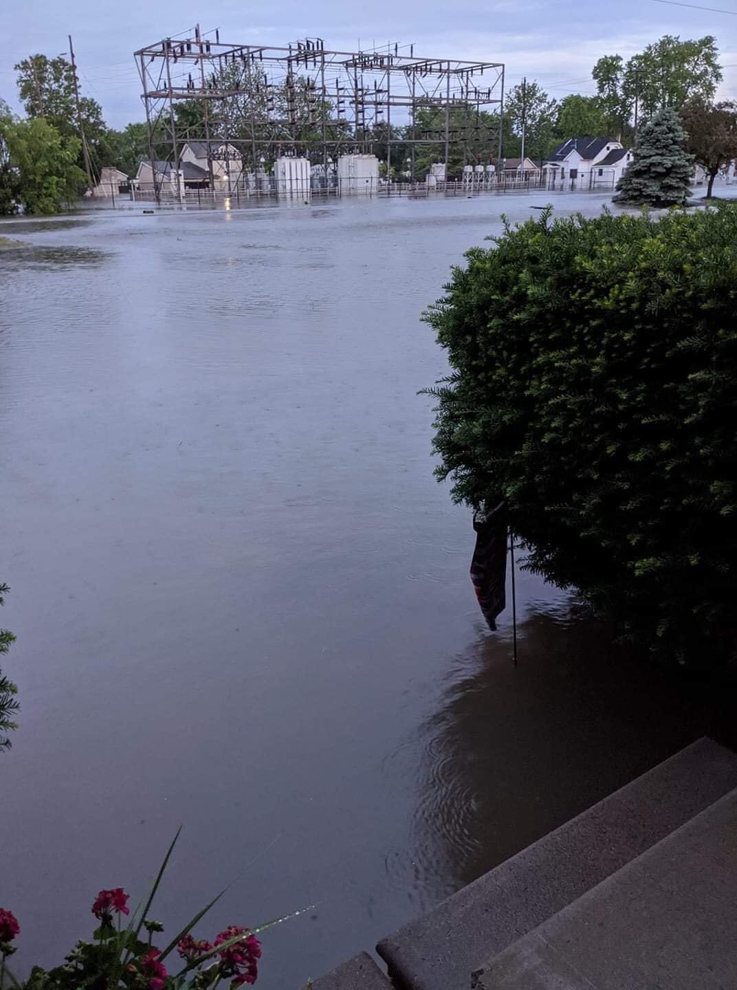
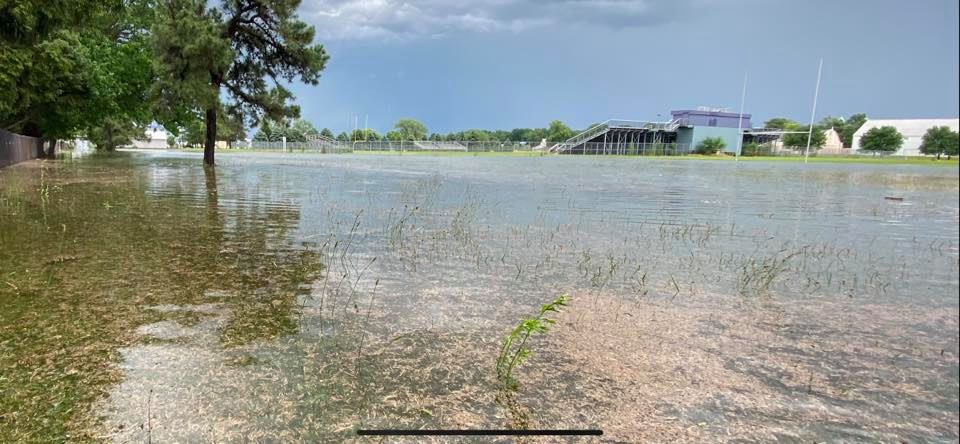
June 27 Flash Flooding
 |
|
| Kentland, IN courtesy of Twitter user @GreenbackSilas | Rensselaer, IN courtesy of Jim Mullet |
PRELIMINARY LOCAL STORM REPORT...SUMMARY
NATIONAL WEATHER SERVICE CHICAGO IL
647 PM CDT SUN JUN 28 2020

..TIME...   ...EVENT...      ...CITY LOCATION...     ...LAT.LON...
..DATE...   ....MAG....      ..COUNTY LOCATION..ST.. ...SOURCE....
            ..REMARKS..

0415 PM     FLASH FLOOD      COLLEGEVILLE            40.91N 87.16W
06/27/2020                   JASPER             IN   LAW ENFORCEMENT

            WATER UP TO 2 FEET IN DEPTH REPORTED ON
            ROADS IN AND SOUTH OF RENSSELAER. PHOTOS OF
            FLOODING IN THE AREA ALSO SENT IN ON SOCIAL
            MEDIA.

0449 PM     TSTM WND DMG     4 ENE STELLE            40.98N 88.09W
06/27/2020                   IROQUOIS           IL   TRAINED SPOTTER

            TREES DOWNED AND SPLIT IN HALF.

0600 PM     FLASH FLOOD      1 S KENTLAND            40.76N 87.44W
06/27/2020                   NEWTON             IN   PUBLIC

            VIDEO SHOWING FLASH FLOODING OCCURRING AT
            KENT DITCH.

0600 PM     FLASH FLOOD      2 S KENTLAND            40.74N 87.44W
06/27/2020                   NEWTON             IN   EMERGENCY MNGR

            NUMEROUS ROADS FLOODED IN SOUTHERN NEWTON
            COUNTY NEAR KENTLAND. VEHICLES ABANDONED IN
            FLOOD WATERS. GRAVEL ROADS WASHED AWAY ALONG
            BENTON COUNTY LINE.

0650 PM     FLASH FLOOD      1 N HERSCHER            41.06N 88.10W
06/27/2020                   KANKAKEE           IL   LAW ENFORCEMENT

            OVER A FOOT OF WATER ON ILLINOIS 115 AND
            S12000W RD.

0720 PM     HEAVY RAIN       KENTLAND                40.78N 87.44W
06/27/2020  M2.00 INCH       NEWTON             IN   COCORAHS

            2 INCHES OF RAIN RECORDED IN LAST 3 HOURS.
            STORM TOTAL OF 3.7 INCHES AS OF 7:20 PM.
            THIS IS IN ADDITION TO 2.49 INCHES OF RAIN
            THAT FELL LAST NIGHT.

0720 PM     FLASH FLOOD      5 ENE STELLE            40.97N 88.06W
06/27/2020                   IROQUOIS           IL   TRAINED SPOTTER

            CREEK OUT OF ITS BANKS AND WATER FLOWING
            OVER NEARBY ROAD. NEARBY DITCHES FLOODED.

0830 PM     HEAVY RAIN       4 ESE EARL PARK         40.67N 87.34W
06/27/2020  M7.01 INCH       BENTON             IN   MESONET

            RAINFALL SINCE MIDNIGHT MEASURED BY A
            PERSONAL WEATHER STATION. APPROXIMATELY 5.5
            INCHES OF RAIN FELL BETWEEN 330 AND 7 PM ET.

0830 PM     HEAVY RAIN       KENTLAND                40.77N 87.45W
06/27/2020  M7.76 INCH       NEWTON             IN   MESONET

            RAINFALL SINCE MIDNIGHT MEASURED BY A
            PERSONAL WEATHER STATION. APPROXIMATELY 5
            INCHES OF RAIN FELL BETWEEN 2 AND 6 PM CT.

0830 PM     HEAVY RAIN       REMINGTON               40.76N 87.15W
06/27/2020  M3.59 INCH       JASPER             IN   MESONET

            RAINFALL SINCE MIDNIGHT MEASURED BY A
            PERSONAL WEATHER STATION.

0830 PM     HEAVY RAIN       2 NNW SHELDON           40.79N 87.58W
06/27/2020  M4.36 INCH       IROQUOIS           IL   MESONET

            RAINFALL SINCE MIDNIGHT MEASURED BY A
            PERSONAL WEATHER STATION. APPROXIMATELY 2
            INCHES OF RAIN FELL BETWEEN 245 AND 545 PM
            CT.

0900 PM     HEAVY RAIN       4 SW BROOK              40.84N 87.42W
06/27/2020  M6.12 INCH       NEWTON             IN   MESONET

            RAINFALL SINCE MIDNIGHT MEASURED BY A
            PERSONAL WEATHER STATION.

0900 PM     HEAVY RAIN       1 NNE EARL PARK         40.70N 87.40W
06/27/2020  M6.26 INCH       BENTON             IN   MESONET

            RAINFALL SINCE MIDNIGHT MEASURED BY A
            PERSONAL WEATHER STATION.

0900 PM     HEAVY RAIN       2 E IROQUOIS            40.83N 87.54W
06/27/2020  M5.01 INCH       IROQUOIS           IL   MESONET

            RAINFALL SINCE MIDNIGHT MEASURED BY A
            PERSONAL WEATHER STATION.

0900 PM     HEAVY RAIN       5 NW REMINGTON          40.81N 87.21W
06/27/2020  M5.46 INCH       JASPER             IN   MESONET

            RAINFALL SINCE MIDNIGHT MEASURED BY A
            PERSONAL WEATHER STATION.

0900 PM     HEAVY RAIN       3 NNW STOCKLAND         40.65N 87.61W
06/27/2020  M4.35 INCH       IROQUOIS           IL   MESONET

            RAINFALL SINCE MIDNIGHT MEASURED BY A
            PERSONAL WEATHER STATION. APPROXIMATELY 2.3
            INCHES OF RAIN FELL BETWEEN 530 AND 630 PM
            CT.

0915 PM     FLASH FLOOD      3 N NELSON              41.84N 89.59W
06/27/2020                   LEE                IL   EMERGENCY MNGR

            SEVERAL ROADS FLOODED ON THE WEST SIDE OF
            DIXON AND AREAS WEST OF DIXON. ESTIMATED
            WATER DEPTH OF 4 TO 6 INCHES ON SAUK RD
            NORTH OF LINCOLN HWY.

1000 PM     FLASH FLOOD      3 NNE HARMON            41.76N 89.52W
06/27/2020                   LEE                IL   EMERGENCY MNGR

            US ROUTE 30 FLOODED WEST OF HOYLE RD.

1000 PM     FLOOD            3 ENE NELSON            41.81N 89.55W
06/27/2020                   LEE                IL   LAW ENFORCEMENT

            1 FOOT OF STANDING WATER REPORTED AT
            INTERSECTION OF ROCK ISLAND RD AND HARMON
            RD.

1000 PM     HEAVY RAIN       3 NE NELSON             41.83N 89.55W
06/27/2020  M3.32 INCH       LEE                IL   MESONET

            MULTIPLE PERSONAL WEATHER STATIONS REPORTED
            MORE THAN 2.5 INCHES OF RAIN BETWEEN
            STERLING AND DIXON BETWEEN 815 AND 10 PM CT,
            WITH THE HIGHEST OF 3.32 INCHES NEAR
            WOODLAND SHORES.

1017 PM     FLASH FLOOD      2 NE NELSON             41.82N 89.57W
06/27/2020                   LEE                IL   BROADCAST MEDIA

            6 TO 8 INCHES OF WATER MOVING QUICKLY IN
            ROCK RIVER ESTATES NEIGHBORHOOD WEST OF
            DIXON. VEHICLES WITH WATER UP TO THEIR
            BOTTOMS.

0700 AM     HEAVY RAIN       6 E ASHKUM              40.88N 87.85W
06/28/2020  M3.21 INCH       IROQUOIS           IL   COCORAHS

            COCORAHS STATION IL-IR-2 ASHKUM 6 E. 24-HOUR
            TOTAL.

0700 AM     HEAVY RAIN       2 SSE KENTLAND          40.75N 87.43W
06/28/2020  M5.70 INCH       NEWTON             IN   COCORAHS

            COCORAHS STATION IN-NW-6 KENTLAND 2 SSE.
            THIS IS A 24-HOUR TOTAL.

0730 AM     HEAVY RAIN       1 NW COLLEGEVILLE       40.92N 87.18W
06/28/2020  M4.13 INCH       JASPER             IN   CO-OP OBSERVER

            CO-OP OBSERVER STATION RZZI3 RENSSELAER 2
            SW. 24-HOUR TOTAL.

0800 AM     HEAVY RAIN       3 NNW NELSON            41.83N 89.62W
06/28/2020  M3.90 INCH       LEE                IL   COCORAHS

            COCORAHS STATION IL-LE-5 NELSON 3 NNW.
            24-HOUR TOTAL.

0800 AM     HEAVY RAIN       REMINGTON               40.77N 87.15W
06/28/2020  M3.24 INCH       JASPER             IN   COCORAHS

            COCORAHS STATION IN-JS-47 REMINGTON. 24-HOUR
            TOTAL.

0853 AM     HEAVY RAIN       GOODLAND                40.77N 87.29W
06/28/2020  M3.85 INCH       NEWTON             IN   COCORAHS

            COCORAHS STATION IN-NW-17 GOODLAND. 24-HOUR
            TOTAL.


&&

$$
Environment & Additional Info
 |
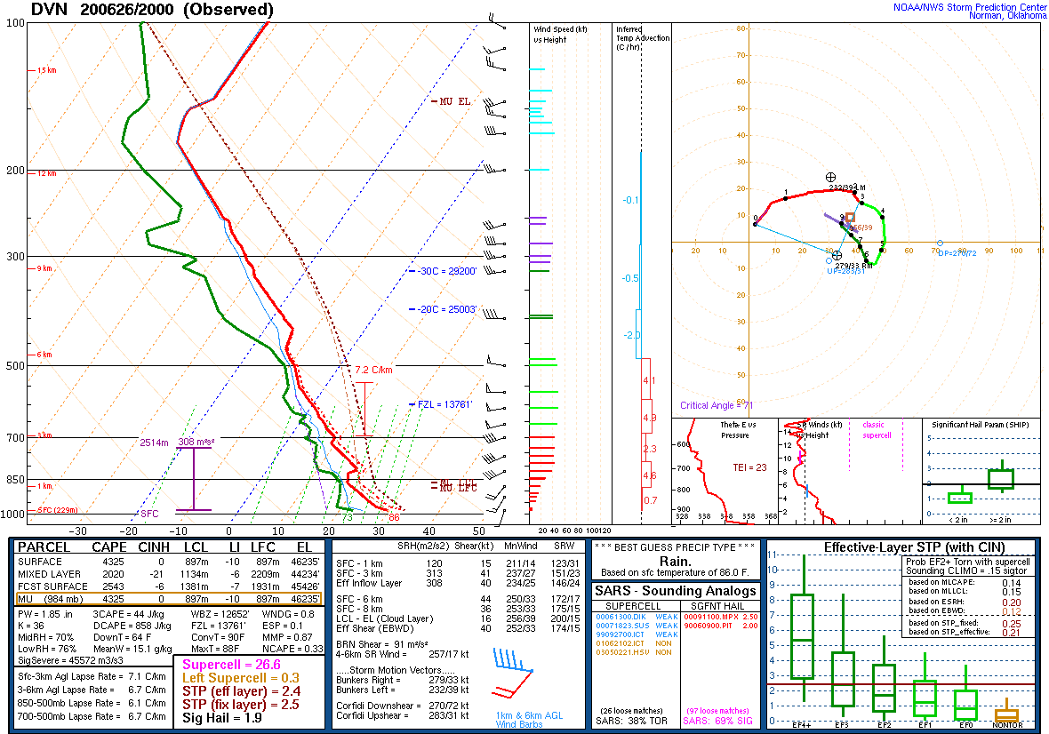 |
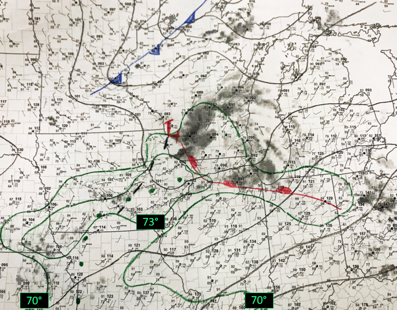
| June 26 4 p.m. surface map depicting a favorable setup for severe storms. A slowly northward-moving warm front was across the area, with a strong upper level wave moving eastward into southern Wisconsin (as evidenced by the ongoing showers and storms at the time of this map). The ample moisture up to the warm front fed into the storms and also helped supply plentiful instability to support strong thunderstorm winds to reach the surface. | June 26 2 p.m. weather balloon launch data (sounding) from NWS Quad Cities. This sounding shows many ideal characteristics for explosive severe weather, especially well-organized, wind-producing storms. This includes high instability, ample moisture, and an impressively strong mid-level wind field. |
 |
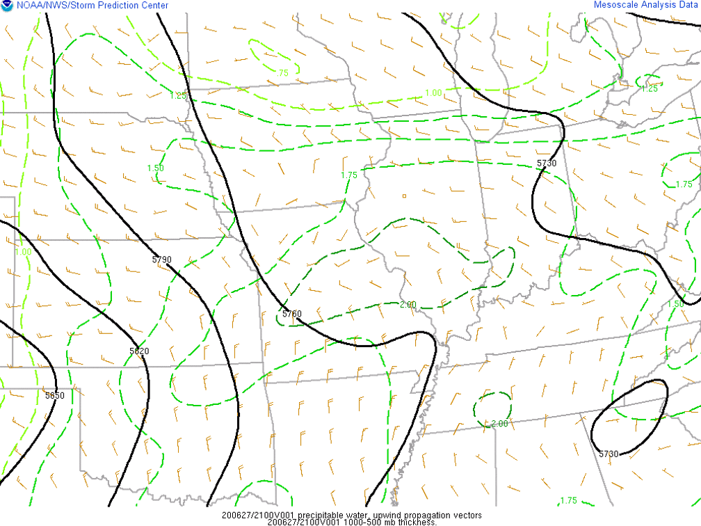 |
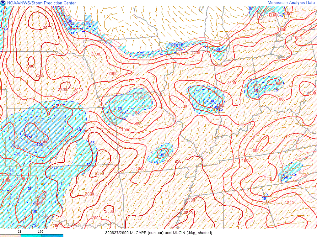
| June 27 3 p.m. Mixed-layer CAPE showing a reservoir of 2,000 J/kg in northwest Indiana where thunderstorms had started to fire. Also notice the low-level wind field and the general convergence from Illinois into that portion of Indiana, serving as a focus for thunderstorms. | June 27 3 p.m. Precipitable waters and steering vectors. High precipitable waters of 1.75"+ and motions that were training along the boundary orientation resulted in flash flooding. |
 |
Media use of NWS Web News Stories is encouraged! Please acknowledge the NWS as the source of any news information accessed from this site. Additional recaps can be found on the NWS Chicago Past Events Page |
|


 Follow us on YouTube