|
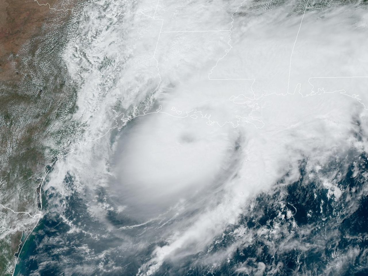
Above: GOES 16 GeoColor Satellite Image of Hurricane Francine off the South Central Louisiana coast at 1:36 PM CDT September 11, 2024.
Francine originated from a tropical wave that emerged off the West coast of Africa on August 28th. The wave traversed the tropical Atlantic ocean with little additional organization, reaching the Leeward Island by September 1st. Showers and thunderstorms increased with the wave as it continued across the Caribbean Sea, but unfavorable upper-level winds prevented additional organization. The tropical wave reached the Yucatán Peninsula by September 6th, emerged into the Bay of Campeche by September 7th, with a broad surface low pressure noted by September 8th. By daybreak on September 9th, an Air-Force reconnaissance aircraft found a closed surface circulation, with the system notably better organized on satellite imagery. At 10 AM CDT, the system was upgraded to Tropical Storm Francine by 10 AM CDT about 250 miles southeast of Brownsville, Texas. Francine moved slowly northwest around 5 mph through the evening hours, slowly strengthening and eventually stalled overnight.
By daybreak on September 10th, an approaching mid to upper-level trough over Texas and Mexico began to cause Tropical Storm Francine to move northeast at 5 to 10 mph. Increasing wind shear and intrusions of mid-level dry air initially halted additional development for the remainder of the afternoon. By the early evening hours, both NOAA and Air-Force reconnaissance aircraft found sustained hurricane force winds at the surface, with Francine being upgraded to a hurricane by 7 PM CDT with sustained winds of 75 mph. Data from reconnaissance aircraft, satellite and land-based radar imagery continued to indicate the intensification of Francine for the remainder of the evening, with maximum sustained winds of 90 mph by 1 AM September 11th located 275 miles southwest of Morgan City, Louisiana.
Hurricane Francine continued to move northeast at 10 mph towards the Louisiana coast, with the intensification trend leveling off through daybreak September 11th. By the late morning and early afternoon hours, land-based radar and satellite imagery showed increased organization. A Lake Charles, LA WSR-88D radar image at 1:06 PM CDT and a GOES 16 GeoColor satellite image at 1:36 PM shows the large eye of Hurricane Francine. Air Force reconnaissance aircraft found maximum sustained winds of 100 mph and a minimum central pressure of 972 millibars, with Francine being upgraded to a category 2 hurricane by 4 PM CDT.
Hurricane Francine made landfall near the mouth of the Atchafalaya River near the St. Mary & Terrebonne Parish line about 30 miles south-southwest of Morgan City, Louisiana at 5 PM CDT September 11th with maximum sustained winds of 100 mph and a minimum central pressure of 972 millibars. After landfall, Hurricane Francine weakened to a tropical storm over Lake Maurepas by 10 PM CDT, and turned more northward, weakening to a tropical depression by 7 AM CDT September 12th between Jackson and Hattiesburg, Mississippi.
WINDS & PRESSURE:
Sustained hurricane force winds and gusts were mainly confined to the northern and western eyewall passage across Lower St. Mary Parish. At the National Ocean Service tide gauge North of Eugene Island, Louisiana, at the outer outlet of the Atchafalaya River, a maximum sustained wind of 76 mph (66 knots), a peak wind gust of 105 mph (91 knots), and a minimum central pressure of 975.7 millibars (28.81 inches) was recorded at 5 PM CDT September 11th when Hurricane Francine made landfall. Further north and west, sustained tropical storm force winds occurred up to a line roughly from Intracoastal City to New Iberia and Lake Fausse Point State Park, Louisiana. Wind gusts of 54 mph (47 knots) at New Iberia, Louisiana and 51 mph (44 knots) at Lafayette, Louisiana were recorded. For the remainder of Central and Southwest Louisiana, much lower wind gusts of 20 to 30 mph were recorded. For complete wind and pressure reports, see the Winds and Pressure section of the Post Tropical Cyclone Report.
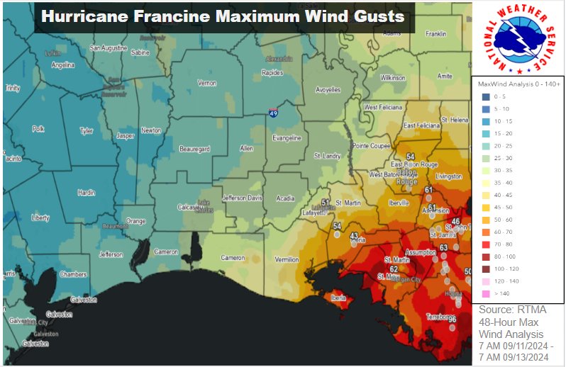
Above: Maximum wind gusts map using data from Real-Time Mesoscale Analysis (RTMA) from 7 AM CDT September 11th to 7 AM CDT September 13th. Graphic created by Marti Calhoun.
WATER LEVELS:
The highest storm surge flooding occurred across lower coastal St. Mary Parish with levels of 2.25 to 2.75 feet MHHW, mainly the morning before and up to the passage of the western eyewall on September 11th. Further west across coastal Iberia, Vermilion & Cameron Parishes, as well as coastal Jefferson County, water levels peaked around 1.75 to 2.25 feet MHHW earlier during the day, with offshore winds across the western side of the hurricane gradually lowering water levels by the afternoon and evening. Minor coastal flooding was noted across portions of Holly Beach and Cameron, and along Highway 82 & 27 in Cameron Parish. For complete water levels reports, see the Water Levels section of the Post Tropical Cyclone Report.
RAINFALL:
The highest rainfall of 8.56 inches was recorded by a USGS gauge at Bayou Millhome at Stephensville, Louisiana. Multi-radar multi-sensor quantitative precipitation estimates 6 to nearly 10 inches of rainfall fell across lower St. Mary Parish (see graphic below). Numerous homes in the Lakeside Community of Morgan City, Louisiana sustained flooding. Another notable band of 3 to 6 inches was estimated across Northeast Rapides and Northern Avoyelles Parishes. For complete storm total rainfall, see the Rainfall section of the Post Tropical Cyclone Report.
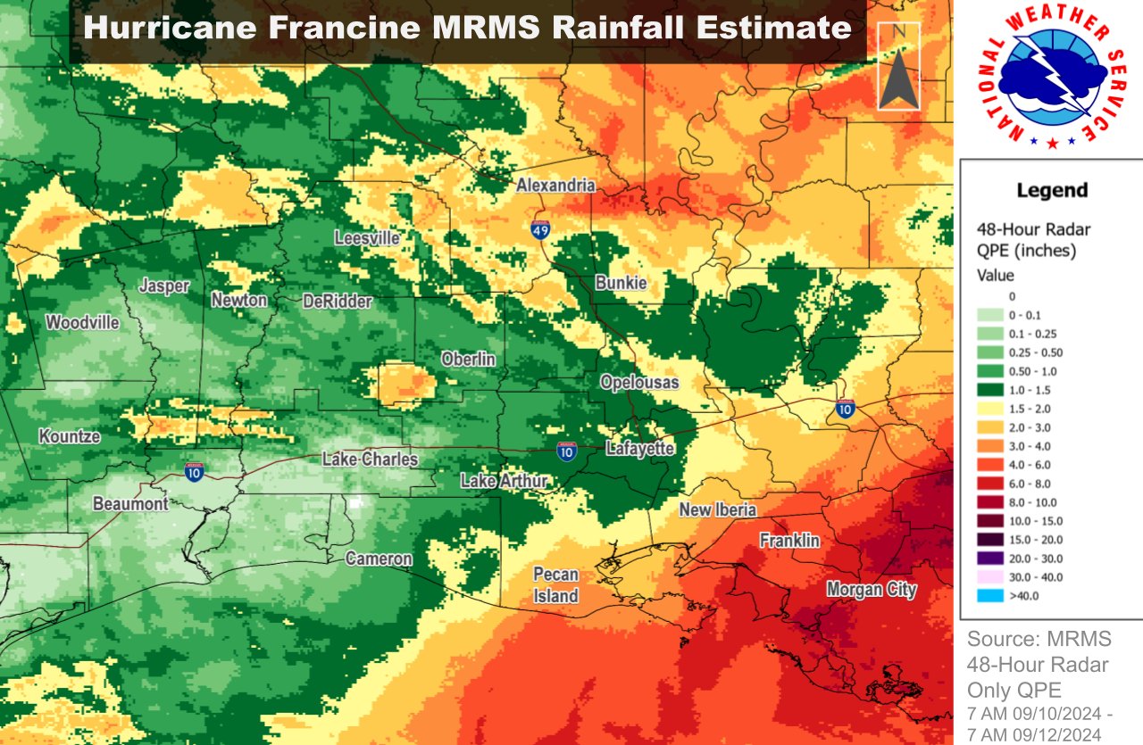
Above: Raw NOAA Multi-radar multi-sensor quantitative precipitation estimation (inches) from 7 AM CDT September 10th to 7 AM CDT September 12th. Graphic created by Marti Calhoun.
TORNADOES:
No tornadoes were reported.
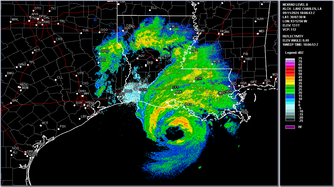
Above: Lake Charles, LA WSR-88D radar image of Hurricane Francine off the South Central Louisiana coast at 1:06 PM CDT September 11, 2024.
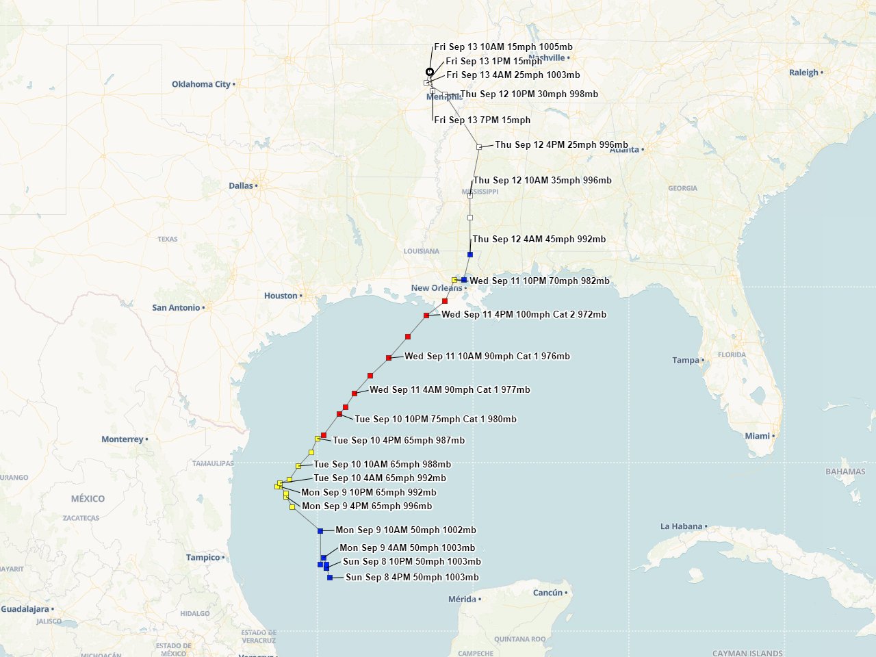
Above: Hurrevac Gulf track of Hurricane Francine from operational National Hurricane Center public advisories.
Webpage design by: Donovan Landreneau
Content by: NWS Lake Charles staff, other sources as noted above.
|

