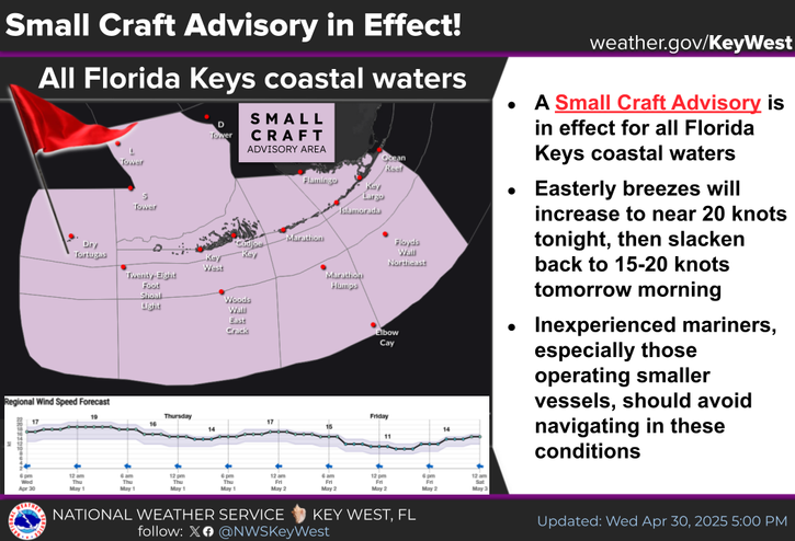
National Weather Service United States Department of Commerce

Coastal Threats for the East and Gulf; Record Warmth for the Central U.S.

Persistent onshore flow across the Southeast and portions of the mid-Atlantic will keep the risk of rip currents through the weekend. Rainfall could be locally heavy across Florida, especially along the eastern shoreline. Meanwhile, record warmth for portions of the Plains and Midwest with elevated fire concerns. For the west, a trough will keep the pattern unsettled with wet conditions. Read More >

A Coastal Flood Advisory remains in effect for the Upper Keys!
A Coastal Flood Statement remains in effect for the Middle and Lower Keys!
For the Advisory: Saltwater flooding of low elevation streets and lots is expected. Some storm drains will overflow, and some seawalls and docks will be overtopped. Boaters can expect less clearance under fixed bridges. Motorists should remember that persistent puddles around the times of high tide are almost certain to contain a mix of saltwater.
For the Statement: Minor saltwater flooding of low elevation streets and lots is likely. Some storm drains will overflow, and some seawalls and docks will be overtopped. Boaters can expect less clearance under fixed bridges. Motorists should remember that persistent puddles around the times of high tide are almost certain to contain a mix of saltwater.
COASTAL FLOOD ADVISORY IS IN EFFECT FOR THE UPPER KEYS!
COASTAL FLOOD STATEMENT IN EFFECT FOR THE MIDDLE AND LOWER KEYS!
UPPER KEYS: TONIGHT... Mostly cloudy with a chance of showers and a slight chance of thunderstorms. Lows in the upper 70s. Northeast to east winds 10 to 15 mph, becoming east to southeast 5 to 10 mph. Chance of rain 50 percent.
MIDDLE AND LOWER KEYS: TONIGHT... Mostly cloudy with a chance of showers and a slight chance of thunderstorms. Lows in the upper 70s. East winds 10 to 15 mph, becoming east to southeast 5 to 10 mph. Chance of rain 50 percent.
TONIGHT... Gentle to moderate breezes (NE-E in Florida Bay, E-SE for Bayside/Gulfside and deep Gulf, E for Hawk Channel and Florida Straits) becoming light to gentle for Florida Bay and Hawk Channel, and becoming gentle for Bayside/Gulfside and Florida Straits. Bay/nearshore waters a light to moderate chop, becoming a light chop for Bayside/Gulfside and smooth to a light chop for Florida Bay and Hawk Channel. Bayside/Gulfside seas 1 to 2 feet. Hawk Channel seas 2 to 3 feet, subsiding to 1 to 2 feet. Deep Gulf seas 2 to 3 feet. Straits seas 2 to 4 feet, except 3 to 5 feet off the Upper Keys due to a north swell. Winds and seas higher in scattered showers and isolated thunderstorms. Higher High Tides: Mariners should expect less clearance under fixed bridges.


Text Product Selector
(Selected product opens in a new window) 


Sunrise & Sunset

Sunrise & Sunset


Moon Rise & Set

Moon Rise & Set


Moon Illumination

Moon Illumination


Tide Information

Tide Information


Tropical

Tropical


Coastal Flooding

Coastal Flooding


Tallship

Marine


Nearshore Waves

Wave Prediction


Thumbnail for a local waterspouts website, showing 4 waterspouts.

Waterspouts


Airplane

Aviation


Key West & Marathon Climographs 2020

Climographs


Tropical

Forecast Discussion


NOAA Weather Radio

NOAA Weather Radio