January 2, 2017 Severe Weather and Tornadoes
Event Summary
As a surface high stayed situated along the mid-Atlantic, the region had a warm front draped across northeast Louisiana into north-central Mississippi. A fast moving upper level disturbance in the southern Plains helped a storm system develop early Monday January 2nd, 2017. Heavy rain from storms early in the morning, some 2+ inches, helped to reinforce the stalled warm frontal boundary, mainly just along and north of I-20 corridor. As the disturbance closed in to the area early-mid morning, a strong surface low and fast moving cold front helped a strong bowing squall line to develop across central Louisiana. This began to race eastward and moved into the region around to just before noon. Just along and south of the warm frontal boundary, sufficient low level moisture and strong wind shear set the stage for the squall line to continue to intensify and maintain intensity as it raced across the ArkLaMiss. By mid-afternoon, around 4PM, this squall line and any prefrontal storms that began to develop across southern Mississippi had mostly moved through the region. The cold front and drier air finally moved through the entire region late evening to near midnight on Tuesday January 3rd, 2017.
The squall line brought widespread damaging winds across most areas south of the Interstate 20 corridor. A total of 8 tornadoes developed along the leading edge of the squall line, all of them occurring south of Interstate 20. 2 EF0s, 5 EF1s and 1 EF2 tornado, a strong tornado, developed across the area. These tornadoes caused widespread damage to trees and powerlines across the area. The EF1 tornado in Lincoln County caused damage to the historic Sweetwater Methodist Church, which was pushed off its foundation and moderate wall damage occurred. Some more structures, including some homes, mobile homes, sheds and chicken houses, sustained more damage in these tornadoes. The most intense damage occurred south of Mount Olive in Covington County. In this area, a strong tornado crossed Highway 49, where the EF2 tornado destroyed a few large chicken houses and received extensive damage. Thankfully, no injuries or fatalities occurred from to the squall line and associated tornadoes that developed along the line.
01/02/17 Tornado Event Track Map
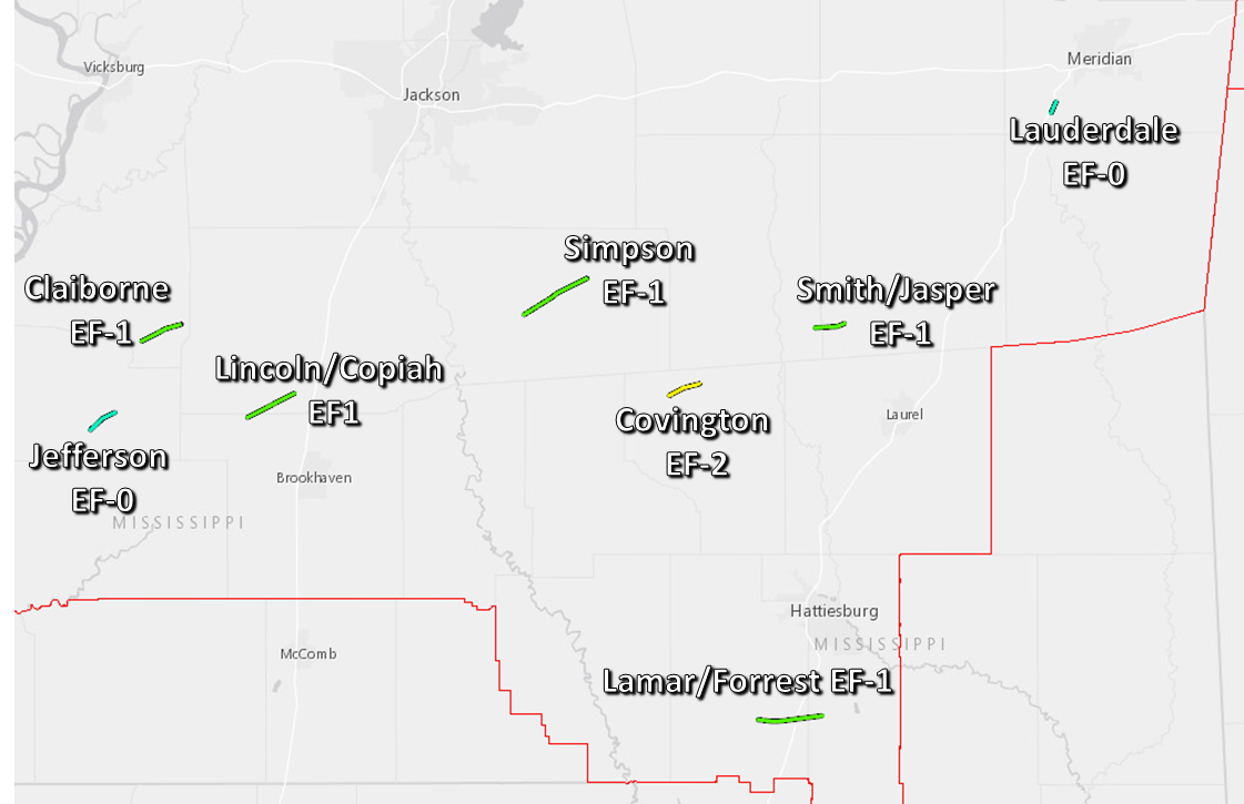
Click on map above to see entire event tracks and damage point notation.
Click on the location in the table for additional maps and details below.
| Location | Start/ End Time |
Event Type | Fatalities/ Injuries |
Path Length | Path Width |
| Jefferson County 7 ENE McNair to 5 SSW Blue Hill |
1:02 PM- 1:05 PM |
EF-0 Tornado 85 mph |
none | 4.0 miles | 250 yards |
| Claiborne County 1 WSW Peyton to 4 ENE Peyton |
1:14 PM- 1:20 PM |
EF-1 Tornado 95 mph |
none | 5.6 miles | 200 yards |
| Lincoln/Copiah County 3 ENE Caseyville, Lincoln Co. to 11 SW Hazlehurst, Copiah Co. |
1:21 PM- 1:28 PM |
EF-1 Tornado 105 mph |
none | 6.8 miles | 300 yards |
| Simpson County 1 WNW Pinola to 2 ESE Mendenhall |
2:02 PM- 2:12 PM |
EF-1 Tornado 110 mph |
none | 9.5 miles | 400 yards |
| Covington County 2 S Mount Olive to 4 E Mount Olive |
2:21 PM- 2:26 PM |
EF-2 Tornado 115 mph |
none |
4.2 miles |
300 yards |
| Smith/Jasper County 4 W Stringer, Smith Co. to Stringer, Jasper Co. |
2:43 PM- 2:47 PM |
EF-1 Tornado 105 mph |
none | 3.9 miles | 275 yards |
| Lamar/Forrest County 3 WSW Purvis, Lamar Co. to 3 N Rock Hill, Forrest Co. |
2:52 PM- 2:59 PM |
EF-1 Tornado 105 mph |
none | 8.4 miles | 225 yards |
| Lauderdale County 6 N Enterprise to 7 S Nellieburg |
3:28 PM- 3:29 PM |
EF-0 Tornado 75 mph |
none | 1.5 miles | 75 yards |
Central Jefferson EF-0 Tornado
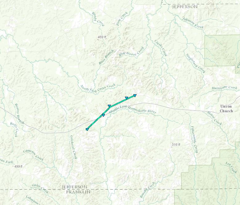
Click on map above to see entire damage point notation and damage pictures at select points.
|
Track Summary |
|
Radar Imagery
These images from the Brandon, MS Doppler radar show the storm at 12:59 pm as the storm passed near Harriston. The image on the left shows 0.5° base reflectivity data, and the image on the right shows 0.5° storm relative velocity data. Click on the thumbnail below for a higher resolution image.

Southeast Claiborne County EF-1 Tornado
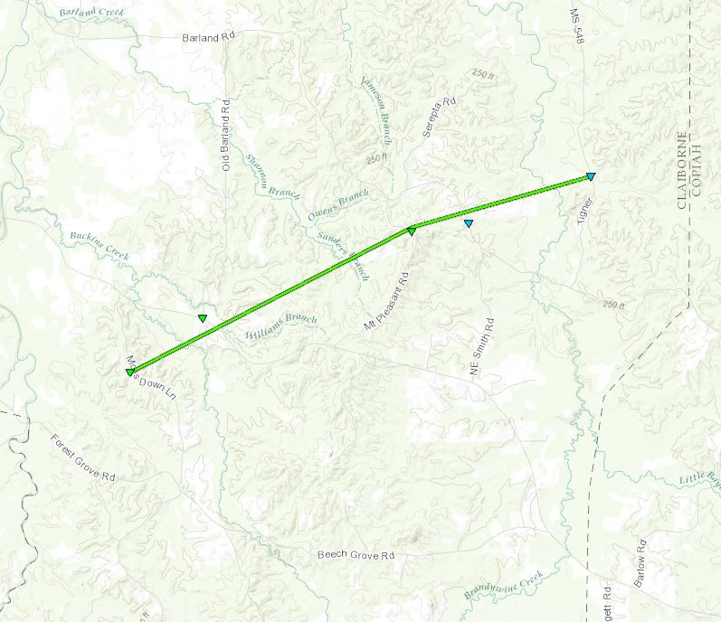
Click on map above to see entire damage point notation and damage pictures at select points.
|
Track Summary |
|
Radar Imagery
These images from the Brandon, MS Doppler radar show the storm at 1:14 pm as the tornado touched down near Peyton. The image on the left shows 0.5° base reflectivity data, and the image on the right shows 0.5° storm relative velocity data. Click on the thumbnail below for a higher resolution image.

Lincoln/Copiah County EF-1 Tornado

Click on map above to see entire damage point notation and damage pictures at select points.
|
Event Summary |
|
Radar Imagery
These images from the Brandon, MS Doppler radar show the storm at 1:22 pm as the tornado crossed the county line. The image on the left shows 0.5° base reflectivity data, and the image on the right shows 0.5° storm relative velocity data. Click on the thumbnail below for a higher resolution image.


Click on map above to see entire damage point notation and damage pictures at select points.
|
Event Summary |
|
Radar Imagery
These images from the Brandon, MS Doppler radar show the storm at 2:07 pm as the tornado occurred near Highway 43. The image on the left shows 0.5° base reflectivity data, and the image on the right shows 0.5° storm relative velocity data. Click on the thumbnail below for a higher resolution image.


Click on map above to see entire damage point notation and damage pictures at select points.
|
Event Summary |
|
Radar Imagery
These images from the Brandon, MS Doppler radar show the storm around 2:21 pm as the tornado touched down near Mt. Olive in northern Covington County. The image on the left shows 0.5° base reflectivity data, and the image on the right shows 0.5° storm relative velocity data. Click on the thumbnail below for a higher resolution image.

Smith/Jasper County EF-1 Tornado
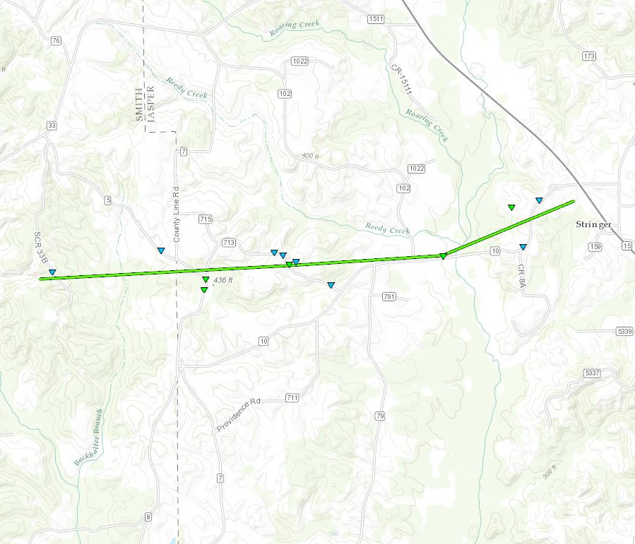
Click on map above to see entire damage point notation and damage pictures at select points.
|
Event Summary |
|
Radar Imagery
These images from the Brandon, MS Doppler radar show the storm around 2:43 pm as the tornado occurred near Stringer in southeast Smith County. The image on the left shows 0.5° base reflectivity data, and the image on the right shows 0.5° storm relative velocity data. Click on the thumbnail below for a higher resolution image.

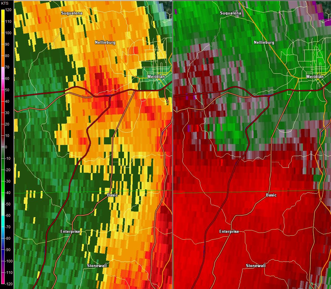
Southeast Lamar/West Forrest County EF-1 Tornado
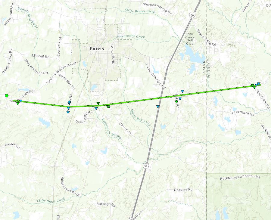
Click on map above to see entire damage point notation and damage pictures at select points.
|
Event Summary |
|
Radar Imagery
These images from the Slidell, LA Doppler radar show the storm at 2:56 pm as the tornado occurred near Purvis. The image on the left shows 0.5° base reflectivity data, and the image on the right shows 0.5° storm relative velocity data. Click on the thumbnail below for a higher resolution image.

Lauderdale County EF-0 Tornado

Click on map above to see entire damage point notation and damage pictures at select points.
|
Event Summary |
|
Radar Imagery
These images from the Brandon, MS Doppler radar show the storm at 3:28 pm as the tornado occurred southwest of Meridian. The image on the left shows 0.5° base reflectivity data, and the image on the right shows 0.5° storm relative velocity data. Click on the thumbnail below for a higher resolution image.
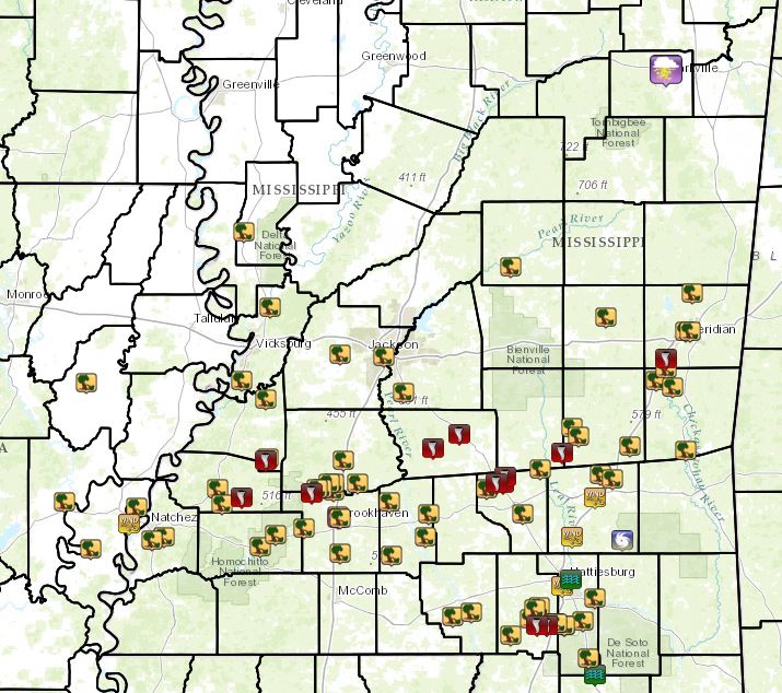
Local Storm Reports
Click on the map for additional details.


 Follow us on YouTube