March 30 & 31, 2016 Tornadoes
Event Summary
Widespread severe weather and some flash flooding occurred over the ArkLaMiss region from the evening of March 30th through the evening of March 31st. On March 30th an upper level storm system moved into the region from the Southern Plains. It was accompanied by a slow moving cold front extending from a large surface low across the Central Plains into the middle Mississippi Valley.
A warm moisture rich air mass from the Gulf of Mexico moved into the region as a warm front lifted northward on the 30th. A series of potent upper level disturbances crossed the region through the 31st, bringing a rapid increase in wind aloft and resulting in an unstable environment that contained high levels of wind shear. These factors set the stage for flash flooding and several rounds of severe weather. Widespread severe weather occurred with a mix damaging winds, up to golf ball sized hail, and four tornadoes. Two EF-1 Tornadoes occurred in Chicot County, one of which resulted in an injury. Other EF-1 tornadoes occurred in Lamar and Lowndes counties. Parts of the Delta region experienced flash flooding, especially in Washington, Sunflower, Leflore, Carroll, and Montgomery counties. Fifteen homes had to be evacuated at Moorhead in Sunflower County. There were flooding issues on many primary and secondary roads. There was also additional river flooding from this system.
The cold front moved across the region on Thursday night ending the severe weather from the northwest.
Tornado Event Track Map

Click on map above to see entire event tracks and damage point notation.
Click on the location in the table for additional maps and details below.
3/30 Dermott (South) EF-1 Tornado
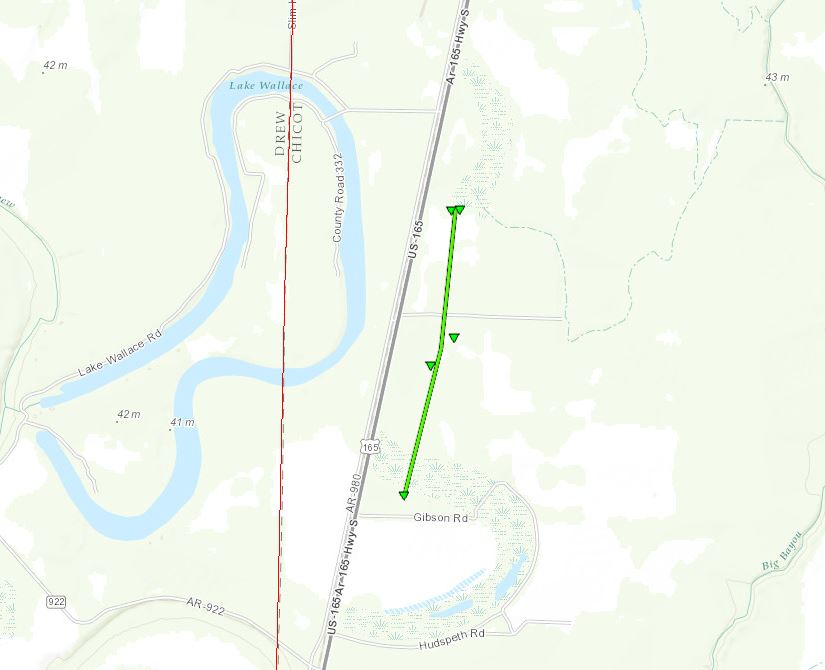
Click on map above to see entire damage point notation and damage pictures at select points.
|
Event Summary
This tornado began just east of US Highway 165 and north of Gibson Rd where a 120 ft tall radio antenna was blown over. The tornado continued north paralleling Highway 165. The tornado reached its strongest point just south of Bullock Rd, where a diesel tank was moved several yards through a sod farm and an irrigation pivot was overturned. The tornado lifted about a half mile north of Bullock Rd damaging a few power poles and snapping a tree along a driveway.
|
Rating:
(Click for EF Scale) |
EF-1 |
| Estimated Maximum Wind: |
100 mph |
| Fatalities/Injuries: |
none |
| Damage Path Length: |
1.5 miles |
| Maximum Path Width: |
100 yards |
| Approximate Start Point/Time: |
5 S Dermott
11:11 pm
|
| Approximate End Point/Time: |
4 S Dermott
11:12 pm
|
|
Back to the table
3/30 Dermott (Downtown) EF-1 Tornado
Click on map above to see entire damage point notation and damage pictures at select points.
|
Event Summary
The entire path of this tornado was within a mile of the path of the tornado which occurred on the evening of March 13th. The tornado began on the west side of Dermott just south of W Gaines St, where much of the roof was removed from a home and the carport was blown away. An outbuilding was damaged at this location as well and a pontoon boat was blown several yards. The tornado continued through the center of Dermott intermittently snapping and uprooting trees and breaking a couple utility poles along the path. Minor roof damage occurred at a senior care facility, an abandoned trailer was damaged, and a fence was blown down. On the east side of down, a light pole was blown over at a baseball field and a small billboard was blown over. As the tornado crossed the intersection of AR Highway 35 and US Highway 165, several construction cones were blown away. The tornado reached its strongest point in a field north of Highway 35, where a farm equipment shed was demolished. Heavy foundation blocks and farm trailers were moved. Debris was scattered at least a half mile to the north through fields and across US Highway 165. The tornado lifted shortly thereafter.
|
Rating:
(Click for EF Scale) |
EF-1 |
| Estimated Maximum Wind: |
110 mph |
| Fatalities/Injuries: |
1 injury |
| Damage Path Length: |
3.7 miles |
| Maximum Path Width: |
150 yards |
| Approximate Start Point/Time: |
1 SW Dermott
11:15 pm
|
| Approximate End Point/Time: |
3 ENE Dermott
11:19 pm
|
|
Back to the table
3/31 Lamar County EF-1 Tornado
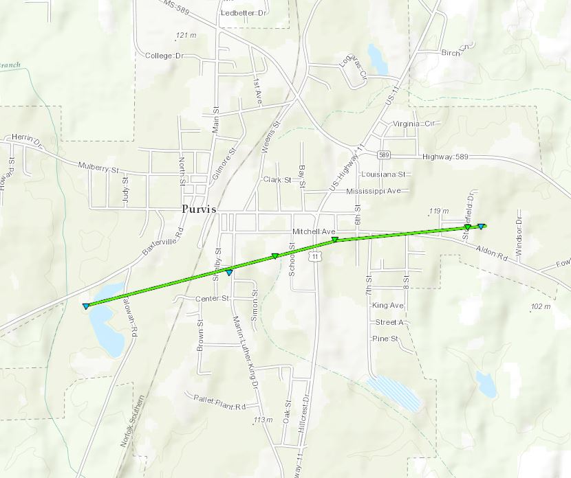
Click on map above to see entire damage point notation and damage pictures at select points.
|
Event Summary
This tornado touched down near Talowah Rd where it uprooted a couple of trees and caused some minor roof damage to a home. The tornado continued east northeast uprooting a few trees and causing roof damage to an elementary school. The tornado continued east northeast across Mitchell Ave where a tree fell on a house. The tornado ended near Stonefield Drive snapping a few more trees and causing roof damage to a home.
|
Rating:
(Click for EF Scale) |
EF-1 |
| Estimated Maximum Wind: |
95 mph |
| Fatalities/Injuries: |
none |
| Damage Path Length: |
1.5 miles |
| Maximum Path Width: |
50 yards |
| Approximate Start Point/Time: |
1 WSW Purvis
7:53 am
|
| Approximate End Point/Time: |
1 E Purvis
7:55 am
|
|
Back to the table
3/31 Lowndes EF-1 Tornado
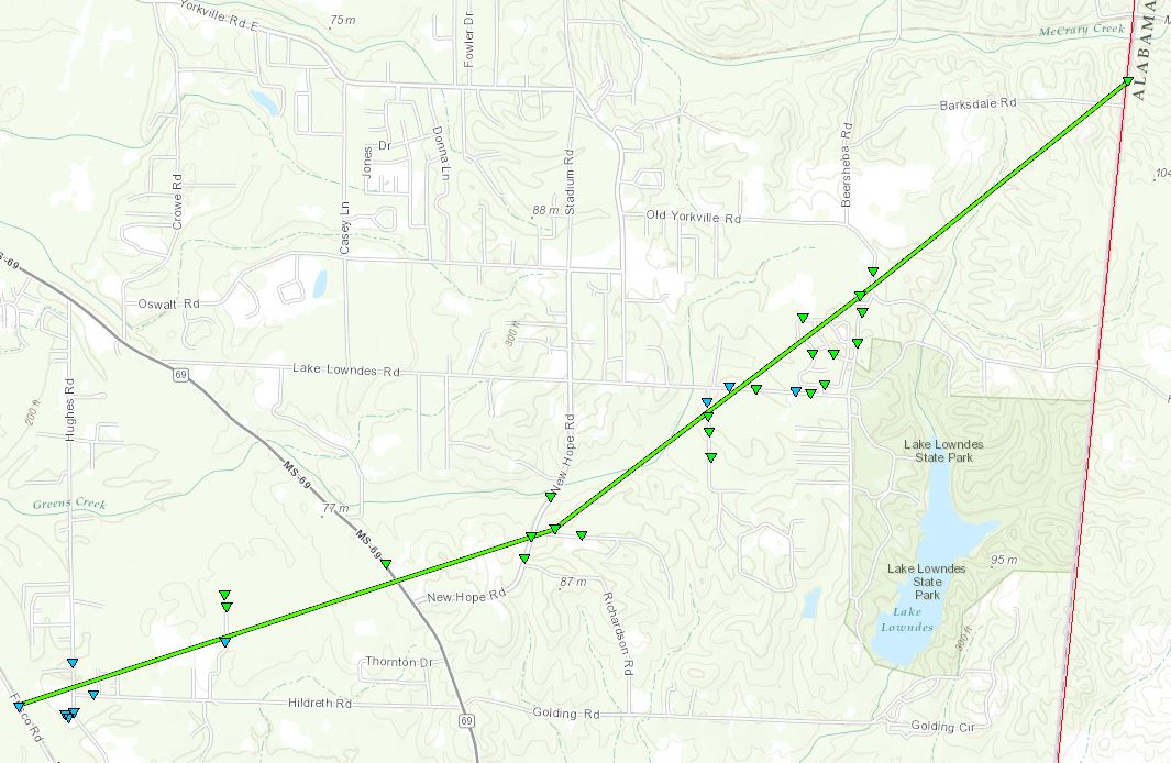
Click on map above to see entire damage point notation and damage pictures at select points.
|
Event Summary
This tornado began southeast of Columbus on Frisco Road. Here there were a few trees snapped and limb debris. The tornado continued northeast crossing Hughes Road and Hildreth Road, snapping and downing trees along the path. As it crossed Hughes Road, it peeled back the roof of a shed. The tornado began to get wider as it moved across Hildreth Road. The tornado continued through a wooded area north of Hildreth Road until crossing Bryant Road. Here a fence was blown down and higher damage occurred at the dead end. Many trees were blown down along the end of the road and shingle damaged occurred to a few homes. Large trees were downed off to the north of the road in the wooded area. It began to show signs of becoming a multiple vortex tornado, as there seemed to be two distinct corridors of damage. The tornado continued northeast before crossing Highway 69 where many trees were snapped, bringing down a powerline and snapping a powerpole. The tornado continued northeast before crossing New Hope Road and Petersburg Road. Along in this area the tornado was very wide, over a quarter mile, and caused numerous trees to be downed. A few trees were on homes, especially along Petersburg Road, where numerous homes had shingle damage, a tree fell on a home and minor damage occurred to a shed. The tornado continued northeast before crossing Pritchard Lane, continuing to show signs of a multi-vortex tornado. Numerous trees were downed along the road and minor roof damage occurred to a shed. The tornado then crossed Lake Lowndes Road where many trees were snapped and a few powerlines were blown down. It was in this area and crossing into the Lakeover subdivision on Lakeover Drive where the highest damage occurred with high end EF1 damage with winds reaching around 110 mph. Numerous trees were blown down, with some falling into homes, and numerous had shingle damage. The tornado continued northeast, crossing Lake Lowndes Road and Ernest Drive. Many large trees were blown down and roof was peeled back on a shed on Ernest Drive. The tornado crossed Old Yorkville Road, continuing to take down numerous trees along the path and taking down a powerpole. The tornado then crossed into an open field before moving into a wooded area. The tornado continued before crossing State Line Road at the Mississippi-Alabama border, where a powerpole was snapped and numerous trees were uprooted. The tornado began to turn more to the north-northeast after crossing the state line into Alabama and crossed Robin Road, where multiple trees were downed, blocking the railroad tracks. It continued north-northeast and crossed Eagle Road, where numerous trees were uprooted and snapped. The tornado continued across County Road 30 and Pine Wood Circle, snapping and uprooting many trees. The tornado dissipated just after crossing Highway 82.
|
Rating:
(Click for EF Scale) |
EF-1 |
| Estimated Maximum Wind: |
110 mph |
| Fatalities/Injuries: |
none |
| Damage Path Length: |
5.8 miles (7.9 miles total) |
| Maximum Path Width: |
600 yards |
| Approximate Start Point/Time: |
3 SW New Hope
6:18 pm
|
| Approximate End Point/Time: |
3 ENE New Hope (continued to near US 82/Eagle Rd)
6:33 pm (in MS)
|
|
Back to the table
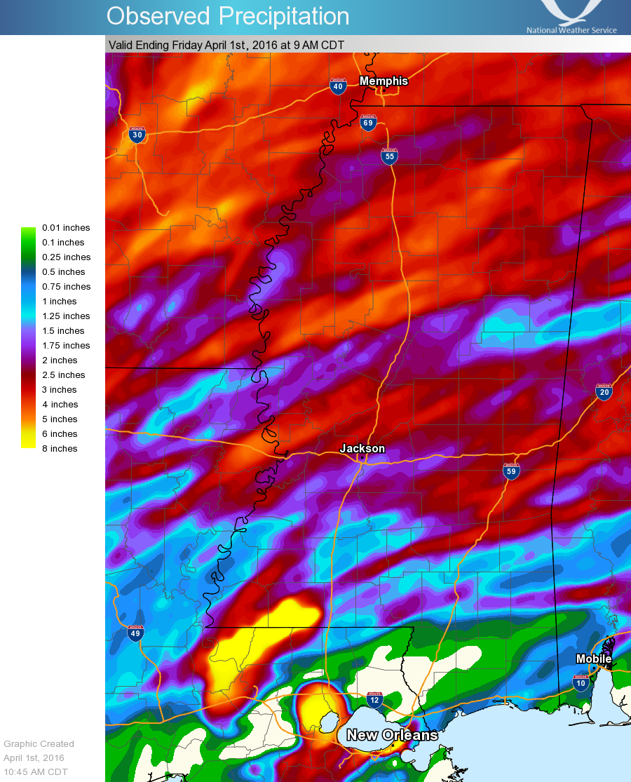
Precipitation Summary
Back to the top
Local Storm Reports
Click on the map below for additional details.


Back to the top


 Follow us on YouTube