February 15, 2016 Tornadoes
Event Summary
Widespread severe weather occurred on Monday with a mix of damaging winds, hail and several tornadoes. The focus of the severe weather was across Central and Southern Mississippi. The hardest hit areas were across Copiah, Simpson, Smith, and Jasper Counties where the main axis of tornadoes occurred. Other tornadoes occurred in Hinds, Leake and Winston Counties as well. A microburst also downed numerous trees and destroyed a mobile home along the Lincoln/Copiah County line. This event was driven by a potent disturbance that swung across the area during the midday and afternoon hours. As this strong feature dropped into the Lower Mississippi River Valley, a surface low rapidly deepened as it tracked across Central Mississippi. The atmospheric response to this was for a rapid increase in winds aloft and higher low level moisture. This combination set the stage for an unstable environment that contained high levels of wind shear which supported and sustained tornado development.
Tornado Event Track Map

Click on map above to see entire event tracks and damage point notation.
Click on the location in the table for additional maps and details below.
Hinds EF-0 Tornado
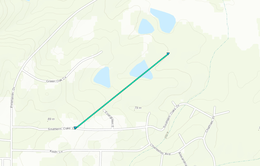
Click on map above to see entire damage point notation and damage pictures at select points.
|
Event Summary
This weak and brief tornado touched down in the Southern Oaks subdivision just off Pinehaven Drive. A few cedar trees were snapped and the top of one hardwood tree was blown off. Additional large limbs were broken. The tornado continued to the northeast into a wooded area before lifting. A brief tornadic debris signature (TDS) was observed as well.
|
Rating:
(Click for EF Scale) |
EF-0 |
| Estimated Maximum Wind: |
75 mph |
| Fatalities/Injuries: |
none |
| Damage Path Length: |
0.5 miles |
| Maximum Path Width: |
50 yards |
| Approximate Start Point/Time: |
3 NNE Clinton
11:00 am
|
| Approximate End Point/Time: |
3 NNE Clinton
11:01 am
|
|
Back to the table
Copiah/Simpson EF-2 Tornado
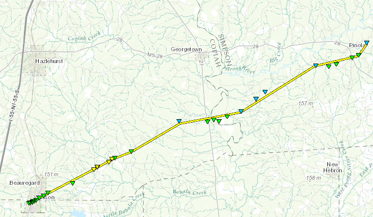
Click on map above to see entire damage point notation and damage pictures at select points.
|
Event Summary
The tornado began along Highway 51 just southwest of Wesson. As it tracked northeast, it snapped many hardwood trees. It also caused roof damage to Wesson Attendance Center as well as downing trees that fell on employee cars. As the tornado continued across the southern end of Beauregard, it continued to down trees with one falling on a house. Another house had minor roof damage. As the tornado passed south-southeast of Sand Hill, it became more intense with numerous trees snapped along Beauregard Road. The worst damage occurred on Sand Hill Road, where a home was obliterated. This is where the tornado reached its most intense point and winds reached 130 mph. Another home suffered significant roof damage, a shop was destroyed and many trees were blown down. The tornado tracked northeast, downing numerous trees and causing roof damage to a mobile home on Beauregard Road. The tornado then weakened slightly as it tracked into Simpson County and caused roof damage to two homes on Rockport Road. EF1 type damage was found in the Rockport area, which included snapped trees and some minor roof damage along Highway 27, Camp Lane, and Lower Rockport Road.Minor tree damage occurred as the tornado tracked south of Bridgeport. It reintensified near Bushtown Shivers Road and snapped and uprooted softwood trees as it tracked across Highway 28 south of Pinola. The tornado finally lifted near Tom Coke Road on the eastern side of Pinola.
|
Rating:
(Click for EF Scale) |
EF-2 |
| Estimated Maximum Wind: |
130 mph |
| Fatalities/Injuries: |
none |
| Damage Path Length: |
30.8 miles |
| Maximum Path Width: |
250 yards |
| Approximate Start Point/Time: |
SW Wesson
12:10 pm
|
| Approximate End Point/Time: |
2 ENE Pinola
12:57 pm
|
|
Back to the table
Leake EF-1 Tornado
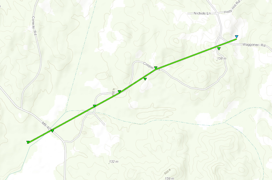
Click on map above to see entire damage point notation and damage pictures at select points.
|
Event Summary
The tornado began just to the west of Highway 429, snapping some trees near Koli Creek. The tornado then tracked northeast along Cooper Road. In this area, it caused heavy tree damage along the path, snapping or uprooting numerous trees. Also along this road, three chicken houses were flattened and another was damaged. A home suffered minor roof damage. The tornado crossed Waggoner Road and lifted in an adjacent wooded area.
|
Rating:
(Click for EF Scale) |
EF-1 |
| Estimated Maximum Wind: |
110 mph |
| Fatalities/Injuries: |
none |
| Damage Path Length: |
1.9 miles |
| Maximum Path Width: |
300 yards |
| Approximate Start Point/Time: |
5 SE Thomastown
12:15 pm
|
| Approximate End Point/Time: |
5 SSW Singleton
12:19 pm
|
|
Back to the table
Winston EF-1 Tornado
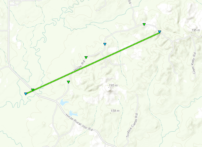
Click on map above to see entire damage point notation and damage pictures at select points.
|
Event Summary
The tornado began west of Hinze-Rural Hill Road near Lobutcha Creek. It snapped several softwood trees and uprooted a few hardwood trees. The tornado then tracked along Hinze Road where it continued to cause tree damage before lifting.
|
Rating:
(Click for EF Scale) |
EF-1 |
| Estimated Maximum Wind: |
105 mph |
| Fatalities/Injuries: |
none |
| Damage Path Length: |
2.5 miles |
| Maximum Path Width: |
200 yards |
| Approximate Start Point/Time: |
7 NE Zama
12:45 pm
|
| Approximate End Point/Time: |
10 ENE Zama
12:50 pm
|
|
Back to the table
Lincoln/Copiah Straight-Line Wind Damage

Click on map above to see entire damage point notation and damage pictures at select points.
|
Event Summary
An intense microburst occurred along the Lincoln/Copiah County line. Damage occurred just west of Jackson-Liberty Road and N of Norton-Assink Road. Here a mobile home was rolled multiple times and destroyed. A couple minor injuries occurred at this location. Other damage that was noted was many uprooted trees along nearly a 3 mile swath. All of the uprooted trees were blown down to the east-northeast. Along Old Red Star Road, the roof of a metal shed was blown off and tin was blown into a tree along with some tin peeled off the corner of a roof of another home. The width of this damage was nearly 1 mile wide with max winds around 95 mph. The damage ended near Foster Lane near the county line.
|
Rating:
(Click for EF Scale) |
N/A |
| Estimated Maximum Wind: |
95 mph |
| Fatalities/Injuries: |
Injuries: 2 |
| Damage Path Length: |
3.3 miles |
| Maximum Path Width: |
1600 yards |
| Approximate Start Point/Time: |
5 NNW Loyd Star
1:18 pm
|
| Approximate End Point/Time: |
6 NNE Loyd Star
1:23 pm
|
|
Back to the table
Smith EF-0 Tornado

Click on map above to see entire damage point notation and damage pictures at select points.
|
Event Summary
This brief tornado touched down on Smith County Road 114 in western Smith County. It crossed Georgia Pacific Land and ended back on County Road 114 near Clear Creek. A few trees were downed along the path.
|
Rating:
(Click for EF Scale) |
EF-0 |
| Estimated Maximum Wind: |
75 mph |
| Fatalities/Injuries: |
none |
| Damage Path Length: |
2.1 miles |
| Maximum Path Width: |
100 yards |
| Approximate Start Point/Time: |
8 NE Magee
1:24 pm
|
| Approximate End Point/Time: |
10 NE Magee
1:27 pm
|
|
Back to the table
Sylvarena EF-1 Tornado

Click on map above to see entire damage point notation and damage pictures at select points.
|
Event Summary
The tornado began near Smith County Road 84, where some softwood trees were uprooted. It then tracked northeast into Sylvarena. Here the tornado damaged several structures along Highway 18, including ripping off a gas station canopy and blowing down an antenna. Homes also had roof damage and were damaged by uprooted trees. The tornado continued northeast and lifted amongst some trees south of Ted-Sylvarena Road.
|
Rating:
(Click for EF Scale) |
EF-1 |
| Estimated Maximum Wind: |
105 mph |
| Fatalities/Injuries: |
none |
| Damage Path Length: |
2.7 miles |
| Maximum Path Width: |
250 yards |
| Approximate Start Point/Time: |
2 SW Sylvarena
1:43 pm
|
| Approximate End Point/Time: |
6 WNW Bay Springs
1:47 pm
|
|
Back to the table
Smith/Jasper EF-1 Tornado
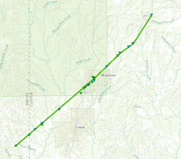
Click on map above to see entire damage point notation and damage pictures at select points.
|
Event Summary
The tornado began just west of Smith County Road 107 where it snapped some trees. It then crossed into Jasper County, continuing to uproot and snap trees. The tornado entered Montrose where numerous trees were either snapped or uprooted. There was also damage to several buildings in Montrose, including roof damage to a church as well as damage to houses due to fallen trees. The tornado was at its widest point in Montrose. The tornado continued northeast, following Highway 15. Here it snapped and uprooted trees through the remainder of its path, with a few falling on homes. The tornado lifted just north of the Highway 15 intersection with Jasper County Road 24.
|
Rating:
(Click for EF Scale) |
EF-1 |
| Estimated Maximum Wind: |
110 mph |
| Fatalities/Injuries: |
none |
| Damage Path Length: |
14.7 miles |
| Maximum Path Width: |
350 yards |
| Approximate Start Point/Time: |
3 NE Sylvarena
1:52 pm
|
| Approximate End Point/Time: |
3 SW Garlandville
2:11 pm
|
|
Back to the table
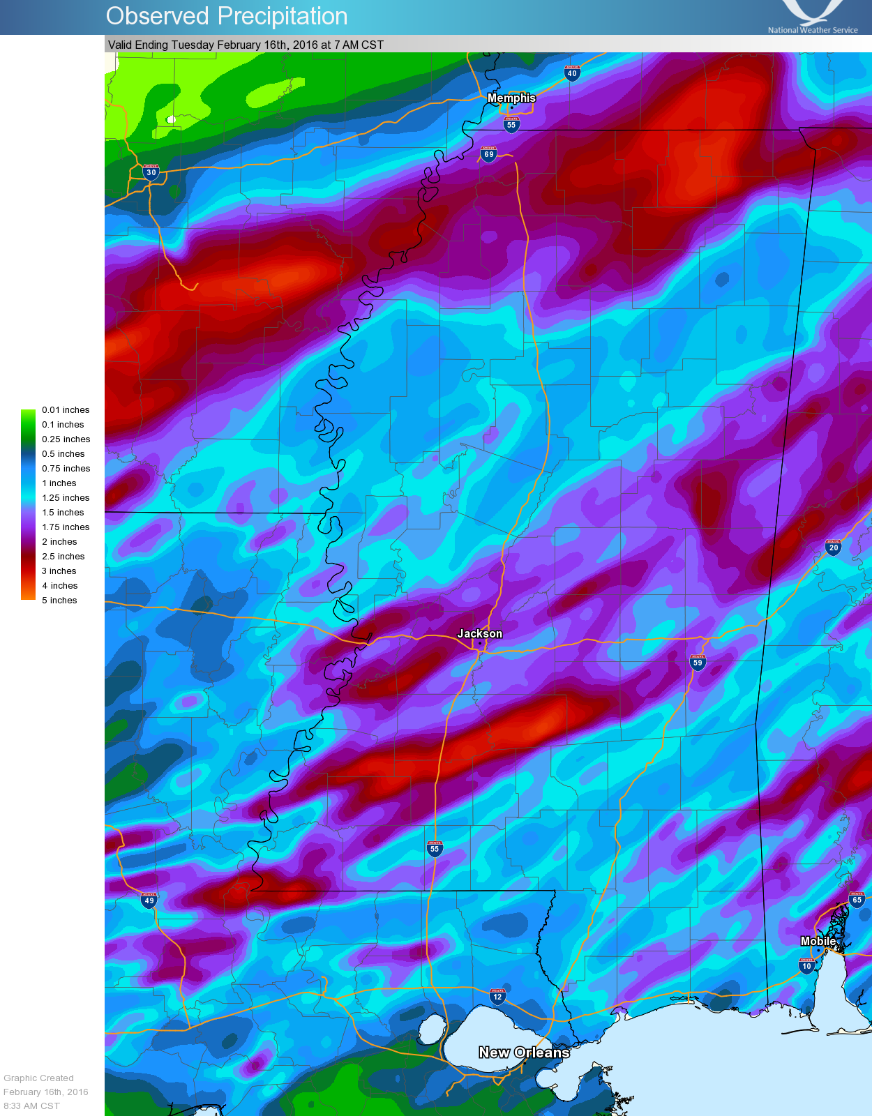
Precipitation Summary
Back to the top
Local Storm Reports
Click on the map below for additional details.


Back to the top


 Follow us on YouTube