February 2, 2016 Tornadoes
Event Summary
A spring like weather system took shape on Feb 2 and set the stage for a round of severe storms with tornadoes. A large surface low developed across the Eastern Plains and Midwest with an attendant surface front that extended southward into the ArkLaMiss region. While the core of the best lift was over the Midwest, a combination of sufficient lift along with strong wind shear and instability coexisted across portions of East-Central Mississippi. Several supercell thunderstorms developed during the afternoon with a few producing tornadoes. One cell in particular was efficient at producing tornadoes and produced 3 before moving into Alabama where it produced a few more. This cell impacted Newton, Lauderdale, Kemper, and Noxubee Counties with tornadoes, 2 of which were strong and rated EF2.
Tornado Event Track Map

Click on map above to see entire event tracks and damage point notation.
Click on the location in the table for additional maps and details below.
Newton County EF-1 Tornado

Click on map above to see entire damage point notation and damage pictures at select points.
|
Event Summary
This tornado touched down just west of Highway 15 and tracked northeast across Highway 15 and Highway 504 damaging two homes and a mobile home. The tornado continued northeast across Shelby Road and Garvin Road, damaging the roof of a home and destroying two chicken houses. The most intense damage along the path was to the chicken houses. Numerous trees and power poles were snapped throughout its path before it dissipated near Brand Road.
|
Rating:
(Click for EF Scale) |
EF-1 |
| Estimated Maximum Wind: |
110 mph |
| Fatalities/Injuries: |
none |
| Damage Path Length: |
7.5 miles |
| Maximum Path Width: |
150 yards |
| Approximate Start Point/Time: |
5 S Newton
2:48 pm
|
| Approximate End Point/Time: |
2 WSW Hickory
2:52 pm
|
|
Back to the table
Lauderdale/Kemper County EF-2 Tornado

Click on map above to see entire damage point notation and damage pictures at select points.
|
Event Summary
The tornado began southwest of Collinsville near Honeysuckle Drive. It caused damage to numerous homes in this subdivision, mainly to roofs. The tornado then tracked northeast through other subdivisions along Magnolia Road, again causing roof damage that ranged from minor shingle damage to roofs completely destroyed. The tornado also caused extensive damage to a mobile home along Magnolia Drive. As the tornado crossed Highway 494, it caused additional roof damage to a home as well as lifting a mobile home. As the tornado crossed a subdivision along Collinsville Circle, it caused additional roof damage with some extensive. As the tornado tracked near Highway 19, it caused extensive damage to the several buildings of Collinsville Baptist Church. It was here at the church, as well as several of the homes and the mobile home in the subdivisions southwest of Collinsville that saw the most intense damage and where the tornado was strongest. The tornado continued northeast and snapped or uprooted numerous trees. Minor fence and roof damage occurred at West Lauderdale High School. The tornado continued northeast crossing into Kemper County, mainly snapping or uprooting softwood and hardwood trees before it dissipated past Kipling Road.
|
Rating:
(Click for EF Scale) |
EF-2 |
| Estimated Maximum Wind: |
125 mph |
| Fatalities/Injuries: |
none |
| Damage Path Length: |
21.4 miles |
| Maximum Path Width: |
0.5 miles |
| Approximate Start Point/Time: |
3 SW Collinsville
3:19 pm
|
| Approximate End Point/Time: |
4 S De Kalb
3:49 pm
|
|
Back to the table
Kemper/Noxubee EF-2 Tornado

Click on map above to see entire damage point notation and damage pictures at select points.
|
Event Summary
This tornado touched down and crossed Graham Road and downed several trees. The tornado then tracked through a wooded area and crossed Highway 16 on the west side of Scooba. Here more trees were snapped or uprooted along with a few power poles that were pushed over. The tornado impacted the west side of Scooba and the western part of East Mississippi Community College. Here the baseball field fence was torn down along with some of the field buildings damaged. Two mobile buildings were heavily damaged in this area. Numerous trees were damaged along with a couple homes with minor roof damage. The tornado then crossed Highway 45 where more trees were snapped. The tornado reached its peak intensity as it approached and crossed Old Highway 45 Road. Dozens of trees were snapped or uprooted along the path and one well-built barn was totally destroyed. There was also a grove of pine trees that sustained extensive damage where roughly 85% were snapped leaving very little standing. At this location, there was evidence of multiple vortices. The tornado continued to the northeast and crossed Millington Road, heavily damaging trees. At the end of Mosley Road, a home sustained some minor roof damage. Here an exterior wood built carport was totally destroyed along with a sizeable metal shed. The tornado damaged a few other metal sheds here along with damaging more trees as it moved into a wooded area. The tornado continued moving through the wooded area in far northern Kemper County and then tracked into southeast Noxubee County. Tree damage was noted at the end of White Horse Road. The tornado dissipated in the wooded area in the Noxubee river bottom.
|
Rating:
(Click for EF Scale) |
EF-2 |
| Estimated Maximum Wind: |
115 mph |
| Fatalities/Injuries: |
none |
| Damage Path Length: |
18.5 miles |
| Maximum Path Width: |
300 yards |
| Approximate Start Point/Time: |
4 N Oak Grove
3:53 pm
|
| Approximate End Point/Time: |
3 SSW Cooksville
4:23 pm
|
|
Back to the table
Noxubee EF-1 Tornado
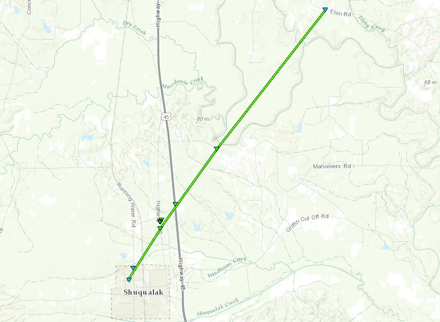
Click on map above to see entire damage point notation and damage pictures at select points.
|
Event Summary
This tornado started in town and was on the weak side as a few trees were uprooted and some limbs broken. More trees were snapped as it crossed the rail road tracks and it peaked in intensity as it crossed Highway 145. Here along Highway 145, numerous trees were snapped and uprooted. A brick gas station had a large portion of the roof lifted off. The old elementary school building was damaged as roughly a 60 foot section of roof was taken off. Many windows were blown out as well. The tornado continued northeast and crossed Highway 45, snapping more trees. More trees were downed at the end of Card Cemetery Road. Some minor tree damage was noted at Elon Road where the tornado dissipated.
|
Rating:
(Click for EF Scale) |
EF-1 |
| Estimated Maximum Wind: |
110 mph |
| Fatalities/Injuries: |
none |
| Damage Path Length: |
6.5 miles |
| Maximum Path Width: |
150 yards |
| Approximate Start Point/Time: |
Shuqualak
5:27 pm
|
| Approximate End Point/Time: |
5 SE Macon
5:36 pm
|
|
Back to the table
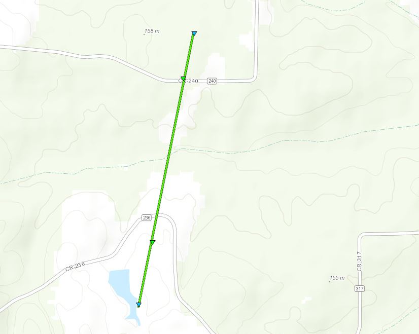
Neshoba EF-1 Tornado
Click on map above to see entire damage point notation and damage pictures at select points.
|
Event Summary
This tornado started just south of County Road 236 where it tore the tin roof off of a home and destroyed an outbuilding. A few hardwood trees were also snapped at this location. The tornado continued northeast to County Road 240 where it uprooted a hardwood tree and also snapped a few softwood trees. The tornado ended just north of County Road 240 snapping a few more trees along the way.
|
Rating:
(Click for EF Scale) |
EF-1 |
| Estimated Maximum Wind: |
105 mph |
| Fatalities/Injuries: |
none |
| Damage Path Length: |
0.7 miles |
| Maximum Path Width: |
50 yards |
| Approximate Start Point/Time: |
1 SW Neshoba
6:39 pm
|
| Approximate End Point/Time: |
1 WSW Neshoba
6:41 pm
|
|
Back to the table
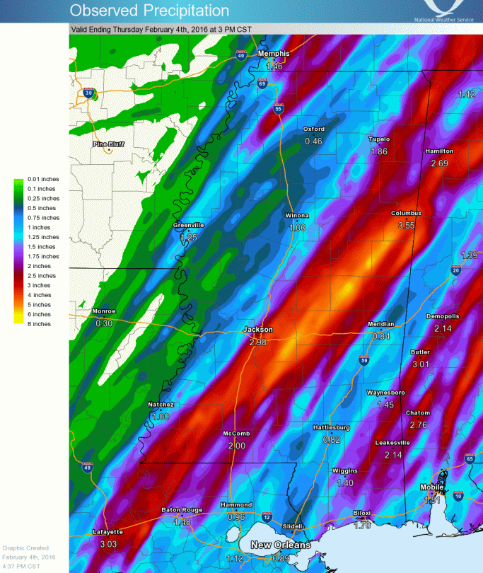
Precipitation Summary
Back to the top
Local Storm Reports
Click on the map below for additional details.


Back to the top


 Follow us on YouTube