With only a little over a week since the previous heavy snowfall event on February 25th, the region again saw another winter weather maker. Luckily for most of the area, the region had begun a warmup that helped alleviate a lot of road issues. After cold high pressure had moved just to the north of the region around March 2nd, a warm front surged north, bringing moisture and much warmer temperatures back into the region. Temperatures warmed quickly on March 4th into the low to mid 70s but a change was in store. A cold front moved quickly to the southeast due to a very cold and strong high pressure building through southern Canada and northern Plains towards our region. Temperatures quickly plummeted some nearly 30-35 degrees in the wake of the cold front.
As the cold front quickly moved southeast, colder air continued to filter in. However, moisture lingered behind the front. Rain began to change over to sleet late the night of March 4th into early morning hours of March 5th. As colder air in the lower parts of the atmosphere continued to filter in, moisture began to transition over to a wintry mix, mainly in the form of sleet, in the northwest Delta. This setup was very favorable for a transition from rain to freezing rain to sleet. Moisture further southeast near the Natchez Trace corridor and Jackson metro began to transition over in the early morning hours of March 5th, with some moderate sleet falling in central Mississippi. Sleet and some snow began to mix into the Delta while the majority of the area saw a significant accumulation of sleet. Some areas in south and east Mississippi also saw some sleet but a little to no accumulation. Precipitation moved out late morning of March 5th.
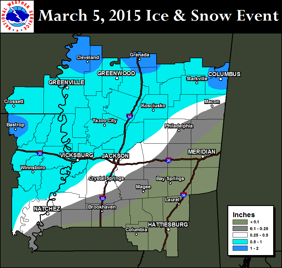
Those who received a good amount of sleet and some snow accumulation (mainly along and northwest of the Natchez Trace corridor) saw anywhere between 1/2 inch to 1-2 inches in the far northern parts of the Delta and northern Mississippi. Due to being warm the two previous days, road issues were mainly limited to areas that received significant heavy sleet accumulation, mainly in the Delta and northern Mississippi. These areas saw numerous roads that were ice covered and very slick, making travel very hazardous. Areas in the Jackson Metro saw some slick roads but warm ground and road temperature from the previous few days alleviated some of the issues.
Highest reported sleet and snow accumulation totals from March 5, 2015. Click to enlarge.
| Arkansas | ||
|---|---|---|
| Station | County | Snow Amount (inches) |
| Eudora | Chicot | 4.5 |
| Dermott | Chicot | 3 |
| Portland | Ashley | 3 |
| Crossett | Ashley | 3 |
| Louisiana | ||
|---|---|---|
| Station | Parish | Snow Amount (inches) |
| Bastrop | Morehouse | 3.5 |
| Oak Ridge | West Carroll | 3.5 |
| Delhi | Richland | 3 |
| Lake Providence | East Carroll | 2.3 |
| Tallulah | Madison | T |
| Mississippi | ||
|---|---|---|
| Station | County | Snow Amount (inches) |
| Bellefontaine | Webster | 8 |
| Mantee | Webster | 8 |
| Caledonia | Lowndes | 8 |
| Duck Hill | Montgomery | 8 |
| Gore Springs | Grenada | 8 |
| Elliot | Grenada | 8 |
| Montpelier | Clay | 7 |
| Grenada | Grenada | 7 |
| Holcomb | Grenada | 7 |
| Carrollton | Carroll | 7 |
| Cedar Bluff | Clay | 7 |
| Eupora | Webster | 7 |
| Grenada 8 NNW | Grenada | 6 |
| West Point | Clay | 6 |
| Shaw | Bolivar | 6 |
| Columbus Air Force Base | Lowndes | 6 |
| Cleveland | Bolivar | 6 |
| Reform | Choctaw | 5.5 |
| Cruger | Holmes | 5 |
| Mathison | Webster | 5 |
| Minter City | Leflore | 5 |
| Maben | Webster | 5 |
| Steens | Lowndes | 4.8 |
| 1N Indianola | Sunflower | 4.5 |
| 1N Starkville | Oktibbeha | 4.3 |
| Vaiden | Carroll | 4 |
| Belzoni | Humphrey | 4 |
| Columbus | Lowndes | 4 |
| Glen Allan | Washington | 4 |
| Fitler | Issaquena | 3.7 |
| Greenville | Washington | 3.5 |
| 4 W Ackerman | Choctaw | 3.5 |
| Duncan | Bolivar | 3.4 |
| Moorhead | Sunflower | 3 |
| Rolling Fork | Sharkey | 3 |
| Tchula | Holmes | 3 |
| Durant | Holmes | 2 |
| Holly Bluff | Yazoo | 2 |
| Louisville | Winston | 2 |
| Lexington | Winston | 2 |
| French Camp | Choctaw | 2 |
| Possumneck | Attala | 2 |
| Crawford | Lowndes | 1.5 |
| Mccool | Attala | 1.5 |
| Way | Madison | 1.5 |
| Kosciusko | Attala | 1.5 |
| Yazoo City | Yazoo | 1 |
| Carthage | Leake | 0.5 |
| Pearl River | Neshoba | 0.5 |
| Jackson Intl. Airport | Rankin | T |


 Follow us on YouTube