Event Summary
A strong upper disturbance propagated through the southern Great Plains into the lower Mississippi Valley by mid to late Friday afternoon. Strong upper level winds were supportive of damaging winds but winds in the lower levels were light, which decreased tornado potential Friday for the ArkLaMiss. Cold temperatures aloft and steep lapse rates (temperatures decreasing quicker than normal with height) increased instability across the region Friday. The higher instability brought the risk of large hail in the region. A low pressure system began to move into the area Friday afternoon and dewpoints climbed into the mid to upper 60s along and west of the I-55 corridor.
Storms began to rapidly developing in eastern Texas and central Arkansas late Friday afternoon. A few supercells developed in the far northwest Delta around 6-9pm Friday, which produced golf ball size hail in Ashley County in Arkansas and Washington County in Mississippi. Damaging straight line winds estimated near 85mph occurred near Portland, Arkansas in Chicot County with multiple power poles snapped along Highway 165 and an outbuilding was flipped over. An estimated 85mph straight line winds also caused damage near Eudora near Highway 65 where multiple power poles were snapped. A carport was thrown, few power poles were snapped and shingle damaged occurred on Grand Lake Loop.
To the west of the supercell storms that developed in southeast Arkansas, a squall line developed and rapidly propagated to the east. Damaging winds occurred along the squall line generally up to the Mississippi River and approached the I-55 corridor near midnight. However, lower instability existed along and east of I-55, which caused the squall line to weaken as it moved to the east. Showers and storms moved out of the region early Saturday morning.
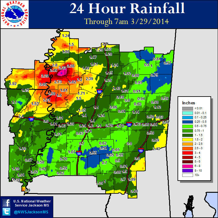
In addition to the strong storms, a combination of heavy rain was produced from the two disturbances that moved through Thursday and Friday nights. Widespread 3-5 inches of rain, with some locally higher amounts, fell across the region. Rivers rose quickly in response to the heavy rainfall, which caused minor to moderate flooding across the region.
Damage Survey Map
Click on map above to see entire event tracks and damage point notation. Additional information also available on individual severe thunderstorm pages.
Survey Information - Click on the location in the table for additional maps and details
| Location | Start/ End Time |
Event Type | Fatalities/ Injuries |
Path Length | Path Width |
| Ashley County 4 S Portland to 4 SE Portland |
8:50 pm - 8:59 pm |
Straight-line wind 85 mph |
none | 3.0 miles | 1.0 miles |
| Chicot County 1.5 SE Eudora to 2.5 ESE Eudora |
9:14 pm - 9:17 pm |
Straight-line wind 85 mph |
none | 1.5 miles | 500 yards |
Local Storm Reports
Click on the map below for additional details.
Rainfall Totals
Storm Total Rainfall
 |
 |
Mississippi Rainfall Totals
 |