
Event Summary
This outbreak broke a streak of 3 years when no tornadoes occurred during the month of November across Mississippi. Additionally, the last Fall outbreak of tornadoes occurred on November 24, 2004. Historically, November marks the peak of our 2nd severe weather season and ranks 3rd as the most active month for tornadoes in Mississippi, just a few behind March.
Tornado Track Map
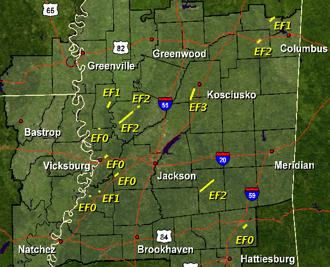
Tornado Information
Click on Each County Location for Additional Tornado Details
| Location | Start/ End Time |
EF Rating/ Max Wind Speed |
Fatalities/ Injuries |
Path Length | Path Width |
| Sharkey County 4 NNW Holly Bluff to 9 ESE Anguilla |
Mon 11/29 7:19 pm - 7:23 pm |
EF-1 95 mph |
0 | 3.5 mi | 100 yds |
| Issaquena/Sharkey Counties 1.5 NNE Valley Park to 2.5 NNE Valley Park |
Mon 11/29 7:25 pm - 7:27 pm |
EF-0 80 mph |
0 | 1 mi | 50 yds |
| Yazoo County 15.5 SW Yazoo City to 4 SW Yazoo City |
Mon 11/29 7:46 pm - 8:00 pm |
EF-2 125 mph |
0 | 11.5 mi | 200 yds |
| Warren County 3 NE Vicksburg to 4.5 NE Vicksburg |
Mon 11/29 8:04 pm - 8:06 pm |
EF-0 70 mph |
0 | 1.5 mi | 25 yds |
| Yazoo County Yazoo City to 7 NE Yazoo City |
Mon 11/29 8:07 pm - 8:19 pm |
EF-2 115 mph |
0 | 7 mi | 150 yds |
| Claiborne County 4.3 WNW Port Gibson |
Mon 11/29 8:30 pm - 8:30 pm |
EF-0 65 mph |
0 | 100 yds | 10 yds |
| Hinds County 7.6 NNW Utica to 4 S Edwards |
Mon 11/29 9:09 pm - 9:18 pm |
EF-0 70 mph |
0 | 7 mi | 50 yds |
| Claiborne County 6.2 NNE Port Gibson to 6.3 NNE Port Gibson |
Mon 11/29 9:25 pm - 9:26 pm |
EF-1 90 mph |
0 | 0.25 mi | 20 yds |
| Leake/Attala Counties 3.5 NW Thomastown to 3 E McAdams |
Mon 11/29 9:38 pm - 9:50 pm |
EF-3 140 mph |
Injured: 6 | 10 mi | 400 yds |
| Oktibbeha County 1.5 SW Starkville to Starkville |
Mon 11/29 11:08 pm - 11:09 pm |
EF-2 115 mph |
Injured: 15 | 1.5 mi | 200 yds |
| Clay County 3 NNW West Point to 4 N West Point |
Mon 11/29 11:26 pm - 11:29 pm |
EF-1 90 mph |
0 | 2 mi | 150 yds |
| Smith County 2.5 E Traxler to 6 NE Raleigh |
Tue 11/30 2:43 am - 2:58 am |
EF-2 125 mph |
0 | 11 mi | 0.3 mi |
| Jones County Tuckers Crossing to 7 NE Tuckers Crossing |
Tue 11/30 5:50 am - 5:58 am |
EF-0 80 mph |
0 | 7 mi | 30 yds |


 Follow us on YouTube