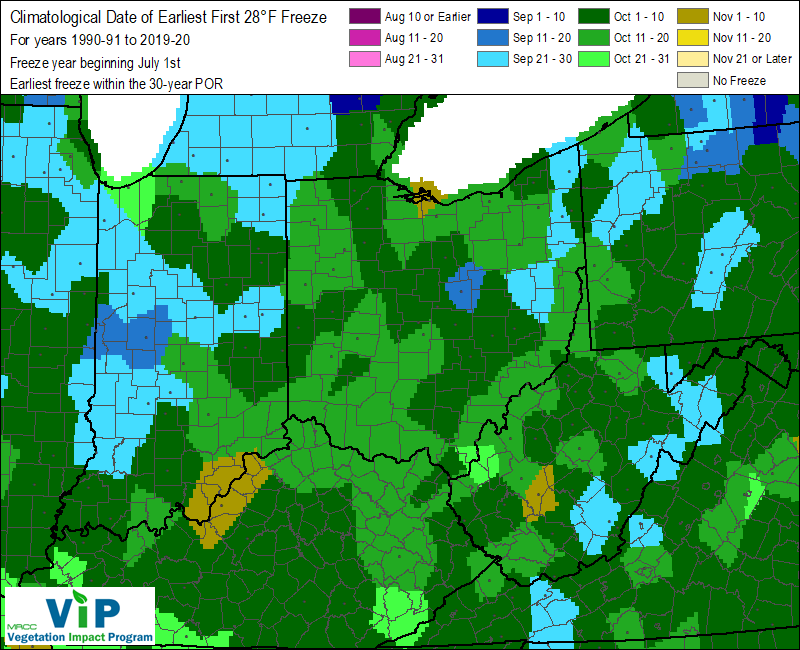
The fall season is underway across the area and it's the time of year when the possibility for frost and freezing temperatures at night return. Typically, frost can occur when the temperature falls below 36°F, especially in rural areas. It is a localized phenomena and can be quite variable across a small area. While the National Weather Service does not keep track of "frost" in observations per se, we do keep track of when temperatures hit the freezing mark or fall below. Frost becomes more widespread when the temperature falls below 32°F with some freeze possible. A hard freeze is possible when temperatures fall below 28°F. The maps below, courtesy of the Midwestern Regional Climate Center, show the average dates for the first freeze and hard freeze of the fall. Click on the images for a larger resolution.
 |
 |
 |
 |
The table below shows the normal first, earliest first, and latest first date of temperatures at or below 32°F for the fall season at locations across the area.
| Location | Average First Date* | Earliest Date | Latest Date | Record Period |
| Benton Harbor | October 13 | September 13, 2017 (1985) | November 26. 1890 | 1890-present |
| Defiance, OH | October 19 | October 1, 2009 | November 11, 2016 | 1998-present |
| Fort Wayne | October 15 | September 23, 1995 (1974, 1967) | November 24, 1931 | 1912-present |
| Goshen, IN | October 13 | October 1, 2009 | October 28, 2007 | 1997-present |
| Lima, OH | October 18 | October 1, 2009 | November 12, 2016 | 1998-present |
| South Bend | October 17 | September 21, 1897 | November 11, 1985 | 1893-present |
*Averages are computed as a simple mean for the 30 year period of 1991 to 2020 and should not be considered a "climatological normal"
(i.e., not an official climate normal calculated by NCEI)
The table below shows the normal first, earliest first, and latest first date of temperatures at or below 28°F for the fall season at locations across the area.
| Location | Normal First Date* | Earliest Date | Latest Date | Record Period |
| Benton Harbor | October 26 | September 24, 1989 | December 4, 1899 | 1890-present |
| Defiance, OH | October 28 | October 14, 2002 | November 14, 2022 | 1998-present |
| Fort Wayne | October 29 | October 3, 1974 | November 25, 1931 | 1912-present |
| Goshen, IN | October 24 | October 2, 2003 | November 14, 2022 | 1997-present |
| Lima, OH | October 30 | October 14, 2002 | November 14,2022 | 1998-present |
| South Bend | November 3 | October 2, 1908 | November 26, 1902 | 1893-present |
*Averages are computed as a simple mean for the 30 year period of 1991 to 2020 and should not be considered a "climatological normal"
(i.e., not an official climate normal calculated by NCEI)
Click on the maps below to go to the most recent versions of the data from Midwestern Regional Climate Center.
 |
 |
Page updated, all data tables 10/13/2024 -KB

